INTERNATIONAL COURT OF JUSTICE
CASE CONCERNING
MARITIME DELIMITATION IN THE INDIAN OCEAN
SOMALIA
v.
KENYA
MEMORIAL OF SOMALIA
VOLUME I
13 JULY 2015 TABLE OF CONTENTS
Chapter 1. Introduction............................................................................................1
Section I. Reasons for the Institution of Proceedings against
Kenya......................................................................................2
Section II. Structure of the Memorial.......................................................9
Chapter 2. The Geography, Geology and Geomorphology of Somalia and
Kenya...................................................................................................15
Section I. The Geographical Circumstances.........................................15
A. The Geography of Somalia................................................15
B. The Geography of Kenya...................................................20
Section II. The Geological and Geomorphological Circumstances.......23
Chapter 3. History of the Dispute..........................................................................27
Section I. Maritime Zones of the Parties...............................................27
A. Somalia ..............................................................................27
B. Kenya.................................................................................30
Section II. The Parties’ Claims in the Outer Continental Shelf..............37
A. Somalia ..............................................................................37
B. Kenya.................................................................................39
Section III. The Parties’ Efforts to Negotiate a Maritime Boundary
Agreement.............................................................................41
Chapter 4. Location of the Land Boundary Terminus and the Starting Point
of the Maritime Boundary....................................................................51
Chapter 5. Delimitation of the Territorial Sea .......................................................61
Section II. The Law Governing the Delimitation of the Territorial
Sea.........................................................................................62
ii A. The United Nations Convention on the Law of the
Sea......................................................................................62
B. Baselines............................................................................65
C. Base Points and the Construction of the Equidistance
Line....................................................................................67
D. Absence of Special Circumstances....................................68
Section III. Kenya’s Claim to a Parallel of Latitude Boundary...............71
Chapter 6. Delimitation of the EEZ and ContinentAL Shelf within 200 M..........75
Section I. The Applicable Law..............................................................76
A. The Regimes of the EEZ and Continental Shelf................76
B. International Judicial and Arbitral Practice .......................78
Section II. The Identification of the Relevant Coasts and Relevant
Area.......................................................................................81
B. The Relevant Coasts..........................................................81
C. The Relevant Area.............................................................86
Section III. The Delimitation of the Maritime Boundary between
Somalia and Kenya...............................................................89
A. The Application of the Three-Step Method.......................89
Chapter 7. Delimitation of the Continental Shelf Beyond 200 M .........................97
Section I. The Jurisdiction of the Court to Delimit the Continental
Shelf Beyond 200 M.............................................................98
A. The Respective Roles of the Court and the CLCS with
Regard to the Continental Shelf beyond 200 M.................98
B. The Court’s Exercise of Jurisdiction in this Case Does
Not Prevent the CLCS from Examining the Two
Parties’ Submissions........................................................106
iii Section II. The Respective Claims of Somalia and Kenya Beyond
200 M..................................................................................111
Section III. Delimitation of the Continental Shelf Beyond 200 M........114
A. Applicable Law................................................................114
B. Application of the Legal Principles to the Present
Case..................................................................................117
Section IV. No Encroachment on Tanzania’s Entitlements Beyond
200 M..................................................................................124
Chapter 8. Kenya’s Responsibility for Illegal Activities in the Disputed
Area....................................................................................................127
Section I. The Admissibility of Somalia’s Claim Concerning
Kenya’s Responsibility for Unlawful Conduct..................127
Section II. Kenya’s Violation of Somalia’s Sovereignty and
Sovereign Rights Triggers Its International
Responsibility.....................................................................130
A. The Principle of Exclusivity of Rights in Maritime
Zones................................................................................130
B. Kenya’s Unilateral Activities in the Disputed Area are
Unlawful ..........................................................................135
Section III. Consequences of Kenya’s Responsibility...........................141
Submissions.........................................................................................................147
ivv CHAPTER 1. INTRODUCTION
1.1. The Federal Republic of Somalia instituted these proceedings against the
Republic of Kenya on 28 August 2014 when it filed an Application to the Court
in accordance with Article 36, paragraphs 1 and 2, and Article 40 of the Statute of
the Court. As set out in the Application, this case concerns the interpretation and
application of the 1982 United Nations Convention on the Law of the Sea
(“UNCLOS” or the “Convention”) and customary international law with respect
to the establishment of
“the single maritime boundary between Somalia
and Kenya in the Indian Ocean delimiting the
territorial sea, exclusive economic zone … and
continental shelf, including the continental shelf
beyond 200 nautical miles …”. 1
1.2. By an Order dated 16 October 2014, the Court fixed the time limit for the
filing of the Memorial by Somalia as 13 July 2015 and the time limit for the filing
of the Counter-Memorial by Kenya as 17 May 2016. This Memorial is submitted
pursuant to that Order.
1.3. Somalia has brought these proceedings in accordance with its firm
commitment to the rule of international law, in order to determine its disputed
maritime boundary with Kenya in a manner that is peaceful, equitable and legally
conclusive.
1.4. Prior to the institution of these proceedings, Somalia sought to resolve the
dispute with Kenya through good faith negotiations. Somalia entered that
dialogue in a spirit of respect and with a desire to promote friendly relations with
1 Maritime Delimitation in the Indian Ocean (Somalia v. Kenya), Application Instituting
Proceedings (28 Aug. 2014), para. 2.
1its valued neighbour, with whom it shares many historical and cultural ties and
common interests. Somalia regrets that these negotiations did not lead to a
mutually acceptable solution.
1.5. Somalia’s Application to the Court is made in the same spirit of respect
and friendly cooperation, consistent with the Convention’s aim to “promote the
peaceful uses of the seas and oceans”. 2 The Application has been brought with
the aim of having the Court delimit the boundary that will divide the maritime
areas of the two States in accordance with the requirements of international law,
and to do so from the land boundary terminus, through the territorial sea, into the
exclusive economic zone (“EEZ”) and continental shelf up to 200 nautical miles
(“M”), and into the continental shelf beyond 200 M.
Section I. Reasons for the Institution of Proceedings against Kenya
1.6. Somalia was compelled to bring these proceedings as a result of Kenya’s
unilateral claim to a maritime boundary extending due east into the Indian Ocean
along a parallel of latitude from the terminal point of the Parties’ land boundary.
The boundary claimed by Kenya represents an attempt a significant effort to
expand Kenya’s maritime jurisdiction, as well as a serious encroachment into
Somalia’s maritime spaces.
1.7. Somalia considers Kenya’s claim to be inconsistent with international law
for the reasons set out in the chapters that follow. A boundary along a line of
parallel has no basis the Convention and cannot be justified by reference to any
aspect of the history, geography or relevant practice of either Party, all of which
2United Nations Convention on the Law of the Sea (hereinafter “UNCLOS”), Preamble.
2instead support a boundary based on equidistance. Kenya’s claim notably appears
to be contrary to the position enshrined in its own domestic legislation.
1.8. Kenya’s unprecedented and unjustifiable claim violates Somalia’s
territorial integrity, and its sovereign rights and jurisdiction. Kenya has,
moreover, purported to grant commercial oil concessions in the areas located
between its parallel boundary claim and the equidistance line claimed by Somalia.
In so doing, Kenya has sought to dispossess Somalia not only of significant areas
of maritime space, but also of substantial living and non-living resources.
1.9. As adjacent States on the coast of East Africa, Somalia and Kenya share a
common history of imperial conquest and decades of colonial rule by Italy and
the United Kingdom (Somalia) and the United Kingdom alone (Kenya). The two
States attained independence just a few years apart: Somalia in 1960, Kenya in
1963. In the half -century after the end of colonial rule, however, the fortunes of
the two Parties diverged.
1.10. Since independence Kenya has enjoyed relatively stable democratic
government and steady economic development. Today it is the largest economy
in East Africa, with substantial natural resources and GDP per capita almost ten
times that of Somalia. 3
1.11. In contrast, Somalia has endured decades of civil conflict, humanitarian
disasters and terrorism that have depleted its limited natural resources and, at
3 According to the United Nations National Accounts Main Aggregates Database, in 2013 (the
most recent year for which statistics are available) Kenya’s GDP per capita was US$ 1,227.
Somalia’s GDP per capita was US$ 133. See United Nations, Statistics Division, National
Accounts Main Aggregates Database, “Per Capita GDP in US Dollars” (Dec. 2014), available
athttp://unstats.un.org/unsd/snaama/dnllist.asp (last accessed 26 2015). Memorial of the
Federal Republic of Somalia (“MS”), Vol. IV, Annex 73.
3times, threatened its functioning as a stable State. Its post- independence history
has been dominated by instability, poverty and a civil war that led to the collapse
of effective central government for two decades. Since 1991, a number of
external actors seized upon the absence of effective government to exploit
Somalia’s terr itory and resources for their own ends. Terrorism thrived and
economic stagnation inflicted a terrible humanitarian toll.
1.12. Since 2012, the Federal Government of Somalia has, with the support of
international partners, governed the country under a new national constitution.
This places the rule of law, parliamentary democracy and human rights at the
heart of the constitutional order. It has a functioning federal government under
the leadership of H.E. Hassan Sheikh Mohamud. Governmental and regional
institutions that can deliver adequate services to the people are being rebuilt, and
life has sprung back in major cities in Somalia including Mogadishu, Hargeissa,
Bossaso, Kismayo, Baldwayne, Baidoa and many other places throughout the
country. Local businesses a re thriving; a new generation of educated Somalis is
graduating from various educational institutions, and a significant number of the
Somali diaspora are returning to their homeland.
1.13. For the first time in its history as an independent country, Somalia is able
to make effective use of international dispute mechanisms to protect its rights
under international law —including its rights over its territorial and maritime
resources—for the benefit of all of its citizens. The present case marks an
important moment in Somalia’s progress in this respect.
1.14. As one of the world’s poorest countries, Somalia’s maritime resources are
particularly valuable natural assets. As these resources assume increasing
importance for Somalia’s future development, Kenya’s unilateral cla im to a
maritime boundary that follows a parallel of latitude would deprive Somalia of
4some of its most important marine and mineral resources, which Somalia views
as keys to its economic development, stability and security.
1.15. Against this background, Somalia has two principal objectives in bringing
these proceedings. First , it seeks to obtain the definitive delimitation of its
maritime boundary in the territorial sea, the EEZ and the continental shelf,
including the continental shelf beyond 200 M. Second, it asks for a judgment
recognizing that Kenya has violated Somalia’s territorial integrity and sovereign
rights and jurisdiction by awarding commercial oil concessions in Somalia’s
territorial sea, EEZ and continental shelf.
1.16. The jurisdiction of the Court, i n regard to these matters, is plainly
established on the basis of Declarations made by the Parties under the optional
clause contained in Article 36, paragraph 2, of the Statute of the Court. Somalia’s
Declaration, made on 11 April 1963, contains nothing t hat might give rise to any
limitation on the jurisdiction of the Court in relation to the matter submitted in the
Application. 4 Kenya’s Declaration, made on 19 April 1965, contains four
4Somalia’s Declaration provides:
“I have the honour to declare on behalf of the Government of the Somali
Republic that the Somali Republic accepts as compulsory ipso facto , and
without special agreement, on condition of reciprocity, the jurisdiction of the
International Court of Justice, in conformity with paragraph 2 of Article 36 of
the Statute of the Court, until such time as notice may be given to terminate the
acceptance, over all legal disputes arising other than disputes in respect of
which any other party to the dispute has accepted the compulsory jurisdiction of
the International Court of Justice only in relation to or for the purposes of the
dispute; or where the acceptance of the Court’s compulsory jurisdiction on
behalf of any other Party to the dispute was deposited or ratified less than
twelve months prior to the filing of the application bringing the dispute before
the Court. The Somali Republic also reserves t he right at any time by means of
a notification addressed to the Secretar-General of the United Nations, and
with effect as from the moment of such notification, either, to add to, amend or
withdraw any of the foregoing reservations, or any that may herea fter be
added”.
5 5
exceptions, none of which operate to exclude jurisdiction in the prese nt case.
The consensual basis for the Court’s jurisdiction is plainly established by the
existence of convergent Article 36(2) declarations, which “afford a basis for the
jurisdiction of the Court”. 6 Accordingly, the Court has full jurisdiction to settle
the dispute submitted to it by Somalia. There are no grounds for the Court to
decline to exercise that jurisdiction.
(Declarations recognizing the jurisdiction of the Court as compulsory are available at
http://www.icj-cij.org/jurisdiction/?p1=5&p2=1&p3=3&code=SO.)
5
Kenya’s Declaration provides that:
“it accepts, in conformity with paragraph 2 of Articl e 36 of the Statute of the
International Court of Justice until such time as notice may be given to
terminate such acceptance, as compulsory ipso facto and without special
Agreement, and on the basis and condition of reciprocity, the jurisdiction over
all disputes arising after 12th December, 1963, with regard to situations or facts
subsequent to that date, other than:
1. Disputes in regard to which the parties to the dispute have agreed or
shall agree to have recourse to some other method or methods of
settlement;
2. Dispute with the government of any State which, on the date of this
Declaration is a Member of the Commonwealth of Nations or may so
become subsequently;
3. Disputes with regard to questions which by general rules of
International Law fall exclusively within the jurisdiction of Kenya;
4. Disputes concerning any question relating to or arising out of
belligerent or military occupation or the discharge of any functions
pursuant to any recommendation or decision of an organ of the United
Nations, in accordance with which the Government of the Republic of
Kenya have accepted obligations.
The Government of the Republic of Kenya reserves the right at any time by
means of a notification addressed to the Secretary -General of the United
Nations to add to , amend, or withdraw any of the foregoing reservations. Such
notifications shall be effective on the date of their receipt by the Secretary -
General of the United Nations”.
6
Military and Paramilitary Activities in and against Nicaragua (Nicaragua v. Unite d States of
America), Jurisdiction and Admissibility, Judgment, I.C.J. Reports 1984, para. 110. See also , e.g.,
ibid., paras. 59 -60; Anglo-Iranian Oil Co. (United Kingdom v. Iran) , Preliminary Objection,
Judgment, I.C.J. Reports 1952, p. 103; Certain Norwe gian Loans (France v. Norway), Judgment,
I.C.J. Reports 1957, p. 19; Fisheries Jurisdiction (Spain v. Canada), Jurisdiction of the Court,
Judgment, I.C.J. Reports 1998, para. 44.
61.17. As regards the merits, a number of fundamental points are in order. First ,
the geography of the Somali and Kenyan coastlines are unremarkable, having a
straightforward and stable configuration. As can be seen in Figure 1.1 (following
page 8), the Parties’ coasts abutting the area to be delimited are straight and
smooth. There are no significant recesses, protuberances or other formations that
might affect the delimitation process. Unlike many other disputed maritime
boundaries, the Court is not called upon here to consider the effects of any
complex or anomalous coastal features , or to modify established principles of
maritime delimitation to take account of unstable land formations. The
delimitation exercise is straightforward.
1.18. Second, the Parties have never concluded any agreement, written or
otherwise, concerning the delimita tion of their maritime boundary. Both are
bound by the Convention and have emphasised their commitment to honouring its
provisions, including in relation to the delimitation of their maritime boundaries.
1.19. Third, the regularity of the geographic circumstances of the coastline, and
the absence of any bilateral agreement departing from the principles to be applied
under the Convention make this a case par excellence for the application of the
equidistance/special circumstances principle (in the territorial sea ) and the closely
related equidistance/relevant circumstances principle (in the EEZ and continental
shelf), in accordance with Articles 15, 74 and 83 of the Convention.
1.20. Equidistance is “the general rule” 7 and “[t]he usual methodology”
applicable to maritime delimitation disputes. 8 Accordingly, the Court’s case law
establishes that the delimitation exercise must begin with the drawing of a
7 Territorial and Maritime Dispute between Nicaragua and Honduras in the Caribbean Sea
(Nicaragua v. Honduras), Judgment, I.C.J. Reports 2007, para. 281.
8
Maritime Dispute (Peru v. Chile), Judgment, I.C.J. Reports 2014, para. 184.
7provisional equidistance line unless there exist “compelling reasons” to make this
“unfeasible”. 9 In the present case t here are no reasons —compelling or
otherwise—that would make a provisional equidistance line difficult to draw or
otherwise unfeasible. To the contrary, the configuration of the relevant coastlines
makes the identification of appropriate base points and the construction of an
equidistance line quite simple.
1.21. Nor, importantly, are there any special or relevant circumstances that
warrant an adjustment to the equidistance line in the interests of achieving an
“equitable” result. In the context of the straight and unexceptional Somalia-Kenya
coastline, equidistance is the only equitable result. Indeed, any departure from
equidistance would ignore the foundational principle of maritime delimitation
that “the land dominates the sea”, 10 since it would produce an arti ficial cut-off
resulting from an irregular maritime boundary at odds with the regular
configuration of the land from which the maritime entitlements derive.
1.22. In contrast to the equidistance line, the parallel boundary Kenya claims
lacks any coherent legal basis. Kenya has previously sought to justify the parallel
line by reference to a vague appeal to “equitable principles”, claiming that an
equidistant boundary would be inequitable in light of the maritime boundary that
Kenya negotiated with its southern neighbour, Tanzania, in 1976 and 2009. That
argument is entirely without merit.
1.23. Kenya freely negotiated a parallel boundary with Tanzania and voluntarily
undertook to be bound by that maritime border. It cannot now invoke what it
9 Maritime Delimitation in the Black Sea (Romania v. Ukraine) , Judgment, I.C.J. Reports 2009,
para. 116.
10
North Sea Continental Shelf (Federal Republic of Germany/Netherlands) , Judgment, I.C.J.
Reports 1969, para. 96.
8 44°E 46°E
THE PARTIES’ COASTS ABUTTING THE AREA
TO BE DELIMITED
Mercator Projection
WGS-84 Datum
(Scale accurate at 2°S) ETHIOPIA
0 50 100 150 200 300
Nautical Miles
0 100 200 300 400 500 6°N
Kilometers
High tide coastlines are based on the NGA Prototype Global Shoreline Dat
a Base.
Supplemental shoreline information was digitized from NGA charts 61210,
61220, 61230,
61240, 61250, 61260,61270, 61280, 62050, 62070, 62080 and 62090.
Prepared by: International Mapping
4°N 4°N
SOMALIA
Cadale
MOGADISHU
2°N 2°N
0° 0°
Kismaayo
KENYA
Buur Gaabo
2°S 2°S
200 M limit
4°S 4°S
Mombasa
INDIAN
TANZANIA
Pemba I. OCEAN
40°E 42°E 44°E 46°E
38°E
Figure 1.1perceives as the negative consequences of that agreement in order to seek to
diminish Somalia’s sovereign rights and jurisdiction. Kenya alone bears
responsibility for the consequences of the agreement it entered into with
Tanzania. In regards to Somalia, the Kenya -Tanzania agreements are res inter
alios acta and they cannot be invoked against Somalia to “compensate” Kenya
for the consequences of the bargain in made hundreds of miles to the south.
1.24. In any event, it is clear that an unadjusted equidistance line between
Somalia and Kenya does not produce an outcome that is disproportionate to the
Parties’ relevant coasts. In contrast to Kenya’s unjustifiable claim, there is
nothing inequitable in applying the standard method of delimitation to the wholly
unremarkable coastlines of Somalia and Kenya.
Section II. Structure of the Memorial
1.25. Somalia’s Memorial consists of four volumes. Volume I contains the main
text of the Memorial, along with selected maps and diagrams. Volume II contains
a full set of figures and maps. Volumes III and IV contain addi tional supporting
materials.
1.26. The main text of the Memorial, Volume I, consists of eight chapters
followed by Somalia’s Submissions. After this Introduction, Chapter 2 describes
the geographical, geologic and geomorphological context of this dispute.
1.27. Chapter 3 addresses the history of the dispute, beginning with the
relevant provisions of the Parties’ maritime laws, which disclose the
contradictory and unpredictable approach taken by Kenya in relation to its
maritime boundary with Somalia. As will be seen, both Parties have enacted
legislation that is intended to bring their domestic law in line with the Convention
9and is consistent with an equidistant maritime boundary. In particular, Kenya’s
1972 Territorial Waters Act and 1989 Maritime Zones Act expressl y provides for
an equidistant delimitation of the territorial sea, while also providing that the EEZ
boundary “shall be delimited … pursuant to an agreement between Kenya and
Somalia on the basis of international law”. 11
1.28. Despite these provisions, in 1979 a nd then again in 2005 the President of
Kenya made unilateral proclamations laying claim to a parallel boundary in both
the territorial sea and the EEZ. Consistent with these Presidential Proclamations,
Kenya has offered a number of petroleum blocks for deep- water exploration and
drilling in areas across the equidistance line that extend up to the claimed parallel
boundary.
1.29. The chapter then addresses the Parties’ respective submissions to the
Commission on the Limits of the Continental Shelf (“CLCS”) in regard to the
extent—but not the delimitation —of the continental shelf beyond 200 M. It
concludes by summarising the Parties ’ unsuccessful efforts to negotiate a
maritime boundary agreement, and the sequence of events that ultimately led
Somalia to initiate these proceedings.
1.30. Chapter 4 describes the location of the Parties’ land boundary terminus,
the starting point of the mar itime boundary. The terminal point of the Parties’
land boundary was defined with a high degree of precision in a treaty and
subsequent agreement between the two colonial powers in 1924 and 1927,
respectively. The recognised starting point of the maritime boundary is situated
on the low-water line approximately 41 metres southeast of the final permanent
11Republic of Kenya, Chapter 371, Maritime Zones Act(25 Aug. 1989), § 4(4). MS, Vol. III,
Annex 20.
10boundary beacon (Primary Beacon No. 29) at the location known as “Dar Es
Salam”.
1.31. Chapter 5 concerns the delimitation of the territorial sea. It shows that
since at least 1972, Kenya’s domestic legislation has expressly recognised that
the maritime boundary with Somalia in the territorial sea should follow an
equidistance line. The parallel boundary Kenya now claims directly contradicts
its own legislation. In these circumstances, there is nothing to displace the
presumption under Article 15 of the Convention in favour of an equidistance line
within the territorial sea.
1.32. Chapter 6 concerns the delimitation of the EEZ and the continental shelf
within 200 M. It explains the legal and factual basis for Somalia’s claim that the
boundary continues along a strict equidistance line with a general bearing of
approximately N124.5°E from the outer limit of the territorial sea to the outer
edge of the EEZ.
1.33. The chapter be gins with a brief review of the applicable law, and then
explains why the standard three -step analytical framework known as the
“equidistance/relevant circumstances” method is the appropriate approach in this
case. It shows how the application of this method compels the conclusion that the
equidistance line constitutes an equitable solution that is fully justified in light of
the Parties’ conspicuously smooth and unexceptional coasts. Indeed, if
equidistance is not appropriate in the circumstances of this c ase, it is hard to
imagine a case in which it would be. In this connection, the chapter also identifies
the relevant coasts of the Parties and the relevant area, and explains how
appropriate base points have been selected in accordance with established
principles for the purpose of constructing the equidistance line.
111.34. Chapter 7 addresses the delimitation of the continental shelf beyond 200
M. It begins by demonstrating the Court’s jurisdiction to delimit the “outer”
continental shelf. In this respect, it distinguishes the Court’s task in delimiting the
maritime boundary between Somalia and Kenya from the entirely separate role of
the CLCS, which is responsible for delineating the precise outer limits of the
continental margin. Moreover, both Kenya and Somali a have made full
submissions to the CLCS concerning the extent of their respective continental
shelves beyond 200 M. There is therefore no legal or practical impediment to the
Court’s determination of the path of the Parties’ maritime boundary while the
CLCS is engaged in the task of delineating the full extent of their continental
shelves beyond 200 M.
1.35. The legal principles applicable to delimitation of the continental shelf
beyond 200 M are the same as those applicable to delimitation within 200 M.
Accordingly, the chapter proceeds to explain why, as in the case of the
delimitation of the EEZ and the continental shelf within 200 M, there are no
relevant circumstances that require a modification of the provisional equidistance
line beyond 200 M. Any reduction in Kenya’s overall maritime entitlement
beyond 200 M could only arise as a result of Kenya’s bilateral agreement with
Tanzania, by which Kenya voluntarily divested itself of a very large maritime
area south of the negotiated parallel boundary. As a matte r of law, Somalia
cannot be required to compensate Kenya for the consequences of its own past
actions.
1.36. Finally, Chapter 8 concerns Kenya’s international responsibility for
illegal activities in the disputed maritime area. The chapter begins by explaining
how Kenya’s unilateral economic exploitation of the disputed maritime area
constitutes an unlawful infringement of Somalia’s sovereign rights and
jurisdiction. It then addresses the remedies to which Somalia is entitled in respect
12of these on-going violations. Kenya is obliged to cease all wrongful acts and must
deliver to Somalia all the data it has acquired through exploration of areas that
pertain to Somalia. Further, to the extent that Kenya is unable to make good the
wrongs done to Somalia by restitutio n, it is under a duty to compensate Somalia
for the damage caused by the appropriation of, and interference with, its
sovereignty and sovereign rights and jurisdiction over the territorial sea, EEZ and
continental shelf.
1.37. The Memorial concludes with Somalia’s Submissions.
1314CHAPTER 2. THE GEOGRAPHY, GEOLOGY AND
GEOMORPHOLOGY OF SOMALIA AND KENYA
2.1. This chapter describes the geographical, geological and geomorphological
circumstances relevant to the delimitation of the maritime boundary between
Somalia and Kenya. Section I describes the geographical circumstances that are
most pertinent to the delimitation of the maritime boundary within 200 M.
Section II addresses the geological and geomorphological circumstances that are
most pertinent to the delimitation of the maritime boundary in the continental
shelf beyond 200 M.
Section I. The Geographical Circumstances
A. THE G EOGRAPHY OF SOMALIA
2.2. Somalia is located on the East Coast of Africa between latitudes 12°00’ N
and 1°40’ S, and between longitudes 41°00’ and 51°25’ E. It is the easternmost
country on mainland Africa, and the most prominent on the Horn of Africa.
Indeed, the country’s pointed shape gives the Horn its name. Somalia’s location
is shown in Figure2.1 (following page 16).
2
2.3. Somalia has a land area of approximately 640,000 km and a population
estimated at 10.4 million. It shares land boundaries with Djibouti in the far
northwest, Ethiopia in the west and Kenya in the southwest. The only portion of
these boundaries that is relevant to these proceedings is the final segment of the
land border with Kenya running southeast from approximately the 41°33’ E
meridian to the land boundary terminus (“LBT”) on the Indian Ocean. This
15portion of the boundary is described in detail in Chapter 4 concerning the precise
12
location of the LBT.
2.4. Somalia’s largest city is its capital, Mogadishu, which has a population of
approximately 1.35 million. It is located some 641 km northeast of the LBT with
Kenya on th e Indian Ocean coast. This location has made it a strategic trade
13
center since the 12th century. While the Mogadishu port has not been as active
in recent years, it remains key to Somalia’s international trade.
2.5. The other large city on Somalia’s southeastern coast is Kismaayo, located
approximately 437 km southwest of Mogadishu and 204 km northeast of the
LBT. Like Mogadishu, it is the site of an important deep- water port. Today, it is
the main point of shipment for Somalia’s exports.
2.6. Somalia straddles th e Equator near its southern tip. Its climate is mostly
arid to semi- arid and, in the north and coastal areas, semi -desert.14 Most of
Somalia receives less than 500 mm of rain a year, 15 with a country annual
12See, infra, paras. 4.15-4.24.
13
U.N. Environment Programme, The State of the Environment in Somalia: A Desk Study (Dec.
2005), p. 24. MS, Vol. IV, Annex 88.
14Ibid., pp. 38, 40.
15A. C. Beier and E. Stephansson, Environmental and Climate Change Policy Brief: Somalia (28
Oct. 2012), p. 4. MS, Vol. IV, Annex 92.
16 40°E 45°E 50°E
YEMEN
ERITREA
Socotra I.
Gulf of Aden
DJIBOUTI
10°N 10°N
ETHIOPIA
5°N 5°N
200 M limit
SOMALIA
KENYA
0° 0°
INDIAN
OCEAN
SEYCHELLES
5°S 5°S
Pemba I.
Zanzibar I.
TANZANIA
Mafia I.
8°S
THE GENERAL GEOGRAPHICAL
SEYCHELLES
SETTING
Mercator Projection
10°S WGS-84 Datum 10°S
(Scale accurate at 2°S)
COMOROS 0 100 200 300 400
Nautical Miles
0 200 400 600 80012°S
MOZAMBIQUE MADKilometers
High tide coastlines are based on the NGA Prototype Global Shoreline Dat
a Base.
40°E 45°E 50°E
Prepared by: International Mapping
Figure 2.1 16 17
average of 250 mm. Its vegetation is mostly dry, deciduous bush and thicket.
18
Only about 1.73% of its land is arable.
2.7. Somalia has a longer coastline than any other country in mainland East
Africa. From the boundary with Djibouti in the northwest, Somalia’s coast runs
generally from west to east along the Gulf of Aden for approximately 1000 km to
the Horn of Africa, where it makes an abrupt turn to the southwest and follows
the Indian Ocean for another 2000 km to the LBT with Kenya.
2.8. Somalia’s Indian Ocean coast can be divided into two parts. The first part
of the coast, from the tip of the Horn to the point approximately 92 km northeast
of Mogadishu (just south of Cadale), 19faces generally east-southeast. The second
part of the coast runs from the point just described to the LBT with Kenya. This
portion of the Somali coast is approximately 733 km in length and faces virtually
due southeast.
2.9. Somalia’s southeast -facing coast is generally smooth and regular,
including the portion running from Mogadishu to the LBT with Kenya. It has
sandy beaches punctuated with occasional rocky outcroppings and cliffs. These
16
F. Carbone et al., “The Modern Coral Colonization of the Bajuni Barrier Island (Southern
Somalia): A Facies Model for Carbonate -Quartzose Sedimentation”, Geologica Romana, Vol. 35
(1999), p. 114. MS, Vol. IV, Annex 86.
17
U.N. Environment Programme, The State of the Environment in Somalia: A Desk Study , p. 40.
MS, Vol. IV, Annex 88.
18 U.S. Central Intelligence Agency, The World Factbook: Somalia, available at
https://www.cia.gov/library/publications/the-world-factbook/geos/so.html (last visited 3 Apr.
2015), p. 2. MS, Vol. IV, Annex 96.
19This point is located at coordinates 2°26’28.9”N - 46°01’26.1”E.
17areas of the coast are known in Somali as Dhulka Deexda, or the land “without
20
high shrubs or trees”.
2.10. Near the LBT and just southwest of Ras Kaambooni (previously known as
“Ras Kiambone” or “Dick’s Head”), there are several islets on the Somali side of
21
the Kenya/Somalia boundary. They are known collectively as the Diua
Damasciaca Islands (or in Somali, Lama Shaaqa) and are depicted in Figure 2.2
(following page 18). They ar e mostly barren, with sandy, rocky soil and limited
shrubbery. Of the four biggest islets, three run in a straight line directly southwest
of Ras Kaambooni and parallel to the mainland. The fourth and largest islet is just
east of the most southern islet in the string. All lie within 1 M of the Somali coast.
2.11. Marine fisheries have long been important to Somalia’s economy and
culture. 22 Coastal communities, including the Baajuun and Reer Maanyo ethnic
groups, have traditionally harvested the waters off Somalia ’s coast, 23 making a
20U.N. Environment Programme, The State of the Environment in Somalia: A Desk Study , p. 14.
MS, Vol. IV, Annex 88.
21 Treaty between Italy and the United Kingdom regulating certain Questions concerning the
Boundaries of their Respective Territories in East Africa, signed at London (15 July 1924), and
Exchange of Notes defining a Section of the said Boundaries, Rome, (16 & 26 June 1925), 35
L.N.T.S. 380 (1925), Art. 1. MS, Vol. III, Annex 2. (describing the boundary line in part as
running “along that provincial boundary to a point due north of the point on the coast due west of
the southernmost of the four islets in the immediate vicinity of Ras Kiambone …. Ras Kiambone
(Dick’s Head) and the four islets above mentioned shall fall within the territory to be transferred
to Italy”). The 1924 Agreement said there were four islets, but by the time of the 1927 Agreement,
the Boundary Commission had corrected this to six islets. Agreement between Italy and the
United Kingdom in which are recorded the decisions of the Commission appointed under Article
12 of the Treaty betwe en His Britannic Majesty and His Majesty the King of Italy, signed at
London on July 15, 1924, regulating certain questions concerning the boundaries of their
respective territories in East Africa (17 Dec. 1927), Art. 6. MS, Vol. III, Annex 3.
22
J.R. Vogel, Fishing for Answers to Piracy in Somalia, p. 1. MS, Vol. IV, Annex 93.
23
U.N. Environment Programme, The State of the Environment in Somalia: A Desk Study , p. 45.
MS, Vol. IV, Annex 88.
18SOMALIA’S RAS KAAMBOONI AND
DIUA DAMASCIACA ISLANDS
(DigitalGlobe image from 25 December 2013 viewed in Google Earth)
SOMALIA
KENSOMALIA
Ras Kaambooni
KENYA
Diua
Damasciaca
Islands
Figure 2.2livelihood as fishermen and seafarers. 24The fish and seafood catch in the waters
off the southeast -facing mainland includes small pelagic species, tuna, rays,
shark, other large fish and lobster. Lobster is an especially important resou rce for
Somalia and has become one of the country’s biggest exports. 25 The United
Nations Environmental Programme has noted that the Somali Current Marine
Ecosystem in the Somali Basin is one of the most important large marine
26
ecosystems in the Indian Ocean, with significant marine fishery resources.
2.12. Indeed, Somalia’s waters are rich in valuable, large pelagic species that
are in demand around the world, including tuna. Historically, Somalia has sought
to take advantage of these natural resources by develop ing its fisheries sector,
especially its small-scale and artisanal fishing cooperatives. Distant Water Fleets
from all over the world have been attracted to these resources and have operated
27
in Somalia’s EEZ, frequently without licence. The value of the i llegal, deep-
water fishing hauls off Somalia, in 2005 alone (the last year for which data is
28
available), was estimated at US$ 300 million, which would have equated to
over 5% of Somalia’s GDP that year.
2.13. These rich fishing resources hold significant potent ial for Somalia’s
economy. Recognizing such potential, the UN has identified the fishing sector as
24See Mohamad D. Abdullahi, C ULTURE AND C USTOMS OF SOMALIA (2001), p. 11. MS, Vol. IV,
Annex 87. Godfrey Mwakikagile, Kenya: Identity of a Nation (2007), p. 102. MS, Vol. IV, Annex
89.
25U.N. Environment Programme, The State of the Environment in Somalia: A Desk Study , p. 46.
MS, Vol. IV, Annex 88.
26Ibid., p. 45.
27
Although many foreign or joint venture trawlers operated legally off Somalia’s coast between
Somalia’s independence and 1991, since then (and especially in the last ten years) illegal fishing
has been rampant in the area.
28
L. Persson et al., “Failed State: Reconstruction of Domestic Fisheries Catches in Somalia 1950-
2010”, University of British Columbia Working Papers Series , Working Paper No. 2014- 10
(2014), p. 20. MS, Vol. IV, Annex 94.
19a key resource for Somalia’s economy going forward, as well as a stabilizing
29
influence on the country as a whole.
2.14. Somalia has also recently taken steps to begin exploring its potential for
both onshore and offshore petroleum exploration and production. While work
was suspended following the start of Somalia’s civil war in 1991, the possibilities
for such exploration are gaining steam now that the country is on the road to
recovery and the security situation has improved. Somalia has recently entered
discussions with major international oil companies with the aim of reactivating
dormant contracts.
B. THE G EOGRAPHY OF KENYA
2.15. Kenya is located on the East Coast of Af rica to the southwest of Somalia
between latitudes 5º 30’ N and 4º 41’ S, and longitudes 33º 59’ E and 41º55’ E. In
addition to Somalia in the northeast, Kenya shares borders with Ethiopia to the
north, South Sudan to the northwest, Uganda to the west and Tanzania to the
south.
2.16. Kenya’s coast is much shorter than Somalia’s, measuring approximately
550 km from the LBT with Somalia in the north to the boundary with Tanzania in
the south. Like Somalia’s coast south of Mogadishu, it faces generally southeast
onto the Indian Ocean. The Kenyan coastline is also unremarkable. With the
exception of a small embayment known as Ungama Bay approximately halfway
between Somalia and Tanzania (about 180 km southwest of the LBT with
Somalia), it is notably regular. (See Figure 2.1 (following page 16).)
29Ibid., p. 21. See aM.G. Hassan and M.H. Tako, “Currenttatus of marine fisheries in
Somalia”, in AESSMENT & M ONITORING OFMARINE SYSTEM (S. Lokman et al. eds., 1999), pp.
4-6. MS, Vol. IV, Annex 85 (noting huge disparity between potential and actual fishing hauls, and
specifically identifying artisanal fishing as ripe for potential).
202.17. Kenya has a population of approximately 45 million. Its capital, Nairobi,
is also its largest city, with a population of some 3.38 million. Kenya’s second
largest city, Mombasa, which has a population of nearly 1 million, is l ocated on
the Indian Ocean coast approximately 430 km southeast of the LBT with
Somalia.
2.18. Like Somalia, Kenya straddles the Equator. Its climate varies throughout
the country. There are humid, tropical areas along much of the coast, arid and
semi-arid ones near Somalia, temperate ones in the lush savannah plains of the
interior highlands, and high altitude glaciers in its mountains.
2.19. Unlike Somalia, Kenya is rich in natural resources. Over three quarters of
the land is “covered by loam soils, which are partic ularly well-developed in the
semi-arid and desert regions,” and are “ideal for agriculture”. 30 Kenya’s
highlands and western plateau are some of the most fertile and agriculturally
productive lands on the African continent. 31 Kenya also has abundant wildlife
that has significant scientific, touristic and economic value, especially in its
highlands. 32
2.20. The hydrocarbon sector in Kenya is growing. Onshore oil concessions
have been licensed since 1950 and offshore drilling has occurred since the
1970s. 33 The recent discovery of oil and gas in Tanzania and Uganda —which
30
E.M. Mathu and T.C. Davies, “Geology and the environment in Kenya”, Journal of African
Earth Sciences, Vol. 23, No. 4 (Nov. 1996), p. 516. MS, Vol. IV, Annex 84.
31
U.S. Central Intelligence Agency, The World Factbook: Kenya, available at
https://www.cia.gov/library/publications/the-world-factbook/geos/print/…
countrypdf_ke.pdf (last accessed 3 Apr. 2015), p. 2. MS, Vol. IV, Annex 97.
32Ibid., p. 2.
33See African Development Bank, Information Centre for the Extractives Sector (ICES), “Oil &
Gas”, available at http://ices.or.ke/sectors/oil-gas/ (last accessed 22 May 2015), p. 1. MS, Vol. IV,
Annex 128.
21geologists have concluded share geological and geomorphological features with
34
Kenya —has contributed to a new wave of international investment interest in
Kenya’s petroleum sector. 35
2.21. The success rate has been high. Nine of fifteen recent wells have yielded
discoveries of oil or gas. 36 For example, in 2012 Tullow Oil and its partners
found oil in the Turkana region of northwest Kenya, and have since estimated
37
there are 600 million barrels of di scovered recoverable resources in that region.
In 2014, other regions were identified to have an estimated 1,196 million
barrels. As a result, increased exploration towards exploitation is anticipated. 39
2.22. The promise of Kenya’s hydrocarbon sector is evidenced by the World
Bank’s recent commitment to help Kenya develop its potential. In 2014, the Bank
made a US$ 50 million structured grant to the Kenya Petroleum Technical
34See Luke Patey, Kenya: An African oil upstart in transition, Oxford Institute for Energy Studies
Paper Series No. WPM 53 (Oct. 2014), p. iii. MS, Vol. IV, Annex 95; see also Lindsay Parson,
Expert Review Paper, Geology and Geomorphology of the East Africa Continental Margin,
Indian Ocean (6 July 2015) (hereinafter “L. Parson Report”), pp. 11-13. MS, Vol. IV, Annex 80.
35
See Chris Lo, “Offshore Kenya: keeping up the neighbors”, Offshore Technology Market &
Customer Insight (13 Jan. 2014), p. 2. MS, Vol. IV, Annex 118.
36
Elayne Wangalwa, “World Bank approves US$50 mi llion for Kenya’s oil and gas sector”,
CNBC Africa (12 Feb. 2015), p. 2. MS, Vol. IV, Annex 125.
37
ICES, “Oil & Gas”, p. 1. MS, Vol. IV, Annex 128; Eduard Gismatullin, “Tullow Finds More
Kenyan Oil to Boost East Africa Exports”, Bloomberg Business (15 Jan. 2014). MS, Vol. IV,
Annex 119; Tullow Oil plc, Tullow in Kenya (2013), p. 10. MS, Vol. IV, Annex 110.
38ICES, “Oil & Gas”, p. 1. MS, Vol. IV, Annex 128 (estimating the Ngamia, Amosing, Agete,
and Twinga wells to have 660 million, 231 million, 163 million, and 142 million barrels,
respectively).
39Tullow Oil plc, Kenya exploration and appraisal update (11 Mar. 2015). MS, Vol. IV, Annex
127.
22Assistance Project, which “will promote petroleum activities to contribute to
40
fiscal and foreign exchange revenues” for Kenya.
Section II. The Geological and Geomorphological Circumstances
2.23. The geological processes that led to the formation of the modern Indian
Ocean resulted in the creation of several sedimentary basins off the coast of East
Africa. These include the Somali Basin, which is the dominant geological feature
in the western Indian Ocean off the Somali and Kenyan coasts.
2.24. The Somali Basin is a bean -shaped area covering more than five million
km . Its location is depicted in Figure 2.3 (following page 24). It is bounded by
the coasts of Somalia, Kenya and Tanzania to the west; Socotra Island to the
north; the flanks of the Carlsberg Ridge to the east; and the Coco- de-Mer
Seamounts, Amirante Ridge -trench complex, and Aldabra and Comoros Islands
to the east and south.
2.25. As Figure 2.3 reflects, the Somali Basin is subdivided into three sub-
basins: the Western Basin immediately east of the southern Somali coast and
Kenyan coasts; the Northern Basin to the east of Somalia’s northern coast just
below the Horn; and the Eastern Basin. Of the three sub- basins, only the Western
Basin is relevant for purposes of this case.
40
World Bank, Press Release: Kenya: New World Bank project will support country efforts to
better manage oil and gas developments and revenues to invest in lasting growth and development
(24 July 2014). MS, Vol. IV, Annex 121 ; see also Elayne Wangalwa, “World Bank approves
US$50 million for Kenya’s oil and gas sectorCNBC Africa (12 Feb. 2015), p. 1. MS, Vol. IV,
Annex 125.
41L. Parson Report, p. 9. MS, Vol. IV, Annex 80.
232.26. The Western Somali Basin is separated from the others by the Central
Somali Spur to the north, and the Dhow, VLCC and ARS fracture zone s to the
east. The Western Basin is at least 125 million years old. 42Since then, runoff and
river flows have carried sediments off the African mainland into the basin,
resulting in deep sedimentary layers (up to 7 km of sediment in the central
basin ). Drill studies have confirmed a striking volume of mainland -transferred
sands in the deep water of the basin. 44
2.27. The transfer of sediment from the Somali mainland, as well as that of
45
Kenya and Tanzania, to the Western Basin continues today. Somalia’s two main
rivers, the Juba and Shebelle, empty into the basin, bringing with them inland
sediments. After crossing the shallow, narrow physical shelf just off Somalia’s
southern coast, 46 the sediments flow in a generally southeasterly direction, down
the very gradual continental slope out to its deepest parts at depths of 4500-
4800 m. 47 This sediment transfer is facilitated by the submarine canyons,
sediment fan channels, and smaller -scale gully systems that characterize the
upper parts of the continental slope.
2.28. In deeper water (below depths of 4000 metres), the Somali Channel
emerges as the largest continuous sediment transferring feature, following a
slightly sinuous course to beyond 200 M of the coast. Alongside this channel,
42See ibid., pp. 5-6, 8.
43Ibid., p. 6.
44
Ibid., pp. 9-12.
45Ibid., pp. 12-13.
46South of the Central Somali Spur, the shallow water platform in the Basin in narrow, with an
average width of less than 20 M (37 km) out to a depth of 200 m ( i.e., the 200 m isobath). L.
Parson Report, p. 9. MS, Vol. IV, Annex 80.
47Ibid., p. 9.
24THE SOMALI BASIN
(Sea Floor modeling generated from ETOPO data)
YEMEN
ERITE RIA
Red
15°N
15°N
Sea
Socotra I.
en
Gulfof Ad
10°N 10°N
C
as
Rd b
SOMALIA e rg
Norther n
Somal i
Sub-Ba sin
ETHIOPIA
ge
5°N id e 5°N
R e
Central r i
Somali u ha rac
Spur e C Fractur
raon in n
FZ a
THE SOMALI BASIN ARS C Zo
Easte rn
Soma li er
t
Sub-Bas in euM
C - o
0° C ooam 0°
So VL C Se
Channel w
ai o
Western
Dh
KEN YA Somali
Sub-Ba sin
SEYCHELLES
5°S 5°S
Pemba I.
Zanzibar I.
Amir
e
nch
ant INDIAN
Coe
m R
pld
e ge OCEAN
x-
TANZANI A
10°S 10°S
40°E 45°E 50°E 55°E
Figure 2.3 48
intermittent, sediment-laden submarine flows carry mainland sediments across
49
the Western Basin out to the abyssal plain.
2.29. The processes described above characterize the continental margins of
both Somalia and Kenya. Indeed, the Somali Basin unites the southern Somali
coast with all of Kenya’s in a single continuous feature, more than 2000 km in
length. Sedimentary materials shed from the continental landmass for the 160
million years of the basin’s existence have steadily been deposited across its
entire floor, including off the Kenyan coast. T he continuity of these sediments
from the East African landmass to the shelf and slope, and finally the basin floor,
means that the natural prolongation of the Somali and Kenyan coasts extends well
beyond 200 M, to the limits of the continental margin as described in Chapters 3
and 7.
48
Such flows are also known as “turbidity” currents.
49The plain is characterized by its largely flat surface, which is uninterrupted by underwater
mountains or other prominent features. L. Parson Report , pp. 9-11. MS, Vol. IV, Annex 80.
2526 CHAPTER 3. HISTORY OF THE DISPUTE
3.1. This chapter describes the history of the maritime boundary dispute
between Somalia and Kenya. Section I describes the maritime legislation and
claims of Somalia and Kenya. Section II discusses their submissions with respect
to the continental shelf beyond 200 M. Finally, Section III describes the
diplomatic negotiations between the Parties and shows that they have fully
exchanged views, yet have been unable to resolve their dispute over their
maritime boundary.
Section I. Maritime Zones of the Parties
A. SOMALIA
3.2. Somalia signed UNCLOS on 10 December 1982 and ratified it six and a
50
half years later, on 24 July 1989.
3.3. In anticipation of the Convention’s ratification, the President of Somalia
51
issued Law No. 5 of 26 January 1989 approving the Somali Maritime Law of
52
1988. The Somali Maritime Law provides that the breadth of Somalia’s
50
Note Verbale from the Permanent Mission of Somali Democratic Republic to the United
Nations to the Secretary -General of the United Nations, No. NY/UN -20/490/89 (20 July 1989).
MS, Vol. III, Annex 35; Note Verbale from the Secretary -General of the United Nations to the
Permanent Representative of the Somali Democratic Republi c to the United Nations, No. LA 41
TR/221/1 (21- 6) (8 Aug. 1989). MS, Vol. III, Annex 36; Memorandum from the Secretary -
General of the United Nations to Treaty Services of Ministries of Foreign Affairs and of
international organizations concerned, No. C.N.187.1989.TREATIES-2 (28 Aug. 1989). MS, Vol.
III, Annex 53.
51Somali Democratic Republic, Law No. 5, Somali Maritime Law (26 Jan. 1989). MS, Vol. III,
Annex 11; see also Somali Democratic Republic, Presidential Decree No. 14, Instrument of
Ratification (9 Feb. 1989). MS, Vol. III, Annex 12.
52Somali Democratic Republic, Ministry of Fisheries and Sea TranspoSomali Maritime Law
(1988). MS, Vol. III, Annex 10.
27 53 54
territorial sea is 12 M. It also provides for a 200 M EEZ and a continental
shelf that extends throughout the natural prolongation of Somalia’s land territory
55
to the outer edge of the continental margin. Finally, Law No. 5 repealed any
prior laws inconsistent with the Somali Maritime Law of 1988. 56
3.4. Shortly thereafter, on 9 February 1989, Somalia enacted Law No. 11,
which incorporated UNCLOS into its internal law. 57 On the same day,
58
Presidential Decree No. 14 was promulgated entering Law No. 11 into effect.
3.5. Acting in conformity with Article 7(7) of the Somali Maritime Law of
1988, which provides that Somalia “shall … draw up detailed charts and lists of
geographical coordinates whenever appropriate, showing the outer limits of the
59
Exclusive Economic Zone”, the President of Somalia issued a Proclamation
53Article 4(3) provides: “The Territorial Sea of the Somali Democratic Republic shall extend 12
nautical miles into the sea from the baselines. The furthest extent of the country’s Territorial Sea
limit shall be the baseline extension of 12 nautical miles”. Ibid., Art. 4(3).
54
Article 7(1) provides: “The Exclusive Economic Zone of the Somali Republic which is adjacent
to the territorial sea shall extend to 200 nautical miles towards the sea from the baselines from
which the breadth of the territorial sea is measured”. Ibid., Art. 7(1).
55
Article 8(1) provides: “The Continental Shelf comprises the seabed and subsoil of the
submarine areas that extend beyond the Somali Territorial Sea throughout the natural extension of
its land territory to the outer edge of the continental margin”. Article 8(5) further provides: “The
full jurisdiction of the Democratic Republic of Somalia on the resources within the continental
shelf shall extend to its outer limit, 200 nautical miles starting from the baselines from which the
breadth territorial sea is measured or, if the continental shelf extends beyond 200 miles, it shall be
measured in accordance with Part VI, article 76, 83, and 84 of the United Nations Convention on
the Law of Sea”. Ibid., Arts. 8(1), 8(5).
56 Somali Democratic Republic, Law No. 5, Somali Maritime Law (26 Jan. 1989), Art. 2. MS,
Vol. III, Annex 11 (“The 1959 Maritime Law No. 1 of 21 February 1959 and any other law or any
Administrative Law that opposes or [is] not in line with this Law has been repealed”.).
57Somali Democratic Republic, Law No. 11, Mandate -the Approval of the Third United Nations
Maritime Law (9 Feb. 1989). MS, Vol. III, Annex 13.
58 Somali Democratic Republic, Presidential Decree No. 14, Instrument of Ratification (9 Feb.
1989). MS, Vol. III, Annex 12.
59Somali Democratic Republic, Ministry of Fisheries and Sea Transport, Somali Maritime Law
(1988), Art. 7(7). MS, Vol. III, Annex 10.
28claiming a 200 M EEZ measured from a mixture of normal and straight basel ines
on 30 June 2014. 60 (Somalia uses straight base lines to measure the outer limit of
its territorial sea in the area of the Baajuun Islands, a string of fringing islands
lying immediately in front of the Somali coast south of Kismaayo. This is
reflected in Figure 3.1 (in Volume II only).) The same day as the Presidential
Proclamation, Somalia deposited with the UN Division of Ocean Affairs and the
Law of the Sea a list of coordinates for 2,468 points that define the outer limit of
61
its EEZ with precision.
3.6. With respect to the delimitation of Somalia’s maritime boundaries with its
neighbours, Article 4(6) of the Somali Maritime Law of 1988 provides that in the
absence of agreement, “the Somali Democratic Republic shall consider that the
border between the Somali Democratic Republic and the Republic of Djibouti
and the Republic of Kenya is a straight line toward the sea from the land as
62
indicated on the enclosed charts”.
60
Federal Republic of Somalia, Office of the President, Proclamation by the President of the
Federal Republic of Somalia (30 June 2014), para. 1. MS, Vol. III, Annex 14.
61
Federal Republic of Somalia, Outer Limit of the Exclusive Economic Zone of Somalia (30 June
2014). MS, Vol. III, Annex 15. See also United Nations, Division for Ocean Affairs and the Law
of the Sea, Deposit by the Federal Republic of Somalia of a list of geographical coordinates of
points, pursuant to article 16, paragraph 2 and article 75, paragraph 2 of the Convention, U.N.
Doc. M.Z.N. 106.2014.LOS (3 July 2014). MS, Vol. III, Annex 68.
62Somali Democratic Republic, Ministry of Fisheries and Sea Transport, Somali Maritime Law
(1988), Art. 4(6). MS, Vol. III, Annex 10. The Somali language does not contain a word precisely
equivalent to “equidistance line” in English. The Government of Somalia considers that the phrase
“straight line toward the sea” was intended to be equivalent to an equidistance line. Moreover, as
a result of its long civil war, many of Somalia’s historical records, cluding sometimes even
legislation and related materials, have been lost or destroyed. Somalia has, after diligent
investigation, been unable to locate any copies of the “enclosed charts” referenced in the 1988
Maritime Law.
29 B. K ENYA
63
3.7. Like Somalia, Kenya signed the Convention on 10 December 1982. It
64
later ratified it on 2 March 1989.
1. Maritime Legislation and Claims
3.8. Ten years before it signed UNCLOS, Kenya enacted its 1972 Territorial
65
Waters Act, in which it claimed a 12 M territorial sea. In 1989, Kenya passed its
Maritime Zones Act, which brought Kenya’s domestic legislation into conformity
with UNCLOS. The 1989 Act established a 12 M territorial sea in addition to a
66
200 M EEZ. To Somalia’s knowledge, Kenya does not have any legislation in
force with respect its continental shelf.
3.9. Kenya measures the breadth of it s territorial sea and EEZ from straight
baselines covering the full length of its coast. Those baselines were first declared
in the 1972 Territorial Waters Act, 67 and amended in 2005. 68 In February 1989,
Kenya deposited the geographical coordinates defining its baselines with the
63
United Nations, Office of Leg al Affairs, Division for Ocean Affairs and the Law of the Sea,
Table recapitulating the status of the Convention and of the related Agreement(10 Oct. 2014),
available at http://www.un.org/depts/los/reference_files/status2010.pdf. MS, Vol. IV, Annex 72.
64
Ibid. See also Republic of Kenya, Chapter 371, Maritime Zones Act (25 Aug. 1989). MS, Vol.
III, Annex 20.
65
Republic of Kenya, Territorial Waters Act (16 May 1972, as revised in 1977), Schedule. MS,
Vol. III, Annex 17.
66Republic of Kenya, Maritime Zones Act (25 Aug. 1989), Arts. 3, 4. MS, Vol. III, Annex 20.
67The Schedule of the Territorial Waters Act 1972 Act provided for a set of straight baselines.
The Kenyan Territorial Waters of 16 May 1972 stated that the area of “the territorial waters of the
Republic of Kenya extends on the coastline adjacent to the High Seas to a line twelve
International Nautical Miles seawards from the straight baselines, low water lines or low tide
elevations …”. Republic of Kenya, Territorial Waters Act (16 May 1972, as revis ed in 1977),
Schedule. MS, Vol. III, Annex 17.
68
Republic of Kenya, Proclamation by the President of the Republic of Kenya (9 June 2005). MS,
Vol. III, Annex 22.
30United Nations. 69These coordinates were subsequently amended and notified to
the United Nations in 2006, with two lists specifying (1) the straight baselines
from which the breath of Kenya’s territorial sea would be measured, and (2) the
70
outer limits of Kenya’s EEZ. The straight baselines Kenya claims are depicted
in Figure3.2 (in Volume II only).
3.10. With respect to its maritime boundary with Somalia, Kenya initially took
the view that the territorial waters of the two States should be divided by means
of an equidistance line. In its 1972 Territorial Waters Act, as revised, Kenya
claimed as its boundary with Somalia in the territorial sea “a median line every
point of which is equidistant from the nearest points on the baselines from which
71
the breadth of the territorial waters” are measured.
3.11. On 28 February 1979, the President of Kenya, Daniel Toroitich arap Moi,
issued a Presidential Proclamation declaring a 200 M EEZ “measured from the
72
appropriate baseline”. With respect to the maritime boundary with Somalia, the
69Republic of Kenya, Approximate Co- ordinates of Baseline Points on Map Sheet SK/74 (28 Feb.
1979). MS, Vol. III, Annex 18.
70 Republic of Kenya, Deposit by the Republic of Kenya to the United Nations of lists of
geographical coordinates of points, pursuant to article 16, paragraph 2, and article 75,
paragraph 2 of the Convention, together with Illustrative map number SK 90 and the
Proclamation by the President of the Republic of Kenya of 9 June 2005 (11 Apr. 2006). MS, Vol.
III, Annex 22; United Nations, Division for Ocean Affairs and the Law of the Sea, Deposit by the
Republic of Kenya of lists of geographical coordinates of points, pursuant to article 16,
paragraph 2, and article 75, paragraph 2, of the Convention , U.N. Doc. M.Z.N. 58.2006.LOS (25
Apr. 2006). MS, Vol. III, Annex 56; Republic of Kenya, Legal Notice No. 82, Proclamation by
the President of the Republic of Kenya (9 June 2005), published in Kenya Gazette Supplement No.
55 (Legislative Supplement No. 34) (22 July 2005). MS, Vol. III, Annex 21.
71Republic of Kenya, Territorial Waters Act (16 May 1972, as revised in 1977), para. 2(4). MS,
Vol. III, Annex 17 (Paragraph 2(4) of the Act states in full: “On the coastline adjacent to
neighbouring States the breadth of the territorial sea shall extend to a median line every point of
which is equidistant from the nearest points on the baselines fr om which the breadth of the
territorial waters of each of the respective States is measured”.).
72
Republic of Kenya, Presidential Proclamation of 28 February 1979 (28 Feb. 1979), para. 1.
MS, Vol. III, Annex 19.
311979 Proclamation provides that “the Exclusive Economic Zone of Kenya shall
… (b) in respect of its northern territorial waters boundary with Somali Republic
be on eastern latitude South of Diua Damasciaca Island being latitu de 1°38’
73
South”. Somalia cannot explain the evident contradiction between the
provisions of Kenya’s 1972 Territorial Waters Act, on the one hand, and the 1979
Presidential Proclamation, on the other.
3.12. Ten years after the 1979 Presidential Proclamation, Ken ya’s 1989
Maritime Zones Act reverted to the approach first adopted in the 1972 Territorial
Waters Act. It provided that Kenya’s “territorial waters shall extend to every
point of which is equidistant from the nearest points on the baselines from which
74
the breadth of territorial waters of each of respective states is measured”.
3.13. With respect to the maritime boundary in the EEZ, the 1989 Maritime
Zones Act made no reference to 1°38’ S latitude identified in the 1979
Presidential Proclamation, but rather provided that the “northern boundary of the
exclusive economic zone with Somalia shall be delimited by notice in the Gazette
by the Minister pursuant to an agreement between Kenya and Somalia on the
basis of international law”. 75
3.14. Seventeen years later, Ken ya switched course again and returned to its
parallel boundary claim. In a Presidential Proclamation dated 9 June 2005 that
made no reference to the 1989 Maritime Zones Act, Kenya took the view that its
73
Ibid.
74Kenya, Maritime Zones Act (25 Aug. 1989), para. 3(4). MS, Vol. III, Annex 20. Paragraph 2(4)
of the Territorial Waters Act also provided for a territorial sea, stating: “On the coastline adjacent
to neighbouring States the breadth of the territorial sea shall extend to a median line every point of
which is equidistant from the nearest points on the baselines from which the breadth of the
territorial waters of each of the respective States is measured.” Republic of Kenya, Territorial
Waters Act (16 May 1972, as revised in 1977), para. 2(4). MS, Vol. III, Annex 17.
75Kenya, Maritime Zones Act (25 Aug. 1989), para. 4(4). MS, Vol. III, Annex 20.
32maritime boundary with Somalia follows a parallel of latitude emanating from the
LBT and running due east to the limit of the EEZ. 76 Specifically, the 2005
Proclamation states that the northern limits of Kenya’s EEZ would be “on eastern
latitude South of Diua Damasciaca Island being latitude 1°39’34” degrees
77
south”. (No explanation is provided for t he difference between the 1°38’ S
parallel claimed in 1979 and the 1°39’34” parallel claimed in 2005.)
3.15. Figure 3.3 (following page 34 ) shows how Kenya’s current claim line
compares to an equidistance line.
3.16. On 9 January 2014, Kenya reiterated this boundary claim in a Note
78
Verbale to the Secretary-General of the United Nations. The stated purpose of
the Note Verbale was “to convey general information on Kenya’s terrestrial and
79
maritime boundaries”. In it, Kenya reite rated the contents of its 2005
Presidential Proclamation and enclosed maps depicting the parallel boundary it
76 Republic of Kenya, Deposit by the Republic of Kenya to the United Nations of lists of
geographical coordinates of points, pursuant to article 16, paragraph 2, and article 75,
paragraph 2 of the Convention, together with Illustrative map number SK 90 and the
Proclamation by the President of the Republic of Kenya of 9 June 2005 (11 Apr. 2006). MS, Vol.
III, Annex 22; Republic of Kenya, Legal Notice No. 82, Proclamation by the President of the
Republic of Kenya (9 June 2005), published in Kenya Gazette Supplement No. 55 (Legislative
Supplement No. 34) (22 July 2005). MS, Vol. III, Annex 21. The First and Second Schedules,
together with the illustrative Map, constitute an adjustment to and are in replacement of the
Proclamation made by the President of the Republic of Kenya on 2 February 1979.
77 Republic of Kenya, Deposit by the Republic of Kenya to the United Nations of lists of
geographical coordinates of points, pursuant to article 16, paragraph 2, and article 75,
paragraph 2 of the Convention, together with Illustrative map number SK 90 and the
Proclamation by the President of the Republic of Kenya of 9 June 2005 (11 Apr. 2006), para.
(1)(b). MS, Vol. III, Annex 22; Republic of Kenya, Legal Notice No. 82, Proclamation by the
President of the Republic of Kenya (9 June 2005), published in Kenya Gazette Supplement No. 55
(Legislative Supplement No. 34) (22 July 2005). MS, Vol. III, Annex 21.
78Note Verbale from the Permanent Mission of the Republic of Kenya to the United Nations to
the Secretary-General of the United Nations, No. 7/14 (9 Jan. 2014). MS, Vol. III, Annex 40.
79
Ibid., p. 1.
33claims in both the territorial sea and EEZ. 80 The Note concluded with the
assertion that: “Kenya, in accordance with the Convention has exercised and will
81
continue to exercise sovereignty and jurisdiction over the said area”.
3.17. Kenya’s maritime boundary with its neighbour to the south, Tanzania,
was first delimited by means of exchange of notes in 1975, which entered into
82
force in 1976. The 1976 agr eement provided that, in the area beyond
approximately 21 M from the coast, the maritime boundary between the two
States would be defined by a parallel of latitude “extending eastwards to a point
where it intersects the outermost limits of territorial wate r boundary or areas of
national jurisdiction of two States”. 83
3.18. On 23 June 2009, Kenya and Tanzania concluded a further agreement on
the delimitation of their maritime boundary in the EEZ and continental shelf. 84
The 2009 agreed boundary follows the same par allel of latitude first defined in
1976 and “extends eastward to a point where it intersects the outermost limits of
the continental shelf and such other outermost limits of national jurisdiction as
85
may be determined by international law”.
80Ibid.
81Ibid., p. 2.
82
Exchange of Notes Constituting an Agreement between the Republic of Kenya and the United
Republic of Tanzania on the Territorial Sea Boundary, 1039 U.N.T.S. 148 (17 Dec. 1975 & 9 July
1976), entered into force 9 July 1976. MS, Vol. III, Annex 5.
83Ibid., para. 2(d).
84
Agreement between the United Republic of Tanzania and the Republic of Kenya on the
delimitation of the maritime boundary of the exclusive economic zone and the continental shelf,
2603 U.N.T.S. 37 (23 June 2009), entered into force 23 June 2009. MS, Vol. III, Annex 7.
85
Article 2 of the 2009 Agreement states: “The Parties confirm that the basis of maritime
boundary delimitation shall be the parallel of latitude as established in the 1976 Maritime
Boundary Agreement. To this extent and in furthe rance of the objectives of this Agreement, the
Parties agree that the boundary line extends eastwards to a point where it intersects the outermost
34 44°E 46°E
KENYA’S PARALLEL BOUNDARY CLAIM
COMPARED TO EQUIDISTANCE
Mercator Projection
WGS-84 Datum
6°N
(Scale accurate at 2°S)
0 50 100 150 200 ETHIOPIA
Nautical Miles
0 100 200 300 400
Kilometers
High tide coastlines are based on the NGA Prototype Global Shoreline Dat
a Base.
Supplemental shoreline information was digitized from NGA charts 61210,
61220, 61230,
61240, 61250, 61260,61270, 61280, 62050, 62070, 62080 and 62090.
Prepared by: International Mapping
4°N
SOMALIA
Cadale
MOGADISHU
2°N 2°N
0° 0°
Kismaayo
Kenya’s Parallel
Claim Line
KENYA
2°S 2°S
200 M limit
Equidistance Line
4°S 4°S
Mombasa
Pemba I.
INDIAN
TANZANIA
OCEAN
6°S Zanzibar I. 6°S
SEYCHELLES
40°E 42°E 44°E 46°E
Figure 3.33.19. The Kenya-Tanzania maritime boundary is depicted in Figure 3.4 (in
Volume II only).
2. Unilateral Conduct by Kenya
3.20. According to publicly -available information, Kenya began offering
offshore petroleum exploration and exploitation blocks in the 1970s. 86 Until at
least 1996, none of these blocks extended beyond the equidistance line with
Somalia. Maps produced by oil services companies comprehensively depicting
87 88 89 90 91 92
blocks offered by Kenya in 1978, 1979, 1982, 1984, 1985, 1994,
93 94
1995 and 1996 show that Kenya’s northernmost offshore blocks respected the
equidistance line.
3.21. Figure 3.5A (following page 36), for example, is an excerpt from a 1978
map produced by Petroconsultants, S.A. Kenya’s block abutting Somalia is
limits of the continental shelf and such other outermost limits of national jurisdiction as may be
determined by international law.” Ibid., Art. 2.
86National Oil Company of Kenya, “Oil and Gas Exploration History in Kenya”, available at
http://nationaloil.co.ke/site/3.php?id=1 (last accessed 10 June 2015). MS, Vol. III, Annex 30. See
also Petroconsultants S.A., Kenya (Coastal Area): Synopsis 1978 (Including Current Activity)
(Jan. 1979). MS, Vol. II, Annex M1.
87
Petroconsultants S.A., Kenya (Coastal Area): Synopsis 1978 (Including Current Activity)(Jan.
1979). MS, Vol. II, Annex M1.
88
Petroconsultants S.A., Kenya (Coastal Area): Synopsis 1979 (Feb. 1980). MS, Vol. II, Annex
M2.
89
Petroconsultants S.A., Kenya (Coastal Area): Synopsis 1982 (Jan. 1983). MS, Vol. II, Annex
M3.
90
Petroconsultants S.A., Kenya: Synopsis 1984 (Jan. 1985). MS, Vol. II, Annex M4.
91
Petroconsultants S.A., Kenya: Synopsis 1985 (Including Current Activity) (Apr. 1986). MS,
Vol. II, Annex M5.
92
Petroconsultants S.A., Kenya: Synopsis 1994 (Jan. 1995). MS, Vol. II, Annex M6.
93
Petroconsultants S.A., Kenya: Synopsis 1995 (July 1996). MS, Vol. II, Annex M7.
94Petroconsultants S.A., Kenya: Current Status & Synopsis 1996 (June 1997). MS, Vol. II, Annex
M8.
35shown extending off -shore along a line running generally southeast. Moreover,
the line is shown extending seaward with a dash- double-dot line ( — • • —)
defined in the map’s legend as “International boundary”. Figure 3.5B (following
page 36) shows how that line compares to an equidistance line. As the Court can
95
see, the two lines correspond almost precisely. Other maps depicted the
boundaries of Kenya’s oil blocks until 1996 confirm that they were limited in the
north by the same equidistance line.
3.22. Starting in or around 2000, Kenya chan ged tack and began acting on the
basis of its unilateral parallel boundary claim to explore for and exploit the
96
resources across the equidistance line in areas south of the parallel. In
particular, Kenya has since then offered a number of offshore petrole um blocks
for deep-water exploration and drilling, which extend to the parallel boundary it
claims.
3.23. Kenya’s current off -shore petroleum blocks are depicted in Figure 3.7
(following Figures 3.5A & 3.5B). Blocks that lie in whole or in part between the
equidistance line and Kenya’s parallel boundary claim include L -5, L-13, L-21,
L-22, L-23, L-24 and L-26.
95Somalia has also offered an offshore block the limits of which track the equidistance line: the
Jorre Offshore block. IHS Energy Group, Global Exploration & Production Service: Somalia
(Mar. 2002). MS, Vol. II, Annex M9. The location of the block is depicted in Figure 3.6 (in
Volume II only). In 2001, the French oil company Total S.A. signed a 1- year 2D seismic
preliminary exploration contract in this area. African Energy, “SOMALIA - TotalFinaElf to
explore offshore”, Financial Times: Energy Newsletters (26 Feb. 2001). MS, Vol. IV, Annex 98.
In 2007, it subsequently secured it as a technical evaluation area in 2007. Barry Morgan, “Kenyan
block still attractive”, Biyokulule Online (13 Apr. 2012). MS, Vol. IV, Annex 103.
96
See National Oil Company of Kenya, “Oil and Gas Exploration History in Kenya”, available at
http://nationaloil.co.ke/site/3.php?id=1 (last accessed 10 June 2015). MS, Vol. III, Annex 30. See
also IHS Inc., Valid Blocks as of 1 January 2000 [Kenya] (June 2015). MS, Vol. II, Annex M10;
IHS Inc., Valid Blocks as of 1 January 2001 [Kenya] (June 2015). MS, Vol. II, Annex M11; IHS
Inc., EDIN Database, Kenya: Contracts Block L-05/Block L05 (2015). MS, Vol. IV, Annex 133.
36 Figure 3.5B
Figure 3.5A
Figures 3.5A & 3.5BKENYA’S OFF-SHORE OIL CONCESSION 44°E 46°E
BLOCKS
Mercator Projection
WGS-84 Datum 6°N
(Scale accurate at 2°S)
0 50 100 150 200 ETHIOPIA
Nautical Miles
0 100 200 300 400
Kilometers
High tide coastlines are based on the NGA Prototype Global Shoreline Dat
a Base.
Supplemental shoreline information was digitized from NGA charts 61210,
61220, 61230,
61240, 61250, 61260,61270, 61280, 62050, 62070, 62080 and 62090.
Prepared by: International Mapping
4°N
Anardako SOMALIA
Apache Cadale
BG Group
CAMAC Energy
East African Exploration MOGADISHU
2°N 2°N
Eni Spa
Far Energy
Lamu Exploration
Ophir
TOTAL
Zarara
Under Negotiation
0° 0°
Kismaayo
Kenya’s Parallel
Claim Line
KENYA L-13
L-5
2°S L-21 2°S
L-5
L-4 L-22
L-23
L-22
L-7
L-6
L-15 L-24 L-24
200 M limit
L-26
L-8 L-12 L-25
L-16 L-26
L-17
L-9 L-11A L-27
4°S 4°S
Mombasa
L-10A
L-28
L-10B L-11B
L-18 Kenya Equidistance Line
Tanzania
Pemba I.
INDIAN
TANZANIA
OCEAN
Zanzibar I.
6°S 6°S
SEYCHELLES
40°E 42°E 44°E 46°E
Figure 3.73.24. Kenya’s activities in the areas on Somalia’s side of the equidistance line
are discussed in detail in Chapter 8 and form the basis for Somalia’s claims
discussed in that chapter.
Section II. The Parties’ Claims in the Outer Continental Shelf
3.25. Somalia and Kenya have both made full submissions to the Commission
on the Limits of the Continental Shelf (“CLCS”) with respect to the continental
shelf beyond 200 M. These submissions are described below.
A. S OMALIA
3.26. As noted, Article 8(1) of Somalia’s Maritime Law of 1988 provides that
Somalia’s continental shelf:
“comprises the seabed and subsoil of the submarine
areas that extend beyond the Somali Territorial Sea
throughout the natural extension of its land territory
to the outer edge of the continental margin”. 97
3.27. Article 8(5) of t he law specifically contemplates that Somalia’s
continental shelf may extend beyond 200 M:
“The full jurisdiction of the Democratic Republic of
Somalia on the resources within the continental
shelf shall extend to its outer limit, 200 nautical
miles starting from the baselines from which the
breadth territorial sea is measured or, if the
continental shelf extends beyond 200 miles, it shall
be measured in accordance with Part VI, article 76,
97
Somali Democratic Republic, Ministry of Fisheries and Sea TransSomali Maritime Law
(1988), Art. 8(1). MS, Vol. III, Annex 10.
37 83, and 84 of t98 United Nations Convention on the
Law of Sea”.
3.28. On 14 April 2009, within the time limits adopted by the State Parties to
the Convention, 99 Somalia submitted preliminary information indicative of the
100
outer limits of its continental shelf beyond 200 M. On 21 July 2014, Somalia
101
made its full Submission. In July 2015, Somalia submitted a revised Executive
Summary. Technical amendments to the full submission will follow shortly.
Somalia expects to make its oral presentation to the CLCS in early 2016.
3.29. On 4 May 2015, Kenya submitted a Note Verbale to the Secret ary-
General of the United Nations informing him of its objection to the CLCS’s
consideration of Somalia’s Submission. In particular, the note stated that in light
98Ibid., Art. 8(5).
99As supplemented by the decisions of the Eleventh and Eighteenth Meetings of the States Parties
to the Convention the established by Article 4 of Annex II. U.N. Convention on the Law of the
Sea, Meeting of States Parties, Eleventh Meeting, Decision regarding the date of commencement
of the ten-year period for making submissions to the Commission on the Limits of the Continental
Shelf set out in article 4 of Annex II to the United Nations Convention on the Law of the Sea, U.N.
Doc. SPLOS/72 (29 May 2001). MS, Vol. III, Annex 55; U.N. Convention on th e Law of the Sea,
Meeting of States Parties, Eighteenth Meeting, Decision regarding the workload of the
Commission on the Limits of the Continental Shelf and the ability of States, particularly
developing States, to fulfil the requirements of article 4 of annex II to the United Nations
Convention on the Law of the Sea, as well as the decision contained in SPLOS/72, paragraph (a) ,
U.N. Doc. SPLOS/183 (20 June 2008). MS, Vol. III, Annex 58.
100
See Federal Republic of Somalia, Continental Shelf Submission of the Federal Republic of
Somalia: Executive Summary (21 July 2014), pp. 2- 3. MS, Vol. IV, Annex 70; Federal Republic
of Somalia, Preliminary Information Indicative of the outer limits of the continental shelf and
Description of the status of preparation of making a submission To the Commission on the Limits
of the Continental Shelf for Somalia (14 Apr. 2009). MS, Vol. III, Annex 66; Federal Republic of
Somalia, Appendix 1: Figures , submitted with Preliminary Information Indicative of the outer
limits of the continental shelf and Description of the status of preparation of making a submission
To the Commission on the Limits of the Continental Shelf for Somalia (14 Apr. 2009). MS, Vol.
III, Annex 67.
101United Nations, Receipt of the submission made by the Federal Republic of Somalia to the
Commission on the Limits of the Continental Shelf , U.N. Doc. CLCS.74.2014.LOS (21 July
2014). MS, Vol. III, Annex 69; Federal Republic of Somalia, Continental Shelf Submission of the
Federal Republic of Somalia: Executive Summar y (21 July 2014). MS, Vol. IV, Annex 70.
38of the Parties’ maritime boundary dispute, “Kenya, in accordance with rule 46
and Annex II of the rules of procedure of the Commission, objects to the
consideration of the Submission by Somalia and further urges the Commission
not to take any action on it”. 102
B. K ENYA
3.30. On 6 May 2009, Kenya deposited with the CLCS its Submission claiming
entitlement to a continental shelf extending up to 350 M throughout the area
covered by the Submission. 103
3.31. Kenya made its oral presentation to the Commission on 3 September
2009. 104 The Commission thereafter indicated that “the submission would be
addressed by way of a subc ommission to be established … at a future session …
at the plenary level at the time when the submission is next in line for
consideration …”. 105
3.32. On 4 February 2014, Somalia sent a Note Verbale to the Secretary -
General of the United Nations presenting its o bjection to the Commission’s
102
Note Verbale from the Permanent Mission of the Republic of Kenya to the United Nations to
H.E. Ban Ki-Moon, Secretary-General of the United Nations, No. 141/15 (4 May 2015), p. 2. MS,
Vol. III, Annex 51.
103
Republic of Kenya, Submission on the Continental Shelf Submission beyond 200 nautical miles
to the Commission on the Limits of the Continental Shelf: Executive Summa(Apr. 2009). MS,
Vol. III, Annex 59.
104
United Nations, Commission on the Limits of the Continen tal Shelf, Statement by the
Chairman of the Commission on the Limits of the Continental Shelf on the progress of work of the
Commission, U.N. Doc. CLCS/64 (1 Oct. 2009), Item 22, Submission made by Kenya, para. 93.
MS, Vol. III, Annex 61.
105Ibid., Item 22, Submission made by Kenya, para. 97.
39 106
consideration of Kenya’s Submission. In its Note Verbale, Somalia stated that
it considered that “there exists a dispute between the Somali Republic and the
107
Republic of Kenya” concerning the delimitation of their maritime boundary.
Referring to Kenya’s boundary claim, Somalia stated further: “Based on the
exaggerated nature of Kenya’s claim, its lack of legal foundation, and its severe
prejudice to Somalia both within and beyond 200 M, Somalia formally objects to
108
the consideration of Kenya’s submission by the [CLCS]”.
3.33. Thereafter, at its 34th session held in New York between January and
March 2014, the Commission took note of Somalia’s Note Verbale and decided
that “notwithstanding its decision taken at its twenty -fourth se ssion that the
submission would be addressed by way of a subcommission to be established at a
future session …, the Commission was not in a position to proceed with the
109
establishment of a subcommission at that time”.
3.34. On 7 July 2015, however, Somalia officially withdrew its objection to the
Commission’s consideration of Kenya’s Submission. By means of a letter
addressed to the Secretary-General, Somalia stated:
“In view of Somalia’s request to the ICJ to delimit
the maritime boundary with Kenya (including in the
continental shelf beyond 200 nautical miles),
Somalia deems it no longer necessary to maintain
106
Letter from Dr. Abdirahman Beileh, Minister of Foreign Affairs and International Cooperation
of the Somali Federal Republic, to H.E. Ban Ki -Moon, Secretary-General of the United Nations,
No. MOFA/SFR/MO/259/2014 (4 Feb. 2014). MS, Vol. III, Annex 41.
107
Ibid., para. 1.
108Ibid., para. 4.
109
United Nations, Commission on the Limits of the Continental Shelf, Progress of work in the
Commission on the Limits of the Continental Shelf: Statement by the Cha, U.N. Doc. CLCS/83
(31 Mar. 2014), Item 4, Workload of the Commission, Establishment of new subcommissions,
para. 18. MS, Vol. III, Annex 65.
40 its objection to the Commission’s consideration of
Kenya’s submission to the Commission, and hereby
extends its consent to the Commission’s
consideration of the Kenyan submission”. 110
3.35. At the same time, Somalia underscored that its “consent to the
Commission’s consideration of Kenya’s submission does not affect Somalia’s
objection to the claims made by Kenya, in particular in regard to Kenya’s claim
to a purported maritime boundary with Somalia that follows a parallel of
111
latitude”.
Section III. The Parties’ Efforts to Negotiate a Maritime Boundary
Agreement
3.36. Somalia and Kenya not only dispute the location of their maritime
boundary, they disagree even on the principles to be used to define the boundary.
Diplomatic negotiations, in which Parties’ views have been fully exchanged, have
failed to resolve their dispute.
3.37. For Somalia, the applicable principles are the ones consistently applied by
the Court: (1) construct a provisi onal equidistance line; (2) determine if there are
relevant circumstances that require an adjustment to the line; and (3) determine
whether the line produces a grossly disproportionate result. Kenya rejects this
approach, insisting that the boundary must f ollow a parallel of latitude, despite
the fact that Somalia has never agreed to such a boundary.
110Letter from H.E. Abdulsalam H. Omer, Minister of Foreign Affairs and Investment Promotion
of the Federal Republic of Somalia, to H.E. Ban Ki -Moon, Secretary -General of the United
Nations (7 July 2015), p. 2. MS, Vol. III, Annex 52.
111
Ibid.
413.38. Bilateral discussion about these issues were held in 2009, in the context of
the Parties’ soon -to-be forthcoming Submissions to the CLCS. In April 2009,
they e ntered into a Memorandum of Understanding (the “2009 MOU”)
concerning those Submissions. The MOU began by observing that the:
“delimitation of the continental shelf between the
Republic of Kenya and the Somali Republic
(hereinafter collectively referred t o as ‘the two
coastal States’) has not yet been settled. This
unresolved delimitation issue between the two
coastal States is to be considered as a ‘maritime
dispute’. The claims of the two coastal States cover
an overlapping area of the continental shelf which
112
constitutes the ‘area under dispute’”.
The MOU stated further that the “two coastal States are conscious that the
establishment of the outer limits of the continental shelf beyond 200 nautical
miles is without prejudice to the question of the delimitation …”. 113
3.39. The MOU also provided: “The two coastal States agree that … each of
them will make separate submissions to the [CLCS] … with respect to the outer
limits of the continental shelf beyond 200 nautical miles without regard to the
114
delimitation of maritime boundaries between them”. It concluded:
“The delimitation of maritime boundaries in the
areas under dispute, including the delimitation of
the continental shelf beyond 200 nautical miles,
112
Memorandum of Understanding between the Government of the Republic of Kenya and the
Transitional Federal Government of the Somali Republic to Grant to Each Other No -Objection in
Respect of Submissions on the Outer Limits of the Continental Shelf beyond 20 0 Nautical Miles
to the Commission on the Limits of the Continental Shelf, 2599 U.N.T.S. 35 (7 Apr. 2009), p. 37.
MS, Vol. III, Annex 6.
113
Ibid.
114Ibid., p. 38.
42 shall be agreed between the two coastal States on
the basis of international law after the Commission
has concluded its examination of the separate
submissions made by each of the two coastal States
and made its recommendations to two coastal States
concerning the establishment of the outer limits of
115
the continental shelf beyond 200 nautical miles”.
3.40. On 10 October 2009, Somalia informed the Secretary -General of United
Nations that, on 1 August 2009, the Somali Parliament had voted on the 2009
116
MOU and had decided against its ratification. In the October 2009 Note,
Somalia stated:
“I wish to inform your Excellency, that the above
mentioned MOU between Somalia and Kenya was
considered by the Transitional Federal Parliament
of Somalia and the members voted to reject the
st
ratification of that MOU on August 1 , 2009.
We would, therefore, request the relevant offices of
the U.N. to take note of the situation and treat the
MOU as non-actionable”. 117
3.41. On 2 March 2010 Somalia again wrote to the United Nations requesting it
to “take note” of the Somali Parliament’s rejection of t he MOU and to treat it as
“non-actionable”. 118 On 12 March 2010, the United Nations formally noted
Somalia’s position that the 2009 MOU was “non- actionable” on account of it
115
Ibid.
116
Letter from H.E. Omar Abdirashid Ali Sharmarke, Prime Minister of the Transitional Federal
Government of the Somali Republic, to H.E. Ban Ki -Moon, Secretary -General of the United
Nations, No. OPM/IC/00./016/11/09 (10 Oct. 2009). MS, Vol. III, Annex 38.
117Ibid. (emphasis omitted).
118Somalia enclosed its original 10 October 2009 communicat ion to the United Nations. Letter
from Dr. Elmi Ahmed Duale, Permanent Representative of the Permanent Mission of the Somali
Republic to the United Nations, to H.E. Ban Ki-Moon, Secretary-General of the United Nations,
No. SOM/MSS/09/10 (2 Mar. 2010). MS, Vol. III, Annex 39.
43 119
being denounced by the Somali Parliament. Kenya registered no objection. On
4 February 2014, Somalia wrote to the United Nations, explicitly requesting that
120
the 2009 MOU be removed from the UN registry.
3.42. The MOU, whatever its status, did not purport to resolve the Parties’
maritime boundary dispute. To the contrary, in it, the Parties e xpressly
recognized and maintained their conflicting positions on the location of the
boundary. Its purpose was to ensure that neither Party objected to the CLCS’s
consideration of the other’s submissions.
3.43. Negotiation in regard to the delimitation of the maritime boundary took
place between February and August 2014. On 19 February 2014, the Somali
Prime Minister, H.E. Abdiweli Sheikh Ahmed, and the Deputy President of
Kenya, H.E. Wilham Ruto, met in Nairobi, Kenya. During the meeting, the
Cabinet Secretary of Kenya’s Ministry of Foreign Affairs and International Trade
“indicated the willingness of the Government of Kenya to engage the Somali
Government in regards to the existing dispute relating to the delimitation of the
maritime boundary between the two c ountries”. 121 Kenya followed up on this
initiative with a letter dated 7 March 2014, in which it requested a meeting to
discuss the delimitation of the Parties’ maritime boundary. 122
119
See http://www.un.org/depts/los/clcs_new/commission_preliminary.htm.
120Letter from the Ministry of Foreign Affairs and International Cooperation of Somalia to the
Secretary-General of United Nations, No. MOFA/SFR/MO/258/2014 (4 Feb. 2014). MS, Vol. III,
Annex 42.
121Letter from H.E. Dr. Abdirahman Beileh, Minister of Foreign Affairs and International
Cooperation of the Federal Republic of Somalia, to H.E. Ms. Amina Mohamed, Minister of
Foreign Affairs & International Trade of the Republ ic of Kenya, No. MOFA/SER/MO/ /2014 (13
Mar. 2014). MS, Vol. III, Annex 43.
122See ibid. (referring to Kenya’s Letter Ref. MFA PROT/7/8/1 (7 Mar. 2014) and recognizing its
request for a meeting therein).
443.44. Somalia promptly responded to Kenya’s invitation by means of a
diplomatic note dated 13 March, in which it confirmed its willingness to “meet
with an official delegation representing the Government of Kenya” and
underscored Somalia’s “commitment to a speedy resolution of the dispute
123
between our sisterly countries regarding the maritime boundary”.
3.45. The Parties’ Ministers of Foreign Affairs met shortly thereafter on 21
March 2014 and concluded that a technical meeting between the two States
124
should be held “immediately”.
3.46. As a consequence, bilateral meetings were held in Nairobi on 2 6 and 27
125
March 2014. In advance of these meetings, the Kenyan delegation prepared a
draft agenda containing a line item referring to the 2009 MOU. Upon reading the
agenda, the Somali delegation stated its view that the 2009 MOU was without
effect.126 It therefore insisted that all references to the MOU be deleted from the
agenda. 127 Kenya agreed and amended the agenda accordingly. The only
substantive line item on the agreed agenda was: “Discussion on: Maritime
128
Boundary”.
123Ibid.
124 Government of Somalia and Government of Kenya, Joint Report on the Kenya -Somali
Maritime Boundary Meeting, 26-27 Mar. 2014 (1 Apr. 2014), p. 1. MS, Vol. III, Annex 31.
125Ibid.
126
Ibid., pp. 1 -2; Federal Republic of Somalia, Report on the Meeting between The Federal
Republic of Somalia and The Republ ic of Kenya On Maritime Boundary Dispute, Nairobi, Kenya,
26-27 March 2014 (1 Apr. 2014), p. 1. MS, Vol. III, Annex 24.
127
Federal Republic of Somalia, Report on the Meeting between The Federal Republic of Somalia
and The Republic of Kenya On Maritime Bound ary Dispute, Nairobi, Kenya, 26- 27 March 2014
(1 Apr. 2014), p. 1. MS, Vol. III, Annex 24.
128 Government of Somalia and Government of Kenya, Joint Report on the Kenya -Somali
Maritime Boundary Meeting, 26- 27 Mar. 2014 (1 Apr. 2014), p. 8. MS, Vol. III, Annex 31. See
also Federal Republic of Somalia, Report on the Meeting between The Federal Republic of
453.47. The two delegations thus proce eded to exchange views over the location
of their maritime boundary. Somalia articulated its position that the “principle of
equidistance” was well-established in international law and jurisprudence. It also
emphasized that no country could unilaterally establish a boundary in the absence
129
of an agreement with its neighbouring country, as Kenya had purported to do.
3.48. For its part, the Kenyan delegation emphasized considerations of “equity
and fairness” which, it maintained, would yield the “parallel of latitude” reflected
130
in its 2005 Presidential Proclamation.
3.49. The two delegations continued their negotiations for two days but could
131
not agree even on the applicable principles of international law. Somalia
continued to insist on the legal methods and principl es as reflected in UNCLOS
and the relevant jurisprudence, while Kenya maintained its emphasis on general
considerations of fairness.
Somalia and The Republic of Kenya On Maritime Boundary Dispute, Nairobi, Kenya, 26- 27
March 2014 (1 Apr. 2014). MS, Vol. III, Annex 24.
129 Government of Somalia and Government of Kenya, Joint Report on the Kenya -Somali
Maritime Boundary Meeting, 26- 27 Mar. 2014 (1 Apr. 2014), p. 5. MS, Vol. III, Annex 31;
Federal Republic of Somalia, Report on the Meeting between The Federal Republic of Somalia
and The Republic of Kenya On Maritime Boundary Dispute, Nairobi, Kenya, 26- 27 March 2014
(1 Apr. 2014), p. 2. MS, Vol. III, Annex 24.
130
“The Somali delegation requested an explanation as to why Kenya had departed from the
‘equidistance’ methodology adopted by the Kenyan Government in the 1972 Territorial Waters
Act [as revised in 1977] and the 1989 Maritime Zones Act to the 2005 President ial Proclamation”.
Government of Somalia and Government of Kenya, Joint Report on the Kenya -Somali Maritime
Boundary Meeting, 26- 27 Mar. 2014 (1 Apr. 2014), p. 2. MS, Vol. III, Annex 31; Federal
Republic of Somalia, Report on the Meeting between The Federal Republic of Somalia and The
Republic of Kenya On Maritime Boundary Dispute, Nairobi, Kenya, 26 -27 March 2014 (1 Apr.
2014), p. 2. MS, Vol. III, Annex 24.
131Federal Republic of Somalia, Report on the Meeting between The Federal Republic of Somalia
and The Republic of Kenya On Maritime Boundary Dispute, Nairobi, Kenya, 26- 27 March 2014
(1 Apr. 2014), p. 2. MS, Vol. III, Annex 24.
463.50. Notwithstanding this divergence of views, the delegations did agree on
one important item; namely, “to rely on Pillar BP29 as reflected in the 1924
Anglo-Italian Treaty to constitute the starting point solely for the purpose of
132
establishing a maritime boundary …”.
3.51. The Parties’ March 2014 negotiations are reflected in the 27 March “Joint
Report of the Government of the Republ ic of Kenya and the Federal Republic of
Somali [sic] on the Kenya -Somali Maritime Boundary Meeting” duly signed by
133
representatives of both States.
3.52. Somalia proposed that the next round of negotiations take place in either
134
Mogadishu or Djibouti. Kenya proposed instead that they be held in Nairobi.
Somalia agreed to this suggestion. The Parties met as scheduled in Nairobi at the
135
end of July 2014. The two delegations exchanged PowerPoint presentations
136
reflecting their views on the delimitation of the maritime boundary. Somalia
137
gave its presentation on the first day, Kenya on the second. As was the case
during their March negotiations, Somalia’s position emphasized the law as
reflected in the Convention and international jurisprudence, while Kenya
continued to insist on the centrality of general considerations of fairness. 138 After
“intense” but fruitless discussions, the delegations agreed to adjourn and
132
Government of Somalia and Government of Kenya, Joint Report on the Kenya -Somali
Maritime Boundary Meeting, 26-27 Mar. 2014 (1 Apr. 2014), pp. 3-4. MS, Vol. III, Annex 31.
133
Ibid., p. 6.
134Note Verbale from the Ministry of Foreign Affairs and International Trade of the Republic of
Kenya to the Ministry of Foreign Affairs and Investment Promotion of the Federal Republic of
Somalia, No. MFA. PROT 7/17A VOL. IV(18) (11 July 2014). MS, Vol. III, Annex 44.
135The Parties did not discuss the issue of the MOU during this round of meetings.
136 Government of Somalia and Government of Kenya, Joint Report on the Kenya- Somalia
Maritime Boundary Meeting, 28-29 July 2014 (July 2014). MS, Vol. III, Annex 32.
137Ibid.
138
Ibid.
47reconvene in Mogadishu for a third and final round of discussions on 25 and 26
139
August 2014.
3.53. The July negotiations resulted in another Joint Report (the “Second Joint
140
Report”). The head of the Somali technical team, Ms. Mona Al -Sharmani,
signed the Second Joint Report and transmitted it to her Kenyan counterparts by
141
email on 5 August 2014. On 6 August 2014, Ms. Juster Nkoroi, head of the
Kenyan technical team, replied confirming that she would sign the Joint Report
upon her return to the office on 11 August 2014. 142 Ms. Nkoroi also noted that
she looked forward to the next round of meetings scheduled for 25 and 26 August
143
2014 in Mogadishu.
3.54. Somalia subsequently made repeated inquiries regarding the status of the
Second Joint Report, and sought confirmation that Kenya’s delegation to the next
144
round of negotiations in Mogadishu would arrive as scheduled. Kenya did not
respond; it never signed the Second Joint Report, nor did it send its delegation to
Mogadishu for the scheduled talks. 145
139Ibid. See Letter from H.E. Dr. Abdirahman Beileh, Minister of Foreign Affairs and Investment
Promotion of the Federal Republic of Somalia, to H.E. Ms. Amina Mohamed, Minister of Foreign
Affairs of the Republic of Kenya, No. 2231 (26 Aug. 2014), p. 1. MS, Vol. III, Annex 47.
140 Government of Somalia and Government of Kenya, Joint Report on the Kenya- Somalia
Maritime Boundary Meeting, 28-29 July 2014 (July 2014). MS, Vol. III, Annex 32.
141Exchange of Emails between Ms. Mona Al Sharmani, Special Adviser to the President of th e
Federal Republic of Somalia, and Ms. Juster Nkoroi, Republic of Kenya, regarding signature of
the Joint Report on the Kenya -Somalia Maritime Boundary Meeting, 28 -29 July 2014 (6-16 Aug.
2014), p. 4, Email of 5 Aug. 2014. MS, Vol. III, Annex 46.
142
Ibid., p. 2, Email of 6 Aug. 2014.
143Ibid., 6 Aug. 2014.
144Ibid., 11, 15, and 16 Aug. 2014.
145
Kenya’s only relevant communication at the time was a letter dated 13 August 2014, which
disagreed with Somalia’s 2014 EEZ Proclamation and Somalia’s Full Submission to the CLCS.
Letter from the Ministry of Foreign Affairs and International Trade to The Ministry of Foreign
483.55. Somalia’s Minister of Foreign Affairs wrote his Kenyan counterpart on 26
146
August 2014. The letter noted that the Somali delegatio n had been ready to
meet with its Kenyan counterpart in Mogadishu, as had been agreed. The Somali
Foreign Minister recalled that the Parties had already met twice, and concluded
by expressing Somalia’s concern that the August meetings did not take place as
147
planned.
3.56. Disappointed by Kenya’s non- responsiveness, frustrated by the lack of
progress made during the two earlier rounds of negotiations, and increasingly
troubled by Kenya’s unilateral actions in the disputed area, Somalia concluded
that further nego tiations would be pointless. It therefore took the decision to
initiate these proceedings and seek resolution of its dispute with Kenya in
accordance with international law. Its Application to the Court followed on 28
August 2014.
Affairs and Investment Promotion of the Federal Republic of Somalia (13 Aug. 2014). MS, Vol.
III, Annex 45.
146
Letter from H.E. Dr. Abdirahman Beileh, Minister of Foreign Affairs and Investment
Promotion of the Federal Republic of Somalia, to Ms. Amina Mohamed, Minister of Foreign
Affairs of the Republic of Kenya, No. 2231 (26 Aug. 2014). MS, Vol. III, Annex 47.
147Ibid., p. 2.
4950CHAPTER 4. LOCATION OF THE LAND BOUNDARY TERMINUS
AND THE STARTING POINT OF THE MARITIME
BOUNDARY
4.1. In this chapter Somalia identifies the location of the land boundary
terminus (“LBT”) —from which the delimitation of the maritime boundary
begins—at the precise point where the Parties’ land boundary reaches the Indian
Ocean.
4.2. The location of the LBT was established in a series of agreements
between the Governments of the United Kingdom and Italy that were reached in
the early twentieth century, by which the two colonial powers sought to delimit
their respective “spheres of influence” in certain parts of East Africa. These
agreements culminated in the adoption of a bilateral treaty and the subsequent
appointment of a joint commission responsible for demarc ating the boundary
between the British colony of Kenya and the Italian colony of Jubaland (which
was later incorporated within the adjacent Italian colony of Southern
Somaliland). 148The terms of the treaty, and the subsequent boundary demarcation
undertaken by the joint commission, defined the location of the border and the
LBT with a high degree of precision, by reference to maps and charts then
149
available.
4.3. The boundary between modern Somalia and Kenya initially served to
delimit British and Italian sphere s of influence in the area between the River
148See, infra, paras. 4.4-4.7.
149
Somalia and Kenya have both acted on the basis that the terminus of the territorial sea
boundary is situated at the location described in those instruments. Therefore, solely for the
purposes of the delimitation of its maritime boundary with Ken ya, Somalia is prepared to proceed
on the basis that those instruments correctly record the location of the LBT.
51 150 151
Daua and the Indian Ocean. An 1891 Anglo-Italian treaty first set out a line
of demarcation between the two European powers’ East African colonial
152
possessions.
4.4. Thirty-three years later, the boundary between what by then had become
the territories of Britain’s Kenya Colony and Italian Jubaland were modified in
the 1924 “Treaty between Italy and the United Kingdom Regulating Certain
Questions Concerning the Boundaries of Their Respective Territories in East
Africa” (the “1924 Treaty”). 153
4.5. The boundary established by the 1924 Treaty ran from the confluence of
the Rivers Ganale and Daua in the north, to the Indian Ocean in the south. Article
1 of the 1924 Treaty defined the final segment of the land boundary in the south
by means of a meridian of longitude running to the coast. In particular, it
provided:
150Also known as Daua Parma or Dawa. U.S. Department of State, International Boundary Study
No. 134: Kenya-Somalia Boundary, p. 2. MS, Vol. IV, Annex 82.
151Ibid., p. 2.
152Protocol between the British and Italian Governments for the Demarcation of their respective
Spheres of Influence in Eastern Africa, from the River Juba to the Blue Nile (24th March, 1891),
reprinted in TE M AP OFA FRICA BY TREATY , Vol. II (E. Hertslet, ed., 1896). MS, Vol. III, Annex
1. Article 1 of the 1891 Agreement provided:
“The line of demarcation in Eastern Africa between the spheres of influence
respectively reserved to Great Britain and Italy shall follow from the she t
mid-channel ( thalweg) of the River Jube [Jubba] up to latitude 6° north,
Kismayn [Kismaayo] with its territory on the right bank of the river thus
remaining to England”.
153
Treaty between Italy and the United Kingdom regulating certain Questions concerning the
Boundaries of their Respective Territories in East Africa, signed at London (15 July 1924), and
Exchange of Notes defining a Section of the said Boundaries, Rome, (16 & 26 June 1925), 35
L.N.T.S. 380 (1925) (hereinafter “Treaty Between Italy and the United Kingdom (15 July
1924)”). MS, Vol. III, Annex 2.
52 “[T]hence along that provincial boundary to a point
due north of the point on the coast due west of the
southernmost of the four islets in the immediate
vicinity o f Ras Kiambone (Dick’s Head); thence
due southwards to such point on the coast. Ras
Kiambone (Dick’s Head) and the four islets above
mentioned shall fall within the territory to be
transferred to Italy”. 154
4.6. The 1924 Treaty included a map, a copy of which is reproduced as Figure
4.1 (in Volume II only). Article 2 of the 1924 Treaty stated: “In the event of
differences between the text and the map, the text will prevail”.
4.7. As well as defining the boundary, the 1924 Treaty established a joint
British-Italian Commission (“the Jubaland Commission”) with responsibility for
overseeing all matters relating to the practical implementation of the Treaty. 155
The Jubaland Commission subsequently established a subsidiary orga n, the
Jubaland Boundary Commission, with specific responsibility for delimiting,
156
surveying and demarcating the boundary between Kenya and Jubaland.
4.8. A year after the 1924 Treaty was signed, the United Kingdom and Italy
adopted an amended description of the southernmost section of the new colonial
boundary. Diplomatic notes were exchanged between the two States on 16 and 26
June 1925. These notes recorded:
“[H]aving regard to the fact that Ras Kiambone
(Dick’s Head) and the four small islands, which are
in its immediate vicinity, form part of the territory
to be transferred to Italy, it is understood that, upon
154Treaty Between Italy and the United Kingdom (15 July 1924), Art. 1. MS, Vol. III, Annex 2.
155Ibid., Art. 12.
156
L.N. King, “The Work of the Jubaland Boundary Commission”, The Geographical Journal ,
Vol. 72, No. 5 (Nov. 1928), p. 418. MS, Vol. IV, Annex 81.
53 reaching the meridian east of Greenwich which
leaves in Italian territory the well of El Beru (or
such other meridian east of Greenwich as may be
recommended by the Commissioners in accordance
with paragraph 3 of Article 1 of the Treaty), the
boundary shall follow such meridian southwards to
the point of intersection of such meridian with the
parallel of South Latitude 0°50’; thence proceeding
in a south -easterly direction to a point situated
about six kilometres north of the point of the coast
due west of the southernmost of the four islets in the
immediate vicinity of Ras Kiambone (Dick’s Head);
thence due southwards to such point on the coast .
The coast shall be defined as the line of mean sea
level ordinary spring tides”. 157
4.9. Between 1925 and 1927 the Jubaland Boundary Commission surveyed
and demarcated the entirety of the new boundary. Following the completion of
that exercise, the Jubaland Commission memorialized its decisions in an
agreement signed by the heads of the British and Italian missions on 17
December 1927 (“the 1927 Agreement”). 158 The 1927 Agreement was formally
adopted in an agreement between the British and Italian Governments on 22
November 1933. 159
4.10. The 1927 Agreement consisted of five parts: the main text, together with
four appendices that set out: (1) a general and a detailed description of the
157Treaty Between Italy and the United Kingdom (15 July 1924), Note of 16 June 1925 (emphasis
added). MS, Vol. III, Annex 2.
158Agreement between Italy and the United Kingdom in which are recorded thedecisions of the
Commission appointed under Article 12 of the Treaty between His Britannic Majesty and His
Majesty the King of Italy, signed at London on July 15, 1924, regulating certain questions
concerning the boundaries of their respective territories in East Africa (17 Dec. 1927). MS, Vol.
III, Annex 3. See also Government of the United Kingdom and Government of Italy,Minutes of
the Twenty-First Meeting (17 Dec. 1927). MS, Vol. III, Annex 33.
159Exchange of Notes between His Majesty’s Government in the United Kingdom and the Italian
Government regarding the Boundary between Kenya and Italian Somaliland (22 Nov. 1933),
U.K.T.S. No. 1, Cmd. 4491 (1934). MS, Vol. III, Annex 4.
54boundary; (2) a table of geographic coordinates; (3) a map of the demarcated
boundary; and (4) a gazetteer to the map giving British and Italian spellings of
place names.
4.11. Paragraph 6 of the 1927 Agreement described the location where the land
boundary reached the Indian Ocean. It used the southernmost point in a group of
small islands close to Ras Chiamboni (the Diua Damasciaca Islands) as a lateral
reference point to helping in determining the location of the LBT:
“Article I of the [1924] Treaty states that there are 4
islets in the immediate vicinity of Ras Chiamboni.
The Commission found that the re are actually 6
islets.
One these is a prolongation of Ras Chiamboni to
the north.
The other 5 form a group about 2 kilometres south-
west from the control point of Ras Chiamboni, and
are known collectively as Diua Damasciaca.
The most southerly islet of this group is little more
than an almost circular rock about 50 metres in
diameter.
The Commission having been empowered to do so
by the two Governments, decided that the parallel
of latitude tangential to the southern extremity of
this latter islet should define the position of the160
point at which the boundary reaches the coast”.
160
Agreement between Italy and the United Kingdom in which are recorded the decisions of the
Commission appointed under Article 12 of the Treaty between His Britannic Majesty and His
Majesty the King of Italy, signed at London on July 15, 1924, regulating certain questions
554.12. The 1927 Agreement also recorded a minor modification to the location of
the southern longitudinal section of the boundary, which the boundary
commissioners agreed to move a distance of 15 metres inland. This was intended
to provide a more suitable and stable location for the physical establishment of
the final boundary pillar:
“Having been empowered to do so by the two
Governments, the Commission decided that the
short portion of the boundary defined in the Treaty
by a meridian of longitude in the region of Ras
Chiamboni should be moved so that its southern
terminal point should be 15 metres inland from
high water mark and on the parallel of latitude
mentioned in paragraph 6; the coastal waters being
very shallow and high water mark being defined by
the crumbling edge of a sand terrace.
This locality is known as Dar es Salam”. 161
4.13. Pursuant to that minor modification, the “General Description” of the
boundary set forth in Appendix I de scribed the final section of the boundary in
the following terms:
“[T]hence in a straight line, in a south -easterly
direction, towards the highest point of Ras
Chiamboni until this line is intersected by the
meridian of longitude which passes through a poi nt
at Dar Es Salam 15 metres inland from High Water
Mark and due west of the southern extremity of the
southernmost of the group of 5 islets known as
Diua Damasciaca;
concerning the boundaries of their respective territories in East Africa (17 Dec. 1927), para. 6
(emphasis added). MS, Vol. III, Annex 3.
161Ibid., para. 7 (emphasis added).
56 thence due south along this meridian as far as the
point at Dar Es Salam defined above”. 162
4.14. Having reached the point known as Dar Es Salam, the land boundary then
continued to the sea “in a south- easterly direction” along “a straight line at right
angles to the general trend of coastline at Dar Es Salam”.
4.15. According to the “Detailed Description” in Appendix I, the entire length
of the land boundary was marked by a path cut through the vegetation and was
“indicated in a more permanent manner by primary and secondary beacons at
intervals”. 163 There were 29 beacons in total, with Primary Beacon No. 29
(described as a “large cemented masonry” marker) being the furthest south and
marking the location of the point 15 metres inland from the high -tide coast at Dar
Es Salam, described above. 164 According to the table of geographic coordinates
included as Appendix II to the 1927 Agreement, Primary Beacon No. 29 was
165
located at “S. 1 39 51.95” and “E. 41 33 52.18”.
4.16. The only exceptions to the physical demarcation were two “small lengths
of a few metres” at the southern and northern ends of the land boundary, which
were “indicated by alignment only”. The unmarked section at the southern
extremity was described as “a length in the south from Primary Beacon No. 29 to
the sea”. 166 As stated, the general description of the boundary in Appendix I
162
Ibid., Appendix I: Description of the Boundary between the Colony and Protectorate Kenya
and Italian Somaliland, First Part: General Description.
163
Ibid., Appendix I, Second Part: Detailed Description.
164Ibid., Appendix I, Second Part, § 5.
165Ibid., Appendix II: Table of Geographical Coordinates of points fixed on or near the Boundary
between the Colony and Protectorate of Kenya and Italian Somaliland by the Anglo -Italian
(Jubaland) Boundary Commission, p. 30.
166Ibid., Appendix I, Second Part.
57defined this segment of the boundary by the line running “in a south- easterly
direction” at “right angles to the general trend of coastline at Dar Es Salam”. 167
4.17. In addition to the textual description, the Boundary Agreement also
contained an agreed map showing the location of the new boundary, which
recorded the path of the entire land boundary. Because the distances involved are
limited to just a few metres, the map does not show the final unmarked section of
the land boundary from Dar Es Salam to the sea. An excerpt of the final segment
of the boundary as it approaches the sea is included as Figure4.2 (following page
58).
4.18. In order to determine the precise locati on of the Parties’ LBT in modern
datum (WGS-84), it is necessary first to pinpoint the location of Primary Beacon
No. 29. Although Appendix II to the 1927 Agreement provided specific
coordinates for the beacon’s location, these were, due to the technology of the
day, derived through astronomical readings and therefore cannot be directly
converted to WGS-84.
4.19. Nevertheless, it is possible to determine the precise location of Primary
Beacon No. 29 by other means. 168As stated, pursuant to the 1927 Agreement, the
beacon is located due west of the southernmost point of the Diua Damasciaca
islands, 15 metres inland from the high water mark. Figure 4.3 (following Figure
4.2) is a February 2010 satellite image of the islands. As the figure reflects, the
southernmost point is located at 1°39’43.30” S - 41°34’35.40” E. (These and all
other coordinates that follow are referred to WGS-84.)
167Ibid., Appendix I, First Part.
168The security situation in the area at the moment prevents a field visit to confirm the location of
the beacon.
58MAP PREPARED BY THE ANGLO-ITALIAN
BOUNDARY COMMISSION
(1925-1927)
See inset
for detail
The Location of Boundary Pillar 29
at Dar Es Salam
Figure 4.2 EXPECTED LOCATION OF PRIMARY
BEACON No. 29
(DigitalGlobe image from 9 February 2010 viewed in Google Earth)
KENYA
SOMALIA
Diua
Damasciaca
Islands
See inset
for detail
Expected location
of BP-29 Southernmost tip of the
Diua Damasciaca Islands
(1°39’43.30”S- 41°34’35.40”E)
Figure 4.34.20. When this line is extended due west, it intersects the narrow longitudinal
line that corresponds to the path—the lane cut through the v egetation—that the
Jubaland Boundary Commission cleared when it delimited the land boundary in
1926-27 at a point almost exactly 15 metres inland from the high- tide coast. This
is the expected location of Primary Beacon No. 29 and is also reflected in Figu re
4.3. Indeed, although it is not conclusive, the image appears to confirm the
presence of an object at exactly the point one would expect to find Beacon No.
29. The precise coordinates of this point are 1°39’43.30” S - 41°33’33.49” E.
4.21. The beacon is not, however, the LBT as such, as it is still necessary to
connect the beacon to the low-water line. As explained above, under the terms of
the 1927 Agreement, the land boundary extends from Primary Beacon No. 29 to
the sea in a south -easterly direction “in a s traight line at right angles to the
169
general trend of coastline at Dar Es Salam”.
4.22. In Figure 4.4 (following page 60), the general direction of the coastline at
Dar Es Salam—determined by reference to the 1927 map—is depicted by means
of a dashed black line. Drawing a perpendicular to this line from Primary Beacon
No. 29 towards the sea yields the solid black line that meets the low -water line
some 41 metres distant from the beacon. The coordinates of the point at which
this line meets the sea are 1°39’44.07”S - 41°33’34.57” E.
4.23. On the basis of this approach, Somalia submits that the specified
coordinates constitute the starting point of the Parties’ maritime boundary.
169
Agreement between Italy and the United Kingdom in which are recorded the decisions of the
Commission appointed under Article 12 of the Treaty between His Britannic Majesty and His
Majesty the King of Italy, signed at London on July 15, 1924, regulating certain questions
concerning the boundaries of their respective territories in East Africa (17 Dec. 1927), Appendix
I, First Part. MS, Vol. III, Annex 3.
594.24. Somalia does not anticipate that Kenya will propose a different starting
point for the maritime boundary. As stated in paragraph 3.50 above, in March
2014, the Parties agreed “to rely on Pillar BP29 as reflected in the 1924 Anglo-
Italian Treaty to constitute the starting point solely for the purpose of establishing
170
a maritime boundary”.
170Government of Somalia and Government of Kenya, Joint Report on the Kenya -Somali
Maritime Boundary Meeting, 26-27 Mar. 2014 (1 Apr. 2014), pp. 3-4. MS, Vol. III, Annex 31.
60THE LAND BOUNDARY TERMINUS ON THE
PARTIES’ LOW-TIDE COAST
(DigitalGlobe image from 9 February 2010 viewed in Google Earth)
SOMALIA
Cleared path following the
Somalia / Kenya Land Boundary
KENYA
Latitudinal extension from the southern
tip of the Diua Damasciaca Islands
(1°39’43.30”S)
41 m
Boundary Pillar 29 at “Dar Es Salam”
(1°39’43.30”S - 41°33’33.49”E)
Land Boundary Terminus
(1°39’44.1”S - 41°33’34.6”E)
INDIAN
OCEAN
General direction of the coast derived
from Sheet 4 of the 1927 Anglo-Italian
Boundary Commission Map Series
Figure 4.4 CHAPTER 5. DELIMITATION OF THE TERRITORIAL SEA
5.1. In this chapter, Somalia sets forth its submissions concerning the
delimitation of the territorial sea, from the location of the LBT (as described in
the previous chapter) to the point at which the terri torial sea meets the EEZ and
continental shelf 12 M from the coast.
5.2. The general rule, reflected in Article 15 of UNCLOS, provides that the
territorial sea between two adjacent coastal States is to be delimited according to
a median (equidistance) line. That rule can only be displaced in limited situations,
where there is a contrary agreement, historic title or where other “special
circumstances” pertain. As described in Chapter 2, the Somalia- Kenya coastline
is wholly unremarkable. It has no protuberances or concavities, or any other
special features that would render an equidistance line inappropriate. Nor is there
an agreement or historic title to the contrary. This case therefore falls squarely
within the general rule reflected in Article 15.
5.3. Notwithstanding the geographic and legal considerations, Kenya claims as
the boundary in the territorial sea a parallel of latitude. Its claim is wholly
unjustifiable, having no basis in international law. It is also fundamentally unfair
and unprincipled. Even more remarkably, the boundary line in the territorial sea
now claimed by Kenya is contrary to a position expressly enshrined in its own
domestic law for over three decades.
5.4. This Chapter is divided into two sections. Section I describes the
methodology for delimiting the territorial sea beginning at the LBT. It is divided
into four parts. Part A addresses the 1982 Convention. Part B discusses the
appropriate baselines, applying the pertinent principles of international law to the
straight and relatively featurel ess Somalia-Kenya coastline. Part C explains the
61selection of appropriate base points for construction of the equidistance line and
the construction of the line itself. Part D explains why there are no “special
circumstances” that might operate to displace equidistance. Finally, Section II
explains why Kenya’s claim to a parallel of latitude as a boundary is legally and
factually unsustainable.
5.5. As set forth in Chapter 4, the LBT is in the vicinity of the location known
as Dar Es Salaam on the low -water line at coordinates 1°39’44.07” S -
41°33’34.57” E. From that point, the maritime boundary in the territorial sea
follows an equidistance line for 12 M to the point where the territorial sea meets
the EEZ and continental shelf, at coordinates of 1°47’54.60” S and
41°43’36.04” E.
Section II. The Law Governing the Delimitation of the Territorial Sea
A. T HE UNITED NATIONS C ONVENTION ON THE LAW OF THE SEA
5.6. The law relating to the territorial sea is well established. Following the
1958 Convention on the Territorial Sea and the Contiguous Zone, 171 in 1982
UNCLOS consolidated the existing principles of international law and established
a comprehensive regime governing the law of the sea within a unified legal
instrument. Somalia and Kenya both ratified UNCLOS in 1989. 172
171
Kenya acceded to the Convention on the Territorial Sea and the Contiguo us Zone on 20 June
1969. Somalia was not a party to the Convention. See United Nations Treaty Collection, Status of
the Convention on the Territorial Sea and the Contiguous Zone, Declarations and,Reservations
available at https://treaties.un.org/doc/Publication/MTDSG/Volume%20II/Chapter%20XXI…-
1.en.pdf. MS, Vol. III, Annex 8.
172Somali Democratic Republic, Law No. 5, Somali Maritime Law (26 Jan. 1989). MS, Vol. III,
Annex 11; Somali Democratic Republic, Presidential Decree No. 14, Instrument of Ratification (9
Feb. 1989). MS, Vol. III, Annex 12; Somali Democratic Republic, Law No. 11, M-thete
Approval of the Third United Nations Maritime Law (9 Feb. 1989). MS, Vol. III, Annex 13.
625.7. Article 2 of UNCLOS enshrines the principle —already contained in
Article 1 of the 1958 Convention on the Territorial Sea and the Contiguous
Zone—that every coastal State has sovereignty over its territorial sea. 173 Part II of
UNCLOS, which includes Article 2, contains de tailed rules regarding the limits
of the territorial sea. As the Court has stated, the specificity of those provisions
reflects the fact that, in view of the sovereign status of territorial waters: “The
methods governing territorial sea delimitations have needed to be, and are, more
clearly articulated in international law than those used for other, more functional
maritime areas”. 174
5.8. Article 3 of UNCLOS recognises the right of every State to establish the
breadth of its territorial sea up to a limit not exce eding 12 M. The limit must be
“measured from baselines determined in accordance with this Convention”. 175
For these purposes, the outer limit of the territorial sea is a line “every point of
which is at a distance from the nearest point of the baseline equal to the breadth
of the territorial sea”. 176
5.9. Article 15 regulates the delimitation of the territorial sea between States
177
with opposite or adjacent coasts. It provides:
“Where the coasts of two States are opposite or
adjacent to each other, neither of the tw o States is
173
“The sovereignty of a coastal State extends, beyond its land territand internal waters … to
an adjacent belt of sea, described as the territorial sea”.
174
Territorial and Maritime Dispute between Nicaragua and Honduras in the Caribbean Sea
(Nicaragua v. Honduras) , Merits, Judgment, I.C.J. Reports 2007 (hereinafter “ Nicaragua v.
Honduras”), para. 269.
175
UNCLOS, Art. 3.
176Ibid., Art. 4.
177The terms of Article 15 are “virtually identical” save for “minor editorial changes” to the text
of Article 12(1) of the 1958 Territorial Sea Convention. Nicaragua v. Honduras, para 280.
63 entitled, failing agreement between them to the
contrary, to extend its territorial sea beyond the
median line every point of which is equidistant from
the nearest points on the baselines from which the
breadth of the territorial seas of each of the two
States is measured. The above provision does not
apply, however, where it is necessary by reason of
historic title or other special circumstances to
delimit the territorial seas of the two States in a way
178
which is at variance therewith”.
5.10. Article 15 is also recognised to embody an established rule of customary
179
international law. According to the Annex VII tribunal in Guyana v. Suriname,
Article 15 “places primacy on the median line as the delimitation line between the
territorial seas” of adjacent States. 180In this regard, it is now well established that
“a presumption of equidistance exists in the case of the territorial sea”. 181
5.11. Three steps are to be followed in constructing an equidistance line: (a)
first, the location of the baselines is established; (b) second, specific base points
on those baselines are identified, to enable an equidistance line to be calculated;
and (d) third, an equidistance line is then plotted. These three steps will now be
applied.
178UNCLOS, Art. 15 (emphasis added).
179
The ICJ has stated that Article 15 “is to be regarded as having a customary character.”
Maritime Delimitation and Territorial Questions between Qatar and Bahrain (Qatar v. Bahrain) ,
Merits, Judgment, I.C.J. Reports 2001 (hereinafter “Qatar v. Bahrain”), para. 176.
180Guyana v. Suriname, Award, UNCLOS Annex VII Tribunal (17 Sept. 2007), para. 296.
181
BROWNLIE ’SPRINCIPLES OF PUBLIC INTERNATIONAL LAW (James Crawford ed., 8th ed. 2012),
p. 283. MS, Vol. IV, Annex 91.
64 B. B ASELINES
5.12. Article 3 of UNCLOS provides that the width of a State’s territorial sea is
to be “measured from baselines determined in accordance with” the
Convention. 182Article 5 then establishes the general principle that:
“Except where otherwise provided in this
Convention, the normal baseline for measuring the
breadth of the territorial sea is the low -water line
along the coast as marked on large- scale charts
officially recognised by the coastal state”. 183
5.13. Articles 6 to 13 contain specific provisions that may displace the normal
rule under Article 5 in respect of certain distinctive coastal features, such as
fringing islands, 184 internal waters 185 and low-tide elevations. 186 According to
Article 14, a State may determine baselines by any of the methods provided for in
those Articles, having regard to the re levant conditions. The Court has noted,
however, that the use of straight baselines is as an “exception” that “may only be
applied if a number of conditions are met” and which must therefore be applied
“restrictively”.187
5.14. Since the coasts of Somalia and Kenya in the vicinity of the LBT—which
control the location of the equidistance line between Somalia and Kenya—are not
exceptional in any way, Somalia uses normal baselines for measuring the breadth
182
UNCLOS, Art. 3.
183
Ibid., Art. 5.
184Ibid., Art. 7.
185
Ibid., Art. 8.
186
Ibid., Art. 13.
187Qatar v. Bahrain, para. 212.
65 188
of the territorial sea. Kenya, in contrast, has claimed the straight baselines
discussed in Chapter 3 and reflected in Figure 3.2 (in Volume II). In Somalia’s
view, Kenya’s use of straight baselines is manifestly inconsistent with UNCLOS.
There is no legal basis for employing straight baselines in respect of the portion
of the Kenyan coast abutting the LBT or any other.
5.15. In any event, the Court has held that:
“the issue of determining the baseline for the
purpose of measuring the breadth of the continental
shelf and the exclusive economic zone and the issue
of identifying base points for drawing an
equidistance/median line for the purpose of
delimiting the continental shelf and the exclusive
economic zone between adjacent/opposite States
are two different issues”. 189
5.16. The same reasoning applies mutatis mutandis to the delimitation of the
territorial sea. Indeed, Somalia is aware of no case in which a delimitation in the
territorial sea (or beyond) has been drawn by reference to a State’s declared
straight baselines. It is therefore appropriate to use the normal baseline s (i.e., the
low-water lines) of Somalia and Kenya for the purpose of constructing the
equidistance line between them.
188
The 1972 Law on the Somali Territorial Sea and Ports provided that the coastal low water line
would serve as the normal baseline for measurin g the breadth of the territorial sea. Somali
Democratic Republic, Law No. 37, Law on the Somali Territorial Sea and Ports (10 Sept. 1972),
Art. 2(1). MS, Vol. III, Annex 9. The Somali Maritime Law of 1988 similarly uses the coastal low
waterline as “the no rmal baseline”. Somali Democratic Republic, Ministry of Fisheries and Sea
Transport, Somali Maritime Law (1988), Art. 4(1). MS, Vol. III, Annex 10.
189
Maritime Delimitation in the Black Sea (Romania v Ukraine) , Judgment, I.C.J. Reports 2009
(hereinafter “Black Sea Case”), para. 137.
66 C. B ASE POINTS AND THE C ONSTRUCTION OF THE E QUIDISTANCE L INE
5.17. In the Black Sea case, the Court explained that the equidistance line is “to
be constructed from the most appropriate points on the coasts of the two States
concerned, with particular attention being paid to those protuberant coastal points
190
situated nearest to the area to [be] delimited”. In this regard, the appropriate
points are those “which mark a significant change in the direction of the coast, in
such a way that the geometrical figure formed by the line connecting all these
points reflects the general direction of the coastlines”.
5.18. On the basis of the approach set forth in the Convention, Somalia has
made use of the most commonly employed software, known as “CARIS -LOTS”,
based on NGA Nautical Chart 61220 to identify the following base points on the
Parties’ respective coasts.
5.19. Three base points on the Somali side of the LBT influence the location of
the equidistance line within 12 M. Base points S1 and S2 are located on the Diua
Damasciaca Islands, located at 1°39’43.30” S - 41°34’35.40” E and
1°39’35.90” S - 41°34’45.29” E respectively. Base point S3 is a low -tide
elevation located at 1°39’14.99” S - 41°35’15.68” E.
5.20. The appropriate base points on the Kenyan side of the LBT were
identified by reference to the same criteria: they are situated on the most seaward
points on the charted low -tide coast. Two base points on the Kenyan side of the
boundary control the equidistance line within the territorial sea. Base point K1 is
located at 1°42’00.06” S - 41°32’47.38” E; base poi nt K2 is located at
1°43’04.77” S - 41°32’37.18” E.
19Ibid., para. 117.
191
Ibid., para. 127.
675.21. The location of each of these base points in reflected in Figure 5.1
(following page 68). Using these base points yields the equidistance line in the
192
territorial sea that is also depicted in Figure 5.1.
D. A BSENCE OF SPECIAL C IRCUMSTANCES
5.22. Exceptionally, Article 15 of UNCLOS allows for a departure from
equidistance where “special circumstances” are shown to exist. The jurisprudence
makes clear that special circumstances only exist where, as a result of one or
more particularly anomalous geographic featu res of the coastlines, equidistance
would produce an arbitrary, unreasonable or unworkable boundary in the
territorial sea.
5.23. No such “special circumstances” exist in the present case. In contrast to
cases such as Nicaragua v. Honduras and Qatar v. Bahrain, the Somalia-Kenya
coastline in the vicinity of the LBT is notable for its smooth and regular
configuration, as well as its stability. There are no geographic or geologic features
in the present case that justify a departure from equidistance in the territorial sea.
5.24. The absence of special circumstances is confirmed by Kenya’s domestic
legislation, which has for several decades defined its territorial sea boundary with
19The turning points of the equidistance line in the territorial sea are listed in the table below:
Turning Point Coordinates
T1 1°40’05.92” S - 41°34’05.26” E
T2 1°41’11.45” S - 41°34’06.12” E
1°43’09.34” S - 41°36’33.52” E
T3
T4 1°43’53.72” S - 41°37’48.21” E
T5 1°44’09.28” S - 41°38’13.26” E
68 Somalia’s Equidistance Control Points
within the Territorial Sea
(WGS-84 datum)
SOMALIA LBT: 1°39’44.1”S - 41°33’34.6”E
S1: 1°39’43.3”S - 41°34’35.4”E
S2: 1°39’35.9”S - 41°34’45.3”E
S3: 1°39’15.0”S - 41°35’15.7”E
Kenya’s Equidistance Control Points
within the Territorial Sea
(WGS-84 datum)
LBT: 1°39’44.1”S - 41°33’34.6”E
K1: 1°42’00.1”S - 41°32’47.4”E
K2: 1°43’04.8”S - 41°32’37.2”E
S4
KENYA
Diua
S3 Damasciaca
Islands
LBT S1 & S2 Somalia’s
Territorial
K1
Sea
K2
12 M limit
K3
Kenya’s
Territorial
Sea
INDIAN
DELIMITATION OF THE TERRITORIAL SEA
USING EQUIDISTANCE
OCEAN
Mercator Projection
WGS-84 Datum
(Scale accurate at 2°S)
0 3 6 9 12
Nautical Miles
0 6 12 18 24
Kilometers
High tide coastlines are based on the NGA Prototype Global Shoreline Dat
a Base.
Supplemental shoreline information was digitized from NGA charts 61210,
61220, 61230,
61240, 61250, 61260,61270, 61280, 62050, 62070, 62080 and 62090.
Prepared by: International Mapping
Figure 5.1Somalia by express reference to equidistance. Kenya’s Territorial Waters Act of
1972 descri bed itself as “An Act of Parliament to make provision for the
delimitation of the territorial waters of Kenya, and for purposes incidental
193
thereto”. The Act provided that the width of Kenya’s territorial sea “shall be
measured in the manner set out in the Schedule to this Act calculated in
accordance with the provisions of the Convention on the Territorial Sea and the
194
Contiguous Zone”. Section 2(4) of the Act stated:
“On the coastline adjacent to neighbouring States
the breadth of the territorial sea shall extend to a
Median Line every point of which is equidistant
from the nearest points on the baselines from which
the breadth of the territorial waters of each of the
respective States is measured”. 195
5.25. Seventeen years later, the Kenyan legislature enacted the Maritime Zones
Act of 1989. The 1989 Act reiterated the territorial sea provisions in the 1972 Act
in materially identical terms. The 1989 Act states that it was intended, inter alia ,
to “consolidate the law relating to the territorial waters … of Kenya” . 196It makes
reference to the territorial sea provisions of UNCLOS and expressly adopts an
“equidistant” territorial sea boundary. Section 3 provides:
193
Republic of Kenya, Law No. 2 of 1972, Territorial Waters Act (16 May 1972). MS, Vol. III,
Annex 16.
194Ibid., § 2(2).
195Ibid., § 2(4) (emphasis added).
196
The long title describes the Act as: “An Act of Parliament to consolidate the law relating to the
territorial waters and the continental shelf of Kenya; to provide for the establishment and
delimitation of the exclusive economic zo ne of Kenya; to provide for the exploration and
exploitation and conservation and management of the resources of the maritime zones; and for
connected purposes”. Republic of Kenya, Chapter 371, Maritime Zones Act (25 Aug. 1989), Title.
MS, Vol. III, Annex 20.
69 “(1) Except as provided in subsection (4), the
breadth of the territorial waters of Kenya shall be
twelve nautical miles.
(2) The breadth of the territorial waters shall be
measured in the manner set out in the First
Schedule calculated in accordance with the
provisions of the United Nations Convention on the
Law of the Sea done at Montego Bay on 10 th
December, 1982. …
(4) On the coastline adjacent to neighbouring states,
the breadth of the territorial waters shall extend to
every point of which is equidistant from the nearest
points on the baselines from which the breadth of
the territori197waters of each of r espective states is
measured”.
5.26. As far as Somalia has been able to determine, Kenya’s Maritime Zones
Act of 1989 is still in force. Kenya’s Interpretation and General Provisions Act
(Cap 2.) defines the expression “the territorial waters” as “any part of t he open
sea within twelve nautical miles of the coast of Kenya measured in accordance
with the provisions of the Maritime Zones Act”. 198 This definition of Kenya’s
territorial sea applies for the purposes of “every other written law, and in all
public documents enacted, made or issued before or after the commencement of
this Act”. 199
197Ibid., § 3.
198
Republic of Kenya, Laws of Kenya, Chapter 2, The Interpretation and General Provisions Act
(1983, revised ed. 2008), § 3. MS, Vol. III, Annex 23.
199
Ibid., § 3(1).
70 Section III. Kenya’s Claim to a Parallel of Latitude Boundary
5.27. For the reasons described above, the present case is a paradigmatic
example of one in which the boundary in the territorial sea should be determined
by reference to equidistance. There is nothing in the geography of either Party’s
coastline that warrants a departure from the general principle. Nor is there any
basis in the Parties’ pre -independence history or post -independence practice to
displace the presumption of an equidistance boundary in the territorial sea.
5.28. In 2005, the President of Kenya issued a Proclamation (“the 2005
Proclamation”), taking forward a position adopted in a similarly worded
Proclamation in 1979. The 2005 Procl amation did not expressly address the
location of the territorial sea boundary. It did, however, purport to fix the northern
boundary of Kenya’s EEZ by reference to the putative northern boundary of
Kenya’s territorial waters, along a parallel:
“Without prejudice to the foregoing, the Exclusive
Economic Zone of Kenya shall: …
b. In respect of its northern territorial waters
boundary with Somali Republic be on eastern
latitude South of Diua Damascian Island [sic] being
latitude 1°39’34” degrees south”. 200
5.29. The parallel boundary claimed by Kenya has no historical or legal basis.
The colonial powers did not agree on a maritime boundary following a parallel,
and the governments of Somalia and Kenya reached no such agreement following
independence. As explained above, from at least 1972 Kenya’s legislation
200
Republic of Kenya, Legal Notice No. 82,Proclamation by the President of the Republic of
Kenya (9 June 2005), published in Kenya Gazette Supplement No. 55 (Legislative Supplement No.
34) (22 July 2005), Art. 1. MS, Vol. III, Annex 21.
71expressly recognised an equidistance boundary in the territorial sea, and the
Kenyan legislature expressly reaffirmed the existence of an “equidistant”
boundary in 1989. It is therefore unclear on what legal ba sis Kenya claims that
the boundary follows the parallel of latitude that transects the LBT.
5.30. Beyond the inconsistency with its own law and international law, Kenya’s
approach is arbitrary and would lead to impractical and unworkable
consequences. First, as shown in Figure 5.2 (following page 72 ), based on the
201
coordinates specified in the 2005 Proclamation, the parallel of latitude claimed
by Kenya would bisect the largest of the Diua Damasciaca Islands and would
leave the southernmost island exclusively in Kenya’s territorial waters. Yet, the
Diua Damasciaca islands have always been recognised as being within the
territory of Somalia. The 1924 Treaty —and the 1927 Agreement —expressly
stated that the Diua Damasciaca islands were part of Italian territory —a position
supported by Kenya’s 1972 Territorial Waters Act and its 1989 Maritime Zones
202
Act. There has never been any question concerning sovereignty over those
islands. It is therefore unclear on what basis Kenya purports to claim the parallel
boundary set out in the 2005 Proclamation.
201The Presidential Proclamation states that the boundary of Kenya’s territorial waters shall be
“on eastern latitude South of Diua Damascian Island being latitude 1°39’34” degrees south”. Ibid.,
para. 1(b). The First Schedule contains the coordinates for th e straight baseline used for
determining the extent of Kenya’s territorial waters for the purposes of the Proclamation. The first
coordinate listed in that Schedule is 1°39’34.25344”S -41°34’44.19626”E, which describes a
location on land in the middle of the largest of the Diua Damasciaca islands. Ibid.
202
The final part of the General Description in the Appendix to the 1927 Agreement, for example,
stated: “thence, in a south -easterly direction, to the limit of territorial waters in a straight line at
right angles to the general trend of the coastline at Dar Es Salam,leaving the islets of Diua
Damasciaca in Italian territory ”. Exchange of Notes between His Majesty’s Government in the
United Kingdom and the Italian Government regarding the Boundary between K enya and Italian
Somaliland (22 Nov. 1933), U.K.T.S. No. 1, Cmd. 4491 (1934), Appendix I, First Part “General
Description” (emphasis added). MS, Vol. III, Annex 4.
72 THE PARALLEL RESULTING FROM THE
COORDINATES SPECIFIED IN KENYA’S 2005
PRESIDENTIAL PROCLAMATION
(DigitalGlobe image taken on 9 February 2010 viewed in Google Earth)
SOMALIA
K E N YA A L I A
Diua
The point where the parallel line constructed on the basis Damasciaca
of the coordinates in the 2005 Presidental Proclamation Islands
would hit the low-tide coast
The Parallel Boundary according to the coordinates
specified in the 2005 Presidential Proclamation
BP-29
LBT
INDIAN
OCEAN
Figure 5.25.31. In any event, because the LBT is almost exactly opposite the
southernmost point of the Diua Damasciaca islands, a maritime boundary
following the parallel of latitude passing through the LBT, would leave the
islands literally within metres of Kenya’s territorial sea. In other words, the
approach that Kenya proposes would effectively deprive the Diua Damasciaca
islands of large parts of a territorial sea to which they are entitled under UNCLOS
and general international law. Figure 5.3 (following page 74) shows the location
of that line. Such a result cannot be reconciled with the 1982 Convention, or the
jurisprudence of the Court or other international courts or tribunals.
5.32. In short, there is no basis in law, geography or history for a territorial sea
boundary along a parallel of latitude. It follows that the Court’s task in delimiting
the territorial sea boundary is straightforward: the maritime boundary in the
territorial sea falls to be determined by a straightforward applicatio n of the
equidistance method, as described above.
*
5.33. Accordingly, the territorial sea boundary between Somalia and Kenya is
to be delimited as depicted in Figure 5.1 (following page 68). The end point of
that line is located at 1°47’54.60” S and 41°43’36.04” E. This point also
constitutes the starting point for the Parties’ continental shelf boundary within
200 miles and the EEZ. That boundary is addressed in Chapter 6.
7374KENYA’S PARALLEL BOUNDARY CLAIM LINE
EXTENDING EAST FROM THE LAND
BOUNDARY TERMINUS
(DigitalGlobe image from 9 February 2010 viewed in Google Earth)
SOMALIA
K E N YAA L I A
Diua
Damasciaca
Islands
BP-29
LBT
Diua
Damasciaca
Islands
Southernmost
Islet
23.6 m
INDIAN
OCEAN
Figure 5.3CHAPTER 6. DELIMITATION OF THE EEZ AND CONTINENTAL
SHELF WITHIN 200 M
6.1. This chapter sets forth Somalia’s case concerning the delimitation of the
EEZ and continental shelf up to 200 M. Chapter 7 addresses the delimitation of
the continental shelf beyond 200 M.
6.2. Somalia submits that the EEZ and continental shelf within 20 0 M should
be delimited by means of an equidistance line, which follows a general bearing of
approximately N124.5°E. This line, shown in Figure 6.1 (following page 76),
begins at the outer limit of the territorial sea boundary described in Chapter 5 and
extends up to the 200 M limit. The end point of the equidistance line should serve
as both the outer limit of the EEZ and the starting point for the delimitation of the
outer continental shelf, as discussed in Chapter 7.
6.3. Section I of this Chapter reviews the applicable law, including the
international jurisprudence that is most pertinent to this case. Section II identifies
the relevant coasts of the Parties, as well as the relevant area for purposes of
establishing the geographical context in which the delimitation is to take place.
Finally, Section III addresses the delimitation of boundary between Somalia and
Kenya in the EEZ and continental shelf within 200 M. Somalia will show that the
application of the now -standard three-step method to the circumstances of this
case leads to the conclusion that an equidistance line constitutes the equitable
solution that the law requires.
75 Section I. The Applicable Law
A. T HE R EGIMES OF THE EEZ AND CONTINENTAL SHELF
6.4. The regimes of the EEZ and continental shelf are governed by Part V
(comprising Articles 55 through 75) and Part VI (comprising Articles 76 through
85) of the Convention, respectively.
6.5. Article 55 of the Convention defines the EEZ as:
“an area beyond and adjacent to the territorial sea,
subject to the specific legal regime established in
this Part, under which the rights and jurisdiction of
the coastal State and the rights and freedoms of
other States are governed by the relevant provisions
203
of this Convention”.
6.6. Article 57 provides that the EEZ “shall not extend beyond 200 nautical
miles from the baselines from which the breadth of the territorial sea is
203UNCLOS, Art. 55. Article 56(1) states the rights, jurisdiction and duties of the coastal S tate in
the EEZ. It provides:
1. In the [EEZ], the coastal State has:
(a) sovereign rights for the purpose of exploring and
exploiting, conserving and managing the natural
resources … of the waters superjacent to the seabed
and of the seabed and its subso il, and with regard to
other activities for the economic exploitation and
exploration of the zone …;
(b) jurisdiction as provided for in the relevant provisions
of this Convention with regard to: (i) the
establishment and use of artificial islands,
installations, and structures; (ii) marine scientific
research; (iii) the protection and preservation of the
marine environment;
(c) other rights and duties provided for in this
Convention.
76 THE EQUIDISTANCE LINE 44°E
Mercator Projection
WGS-84 Datum MOGADISHU
(Scale accurate at 2°S)
0 50 100 150
Nautical Miles SOMALIA
0 100 200 300
Kilometers
Supplemental shoreline information was digitized from NGA charts 61210,
61220, 61230,
61240, 61250, 61260,61270, 61280, 62050, 62070, 62080 and 62090.
Prepared by: International Mapping
0° 0°
Kismaayo
KENYA
2°S 2°S
12 M limit
4°S 4°S
Mombasa
200 M limit
Pemba I.
INDIAN
OCEAN
6°S 6°S
Zanzibar I.
40°E 42°E 44°E
Figure 6.1 204
measured”. Unlike a coastal State’s rights in the continental shelf, an EEZ must
205
be affirmatively claimed.
6.7. Article 76(1) of the UNCLOS defines the continental shelf as:
“[t]he seabed and subsoil of the submarine areas
that extend beyond its territorial sea throughout the
natural prolongation of its land territory to the outer
edge of the continental margin, or to a distance of
200 nautical miles from the baselines from whic h
the breadth of the territorial sea is measured where
the outer edge of the continental margin does not
206
extend up to that distance”.
6.8. Coastal States are thus entitled to a continental shelf extending either (1)
to a distance of 200 M from their baselines , or (2) to the outer edge of the
continental margin when that margin extends beyond 200 M. The requirements
for establishing entitlement to a continental shelf beyond 200 M are stated in
Article 76(4) and are subject to the constraints provided in Article 76(5). As
discussed further in Chapter 7, the application of these rules to both Somalia and
204
Ibid., Art. 57. In accordance with the Convention, on 30 June 2014 thePresident of Somalia
issued a Proclamation claiming an EEZ extending to 200 M from normal baselines, and Somalia
deposited a list of coordinates defining the outer limit of its EEZ with the United Nations Division
of Ocean Affairs and the Law of the Sea. See Federal Republic of Somalia, Office of the
President, Proclamation by the President of the Federal Republic of Somalia (30 June 2014). MS,
Vol. III, Annex 14; United Nations, Division for Ocean Affairs and the Law of the Sea,Deposit
by the Federal Rep ublic of Somalia of a list of geographical coordinates of points, pursuant to
article 16, paragraph 2 and article 75, paragraph 2 of the Convention, U.N. Doc. M.Z.N.
106.2014.LOS (3 July 2014). MS, Vol. III, Annex 68.
205Compare UNCLOS, Art. 77(3) (providin g that continental shelf rights need not be expressly
proclaimed), with UNCLOS Arts. 56 & 57 (not waiving any proclamation requirement).
206UNCLOS, Art. 76(1).
77Kenya entitles both to claim a continental shelf extending to as much as 350 M
from their coasts in the maritime areas relevant to these proceedings. 207
6.9. A coastal S tate’s rights in the continental shelf “do not depend on
occupation, effective or notional, or on any express proclamation”. 208 Rather,
they exist ipso facto and ab initio. 209
6.10. Articles 74(1) and 83(1) govern the delimitation of the EEZ and
continental shelf, r espectively. As the International Tribunal for the Law of the
Sea (“ITLOS”) has observed, the two articles are “identical in their content” and
differ only in that they are applied to different maritime areas. 210 They provide
that the respective delimitations “between States with opposite or adjacent coasts
shall be effected by agreement on the basis of international law, as referred to in
article 38 of the Statute of the International Count of Justice, in order to achieve
an equitable solution”. 211
B. INTERNATIONAL J UDICIAL AND A RBITRAL PRACTICE
6.11. Having set “an equitable solution” as the standard for the delimitation of
the continental shelf and EEZ, the Convention “is silent as to the method to be
207
See, infra, paras. 7.28-7.32.
208UNCLOS, Art. 77(3).
209North Sea Continental Shelf (Federal Republic of Germany/Netherlands), Judgment, I.C.J.
Reports 1969 (hereinafter “North Sea Cases”), para. 19.
210 Dispute Concerning Delimitation of the Maritime Boundary between Bangladesh and
Myanmar in the Bay of Bengal (Bangladesh/Myanmar), Judgment of 14 March 2012, ITLOS
Reports 2012 (hereinafter “Bangladesh/Myanmar”), para. 182.
211Ibid., para. 182.
78 212
followed to achieve it”. “To endow this standard with specific content” was
213
“left to States themselves, or to the courts”.
6.12. Implementing this standard in judicial practice, the Court has identified —
and other tribunals have consistently followed—the three -step analytical
framework known as the “equidistance/relevant cir cumstances method”. 214 This
now-conventional approach is very similar to the “equidistance/special
215
circumstances” rule applicable in the territorial sea. It is designed to minimize
the subjectivity that characterized some of the early delimitation cases, while also
216
achieving a “high degree of transparency”.
6.13. The three-step methodology was neatly summarized by the Court in the
Black Sea case:
212
Continental Shelf (Libyan Arab Jamahiriya/Malta) , Merits, Judgment, I.C.J. Reports 1985
(hereinafter “Libya/Malta”), para. 28.
213
Ibid., para. 28.
214
See, e.g., Bangladesh/Myanmar, para. 238.
215
See, e,g., supra, paras. 5.2, 5.22; Maritime Delimitation and Territorial Questions between
Qatar and Bahrain (Qatar v. Bahrain) , Merits, Judgment, I.C.J. Reports 2001 (hereinafter “ Qatar
v. Bahrain”), para. 231; Land and Mar itime Boundary between Cameroon and Nigeria
(Cameroon v. Nigeria: Equatorial Guinea intervening) , Merits, Judgment, I.C.J. Reports 2002,
para. 288 (The applicable criteria, principles and rules of delimitation “are expressed in the so-
called equitable principles/relevant circumstances method. This method, which is very similar to
the equidistance/special circumstances method applicable in delimitation of the territorial sea,
involves first drawing an equidistance line, then considering whether there are factors calling for
the adjustment or shifting of that line in order to achieve an ‘equitable result’”.).
216Bay of Bengal Maritime Boundary Arbitration between Bangladesh and India (Bangladesh v.
India), Award, UNCLOS Annex VII Tribunal (7 July 2014) (hereina fter “Bangladesh v. India”),
para. 344 (“[T]he Tribunal is of the view that, by separating the first and second stages in the
application of the equidistance/relevant circumstances method, a high degree of transparency can
be achieved”.). See also Barbados/Trinidad and Tobago, Award, UNCLOS Annex VII Tribunal
(11 Apr. 2006) (hereinafter “ Barbados/Trinidad and Tobago”), para. 307 (referring to the
equidistance/relevant circumstances method, stating: “The Tribunal is therefore satisfied that the
delimitation method discussed ensures both the need for certainty and the consideration of such
circumstances that might be relevant for an equitable solution”.).
79 “First, the Court will establish a provisional
delimitation line, using methods that are
geometrically objective and also appropriate for the
geography of the area in which the delimitation is
to take place. So far as delimitation between
adjacent coasts is concerned, an equidistance line
will be drawn unless there are compelling reasons
that make this unfeasible in the particular case. …
[T]he Court will at the next, second stage consider
whether there are factors calling for the adjustment
or shifting of the provisional equidistance line in
order to achieve an equitable result. …
Finally, and at the third stage, the Cour t will verify
that the line (a provisional equidistance line which
may or may not have been adjusted by taking into
account the relevant circumstances) does not, as it
stands, lead to an inequitable result by reason of
any marked disproportion between the ratio of the
respective coastal lengths and the ratio between the
relevant maritime area o217ach State by reference to
the delimitation line”.
6.14. In the section that follows, Somalia will show that application of this
three-step method leads to the conclusion that the provisional equidistance line is
not only the proper starting point for the delimitation between Somalia and
Kenya, but also the appropriate end point. It constitutes the equitable solution the
law requires. There are no relevant circumstances warranting an adjustment in
Kenya’s favour; nor does the equidistance line produce a result that is
disproportionate, let alone so grossly disproportionate as to render the result
inequitable.
217Maritime Delimitation in the Black Sea (Romania v. Ukraine) , Judgment, I.C.J. Reports 2009
(hereinafter “Black Sea Case”), paras. 116-122.
806.15. Indeed, given the entirely unremarkable nature of the relevant geography,
it is difficult to imagine a case in which equidistance more obviously yields an
equitable solution.
Section II. The Identification of the Relevant Coasts and Relevant Area
6.16. Before applying the three-step method to the circumstances of this case, it
is appropriate to begin with an examination of the geographical setting within
which this delimitation will be affected. This involves an analysis of two related
concepts: (a) the relevant coasts of the Parties and (b) the relevant area.
B. THE R ELEVANT C OASTS
6.17. The concept of the “relevant coast” derives from the principle that “the
218
land dominates the sea”. A State acquires maritime entitlement through the
219
projection of its coasts into the sea. The Court observed in Tunisia/Libya that
“the coast of the territory of the State is the decisive factor for title to submarine
220
areas adjacent to it”.
6.18. The Court explained in the Black Sea case:
“The role of relevant coasts can have two different
though closely related legal aspects in relation to
218Territorial and Maritime Dispute (Nicaragua v. Colombia) , Merits, Judgment, I.C.J. Reports
2012 (hereinafter “Nicaragua v. Colombia”), para. 140 (“It is well established that ‘[t]he title of a
State to the continental shelf and to the exclusive economic zone is based on the principle that the
land dominates the sea through the projection of the coasts or the coastal fronts’” (citing Black
Sea Case, para. 77).).
219North Sea Cases, para. 96 (“[T]he land is the le gal source of the power which a State may
exercise over territorial extensions to seaward”); Black Sea, paras. 77, 99; Nicaragua v.
Colombia, para. 140.
220Continental Shelf (Tunisia/Libyan Arab Jamahiriya) , Merits, Judgment, I.C.J. Reports 1982,
para 73.
81 the delimitation of the continental shelf and the
exclusive economic zone. First, it is necessary to
identify the relevant coasts in order to determine
what constitutes in the specific context of a case the
overlapping claims to these zones. Second, the
relevant coasts need to be ascertained in order to
check, in the third and final stage of the
delimitation process, whether any
disproportionality exists in the ratios of the coastal
length of each State and the maritime areas falling
either side of the delimitation line”. 221
6.19. A State’s relevant coast is not necessarily co -extensive with its entire
coastline. In order to be considered “relevant” for delimitation purposes, a coast
“must generate projections which overlap with projections from the coast of the
other Party”. 222 This is because “the task of delimitation consists in resolving the
overlapping claims by drawing a line of separation of the maritime areas
223
concerned”.
6.20. As a result, portions of a coast that do not generate entitlements that
overlap with those of the other State are not considered relevant. The Court
explained in Tunisia/Libya that
“it is not the whole of the coast of each Party which
can be taken into account; the submarine extension
of any part of the coast of one Party which, because
of its geographic situation, cannot overlap with the
extension of the coast of the other, is to be excluded
from further consideration …”. 224
221
Black Sea Case, para. 78.
222Nicaragua v. Colombia, para. 150; Black Sea Case, para. 99.
223Nicaragua v. Colombia, para. 141; Black Sea Case, para. 77.
224
Continental Shelf (Tunisia/Libyan Arab Jamahiriya) , Merits, Judgment, I.C.J. Reports 1982,
para. 75; Nicaragua v. Colombia, para. 150.
826.21. The Court’s Judgment in Romania v. Ukraine provides a useful
illustration of this principle. The Court determined that Ukraine’s coast along the
U-shaped Karkinits’ka Gulf was not relevant for purposes of the delimitation with
Romania because the “coasts of this gulf face each other and their submarine
extension cannot overlap with the extensions of Romania’s coast. The coasts of
225
Karkinits’ka Gulf do not project in the area to be delimited” . This is reflected
in Figure 6.2, a reproduction of Sketch- Map 4 from the Court’s 2009 Judgment
(in Volume II only). The portions of Ukraine’s coast fronting on to Karkinits’ka
Gulf were therefore excluded from the calculation of Ukraine’s relevant coastal
length.
6.22. Similarly, in Nicaragua v. Colombia, the Court treated as relevant the
entirety of Nicaragua’s east -facing mainland coast, except only for the small
segment around Punta Perlas that faced southwards, away from the delimitation
area (which lay to the east of Nicaragua’s coast). 226This is shown in Figure 6.3,
a reproduction of Sketc h-Map 6 from the Court’s 2012 Judgment (in Volume II
only).
6.23. To date, two cases have addressed the delimitation of the continental shelf
beyond 200 M: Bangladesh/Myanmar and Bangladesh v. India. In both cases, the
disputing States were considered to have only a single relevant coast; there was
not one coast relevant to the delimitation within 200 M and another coast relevant
to the delimitation beyond 200 M.
225Black Sea Case, para. 100 (emphasis added). See also Nicaragua v. Colombia, para. 145 (The
Court determined as irrelevant a short segment of Nicaragua’s coastline near Punta de Perlas that
did not make any overlapping projections.).
226
Nicaragua v. Colombia, para. 145.
836.24. This approach is consistent with the principle that “there is in law only a
single ‘continental shelf’ rather than an inner continental shelf and a separate
extended or outer continental shelf”. 227 ITLOS underscored the point in its
Judgment in Bangladesh/Myanmar:
“Article 76 of the Convention embodies the concept
of a single continental shelf. In accordance with
article 77, paragraphs 1 and 2, of the Convention,
the coastal State exercises exclusive sovereign
rights over the continental shelf in its entirety
without any distinction being made between the
shelf within 200 nm and the shelf beyond that limit.
Article 83 of the Convention, concerning the
delimitation of the continental shelf between States
with opposite or adjacent coasts, likewise does not
make any such distinction”. 228
6.25. Moreover, in both Bangladesh cases, the relevant coasts included the
lengths of coast that faced onto all areas of overlapping entitlements, including
the overlap beyond 200 M. Thus, the relevant coasts of Myanmar and India
extended to points fully 550 and 645 km dist ant (measured point-to-point) from
229
their land boundary termini with Bangladesh.
6.26. Figures 6.4 and 6.5 (in Volume II only) are reproductions of the sketch-
maps of the relevant coasts of the parties drawn from the ITLOS Judgment in
Bangladesh/Myanmar and the Award of the Annex VII tribunal in Bangladesh v.
India, respectively.
227Barbados/Trinidad and Tobago, para. 213.
228Bangladesh/Myanmar, para. 361.
229
Bangladesh’s entire coast was deemed relevant in both cases. Bangladesh/Myanm ar, para. 201;
Bangladesh v. India, para. 280.
84 1. Somalia
6.27. Applying the above principles to the circumstances of this case suggests
that Somalia’s relevant coast extends from the LBT with Kenya in the south to
the area just south of C adale, some 92 km north of Mogadishu. The entirety of
this portion of the Somali coast projects directly onto the area of overlapping
entitlements, including the areas beyond 200 M where Somalia’s and Kenya’s
submissions to the CLCS overlap. North of this point, Somalia’s coast arcs
gradually away from the area of overlapping entitlements and is therefore no
longer relevant to the delimitation with Kenya. Somalia’s relevant coast is
depicted in Figure 6.6 (following page 86). So defined, Somalia’s relevant coast
is 733 km long.
2. Kenya
6.28. These same principles lead to the conclusion that, except only to the
extent certain portions of its coast face away from the area of overlapping
potential entitlements, all of Kenya’s coast is relevant in these proceedings. Those
exceptions are:
• The northeastern extremities of Ungama Bay in the central
portion of Kenya’s coast, which, much like Punta Perlas in
Nicaragua v. Colombia, faces due south and thus away from
the delimitation area; and
• The final section of Kenya’s coast as it approaches Tanzania,
which faces south towards Tanzania’s Pemba Island, rather
than the area of overlap with Somalia.
6.29. Taking account of these exceptions, Kenya’s relevant coast measures 466
km. This is depicted in Figure 6.7 (following Figure 6.6).
856.30. The ratio of coastal lengths is thus 733:466, or 1.57:1, in favour of
Somalia.
C. THE R ELEVANT A REA
6.31. As in the case of the relevant coasts, only a portion of the total maritime
area appertaining to the Parties is relevant for delimitation purposes. In
Nicaragua v. Colombia, the Court stated: “Depending on the configuration of the
relevant coasts in the general geographical context, the relevant area may include
certain maritime spaces and exclude others which are not germane to the case in
hand”.230
6.32. The “relevant area” is limited to the maritime area where the projections
of the Parties’ relevant coasts overlap. This is distinct from the areas where the
Parties claims overlap. The Court explained in Jan Mayen:
“The ‘area of overlapping claims’ … between the
two lines representing the Parties’ claims, is of
obvious relevance to any case involving opposed
boundary claims. But maritime claims have the
particular feature that there is an area of
overlapping entitlements, in the sense of overlap
between the areas which each State would have
been able to claim had it not been for the presence
of the other State; this was the basis of the principle
of non-encroachment enunciated in the North Sea
Continental Shelf cases. It is clear that in this case a
true perspective on the relationship of the opposing
claims and the opposing entitlements is to be
gained by considering both the area of overlapping
23Nicaragua v. Colombia, para. 157.
86 SOMALIA’S RELEVANT COAST 44°E 46°E
Mercator Projection
WGS-84 Datum
(Scale accurate at 2°S)
6°N
0 50 100 150 200
Nautical Miles
ETHIOPIA
0 100 200 300 400
Kilometers
High tide coastlines are based on the NGA Prototype Global Shoreline Dat
a Base.
Supplemental shoreline information was digitized from NGA charts 61210,
61220, 61230,
61240, 61250, 61260,61270, 61280, 62050, 62070, 62080 and 62090.
Prepared by: International Mapping
4°N
SOMALIA
Cadale
MOGADISHU
2°N 2°N
0° Somalia’s relevant coast 0°
(733.4 km.)
Kismaayo
KENYA
2°S 2°S
200 M limit
4°S 4°S
Mombasa
Pemba I. INDIAN
TANZANIA
OCEAN
Zanzibar I.
6°S 6°S
SEYCHELLES
40°E 42°E 44°E 46°E
Figure 6.6 KENYA’S RELEVANT COAST 44°E 46°E
Mercator Projection
WGS-84 Datum
(Scale accurate at 2°S)
6°N
0 50 100 150 200
Nautical Miles
ETHIOPIA
0 100 200 300 400
Kilometers
High tide coastlines are based on the NGA Prototype Global Shoreline Dat
a Base.
Supplemental shoreline information was digitized from NGA charts 61210,
61220, 61230,
61240, 61250, 61260,61270, 61280, 62050, 62070, 62080 and 62090.
Prepared by: International Mapping
4°N 4°N
SOMALIA
Cadale
MOGADISHU
2°N 2°N
0° 0°
Kismaayo
KENYA
2°S 2°S
Kenya’s relevant coast
(466.3 km.)
200 M limit
4°S 4°S
Mombasa
Pemba I. INDIAN
TANZANIA
OCEAN
Zanzibar I.
6°S 6°S
SEYCHELLES
40°E 42°E 44°E 46°E
Figure 6.7 claims and the area of overlapping potential
entitlement”. 231
6.33. The Court put the point more succinctly in its 2012 Judgment in
Nicaragua v. Colombia, in which it stated: “The relevant area comprises that part
of the maritime space in which the potential entitlements of the parties
overlap”. 232
6.34. The calculation of the relevant area does not, however, “purport to be
precise but is only approximate and ‘[t]he object of delimitation is to achieve a
233
delimitation that is equitable, not an equal apportionment of maritime areas’”.
6.35. As noted, there have been two decided cases that, like this one, involved
the delimitation of the contin ental shelf beyond 200 M: Bangladesh/Myanmar
and Bangladesh v. India. In both cases, ITLOS (in Bangladesh/Myanmar) and the
Annex VII arbitral tribunal (in Bangladesh v. India) identified a single relevant
area that included maritime areas both within and b eyond 200 M. For analytical
purposes, however, Somalia considers that the Court may find it convenient to
proceed with the examination of the relevant area in two steps: first, in the area
within 200 M; and second, in the totality of the areas at issue, in cluding those
beyond 200 M.
6.36. Within 200 M, the areas where “the maritime space in which the potential
234
entitlements of the parties overlap” is easily identified. “[H]ad it not been for
231Maritime Delimitation in the Area between Greenland and Jan Mayen (Denmark v. Norway) ,
Judgment, I.C.J. Reports 1993, para. 59 (internal citations omitted).
232Nicaragua v. Colombia, para. 159.
233
Ibid., para. 158 (quoting Black Sea Case, para. 110).
234Ibid., para. 159.
87 235
the presence of the other State”, each Party would be entitled to all of the
maritime space within 200 M of their coasts. These areas can be ascertained by
drawing 200 M envelopes of arcs from the relevant coasts of both States. Where
the arcs intersect constitutes the area of overlapping potential entitlements. This
2
area is shown in Figure 6.8 (following page 88). It measures 213,863 km . (Areas
south of the Kenya-Tanzania agreed boundary, where the interests of a third State
are implicated, have been excluded from this area.)
6.37. Adding to this area the maritime space beyond 200 M “in which the
potential entitlements of the parties overlap” is also a straight- forward process.
Beyond 200 M, the area of overlapping potential entitlements consists of those
areas beyond 200 M that each State would have been able to claim but for the
presence of the other. Together with the area of overlapping entitlements within
236
200 M, those areas are depicted in Figure6.9 (following Figure 6.8).
6.38. Somalia considers that this area constitutes the totality of the relevant area
in the circumstances of this case. It measures 319,542 km . 2
235
Maritime Delimitation in the Area between Greenland and Jan Mayen (Denmark v. Norway) ,
Judgment, I.C.J. Reports 1993, para. 59.
236The area so depicted includes areas claimed by Kenya as continental shelf beyond 200 M that
are within 200 M of Somalia. Insofar as these are claimed by Kenya as “outer” continental shelf,
Somalia has included them in its depiction of the area of overlapping potential entitlements.
88 44°E 46°E
OVERLAPPING POTENTIAL ENTITLEMENTS
WITHIN 200 M
Mercator Projection ETHIOPIA
WGS-84 Datum 6°N
(Scale accurate at 2°S)
0 50 100 150 200
Nautical Miles
0 100 200 300 400
Kilometers
High tide coastlines are based on the NGA Prototype Global Shoreline Dat
a Base.
Supplemental shoreline information was digitized from NGA charts 61210,
61220, 61230,
61240, 61250, 61260,61270, 61280, 62050, 62070, 62080 and 62090.
Prepared by: International Mapping
4°N
SOMALIA
Cadale
MOGADISHU
2°N 2°N
0° 0°
Kismaayo
KENYA
2°S 2°S
Total Area:
213,863 sq km
200 M limit
4°S 4°S
Mombasa
Kenya
Tanzania
Pemba I.
INDIAN
TANZANIA
OCEAN
Zanzibar I.
6°S 6°S
SEYCHELLES
40°E 42°E 44°E 46°E
Figure 6.8 44°E 46°E
OVERLAPPING POTENTIAL ENTITLEMENTS
WITHIN AND BEYOND 200 M
Mercator Projection ETHIOPIA
WGS-84 Datum 6°N
(Scale accurate at 2°S)
0 50 100 150 200
Nautical Miles
0 100 200 300 400
Kilometers
High tide coastlines are based on the NGA Prototype Global Shoreline Dat
a Base.
Supplemental shoreline information was digitized from NGA charts 61210,
61220, 61230,
61240, 61250, 61260,61270, 61280, 62050, 62070, 62080 and 62090.
Prepared by: International Mapping
4°N
SOMALIA
Cadale
MOGADISHU
2°N 2°N
0° 0°
Kismaayo
KENYA
2°S 2°S
Total Area:
319,542 sq km
4°S 4°S
Mombasa
Kenya
Tanzania
Pemba I.
INDIAN
TANZANIA
OCEAN
Zanzibar I.
6°S 200 M limit 6°S
SEYCHELLES
40°E 42°E 44°E 46°E
Figure 6.9 Section III. The Delimitation of the Maritime Boundary
between Somalia and Kenya
A. T HE A PPLICATION OF THE THREE -STEP M ETHOD
1. The Provisional Equidistance Line
6.39. The first step in the three step method is, of course, the drawing of a
provisional equidistance line. The Court explained in the Black Sea case that the
provisional equidistance line should generally be constructed using “the most
237
appropriate base points on the coasts of the Parties”. As previously noted in
Chapter 5, the Court stated that the “most appropriate [base] points” are those
“which mark a significant change in the direction of the coast, in such a way that
the geometrical figure formed by the line connecting all these points reflects the
238
general direction of the coastlines”.
6.40. As discussed in Chapter 2 concerning the geographical circumstances, the
coasts of Somalia and Kenya are most remarkable for the fact that they are so
unremarkable. 239 From the northern end of Somalia’s relevant coast
approximately 92 km north of Mogadishu to the southern extreme of Kenya’s
relevant coast abutting Tanzania, the coasts of the Parties are generally smooth
and unexceptional. They also run virtually due southwest. There is therefore no
question of selecting base points for the drawing of the provisional equidistance
line that “mark a significant change in the direction of the coast”.
6.41. To the contrary, in the circumstances of this case, the appropriate base
points literally choose themselves. This is done using appropriate software based
23Black Sea Case, paras. 116-117; Nicaragua v. Colombia, para. 191.
23Black Sea Case, para. 127.
239
See, supra, paras. 2.9, 2.16.
89on relevant nautical charts. The software automatically selects those points that
generate the equidistance line (i.e., the line every point of which is equidistant
from the nearest points on the Parties’ baselines). As stated in Chapter 5, Somalia
has used CARIS LOTS, based on NGA Nautical Chart 61220. The result is the
base points reflected in Figure 6.10 (following page 90). The coordinates of the
base points that control the equidistance line between 12 and 200 M are indicated
in the table below.
SOMALIA
Base Point Coordinates
S3 1°39’14.99” S - 41°35’15.68” E
S4 1°35’37.21” S - 41°38’01.00” E
KENYA
Base Point Coordinates
K2 1°43’04.77” S - 41°32’37.18” E
K3 1°46’10.97” S - 41°30’45.14” E
6.42. These base points yield the provisional equidistance line depicted above
in Figure 6.1 (following page 76) drawn out to the 200 M limit.
6.43. The Court will observe that the provisional equidistance line is notably
straight throughout its length. Beyond the fifth turning point, approximately 6 M
from the coast, it follows a virtually constant bearing of some N124.5°E all the
way to the 200 M lim it. This is because the coasts of the Parties are so regular.
901°S 1°S
SOMALIA
12 M limit
KENYA
S4
S3
LBT S1 & S2
K1
K2
K3
2°S 2°S
EQUIDISTANCE BASE POINTS
Mercator Projection
WGS-84 Datum
(Scale accurate at 2°S)
0 5 10 15 20 25
Nautical Miles INDIAN
0 10 20 30 40 50
Kilometers
High tide coastlines are based on the NGA Prototype Global Shoreline Dat
a Base. OCEAN
Supplemental shoreline information was digitized from NGA charts 61210,
61220, 61230,
61240, 61250, 61260,61270, 61280, 62050, 62070, 62080 and 62090.
Prepared by: International Mapping
42°E
Figure 6.10 240
Due to the lack of any “significant change in the direction of the coast”, the
base points controlling the equidistance line throughout its length are located in
relatively close proximity to the Parties’ LBT at Dar Es Salam. On the Somali
side, there are two base points that control the line in the area between 12 and 200
M, the furthest of which is 11 km from the LBT. On the Kenyan side, there are
also two base points that control the line in this area, the most southerly of which
is 13 km from the LBT. These base points produce a line that is conspicuously
straight.
6.44. Due to the comparative straightness of the line, there are only two turning
241
points in the equidistance line in the area between 12 and 200 M. The line
intersects the 200 M limit at the point located at 3°34’57.05” S - 44°18’49.83” E.
2. Relevant Circumstances
6.45. The second step of the delimitation process is to “consider whether there
are factors calling for the adjustment or shifting of the provisional equidistance
line in order to achieve an equitable result”. 242
6.46. It is now well-established that the relevant circumstances that may justify
the adjustment of the equidistance line in order to reach an equitable result are
essentially of a geographic nature. 243 Rarely, security concerns 244 or, even more
240
Black Sea Case, para. 127.
241The two turning points are located at 2°19’01.09” S - 42°28’10.27” E and 2°30’56.65” S -
42°46’18.90” E.
242Black Sea Case, para. 120.
243For examples, see, infra, para. 6.47.
244
Libya/Malta, para. 51; Black Sea Case, para. 204.
91exceptionally, circumstances related to access to resources, 245 may justify the
adjustment of the equidistance line. By contrast, circumstances created by the
conduct of the parties do not constitute relevant circumstances for the purposes of
maritime delimitation. 246 A fortiori, legal commitments undertaken by one party
in boundary agreements with third States not involved in the delimitation sub
judice do not amount to relevant circumstances that might justify the adjustment
of the equidistance line. Any other approach would undermine the fundamental
principle of res inter alios acta.
6.47. The geographic circumstances international courts and tribunals have
recognized as potentially relevant for the purpose s of adjusting the provisional
equidistance line are: the cut -off effect appreciated within the general
247 248
geographical context; the cut-off effect due to the concavity of the coast; and
249
the presence of islands in the relevant area.
6.48. None of these circumst ances is present in this case. Nor are there any
other unusual or anomalous geographical circumstances that could arguably be
regarded as relevant. To the contrary, the coasts of the Parties are comparatively
straight and unremarkable. Nothing renders the provisional equidistance line here
245
See Delimitation of the Maritime Boundary in the Gulf of Maine Area (Canada/United States
of America), Judgment, I.C.J. Reports 1984, para. 236;Black Sea Case, para. 198; Nicaragua v.
Colombia, para. 223; Barbados/Trinidad and Tobago, para. 241.
246
Black Sea Case, paras. 189-197; Nicaragua v. Colombia, para. 220.
247
See, e.g., Nicaragua v. Colombia, paras. 212-215.
248North Sea Cases, para. 89; Black Sea Case, paras. 199-201; Nicaragua v. Colombia, para. 244;
Maritime Dispute (Peru v. Chile) , Judgment, I.C.J. Reports 2014, para. 181;
Bangladesh/Myanmar, paras. 291-293, 325; Delimitation of Maritime Boundary between Guinea
and Guinea-Bissau, Award (14 Feb. 1985), reprinted in R.I.A.A., Vol. XIX, at p. 149, para. 102;
Bangladesh v. India, paras. 403-404, 413-417.
249
Libya/Malta, para. 64; Qatar v. Bahrain, para. 219; Territorial and Maritime Dispute between
Nicaragua and Honduras in the Caribbean Sea (Nicaragua v. Honduras) , Merits, Judgment,
I.C.J. Reports 2007, paras. 302 et seq. ; Black Sea Case , para. 185; Bangladesh/Myanmar, paras.
316-319.
92“extraordinary, unnatural or unreasonable”, 250as would be required to justify an
adjustment to the provisional equidistance line.
6.49. In this respect, Somalia observes that while any delimitation line by
definition entails some curtailment of the parties’ potential entitlements, the goal
of the delimitation process is to ensure that such curtailment is shared in a
reasonable and balanced manner. In the Black Sea case, for example, the Court
noted that the lines advocated by eac h of the parties inequitably cut off the
maritime entitlements of the other. It stated:
“The Court observes that the delimitation lines
proposed by the Parties, in particular their first
segments, each significantly curtail the entitlement
of the other Par ty to the continental shelf and the
exclusive economic zone. The Romanian line
obstructs the entitlement of Ukraine generated by
its coast adjacent to that of Romania, the
entitlement further strengthened by the northern
coast of Ukraine. At the same time, the Ukrainian
line restricts the entitlement of Romania generated
by its coast, in particular its first sector between the
Sulina dyke and the Sacalin Peninsula”. 251
6.50. In contrast, the provisional equidistance line drawn by the Court —and
ultimately adopted as the maritime boundary —avoids such a drawback as it
allows the adjacent coasts of the Parties to produce their effects, in terms of
maritime entitlements, in a reasonable and mutually balanced way”. 252
6.51. The provisional equidistance line in this case has preci sely the same
effect. As between Somalia and Kenya, the coasts of the Parties produce their
250
See North Sea Cases, para. 24.
251Black Sea Case, para. 201.
252
Ibid., para. 201.
93effects, in terms of maritime entitlements, in a reasonable and mutually balanced
fashion. Neither Party is disproportionately cut -off from its entitlements by that
253
time.
6.52. This is shown in Figure 6.11 (following page 94), which depicts the
coastal projections of the two States by means of arrows emanating from their
coasts. The arrows have been drawn perpendicular to the general direction of the
Parties’ relevant coasts (determined by the line that connects the end points of the
relevant coasts on either side). As the Court can see, the coasts of both Kenya and
Somalia produce their effects in a mutually balanced fashion. Neither side is cut -
off, if at all, to a greater extent than the other.
254
6.53. Kenya may claim that the agreement it concluded with Tanzania results
in a cut-off of its coastal projections. That agreement, however, is res inter alios
acta to Somalia. Moreover, the effect of it is only to deprive Kenya of some of its
entitlements beyond 200 M. The irrelevance of the Kenya -Tanzania agreement to
the present proceedings will be discussed in Chapter 7. For the purposes of this
Chapter, it suffices to note that there is no reason to make any adjustment to the
provisional equidistance line.
253In its Application, Somalia set forth its view that there were no relevant circumstances to
warrant any adjustment to the provisional equidistance line in favour of Kenya. It further
submitted that if an any adjustment to the provisional equidistance line were warranted, it should
be in favour of Somalia. Having now had the benefit of a more complete assessment of the facts,
including the practise of both Parties, and the law that is to be applied, Somalia has revisited that
earlier view. It has concluded, for the reasons set forth in this Memorial, that there are no relevant
circumstances to warrant any adjustment to the provisional equidistance line in favour of either
Party.
254See, e,g., supra, paras. 1.22-1.23.
94 THE EQUIDISTANCE LINE PRODUCES 44°E 46°E
ITS EFFECTS IN A REASONABLE,
MUTUALLY BALANCED FASHION
Mercator Projection 6°N
WGS-84 Datum
(Scale accurate at 2°S)
ETHIOPIA
0 50 100 150 200
Nautical Miles
0 100 200 300 400
Kilometers
High tide coastlines are based on the NGA Prototype Global Shoreline Dat
a Base.
Supplemental shoreline information was digitized from NGA charts 61210,
61220, 61230,
61240, 61250, 61260,61270, 61280, 62050, 62070, 62080 and 62090.
4°N
Prepared by: International Mapping
SOMALIA
Cadale
MOGADISHU
2°N 2°N
0° 0°
Kismaayo
KENYA
2°S 200 M limit 2°S
Equidistance Line
4°S 4°S
Mombasa
Pemba I.
INDIAN
TANZANIA
OCEAN
Zanzibar I.
6°S 6°S
SEYCHELLES
40°E 42°E 44°E 46°E
Figure 6.11 3. The Non-Disproportionality Test
6.54. In the third and final step, the Court considers whether the delimitation
line developed by application of the first two steps “lead[s] to any significant
disproportionality by reference to the respective coastal lengths and the
apportionment of areas that ensue”. 255
6.55. The purpose of this exercise is not to ensure a proportionate result but
rather to provide a final check against a d isproportion so gross as to render the
256
proposed delimitation inequitable. It “remains in each case a matter for the
Court’s appreciation, which it will exercise by reference to the overall geography
257
of the area”.
6.56. Dividing the area of overlapping entitlem ents within 200 M by means of
2
the provisional equidistance line results in an allocation of 103,627 km (48.5%)
2
to Somalia and 110,236 km (51.5%) to Kenya; a ratio of 0.94:1 in favour of
Kenya. This is depicted in Figure 6.12 (following page 96). Given that Somalia’s
relevant coast is longer than that of Kenya by a ratio of 1.57:1, the provisional
equidistance line favours Kenya in the sense that it receives substantially more
maritime space than it would in the case of a strictly proportionate delimitation.
6.57. In contrast, the results using Kenya’s claim line to divide the area of
overlapping entitlements within 200 M are conspicuously unbalanced. Adopting
2
Kenya’s parallel boundary claim would result in allocating fully 152,203 km
2
(71%) of the area to Kenya and just 61,600 km (29%) to Somalia ( see Figure
6.13 (following Figure 6.12). The ratio would be 0.41:1 in favour of Kenya.
255Black Sea Case, para. 210.
256See North Sea, para. 210; see also, supra, para. 6.13.
257
Black Sea Case, para. 213.
95Given the 1.57:1 disparity in relevant coastal length, the manifest inequity of such
a result, especially in comparison with an equidistance line, is evident.
*
6.58. For the foregoing reasons, Somalia respectfully submits that the maritime
boundary between Somalia and Kenya in the EEZ and continental shelf within
200 M should be defined by an equidistance line. Such a line produces the
equitable solution the law requires; there are no reasons warranting any
adjustment to it. Given the entirely unremarkable nature of the prevailing
geography, if equidistance is not the appropriate solution in this case, it is
difficult to imagine a case in which it would be.
6.59. Accordingly, the maritime boundary between 12 M and 200 M from the
LBT follows the following course:
• from the limits of the territorial sea at the point located at
1°47’54.60” S - 41°43’36.04” E along a geodesic line to the point
located at 2°19’01.09” S - 42°28’10.27” E;
• thence along a geodesic line to the point located at 2°30’56.65” S -
42°46’18.90” E;
• thence along a geodesic line to the 200 M limit located at
3°34’57.05” S - 44°18’49.83” E.
96 DIVISION OF OVERLAPPING POTENTIAL 44°E 46°E
ENTITLEMENTS WITHIN 200 M
ETHIOPIA
USING EQUIDISTANCE
6°N
Mercator Projection
WGS-84 Datum
(Scale accurate at 2°S)
0 50 100 150 200
Nautical Miles
0 100 200 300 400
Kilometers
High tide coastlines are based on the NGA Prototype Global Shoreline Dat
a Base.
Supple61240, 61250, 61260,61270, 61280, 62050, 62070, 62080 and 62090.,
61220, 61230,
Prepared by: International Mapping 4°N
SOMALIA
Cadale
MOGADISHU
2°N 2°N
0° 0°
Kismaayo
103,627 sq. km.
KENYA (48.5%)
2°S 200 M limit 2°S
Division based on equidistance
110,236 sq. km.
(51.5%)
4°S Mombasa 4°S
Kenya
Tanzania
Pemba I. INDIAN
TANZANIA
OCEAN
Zanzibar I.
6°S 6°S
SEYCHELLES
40°E 42°E 44°E 46°E
Figure 6.12 DIVISION OF OVERLAPPING POTENTIAL 44°E 46°E
ENTITLEMENTS WITHIN 200 M
ETHIOPIA
USING KENYA’S PARALLEL CLAIM
6°N
Mercator Projection
WGS-84 Datum
(Scale accurate at 2°S)
0 50 100 150 200
Nautical Miles
0 100 200 300 400
Kilometers
High tide coastlines are based on the NGA Prototype Global Shoreline Dat
a Base.
Supple61240, 61250, 61260,61270, 61280, 62050, 62070, 62080 and 62090.,
61220, 61230,
Prepared by: International Mapping 4°N
SOMALIA
Cadale
MOGADISHU
2°N 2°N
0° 0°
Kismaayo
Division based on Kenya’s
61,660 sq. km. Parallel Claim Line
KENYA (28.8%)
2°S 2°S
152,203 sq. km.
200 M limit
(71.2%)
4°S Mombasa 4°S
Kenya
Tanzania
Pemba I. INDIAN
TANZANIA
OCEAN
Zanzibar I.
6°S 6°S
SEYCHELLES
40°E 42°E 44°E 46°E
Figure 6.13CHAPTER 7. DELIMITATION OF THE CONTINENTAL SHELF
BEYOND 200 M
7.1. Article 76, paragraphs 1 to 3, of UNCLOS provide for the establishment
of the continental shelf of a coastal State beyond 200 M on the basis of the
natural prolongation of its landmass into the adjacent seabed. Paragraphs 4 to 7 of
the same Article define the manner in which, and set limits on the extent to
which, States may establish such an entitlement beyond 200 M. Article 76,
paragraph 8, requires States to submit information to the CLCS, which will then
make recommendations on the delineation of the outer limits of the continental
258
shelf, i.e. where national jurisdiction over the continental shelf ends and that of
259
the International Seabed Authority begins. It is on the basis of these
recommendations that a State may establish the legal outer limits of its
continental shelf beyond 200 M.
7.2. Section I of this Chapter addresses the Court’s jurisdiction to delimit the
continental shelf between the Parties beyond 200 M, and shows that the Court’s
jurisdiction in this respect is not affected by the absence of the delineation of the
outer limits of their respective entitlements by the CLCS. Section II describes the
CLCS Submissions of Somalia and Kenya, respectively. Section III discusses the
rules and principles applicable to the delimitation of the continental shelf beyond
200 M, and demonstrates that their application in this case results in the extension
of the equidistance line to the outer limit of the Parties’ c ontinental margins.
258
For the sake of clarity, the present Chapter uses the word “delineation” to name this operation
(see UNCLOS, Art. 76, paras. 4(a)(i), 7; ibi., Annex II: Commission on the Limits o f the
Continental Shelf), and “delimitation” when the determination of the lateral boundary between
States is concerned.
259Article 1 of the UNCLOS defines the “Area”, which is the zone of jurisdiction of the
International Seabed Authority, as “the seaband ocean floor and subsoil thereof, beyond the
limits of national jurisdiction”.
97Finally, Section IV shows that the extension of the equidistance line avoids
encroaching on any maritime areas claimed by a third State (here, Tanzania).
Section I. The Jurisdiction of the Court to Delimit the Continental
Shelf Beyond 200 M
7.3. The admissibility of Somalia’s claims for delimitation of the continental
shelf beyond 200 M cannot be challenged on the grounds that the CLCS has not
yet made its recommendations concerning either Somalia’s or Kenya’s
Submissions. The CLCS’s mandate covers del ineation of the outer limits of the
continental shelf, whereas the Court is asked to determine a line of delimitation
between two adjacent States (here Somalia and Kenya). These are two distinct
exercises, neither of which is dependent on the other.
A. THE RESPECTIVE R OLES OF THECOURT AND THE CLCS WITH REGARD TO
THE C ONTINENTAL S HELF BEYOND 200 M
7.4. The CLCS has no power to delimit the continental shelf, or even to make
recommendations on submissions regarding the outer limits where there is a
dispute between opposite or adjacent States concerning their continental shelf
boundaries. Article 76, paragraph 10, of the UNCLOS specifically provides that:
“The provisions of this article are without prejudice
to the question of delimitation of the continental
shelf betw een States with opposite or adjacent
coasts”.
7.5. Article 9 of Annex II of the UNCLOS similarly provides that:
“The actions of the Commission shall not prejudice
matters relating to delimitation of boundaries
between States with opposite or adjacent coasts”.
987.6. The CLCS has implemented this requirement in Rule 46 of its Rules of
Procedure:
“Submissions in case of a dispute between States
with opposite or adjacent coasts or in other cases
of unresolved land or maritime disputes
1. In case there is a dispute in the delimitation of
the continental shelf between opposite or adjacent
States or in other cases of unresolved land or
maritime disputes, submissions may be made and
shall be considered in accordance with Annex I to
260
these Rules”.
7.7. Section 5 of Annex I of the Rules further provides that:
“In cases where a land or maritime dispute exists,
the Commission shall not consider and qualify a
submission made by any of the States concerned in
the dispute. However, the Commission may
consider one or more submissions in the areas
under dispute with prior consent given by all States
that are parties to such a dispute”. 261
Thus, it has been the Commission’s constant practice, consistent with its Rules of
Procedure, 262 to defer the consideration of submissions concerning areas in
dispute, if one of the States concerned opposes this consideration. 263
260
United Nations, Commission on the Limits of the Continental Shelf, Rules of Procedure of the
Commission on the Limits of the Continental Shelf, U.N. Doc. CLCS/40/Rev.1 (17 Apr. 2008),
Rule 46 (emphasis added). MS, Vol. III, Annex 57.
261Ibid., Annex I, § 5(a).
262See supra para. 7.6.
263
See, e.g., United Nations, Commiss ion on the Limits of the Continental Shelf, Progress of
work in the Commission on the Limits of the Continental Shelf: Statement by the Chair , U.N. Doc.
CLCS/76 (5 Sept. 2012), para. 57. MS, Vol. III, Annex 63 (“The Commission then continued its
997.8. The distinction between delimitation and delineation is now well-
established in the case law. In the Bay of Bengal (Bangladesh/Myanmar) case,
ITLOS observed that:
“the exercise of its jurisdiction in the present case
cannot be seen as an encroachment on the functions
of the Commission, inasmuch as the settlement,
through negotiations, of disputes between States
regarding delimitation of the continental shelf
beyond 200 nm is not seen as precluding
examination by the Commission of the submissions
made to it or hindering it from issuing appropriate
recommendations.
For the foregoing reasons, the Tribunal concludes
that, in order to fulfil its responsibilities under Part
XV, Section 2, of t he Convention in the present
case, it has an obligation to adjudicate the dispute
and to delimit the continental shelf between the
Parties beyond 200 nm. Such delimitation is
without prejudice to the establishment of the outer
limits of the continental she lf in accordance w264
article 76, paragraph 8, of the Convention”.
meeting in private. It recalled that at its twenty -fourth session, it had taken note of the following
notes verbales: from Argentina, dated 21 April 2009; from the United Kingdom, dated 6 August
2009; from the United States of America, dated 19 August 2009; and from the Russian
Federation, dated 24 August 2009. It took also note of the communications received after the first
presentation by Argentina, namely, the notes verbalesfrom: India, dated 31 August 2009; the
Netherlands, dated 30 September 2009; Japan, dated 19 November 2009; and Argentina, dated 8
August 2012. Taking into consideration those notes verbaleand the two presentations made by
the delegation, the Commission reiterated its instructions to the Subcommission, in accordance
with the rules of procedur e, not to consider and qualify those parts of the submission that are
subject to dispute and not to consider and qualify the part of the submission that relates to the
continental shelf appurtenant to Antarctica” (emphasis added).).
264Dispute concerning Delimitation of the Maritime Boundary between Bangladesh and Myanmar
in the Bay of Bengal (Bangladesh/Myanmar), Judgment of 14 March 2012, ITLOS Reports 2012
(hereinafter “Bangladesh/Myanmar”), paras. 393-394.
1007.9. The Arbitral Tribunal in the Bay of Bengal (Bangladesh v. India) case
likewise confirmed that it had jurisdiction to delimit the continental shelf beyond
200 M, even though the CLCS had not yet made its recommendations:
“The Tribunal notes that in the present case, the
outer limits of the continental shelf have not yet
been established in accordance with article 76 and
Annex II to the Convention, concerning the
Commission on the Limits of the Continental Shelf
(the ‘CLCS’). However, recalling the reasoning of
the International Tribunal for the Law of the Sea in
Bangladesh/Myanmar (Judgment of 14 March
2012, paragraphs 369- 394), the Tribunal sees no
grounds why it should refrain from exerci sing its
jurisdiction to decide on the lateral delimitation of
the continental shelf beyond 200 nm before its
outer limits have been established. …
There is a clear distinction in the Convention
between the delimitation of the continental shelf
under artic le 83 of the Convention and the
delineation of its outer limits under article 76
(Bangladesh/Myanmar), Judgment of 14 March
2012, paragraph 376; Territorial and Maritime
Dispute (Nicaragua v. Colombia) , Judgment of 19
November 2012, Judgment, I.C.J. Report s 2012, p.
624 at p. 669, paragraph 129). Whilst the function
of settling disputes with respect to the delimitation
of maritime boundaries between adjacent or
opposite States is entrusted to the dispute settlement
procedures under Part XV of the Convention, the
CLCS plays an indispensable role in the delineation
of the continental shelf beyond 200 nm. On the one
hand, the recommendations of the CLCS ‘shall not
prejudice matters relating to delimitation of
boundaries’, (Convention, Annex III, art. 9), and on
the other hand, the decision of an international
court or tribunal delimiting the lateral boundary of
the continental shelf beyond 200 nm is without
prejudice to the delineation of the outer limits of
101 that shelf. In short, the mandates of these bodies
265
complement one another”.
7.10. The Arbitral Tribunal in Barbados v. Trinidad and Tobago, emphasised
that it was under an obligation to settle the entire dispute submitted to it. This
included the Parties’ claims in the continental shelf beyond
200 M:
“There was some difference between the Parties as
to the scope of the matters which constituted the
dispute with which the Tribunal was required to
deal, particularly as regards what the Parties
referred to as ‘the extended continental shelf’, by
which they meant tha t part of the continental shelf
lying beyond 200 nm. Trinidad and Tobago
submitted that that matter was part of the dispute
submitted to the Tribunal, while Barbados
submitted that it was excluded by the terms of its
written notification instituting the ar bitration,
particularly its description of the dispute and the
statement of the relief sought. The Tribunal
considers that the dispute to be dealt with by the
Tribunal includes the outer continental shelf, since
(i) it either forms part of, or is sufficien tly closely
related to, the dispute submitted by Barbados, (ii)
the record of the negotiations shows that it was part
of the subject -matter on the table during those
negotiations, and (iii) in any event there is in law
only a single ‘continental shelf’ rather than an inner
continental shelf and a separate extended or outer
266
continental shelf”.
265Bay of Bengal Maritime Boundary Arbitration between Bangladesh and India (Bangladesh v.
India), Award, UNCLOS Annex VII Tribunal (7 July 2014) (hereinafter “ Bangladesh v. India”),
paras. 76, 80.
266
Barbados/Trinidad and Tobago, Award, UNCLOS Annex VII Tribunal (11 Apr. 2006)
(hereinafter “Barbados/Trinidad and Tobago”), para. 213.
1027.11. This Court, too, has recognised the distinction between delineation, a task
with which the CLCS is entrusted, and delimitation, which falls within its own
competence:
“The Court emphasizes that both parties in the Bay
of Bengal case were States parties to UNCLOS and
had made full submissions to the Commission …
and that the Tribunal’s ruling on the delimitation of
the continental shelf in accordance with Article 83
of UNCLOS does not preclude any
recommendation by the Commission as to the outer
limits of the continental shelf in accordance with
Article 76, paragraph 8, of the Convention. ITLOS
further noted that a ‘clear distinction’ exists under
UNCLOS between the deli mitation of continent267
shelf and the delineation of its outer limits”.
7.12. It is true that in Nicaragua v. Columbia the Court decided not to exercise
jurisdiction over Nicaragua’s claim concerning the continental shelf beyond 200
M. This was not, however, be cause it considered that the delineation by the
CLCS had any kind of priority over delimitation, but rather because the Court
considered that, in the absence of a full submission to the CLCS, Nicaragua had
not proven that it had an entitlement to a contine ntal shelf beyond 200 M. The
Court stated:
“The Court observes that Nicaragua submitted to
the Commission only ‘Preliminary Information’
which, by its own admission, falls short of meeting
the requirements for information on the limits of
the continental s helf beyond 200 nautical miles
which ‘shall be submitted by the coastal State to the
Commission’ in accordance with paragraph 8 of
Article 76 of UNCLOS (see paragraph 120 above).
267Territorial and Maritime Dispute (Nicaragua v. Colombia) , Merits, Judgment, I.C.J. Reports
2012 (hereinafter “Nicaragua v. Colombia”), para. 125.
103 Nicaragua provided the Court with the annexes to
this ‘Preliminary Informatio n’ and in the course of
the hearings it stated that the ‘Preliminary
Information’ in its entirety was available on the
Commission’s website and provided the necessary
reference. …
However, since Nicaragua, in the present
proceedings, has not established that it has a
continental margin that extends far enough to
overlap with Colombia’s 200- nautical-mile
entitlement to the continental shelf, measured from
Colombia’s mainland coast, the Court is not in a
position to delimit the continental shelf boundary
between Nicaragua and Colombia, as requested by
Nicaragua, even using the general formulation
268
proposed by it”.
7.13. Since the time of the Court’s Judgment in 2012, Nicaragua has made a
full submission to the CLCS in conformity with Article 76(8), and introduced a
new case before the Court concerning “the delimitation of the boundaries
between, on the one hand, the continental shelf of Nicaragua beyond the 200-
nautical-mile limit from the baselines from which the breadth of the territorial sea
of Nicaragua is measur ed, and on the other hand, the continental shelf of
269
Colombia”.
7.14. It follows from the above that the CLCS’s mandate over the submissions
made by Somalia and Kenya, which lay claim to overlapping areas of continental
shelf beyond 200 M, is without prejudice t o the delimitation of their respective
268Nicaragua v. Colombia, paras. 127, 129.
269
Question of the Delimitation ofthe Continental Shelf between Nicaragua and Colombia
beyond 200 nautical miles from the Nicaraguan Coast (Nicaragua v. Colombia) , Application
Instituting Proceedings (16 Sept. 2013), para. 2.
104maritime areas and is of no consequence to the Court’s jurisdiction to determine
the Parties’ maritime boundary in the area beyond 200 M.
7.15. Somalia took this position as early as 2009 in a letter from the Prime
Minister of Somalia to the Secretary-General of the United Nations:
“The delimitation of the continental shelf between
the Somali Republic and the Republic of Kenya has
not yet been settled. It would appear that Kenya
claims an area extending up to the latitude of the
point where the land border reaches the coast,
while, instead, in accordance with the international
law of the sea, an equidistance line normally
constitutes the point of departure for the
delimitation of the continental shelf between two
States with adjacent coasts. Somalia bases itself on
the latter view.
This unresolved delimitation issue is to be
considered as a ‘maritime dispute’ for the purposes
of rule 5 (a) of Annex I to the Rules of Procedure of
the Commission. The Kenyan and Somali claims
cover an overlapping area which for the same
purposes constitutes ‘the areas under dispute’.
Accordingly, any action of the Commission shall, in
accordance with UNCLOS, Annex II, article 9, not
prejudice matters relating to the delimitation of the
continental shelf between the Republic of Kenya
and the Somali Republic”. 270
270Letter from H.E. Omar Abdirashid Ali Sharmarke, Prime Minist er of the Transitional Federal
Government of the Somali Republic, to H.E. Ban Ki -Moon, Secretary -General of the United
Nations, No. XRW/00506/08/09 (19 Aug. 2009), p. 1 (emphasis added). MS, Vol. III, Annex 37.
1057.16. Kenya has also recognised “that the actions of the Commission are
without prejudice to the delimitation of the outer limits of the Continental
shelf”.71
B. THE COURT ’SE XERCISE OFJURISDICTION IN THISCASE DOES N OT
PREVENT THE CLCS FROM EXAMINING THE T WO PARTIES ’SUBMISSIONS
7.17. Accordingly, the Court’s jurisdiction to delimit the continental shelf
beyond 200 M cannot logically be made dependent on the prior action of the
CLCS.
7.18. As shown, if delimitation is not agreed between the two States (or is not
determined by a judicial organ), the CLCS will not examine and make
recommendations on the submissions of any of the States party to a dispute, in the
absence of express consent from the interested States . As ITLOS noted in the
Bangladesh/Myanmar case:
“[T]he consequence of these decisions [of
postponement of examination] by the CLCS is such
that, if the Tribunal were to decline to delimit the
continental shelf beyond 200 nm, the outer limits of
the continental shelf of each of the Parties would
remain unresolved, unless the Parties were able to
reach an agreement. In light of the many previous
rounds of unsuccessful negotiations between them,
the Tribunal does not see that such an agreement is
likely. Accordingly, far from enabling action by the
CLCS, inaction by this Tribunal would in practice
leave the Parties in a position in which they would
likely be unable to benefit fully from their rights
over the continental shelf. The Tribunal does not
271
Note Verbale from the Permanent Mission of the Republic of Kenya to the United Nations to
H.E. Ban Ki -Moon, Secretary-General of the United Nations, No. 586/14 (24 Oct. 2014), p. 2.
MS, Vol. III, Annex 50.
106 consider that such an outcome would be consistent
272
with the object and purpose of the Convention”.
7.19. Until recently, although both Somalia and Kenya had made full
submissions to the CLCS (on 21 July 2014 273 and 6 May 2009, respectively 274),
their examination by the Commis sion was deferred as a result of Somalia’s
express objection.
7.20. Following the rejection by its Parliament of the MOU signed on 7 April
2009 by Somalia’s Minister for National Planning and International Cooperation
and Kenya’s Minister for Foreign Affairs, Somalia objected to the Commission’s
275
consideration of Kenya’s submission. Somalia’s objection was prompted by
Kenya’s reliance, in its submission to the CLCS, on its entirely indefensible claim
276
to a boundary with Somalia following the parallel of latitude.
272Bangladesh v. India, para. 82.
273See Federal Republic of Somalia, Continental Shelf Submiss ion of the Federal Republic of
Somalia: Executive Summary (21 July 2014). MS, Vol. IV, Annex 70; United Nations, Receipt of
the submission made by the Federal Republic of Somalia to the Commission on the Limits of the
Continental Shelf, U.N. Doc. CLCS.74.2014.LOS (21 July 2014). MS, Vol. III, Annex 69.
274See United Nations, Commission on the Limits of the Continental Shelf, Statement by the
Chairman of the Commission on the Limits of the Continental Shelf on the progress of work of the
Commission, U.N. Doc. CLCS/64 (1 Oct. 2009), paras. 93-97. MS, Vol. III, Annex 61.
275
See, supra, paras. 3.32-3.33.
276See Republic of Kenya, Submission on the Continental Shelf Submission beyond 200 nautical
miles to the Commission on the Limits of the Continental Shelf: Executive Summary (Apr. 2009),
p. 9, KEN -ES-DOC-Map 1: Map depicting the outer limit of the extended continental shelf of
Kenya (reproduced as Figure 7.2 below). MS, Vol. III, Annex 59.
1077.21. Somalia first informed the United Nations of its objection by letter dated
277
10 October 2009, and reiterated this objection by means of a subsequent letter
dated 2 September 2014:
“In connection therewith, the Somali Government
wishes to recall to your Excellency’s attention the
communication made by the Ministry of Foreign
Affairs and International Cooperation of the
Federal Republic of Somalia, REF No:
MOFA/SFR/MO/258/2014, dated 4 February
[278]
2014 … in which the Somali Government
stated, among other t hings, that there is a maritime
dispute between Somalia and Kenya and that
pursuant to paragraph 5(a) of Annex I of the Rules
it has not given its consent (and does not hereby
give its consent) to the consideration by the
Commission of the submissions made (or to be
made) or presented (or to be presented) by the
Government of Kenya”. 279
Kenya nevertheless urged the “Commission [to] consider the submission by
Kenya as soon as is practical”. 280
277Letter from H.E. Omar Abdirashid Ali Sharmarke, Prime Minister of the Tran sitional Federal
Government of the Somali Republic, to H.E. Ban Ki -Moon, Secretary -General of the United
Nations, No. OPM/IC/00./016/11/09 (10 Oct. 2009). MS, Vol. III, Annex 38.
278Letter from Dr. Abdirahman Beileh, Minister of Foreign Affairs and Internat ional Cooperation
of the Somali Federal Republic, to H.E. Ban Ki -Moon, Secretary-General of the United Nations,
No. MOFA/SFR/MO/259/2014 (4 Feb. 2014). MS, Vol. III, Annex 41.
279Letter from the Permanent Mission of the Somali Republic to the United Nations to H.E. Ban
Ki-Moon, Secretary-General of the United Nations, No. SOM/MSS/253/14 (2 Sept. 2014), p. 1.
MS, Vol. III, Annex 48.
280Note Verbale from the Permanent Mission of the Republic of Kenya to the United Nations to
H.E. Ban Ki -Moon, Secretary-General of the United Nations, No. 586/14 (24 Oct. 2014), p. 2.
MS, Vol. III, Annex 50.
1087.22. Having been informed of the legal positions of the two Parties, the CLCS
deferred its examination Kenya’s submission until such time as the delimitation
dispute was settled or Somalia’s opposition withdrawn:
“Recalling the decision taken at its thirty -fourth
session (see CLCS/83, para. 18), and taking note of
the presentation made by Kenya on 3 September
2014, the Commission, in keeping with its practice,
reiterated its decision to defer further consideration
of the submission and the communications from
Kenya and Somalia”. 281
7.23. After initiating the present proceedings, and having decided to entrust the
Court with the delimitation of the Parties’ maritime boundary, including in the
area beyond 200 M, Somalia subsequently decided that its objection to the
CLCS’s consideration of Kenya’s submission was no longer necessary. It trusts
that its maritime rights will be fully protected by the Court which will determine
the maritime boundary between the Parties with binding force. Accordingly, as a
sign of good will and cooperation, on 1 July 2015, Somalia officially withdrew its
opposition to the Commission’s consideration of Kenya’s submission.
7.24. In particular, Somalia’s Minister of Foreign Affairs and Investment
Promotion informed the Secretary-General of the United Nations:
“In view of Somalia’s request to the ICJ to delimit
the maritime boundary with Kenya (including in the
continental shelf beyond 200 nautical miles),
Somalia deems it no longer necessary to maintain
its objection to the Commission’s consideration of
Kenya’s submission to the Commission, and hereby
281United Nations, Commission on the Limits of the Continental Shelf, Progress of work in the
Commission on the Limits of the Continental Shelf: Statement by the, U.N. Doc. CLCS/85
(24 Sept. 2014), para. 64 (emphasis added). MS, Vol. IV, Annex 71.
109 extends its consent to the Commission’s
282
consideration of the Kenyan submission”.
7.25. In the meantime, on 4 May 2015, Kenya notified the CLCS that it
objected to the Commission’s consideration of Somalia’s submission in regard to
the area beyond 200 M, based on the Parties’ dispute over the maritime boundary
in this area. As of now, Kenya’s objection is the only impediment to the
Commission’s consideration of either Party’s submission. Somalia hopes that
Kenya will follow its example and withdraw its objection to CLCS action, so that
the delineation of the outer limits of the continental margin can go forward in
parallel with the delimitation of the maritime boundary by the Court.
7.26. However, even if there were no longer any impediment to the
Commission’s consideration of either Part y’s submission, it is now estimated
that, due to its backlog, the Commission will not be in a position to make
recommendations on the outer limits of Kenya’s continental shelf before the end
of 2016, at the earliest; and those on Somalia’s submission will be made much
later.
7.27. In any case, the Commission’s consideration of the Parties’ submissions
would not interfere with the Court’s jurisdiction to delimit the continental shelf
beyond 200 M for the reasons explained above. The two organs have
fundamentally different mandates. Moreover, it would not be in line with the
principle of sound administration of justice to expect States to return to the Court
(or another judicial or arbitral organ) years later to settle the remaining part of
282
Letter from H.E. Abdulsalam H. Omer, Minister of Foreign Affairs and Investment Promotion
of the Federal Republic of Somalia, to H.E. Ban Ki-Moon, Secretary -General o f the United
Nations (7 July 2015), p. 2. MS, Vol. III, Annex 52.
110 283
their continental shelf boundary. As made clear by the chapeau of Article 38 of
its Statute, the Court’s “function is to decide in accordance with international law
such disputes as are submitted to it”. It would not be consistent with this mandate
if the Court were, without good reason, to allow a significant part of a dispute to
lay unresolved for many years, and remain a source of tension and instability in
the relations between the two Parties.
Section II. The Respective Claims of Somalia and Kenya Beyond 200 M
7.28. In Nicaragua v. Honduras and Nicaragua v. Colombia, the Court
considered that “any claim of continental shelf rights beyond 200 miles [by a
State party to UNCLOS] must be in accordance with Article 76 of UNCLOS and
reviewed by the Commission on the Limits of the Continental Shelf es tablished
thereunder”. 284 As described in Chapter 3, and reiterated below, both Somalia and
Kenya have fulfilled their obligations under Article 76.
7.29. On 14 April 2009, Somalia submitted preliminary information to the
CLCS on the limits of its continental shelf beyond 200 M. On 21 July 2014, it
made its full submission, including a detailed description of the scientific and
technical data, maps, technical procedures and scientific methodologies that were
283As President Basdevant recalled, “to ensure a good administration of justice, it is necessary not
to delay the settlement of this dispute”. Asylum (Colombia/Peru) , Extension of Time -Limits,
Order, I.C.J. Reports 1949, p. 267. See also, e.g., The Panevezys -Saldutiskis Railway Case ,
Preliminary Objections, Order, 1938, P.C.I.J. Series A/B, No. 67, pp. 55- 56; Barcelona Traction,
Light and Power Company, Limited (Belgium v. Spain) (New Applicat ion: 1962) , Preliminary
Objections, Judgment, I.C.J. Reports 1964, p. 42; Application of the Convention on the Prevention
and Punishment of the Crime of Genocide (Bosnia and Herzegovina v. Serbia and Montenegro) ,
Counter-Claims, Order, I.C.J. Reports 1997, para. 30; Case Concerning Application of the
Convention on the Prevention and Punishment of the Crime of Genocide (Croatia v. Serbia) ,
Preliminary Objections, Judgment, I.C.J. Reports 2008, para. 85.
284Territorial and Maritime Dispute between Nicaragua and Honduras in the Caribbean Sea
(Nicaragua v. Honduras) , Merits, Judgment, I.C.J. Reports 2007, para. 319, quoted in Nicaragua
v. Colombia, para. 126.
111applied in the establishment of the outer limits of the c ontinental shelf of Somalia
285
where those limits extend beyond 200 M. In July 2015, a revised Executive
Summary was deposited with the U.N., and technical amendments to the full
submission (which have no material impact on the location of the outer limit in
areas abutting Kenya) will be transmitted in due course.
7.30. On the basis of this data, Somalia’s claim to a continental shelf beyond
2
200 M covers a total area of some 471,103 km . The proposed outer limit of its
continental shelf, depicted in Figure 7.1 (following page 112), is defined by 510
fixed points established in accordance with Article 76.
7.31. On 6 May 2009, Kenya submitted to the CLCS information on the limits
of its continental shelf beyond 200 M. 286Kenya claims a total area of continental
shelf beyond 200 M measuring more than 100,000 km 2.287 The outer limit of
Kenya’s claim for an outer continental shelf, as depicted in its submission to the
CLCS, is illustrated in Figure 7.2 (following Figure 7.1).
7.32. The area in which the respective claims of Somalia and K enya beyond
200 M overlap measures some 85,223 km 2. This is illustrated in Figure 7.3
(following Figure 7.2).
285See Federal Republic of Somalia, Continental Shelf Submission of the Federal Republic of
Somalia: Executive Summary (21 July 2014). MS, Vol. IV, Annex 70.
286
United Nations, Division for Ocean Affairs and the Law of the Sea, Receipt of the submission
made by the Republic of Kenya to the Commission on the Limits of the Continental Shelf, U.N.
Doc. CLCS.35.2009.LOS (11 May 2009). MS, Vol. III, Annex 60; Republic of Kenya,
Submission on the Continental Shelf Submission beyond 200 nautical miles to the Commission on
the Limits of the Continental Shelf: Executive Summary (Apr. 2009). MS, Vol. III, Annex 59.
287Republic of Kenya, Submission on the Continental Shelf Submission beyond 200 nautical miles
to the Commission on the Limits of the Continental Shelf: Executive Summary(Apr. 2009), para.
8-3. MS, Vol. III, Annex 59.
112THE LIMIT OF SOMALIA’S CONTINENTAL SHELF AS
SUBMITTED TO THE CLCS
(JULY 2015)
Figure 7.1 (6 MAY 2009)
SUBMITTED TO THE CLCS
THE LIMIT OF KENYA’S CONTINENTAL SHELF AS
Figure 7.2 OUTER CONTINENTAL SHELF CLAIMS OF
44°E 46°E 48°E
SOMALIA AND KENYA
Mercator Projection ETHIOPIA
WGS-84 Datum
(Scale accurate at 2°S)
0 50 100 150 200 250 300
Nautical Miles 6°N
0 100 200 300 400 500 600
Kilometers
High tide coastlines are based on the NGA Prototype Global Shoreline Dat
a Base.
Supplemental shoreline information was digitized from NGA charts 61210,
61220, 61230,
61240, 61250, 61260,61270, 61280, 62050, 62070, 62080 and 62090.
38°E Prepa40°Eby: International 42°Eing
4°N 4°N
SOMALIA
Cadale
MOGADISHU
2°N 2°N
0° 0°
Kismaayo
KENYA Kenya’s Parallel
Claim Line
Somalia’s
OCS Claim
2°S 2°S
Area of
Overlapping
Claims
(85,223.3 sq. km.)
Equidistance Line
4°S Mombasa
Kenya
Tanzania
Pemba I. Kenya’s
OCS Claim
6°S 6°S
Zanzibar I.
TANZANIA 200 M limit
8°S 8°S
INDIAN OCEAN
COMOROS SEYCHELLES
38°E 40°E 42°E 44°E 46°E 48°E
Figure 7.37.33. As shown in Figure 7.4 (following page 114 ) the overlapping claims
include a maritime area situated within 200 M of Somalia’s coasts that is claimed
by Kenya as continental shelf beyond 200 M. In this “Grey Area”, Somalia
claims continental shelf and EEZ rights, whereas Kenya only claims continental
shelf rights. The “Grey Area” encompasses some 8,875.5 km . 2
7.34. Somalia accepts that Kenya has an entitlement to a continental shelf
extending beyond 200 M, at least prima facie and subject, of course, to the
CLCS’s recommendations on the precise location of the outer limits. The
documentation submitted by Somalia to the CLCS also underscores that there is
an entitlement on its side, as well. It is because Kenya’s and Somalia’s submitted
continental shelf areas overlap that a decision by the Court on the lateral
delimitation of their continental shelves beyond 200 M is necessary.
7.35. The Parties’ entitlements to a continental shelf beyond 200 M is not in
dispute between them. The Court is therefore not called upon, in principle, to
make a definitive ruling on the existence and extent of the respective entitlements
of Somalia and Kenya. 288
7.36. Should the Court consider that it is nevertheless necessary for it to assess
Somalia’s and Kenya’s entitlements to a continental shelf beyond 200 M, it can
make a prima facie evaluation based on the two Parties’ submissions to the
CLCS. In Bangladesh/Myanmar, ITLOS was satisfied with the information
contained in the Parties’ submissions to the CLCS:
288As the arbitral tribunal in Bay of Be ngal arbitration underlined: “The Tribunal notes the
Parties’ agreement that both States have entitlements beyond 200 nm, and both have made
submissions to the CLCS. The Parties also agree that their entitlements beyond 200 nm are
determined by application of article 76, paragraph 4, of the Convention, and that neither may
claim a superior entitlement based on geological or geomorphological factors in the overlapping
area”. Bangladesh v. India, para. 457.
113 “The scientific data and analyses presented in this
case, which have not been contested, do not
establish that Myanmar’s continental shelf is
limited to 200 nm under article 76 of the
Convention, and instead indicate the opposite”.289
7.37. As the Court itself noted in Nicaragua v. Colombia, in that case, ITLOS:
“underlined that, in view of the fact that a thick
layer of sedimentary rocks covers practicall y the
entire floor of the Bay of Bengal, the Bay presents a
unique situation and that this fact had been
acknowledged in the course of negotiations at the
Third United Nations Conference on the Law of the
Sea”.290
7.38. If the Court deems it appropriate, it may also appoint an independent
expert to weigh the merits of Somalia’s and Kenya’s submissions, thus enabling
the Court to have informed expert guidance on these technical issues. It is
important to reiterate, however, that the Court is not being asked to determine the
precise location of the outer limits of the continental shelf (this is the task of
delineation that is assigned to the CLCS).
Section III. Delimitation of the Continental Shelf Beyond 200 M
A. A PPLICABLE LAW
7.39. Whereas Article 76 of UNCLOS provides the geomorphologic and
geologic definition of the continental shelf, and thus specifies the conditions for
an entitlement to the outer continental shelf, Article 83, paragraph 1, provides the
289Bangladesh/Myanmar, para. 448.
290
Nicaragua v. Colombia, para. 125.
114OVERLAP BETWEEN SOMALIA’S EEZ AND
44°E 46°E 48°E
KENYA’S CLAIM BEYOND 200 M
Mercator Projection ETHIOPIA
WGS-84 Datum
(Scale accurate at 2°S)
0 50 100 150 200 250 300
Nautical Miles 6°N
0 100 200 300 400 500 600
Kilometers
High tide coastlines are based on the NGA Prototype Global Shoreline Dat
a Base.
Supplemental shoreline information was digitized from NGA charts 61210,
61220, 61230,
61240, 61250, 61260,61270, 61280, 62050, 62070, 62080 and 62090.
Prepared by: International Mapping
38°E 40°E 42°E
4°N 4°N
SOMALIA
Cadale
MOGADISHU
2°N 2°N
0° 0°
Kismaayo
“Grey Area”
KENYA
(8,875.5 sq. km.)
2°S 2°S
Kenya’s 200 M limit
Somalia’s 200 M limit
Equidistance Line
4°S
Mombasa
Kenya
Tanzania
Pemba I.
6°S 6°S
Zanzibar I.
TANZANIA 200 M limit
8°S 8°S
INDIAN OCEAN
COMOROS
SEYCHELLES
38°E 40°E 42°E 44°E 46°E 48°E
Figure 7.4principles for delimitatio n. These principles apply equally to the delimitation of
the continental shelf within as well as beyond 200 M.
7.40. As the Arbitral Tribunal underscored in Bangladesh v. India, the existence
of a single continental shelf implies uniform application of legal pr inciples,
within and beyond 200 M:
“The Tribunal emphasizes that article 76 of the
Convention embodies the concept of a single
continental shelf. This is confirmed by article 77,
paragraphs 1 and 2 of the Convention, according to
which a coastal State exercises exclusive sovereign
rights over the continental shelf in its entirety. No
distinction is made in these provisions between the
continental shelf within 200 nm and the shelf
beyond that limit. Article 83 of the Convention,
concerning the delimitation o f the continental shelf
between States with opposite or adjacent coasts,
likewise makes no such distinction. This view is in
line with the observation of the tribunal in
Barbados/Trinidad and Tobago that ‘there is in law
only a single ‘continental shelf’ rather than an inner
continental shelf and a separate extended or outer
continental shelf’ (Award of 11 April 2006, RIAA,
Vol. XXVII, p. 147, at pp. 208- 209, paragraph
213)”.291
7.41. The “equidistance/relevant circumstances” method therefore applies
equally in respect to the continental shelf beyond 200 M as it does within 200 M.
This is the approach ITLOS adopted in Bangladesh/Myanmar:
“The Tribunal notes that article 83 of the
Convention addresses the delimitation of the
continental shelf between States with opposite or
adjacent coasts without any limitation as to area. It
291Bangladesh v. India, para. 77.
115 contains no reference to the limits set forth in
article 76, paragraph 1, of the Convention. Article
83 applies equally to the delimitation of the
continental shelf both within and beyond 200 nm.
In the view of the Tribunal, the delimitation method
to be employed in the present case for the
continental shelf beyond 200 nautical miles should
not differ from that within 200 nm. Accordingly,
the equidistance/relevant circumstances method
continues t o apply for the delimitation of the
continental shelf beyond 200 nm. This method is
rooted in the recognition that sovereignty over the
land territory is the basis for the sovereign rights
and jurisdiction of the coastal State with respect to
both the excl usive economic zone and the
continental shelf”. 292
7.42. The Arbitral Tribunal in Bangladesh v. India followed the same approach:
“The Parties and the Tribunal agree that there is a
single continental shelf. The Tribunal considers that
the appropriate method for delimiting the
continental shelf remains the same, irrespective of
whether the area to be delimited lies within or
beyond 200 nm. Having adopted the
equidistance/relevant circumstances method for the
delimitation of the continental shelf within 200 nm,
the Tribunal will use the same method to delimit
the continental shelf beyond 200 nm”. 293
292Bangladesh/Myanmar, paras. 454-455.
293
Bangladesh v. India, para. 458.
116 B. A PPLICATION OF THE L EGAL PRINCIPLES TO THE PRESENT C ASE
1. Construction of the Equidistance Line
7.43. The equidistance line between Somalia and Kenya in the area beyond 200
M is constructed by extending the equidistance line established for delimiting the
territorial sea, the EEZ and the continental shelf up to 200 M. The point at which
the equidistance line intersects the 350 M limit is located at 5°00’25.7’’ S -
46°22’33.4’’ E (see Figure 7.5 in Volume II only)).
2. The Absence of Relevant Circumstances
7.44. As demonstrated in Chapter 6, there are no relevant circumstances,
geographic or otherwise, which warrant any adjustment to the equidistance line.
To the contrary, the equidistance line allows the coasts of the Parties to produce
their effects, in terms of maritime entitlements, in a reasonable and mutually
balanced way. Neither Somalia nor Kenya is prevented “from extending its
294
maritime boundary as far seaward as international law p ermits”. Kenya’s
coastline generates substantial entitlements within and beyond 200 M. To the
extent that Kenya’s entitlements may appear reduced beyond 200 M, this is a
result of its delimitation agreement with Tanzania. This, however, is not a
relevant circumstance opposable to Somalia.
7.45. By contrast, the parallel boundary Kenya claims grossly cuts off
Somalia’s entitlements up to and beyond 200 M. Indeed, although it generates
limited entitlements to a continental shelf beyond 200 M, most of Somalia’s
relevant coast is unjustifiably deprived of this effect by Kenya’s claim line. This
can be seen in Figure 7.6 (following page 118).
294
Bangladesh v. India, para. 417.
1177.46. As the Arbitral Tribunal in the Bay of Bengal case underscored:
“Adjusting the equidistance line would not improve
the situation if it were merely to transfer the cut -off
295
from one Party to the other”.
7.47. Kenya’s proposed delimitation line is not based on any pre -established
legal criteria, and would produce a fundamentally inequitable result, since an
“equitable solution requires t hat each State enjoy reasonable entitlements in the
areas into which its coasts project”. 296It is apparent that the boundary claimed by
Kenya cuts off Somalia from its obvious entitlements within as well as beyond
200 M.
7.48. In the present case, Kenya’s coastal projections are prevented from
producing their full effects beyond 200 M only because of the delimitation line it
accepted when it concluded its agreement of 23 June 2009 with Tanzania. 297 This
can be seen in Figure 7.7 (following Figure 7.6). Kenya cannot, however, invoke
the consequences of a treaty it voluntarily entered into to support its claim against
Somalia; the 2009 treaty cannot be opposed to Somalia so as to deprive it of its
maritime entitlements.
7.49. The jurisprudence establishes that agreements concluded with a third State
by one of the Parties to a delimitation dispute cannot be invoked as a relevant
circumstance against the other Party. The Court explained in Nicaragua v.
Colombia:
295Ibid., para. 419.
296Nicaragua v. Colombia, para. 216.
297
Agreement between the United Republic of Tanzania and the Republic of Kenya on the
delimitation of the maritime boundary of the exclusive economic zone and the continental shelf,
2603 U.N.T.S. 37 (23 June 2009), entered into force 23 June 2009. MS, Vol. I II, Annex 7.
118SOMALIA’S COASTAL PROJECTION IS
44°E 46°E 48°E
CUT-OFF BY KENYA’S PROPOSAL
Mercator Projection
WGS-84 Datum
ETHIOPIA
(Scale accurate at 2°S)
0 50 100 150 200 250 300
Nautical Miles
6°N
0 100 200 300 400 500 600
Kilometers
High tide coastlines are based on the NGA Prototype Global Shoreline Dat
a Base.
Supplemental shoreline information was digitized from NGA charts 61210,
61220, 61230,
61240, 61250, 61260,61270, 61280, 62050, 62070, 62080 and 62090.
Prepared by: International Mapping
38°E 40°E 42°E
4°N 4°N
SOMALIA
Cadale
MOGADISHU
2°N 2°N
0° 0°
Kismaayo
KENYA
2°S 2°S
Kenya’s Parallel
Claim Line
Equidistance Line
4°S Mombasa
Pemba I.
6°S 6°S
Zanzibar I.
200 M limit
TANZANIA
8°S 8°S
INDIAN OCEAN
COMOROS
SEYCHELLES
38°E 40°E 42°E 44°E 46°E 48°E
Figure 7.6ANY CUT-OFF KENYA SUFFERS IS A RESULT 46°E 48°E
OF ITS AGREEMENT WITH TANZANIA
Mercator Projection ETHIOPIA
WGS-84 Datum
(Scale accurate at 2°S)
0 50 100 150 200 250 300
Nautical Miles 6°N
0 100 200 300 400 500 600
Kilometers Hobyo
High tide coastlines are based on the NGA Prototype Global Shoreline Dat
a Base.
Supplemental shoreline information was digitized from NGA charts 61210,
61220, 61230,
61240, 61250, 61260,61270, 61280, 62050, 62070, 62080 and 62090.
38°E Prepare40°E: International Ma42°Eg
4°N
Mereeg
SOMALIA
Cadale
MOGADISHU
2°N 2°N
Marka
Baraawe
200 M limit
0° 0°
Kismaayo
KENYA
Buur
Gaabo
2°S 2°S
Equidistance Line
4°S 4°S
Mombasa
Kenya
Tanzania
Pemba I.
6°S Kenya’s 350 M limit 6°S
Zanzibar I.
Kenya’s 200 M limit
TANZANIA
8°S 8°S
INDIAN OCEAN
COMOROS SEYCHELLES
38°E 40°E 42°E 44°E 46°E 48°E
Figure 7.7 “It is a fundamental principle of international law
that a treat y between two States cannot, by itself,
affect the rights of a third State. As the Arbitral
Tribunal in the Island of Palmas case put it, ‘it is
evident that whatever may be the right construction
of a treaty, it cannot be interpreted as disposing of
the rights of independent third Powers’ ( Reports of
International Arbitral Awards (RIAA) , Vol. II, p.
842). In accordance with that principle, the treaties
which Colombia has concluded with Jamaica and
Panama and the treaty which it has signed with
Costa Rica c annot confer upon Colombia rights
against Nicaragua and, in particular, cannot entitle
it, vis-à-vis Nicaragua, to a greater share of the area
in which its maritime entitlements overlap with
those of N298ragua than it would otherwise
receive”.
7.50. In similar fashion, the Arbitral Tribunal established to resolve the
maritime delimitation dispute between Barbados and Trinidad and Tobago
reaffirmed that a State that concluded a delimitation treaty with a third Party
cannot seek compensation for a disadvantageous treaty from a third State:
“The Tribunal is not concerned with the political
considerations that might have led the Parties to
conclude the 1990 Trinidad- Venezuela Agreement,
and certainly Barbados cannot be required to
‘compensate’ Trinidad and Tobago for the
agreements it has made by shifting Barbados’
maritime boundary in favour of Trinidad and
Tobago. … The treaty is quite evidently res inter
alios acta in respect of Barbados and every other
country”. 299
298Nicaragua v. Colombia, para. 227. See also Maritime Delimitation in the Area between
Greenland and Jan Mayen (Denmark v. Norway) , Judgment, I.C.J. Reports 1993, para. 86.
299
Barbados/Trinidad and Tobago, para. 346. See also Bangladesh v. India, para. 411.
1197.51. Considering the fundamental principle of res inter alios acta, Kenya
cannot place any reliance upon its agreements with Tanzania to buttress its case
300
against Somalia. It is to be noted that the 1975- 1976 Agreement delimited the
301
territorial waters between Kenya and Tanzania, whereas the 2009 Agreement
established a single maritime boundary between the continental shelves of the
two States, it being understood that this line of delimitation would extend up to
the outer limits of the continental shelf, which were not expressly specified:
“The boundary line of the Exclusive Economic
Zone and the Continental Shelf between the Parties
is hereby delimitated along the parallel of latitude
from Point T -C eastwards to a point that it
intersec302the outermost limits of the Continental
Shelf”.
7.52. Both Tanzania 303 and Ke nya 304 interpret the 2009 Agreement as
delimiting the continental shelf boundary between them within as well as beyond
300See Exchange of Notes Constituting an Agreement between the Republic of Kenya and the
United Republic of Tanzania on the Territorial Sea Boundary, 1039 U.N.T.S. 148 (17 Dec. 1975
& 9 July 1976), entered into force 9 July 1976. MS, Vol. III,Annex 5; Agreement between the
United Republic of Tanzania and the Republic of Kenya on the delimitation of the maritime
boundary of the exclusive economic zone and the continental shelf, 2603 U.N.T.S. 37 (23 June
2009), entered into force 23 June 2009. M S, Vol. III, Annex 7.
301
Article 1 of the 2009 Agreement recalls: “1.1 The Parties reaffirm the Agreement that entered
into force on 9th July, 1976 between them which determines the Maritime Boundary up to 12
nautical miles (the Territorial Waters)”. (Agree ment between the United Republic of Tanzania
and the Republic of Kenya on the delimitation of the maritime boundary of the exclusive
economic zone and the continental shelf, 2603 U.N.T.S. 37 (23 June 2009), entered into force 23
June 2009, Art. 1.1. MS, Vol. III, Annex 7.) It must however be stressed that the end point of the
delimitation established by the 1975-1976 Agreement was not defined therein.
302
Ibid., Art. 3.
303 Tanzania’s position, as expressed in its submission to the CLCS, is that: “Through the
Exchange of Notes, the two countries agreed to a single line delimiting the Territorial Sea and
Exclusive Economic Zone (EEZ) boundary berdeen the two countries. In addition, the two
countries have an agreement signed on 23 June 2009, to extend the marit ime boundary from the
1976 agreement to the outermost limits of national jurisdiction as may be determined by
international law”. United Republic of Tanzania, Partial Submission on the Continental Shelf
beyond 200 Nautical Miles to the Commission on the Li mits of the Continental Shelf Pursuant to
120200 M. The 2009 Agreement thus extended the previously agreed boundary into
the area beyond 200 M without a change in direction. Article 2 of the 2009
Agreement provides:
“The Parties confirm that the basis of maritime
boundary delimitation shall be the parallel of
latitude as established in the 1976 Maritime
Boundary Agreement. To this extent and in
furtherance of the objectives of this limits of the
continental shelf and such other outermost limits of
national jurisdiction as may be determined by
international law.”
7.53. Through this Agreement, Kenya effectively renounced a part of its
entitlement in the continental shelf beyond 200 M. This is obvious when one
compares the results of the Agreement with the respective shares of continental
shelf if Kenya and Tanzania had simply adopted an equidistance line beyond 200
M. Had they done so, Kenya would have enjoyed considerably more continental
shelf beyond 200 M than the 2009 Agreement gives it. This can be readily
appreciated in Figure7.8 (following page 122).
7.54. Kenya cannot plausibly claim ignorance about the effects on its potential
entitlements of its parallel boundary agreement with Tanzania. An a nalysis of the
original 1976 Kenya-Tanzania Agreement, published in a 1981 maritime brief by
the United States Department of State, clearly shows that the seaward extension
of the agreed boundary with Tanzania would result in the enclosure of Kenya’s
Part VI of and Annex II to the United Nations Convention on the Law of the Sea 1982: Executive
Summary (18 Jan. 2012), para. 5.2. MS, Vol. III, Annex 62.
304
Kenya’s position is that: “Through the Exchange of Notes, the two countries have agreed to a
single line delimiting the territorial sea and exclusive economic zone boundary between the two
countries. In addition the two countries have agreed to a maritime boundary extending from the
1976 agreement to the continental shelf”. Republic of Kenya, Submission on the Continental Shelf
Submission beyond 200 nautical miles to the Commission on the Limits of the Continental Shelf:
Executive Summary (Apr. 2009), para. 7-2. MS, Vol. III, Annex 59.
121maritime space within a triangle formed by the agreed line and the equidistance
line with Somalia. 305 Nevertheless, for reasons only Kenya knows, it expressly
agreed to exactly this result in 2009.
3. Absence of Disproportion
7.55. According to the Court’s now well established methodology, also
uniformly followed by ITLOS 306 and arbitral tribunals 307:
“In the third and final stage, the Court conducts a
disproportionality test in which it assesses whether
the effect of the line, as adjusted or shifted, is that
the Parties’ respective shares of the relevant area
are markedly dispro308tionate to their respective
relevant coasts”.
7.56. The non-disproportionality test is to be applied taking into account the
share of the Parties’ entitlements, not the share of their respective claimed areas.
Consequently, the area relevant of the disproportionality test “encompasses all of
the areas, within and beyond 200 nm in which the seaward projections of the
Parties’ relevant coasts overlap”. 309 As previously noted, 310 the relevant area,
within and beyond 200 M, encompasses approximately 319,542 km . 2
305
See United States, Departm ent of State, Bureau of Intelligence and Research, Limits in the
Seas, No. 92, Maritime Boundary: Kenya- Tanzania (23 June 1981). MS, Vol. IV, Annex 83.
306
Bangladesh/Myanmar, paras. 497-499.
307 Barbados/Trinidad and Tobago, paras. 376 -379; Guyana v. Suriname , Award, UNCLOS
Annex VII Tribunal (17 Sept. 2007), para. 392; Bangladesh v. India, paras. 494-497.
308Nicaragua v. Colombia, para. 193, quoting Denmark v. Norway , I.C.J. Reports 1993, para. 64
and Maritime Delimitation in the Black Sea (Romania v. Ukraine), Judgment, I.C.J. Reports 2009,
para. 122. See also, supra, paras. 6.13-6.15, 6.54-6.57.
309Bangladesh v. India, para. 490.
310See supra, para. 6.38; see also, supra, paras. 6.31-6.38.
122EQUIDISTANCE WOULD HAVE PROVIDED
44°E 46°E 48°E
KENYA A MUCH LARGER AREA OF THE
CONTINENTAL SHELF BEYOND 200 M
ETHIOPIA
Mercator Projection
WGS-84 Datum
(Scale accurate at 2°S)
0 50 100 150 200 250 300 6°N
Nautical Miles
0 100 200 300 400 500 600
Kilometers
High tide coastlines are based on the NGA Prototype Global Shoreline Dat
a Base.
Supple61240, 61250, 61260,61270, 61280, 62050, 62070, 62080 and 62090.,
61220, 61230,
38°E 40°E 42°E
Prepared by: International Mapping
4°N
SOMALIA
Cadale
2°N MOGADISHU
2°N
200 M limit
0° 0°
Kismaayo
KENYA
2°S 2°S
Kenya / Somalia Equidistance
4°S 4°S
Mombasa
Kenya
Tanzania
Pemba I.
6°S Kenya / Tanzania Equidistance 6°S
Zanzibar I.
TANZANIA
8°S 8°S
INDIAN OCEAN
COMOROS
SEYCHELLES
38°E 40°E 42°E 44°E 46°E 48°E
Figure 7.87.57. With regard to the continental shelf beyond 200 M, the non-
disproportionality test applies by reference to the entire relevant area, and not
separately for the areas within and beyond 200 M. This was the method applied
both by the ITLOS in the Bangladesh/Myanmar case and by the Arbitral Tribunal
in Bangladesh v. India:
“As set out above, the length of the relevant coast
of Bangladesh is 418.6 kilometres. The length of
the relevant coast of India is 80 3.7 kilometres. The
ratio between the lengths of the relevant coasts of
the parties is thus 1: 1.92.
As set out above, the relevant area comprises
406,833 square kilometres. Having adjusted the
provisional equidistance line, the Tribunal’s
delimitation lines allocates approximately 106,613
square kilometres of the relevant area to
Bangladesh and approximately 300,220 square
kilometres of the relevant area to India. The ratio of
the allocated areas is approximately 1: 2.81.
The Tribunal finds that this ratio does not produce
any significant disproportion in the allocation of
maritime areas to the Parties that would require
alteration of the adjust311equidistance line to ensure
an equitable solution”.
7.58. In the present case, the ratio between the lengths of the relevant coasts of
the parties is of 733 km for Somalia against 466 for Kenya, that is 1.57:1, in
favour of Somalia. 312 As reflected in Figure 7.9 (following page 124 ), a
boundary between Somalia and Kenya following equidistance, taking into
account the deli mitation line resulting from Kenya’s agreement with Tanzania,
311Bangladesh v. India, paras. 495-497. See also Bangladesh/Myanmar, paras. 495-499.
312
See, supra, paras. 6.27-6.30.
123would leave Kenya with 41% of the relevant area (including some 16,700 km 2
beyond 200 M), and Somalia with 59%. That is a ratio of 1.44:1 in favour of
Somalia. There is no disproportionality, gross or otherwise.
7.59. In contrast, Kenya’s proposed boundary line would have an excessively
disproportionate effect, since it would result in an apportionment of 81% of the
area to Kenya, leaving Somalia with only 19% of the area, that is some
approximately 1:4 in favour of Kenya (see Figure 7.10 (following Figure 7.9)).
Section IV. No Encroachment on Tanzania’s Entitlements
Beyond 200 M
7.60. In its initial Submission to the CLCS, Somalia had considered that:
“Based on the current submission and the
information published on the Commission’s
website regarding the Executive Summary of the
submission made by the Federal Republic of
Somalia, there is a potential overlap between the
Somali and the Tanzanian claims as regards the
areas of the continental shelf beyond 200 nautical
miles”. 313
7.61. However, after more thorough assessment, it is apparent that a strict
equidistance line between Somalia and Kenya avoids any encroachment upon
Tanzania’s entitlements. The Executive Summary to Somalia’s Submission to the
CLCS has been amended accor dingly and the revised full submission will be
submitted in due course. As can be seen from Figure 7.11 (following Figure
7.10), the equidistance line does not encroach upon Tanzania’s entitlements
beyond 200 M as they are reflected in Tanzania’s submissions to the CLCS.
313Federal Republic of Somalia, Continental Shelf Submission of the Federal Republic of
Somalia: Executive Summary (21 July 2014), p. 9. MS, Vol. IV, Annex 70.
124THE NON-DISPROP40°EONALITY TEST 42°E 44°E 46°E
BASED ON EQUIDISTANCE
4°N
Mercator Projection
WGS-84 Datum
(Scale accurate at 2°S)
0 50 100 150 200 SOMALIA
Nautical Miles
0 100 200 300 400
Cadale
Kilometers
High tide coastlines are based on the NGA Prototype Global Shoreline Dat
a Base.
Supplemental shoreline information was digitized from NGA charts 61210,
61220, 61230,
61240, 61250, 61260,61270, 61280, 62050, 62070, 62080 and 62090. MOGADISHU
Prepared by: International Mapping 2°N
0° 0°
Kismaayo
Total Area:
319,534 sq km
188,749 sq km
KENYA
(59.1%)
Kenya’s Parallel
Claim Line
2°S 2°S
130,785 sq. km
(40.9%)
4°S 4°S
Mombasa
Kenya
Tanzania
Pemba I.
6°S 6°S
Zanzibar I.
SEYCHELLES
200 M limit
8°S 8°S
COMOROS
40°E 42°E 44°E 46°E
Figure 7.9THE NON-DISPROP40°EONALITY TEST 42°E 44°E 46°E
BASED ON KENYA’S PARALLEL CLAIM
4°N
Mercator Projection
WGS-84 Datum
(Scale accurate at 2°S)
0 50 100 150 200 SOMALIA
Nautical Miles
0 100 200 300 400
Cadale
Kilometers
High tide coastlines are based on the NGA Prototype Global Shoreline Dat
a Base.
Supplemental shoreline information was digitized from NGA charts 61210,
61220, 61230,
61240, 61250, 61260,61270, 61280, 62050, 62070, 62080 and 62090. MOGADISHU
Prepared by: International Mapping 2°N
0° 0°
Kismaayo
Total Area:
319,534 sq km
61,670 sq km
KENYA
(19.3%)
Kenya’s Parallel
Claim Line
2°S 2°S
257,864 sq. km
(80.7%)
4°S 4°S
Mombasa
Kenya
Tanzania
Pemba I.
6°S 6°S
Zanzibar I.
SEYCHELLES
200 M limit
8°S 8°S
COMOROS
40°E 42°E 44°E 46°E
Figure 7.10 EQUIDISTANCE BEYOND 200 M AVOIDS 44°E 46°E 48°E
ANY OVERLAP WITH TANZANIA’S
POTENTIAL ENTITLEMENTS ETHIOPIA
Mercator Projection
WGS-84 Datum
(Scale accurate at 2°S)
6°N
0 50 100 150 200 250 300
Nautical Miles
0 100 200 300 400 500 600
Kilometers
High tide coastlines are based on the NGA Prototype Global Shoreline Dat
a Base.
Supplemental shoreline information was digitized from NGA charts 61210,
61220, 61230,
38°E 61240, 61250, 61260,61270, 61280, 62050, 62070, 62080 and 62090.
Prepared by: International Mapping
4°N
SOMALIA
Cadale
MOGADISHU
2°N 2°N
200 M limit
0° 0°
Kismaayo
KENYA
Somalia’s
OCS Claim
2°S 2°S
Equidistance Line
4°S
Mombasa
Kenya
Tanzania
Pemba I.
Tanzania’s
OCS Claim
6°S 6°S
Zanzibar I.
TANZANIA
8°S 8°S
COMOROS SEYCHELLES
38°E 40°E 42°E 44°E 46°E 48°E
Figure 7.117.62. In any event, in the event there were an area of overlapping claims beyond
200 M, both Somalia and Tanzania have confirmed that they are ready to engage
in consultations. 314
7.63. Significantly, the Court is not invited to make any decision on any
delimitation that would affect Tanzania’s claim. Indeed,
“as Article 59 of the Statute of the Court makes
clear, it is axiomatic that a judgment of the Court is
not binding on any State other than the parties to
the case. Moreover, the Court has always taken care
not to draw a boundary line which extends into
areas where the rights of third States may be
affected. The Judgment by which the Court delimits
the boundary addresses only Nicaragua’s rights [in
the present case: Somalia’s rights] as against
Colombia [in the present case Kenya] and vice
versa and is, therefore, without prejudice to any
claim of a third State or any claim which either
315
Party may have against a third State”.
7.64. The 2009 Agreement between Tanzania and Kenya does, however, have
the effect of creating an area south of the Kenya -Tanzania agreed boundary,
which is not claimed by either Kenya or Tanzania, but which is situated within
350 M of Somalia and is claimed by it ( see Figure 7.12 (in Volume II only)).
Since Kenya renounced any claim in this ar ea as a result of its Agreement with
314Note Verbale from the Permanent Mission of the United Republic of Tanzania to the United
Nations to the Commission on the Limits of the Continental Shelf, No. TZNY/P.60/2 (17 Oct.
2014). MS, Vol. III, Annex 49.
315
Nicaragua v. Colombia, para. 228.
125Tanzania, this cannot be considered as part of the relevant area for the present
dispute. 316
*
7.65. Consequently, the delimitation between Somalia and Kenya beyond 200
M follows the equidistance line as described in Chapter 6 above, up to a point
which will be established following the recommendations of the CLCS.
316
See Nicaragua v. Colombia, para. 163 (“The Court recalls that the relevant area cannot extend
beyond the area in which the entitlements of both Parties overlap. Accordingly, if either Party has
no entitlement in a particular area, whether because of an agreement it has concluded with a thi rd
State or because that area lies beyond a judicially determined boundary between that Party and a
third State, that area cannot be treated as part of the relevant area for present purposes”.).
126CHAPTER 8. KENYA’S RESPONSIBILITY FOR ILLEGAL
ACTIVITIES IN THE DISPUTED AREA
8.1. As Somalia underscored in its Application, “Kenya has acted unilaterally
… to exploit both the living and the non-living resources” 317of the disputed area.
It has awarded several exploration blocks, and undertaken or authorised various
companies to undertake exploration studies. In doing so, Kenya violated
Somalia’s sovereignty and sove reign rights and jurisdiction, as well as the
principles enshrined in UNCLOS. For these reasons, Kenya has engaged its
international responsibility.
8.2. In Section I of this Chapter, Somalia will show that its claim relating to
Kenya’s responsibility is admiss ible in the present proceedings. Section II
demonstrates that Kenya has breached and continues to breach its international
obligations. Lastly, Section III establishes that cessation and compensation are
the appropriate forms of reparation in this case.
Section I. The Admissibility of Somalia’s Claim Concerning Kenya’s
Responsibility for Unlawful Conduct
8.3. This Court and international arbitral tribunals have entertained claims of
responsibility made in the context of territorial or maritime delimitation disputes.
Thus, in the Temple of Preah Vihear case, the Court considered that the claims
concerning the wi thdrawal of armed forces and restitution of cultural objects
potentially removed from the Temple or the Temple area were consequential on
the claim of sovereignty:
317Maritime Delimitation in the Indian Ocean (Somalia v. Kenya, Application Instituting
Proceedings (28 Aug. 2014), para. 25.
127 “In the presence of the claims submitted to the
Court by Cambodia and Thailand, respectively ,
concerning the sovereignty over Preah Vihear thus
in dispute between these two States, the Court finds
in favour of Cambodia in accordance with her third
Submission. It also finds in favour of Cambodia as
regards the fourth Submission concerning the
withdrawal of the detachments of armed forces.
As regards the fifth Submission of Cambodia
concerning restitution, the Court considers that the
request made in it does not represent any extension
of Cambodia’s original claim (in which case it
would have been irreceivable at the stage at which it
was first advanced). Rather is it, like the fourth
Submission, implicit in, and consequential on, the
claim of sovereignty itself”. 318
8.4. In the case concerning the Land and Maritime Boundary between
Cameroon and Nigeria, the Court, referring to the Temple case, addressed
Cameroon’s claims relating to Nigeria’s responsibility for acts committed in areas
319
where Cameroon was recognized to be the territorial sovereign. In the same
vein, in the Territorial and Maritime Dispute (Nicaragua v. Colombia) case, the
ICJ considered Nicaragua’s request “that the Court adjudge and declare that
‘Colombia is not acting in accordance with her obligations under international law
by stopping and otherwise hindering Nicaragua from accessing and disposing of
her natural resources to the east of the 82 nd meridian’” 320as unfounded. 321 In both
of these latter cases, the Court thus considered the claims relating to responsibility
admissible, even if it ultimately dismissed them on the merits.
318Temple of Preah Vihear (Cambodia v. Thailand) , Merits, I.C.J. Reports 1962, p. 36.
319
Land and Maritime Boundary between Cameroon and Nigeria (Cameroon v. Nigeria:
Equatorial Guinea intervening), Merits, Judgment, I.C.J. Reports 2002, paras. 312-324.
320Territorial and Maritime Dispute (Nicaragua v. Colombia) , Merits, Judgment, I.C.J. Reports
2012 (hereinafter “Nicaragua v. Colombia”), para. 248.
321
Ibid., para. 250.
1288.5. Likewise, in the Guyana v. Suriname arbitration, the Tribunal
“[did] not accept Suriname’s argument that in a
maritime delimitation case, an incident engaging
State responsibility in a disputed area renders a
claim for reparations for the violation of an
obligation provided for by the Convention and
international law inadmissible”. 322
8.6. More recently, in its Order dated 25 April 2015 the Special Chamber of
ITLOS in the case relating to the Dispute concerning delimitation of the maritime
boundary between Ghana and Côte d’Ivoire in the Atlantic Ocean unanimously
prescribed the following provisional measures:
“(a) Ghana shall take all necessary steps to ensure
that no new drilling either by Ghana or under its
control takes place in the disputed area …;
(b) Ghana shall ta ke all necessary steps to prevent
information resulting from past, ongoing or future
exploration activities conducted by Ghana, or with
its authorization, in the disputed area that is not
already in the public domain from being used in any
way whatsoever to the detriment of Côte d’Ivoire;
(c) Ghana shall carry out strict and continuous
monitoring of all activities undertaken by Ghana or
with its authorization in the disputed area with a
view to ensuring the prevent323 of serious harm to
the marine environment”.
322Guyana v. Suriname , Award, UNCLOS Annex VII Tribunal (17 Sept. 2007) (hereinafter
“Guyana v. Suriname”), paras. 423.
323
Dispute Concerning Delimitation of the Maritime Boundary between Ghana and Côte d’Ivoire
in the Atlantic Ocean (Ghana/Côte d’Ivoire), Provisional Measures, Order of 25 April 2015,
ITLOS (hereinafter “Ghana/Côte d’Ivoire”), para. 108(1).
129In so doing, the Special Chamber recognized that Ghana’s acts and omissions
formed part of the subject -matter of the maritime delimitation dispute the parties
had submitted to it.
8.7. Similarly, in the present case, the Court has jurisdiction to decide on the
rights of Somalia and Kenya in the area in dispute and to draw the consequences
stemming from their violation.
Section II. Kenya’s Violation of Somalia’s Sovereignty and Sovereign
Rights Triggers Its International Responsibility
A. THE PRINCIPLE OF EXCLUSIVITY OF R IGHTS INM ARITIME Z ONES
8.8. It is a fundamental principle of international law that
“Sovereignty in the relations between States … is
the right to exercise therein, to the exclusion of any
other State, the functions of a State. The
development of the national organisation of States
during the last few centuries and, as a corollary, the
development of international law, have established
this principle of the exclusive competence of the
State in regard to its own territory in such a way as
to make it the point of departure in settling most
questions that concern international relations”.
8.9. As the Court stated in Nicaragua v. Colombia: “In accordance with long -
established principles of customary international law, a coastal State possesses
sovereignty over the se a bed and water column in its territorial sea …. By
32Island of Palmas Case (Netherlands/USA), Award (4 Apr. 1928), R.I.A.A., Vol. II, at p. 838.
130contrast, coastal States enjoy specific rights, rather than sovereignty, with respect
to the continental shelf and exclusive economic zone”. 325
8.10. Even if there is a distinction between the authority a coastalState exercises
in the territorial sea on, the one hand, and in the EEZ and continental shelf, on the
other hand, it nonetheless remains true that, in both cases:
“Sovereign rights at sea entail exclusiveness as to
the exploration and exploitation of reso urces,
thereby preventing other States from exercising
such activities. … In the same way, whenever a
State engages in activities relating to the resources
of another State or in other activities that fall under
the latter’s exclusive rights or jurisdictio n in the
latter’s maritime zones, it is in breach of its
exclusive rights. This necessarily entails the
former’s international responsibility and a duty to
326
provide full reparation for the injury caused”.
8.11. Being an automatic corollary of sovereignty or of s overeign rights that a
State inherently enjoys under international law, the principle of exclusivity
logically applies to the maritime areas which are disputed by two or more States.
The settlement of such a dispute, by way of conventional or judicial deli mitation
of the areas pertaining to each Party, does not establish the authority of the
concerned State in the maritime areas recognized as belonging to it. As the Court
underlined in the North Sea Continental Shelf case, delimitation “is a process
which involves establishing the boundaries of an area already, in principle,
325Nicaragua v. Colombia, para. 177. See Maritime Delimitation and Territorial Ques tions
between Qatar and Bahrain (Qatar v. Bahrain) , Merits, Judgment, I.C.J. Reports 2001, para. 174.
326
E. Milano and I. Papanicolopulu, “State Responsibility in Disputed Areas on Land and at Sea”,
Zeitschrift für ausländisches öffentliches Recht und Völk errecht (ZaöRV), Vol. 71 (2011), p. 588.
MS, Vol. IV, Annex 90.
131appertaining to the coastal State and not the determination de novo of such an
area”. 327
8.12. For these reasons, economic activities conducted in a disputed m aritime
area call for reparation when they constitute a violation of the exclusive rights of
the State whose jurisdiction over the maritime areas is recognized following
delimitation. These activities include the exploration of these maritime areas in
order to obtain information on the existence of exploitable living and non- living
resources, and a fortiori their economic exploitation.
8.13. The Court acknowledged just this point in its Order on provisional
measures in the Aegean Sea Continental Shelf case, where Turkey’s unilateral
seismic surveys were considered by Greece to infringe upon its sovereign rights:
“Whereas seismic exploration of the natural
resources of the continental shelf without the
consent of the coastal state might, no doubt, raise a
question of infringement of the latter’s exclusive
right of exploration; whereas, accordingly, in the
event that the Court should uphold Greece’s claims
on the merits, Turkey’s activity in seismic
exploration might then be considered as such an
infringement and invoked as a possible cause of
prejudice to the exclusive rights of Greece in areas
328
then found to appertain to Greece …”.
8.14. While it is true that the circumstances of that particular situation did not
“suffice to justify recourse to its exceptional power under Article 41 of the Statute
327North Sea Continental Shelf (Federal Republic of Germany/Netherlands) , Judgment, I.C.J.
Reports 1969, para. 18. See also , e.g., Maritime Delimitation in the Area between Greenland and
Jan Mayen (Denmark v. Norway), Judgment, I.C.J. Reports 1993, para. 64.
328
Aegean Sea Continental Shelf (Greece v. Turkey) , Request for the Indication of Interim
Measures of Protection, Order, I.C.J. Reports 1976 (hereinafter “Greece v. Turkey”), para. 31.
132to indicate interim measures of protection”, 329the Court nonetheless considered
that “the alleged breach by Turkey of the exclusivity of the right claimed by
Greece to acquire information concerning the natural resources of areas of
continental shelf, if it were established, is one that might be capable of reparation
330
by appropriate means”.
8.15. This line of thinking was recently confirmed by the ITLOS Special
Chamber in its Order on provisional measures in the Dispute Concerning
Delimitation of the Maritime Boundary between Ghana and Côte d’Ivoire in the
Atlantic Ocean. In this respect, it must be noted that there, as here, the Chamber
was called upon to apply UNCLOS:
“Considering that the Special Chamber considers
that the rights of the coastal State over its
continental shelf include all rights necessary for and
connected with the exploration and exploitation of
the natural resources of the continental shelf and
that the exclusive right to access to information
about the resources of the continental shelf is
plausibly among those rights;
Considering that the acquisition and use of
information about the resources of the disputed area
would create a risk of irreversible prejudice to the
rights of Côte d’Ivoire should the Special Chamber,
in its decision on the merits, find that Côte d’Ivoire
331
has rights in all or any part of the disputed area”.
8.16. This holds true a fortiori if the resources of the area recognized as
belonging to the other party are exploited. The Special Chamber explained in its
329
Ibid., para. 32.
330Ibid., para. 33.
331
Ghana/Côte d’Ivoire, paras. 94-95.
133Order of 25 April 2015 that “the sovereign rights include all rights necessary for
or connected with the exploration of the continental shelf and the exploitation of
its natural resources”; they “comprise rights of sovereignty over the territorial sea
and its subsoil (article 2, paragraph 2, of the Convention) and sovereign rights of
exploration and exploitation of the natural resources of the continental shelf
(articles 56, paragraph 1, and 77, paragraph 1, of the Convention)”. 332 This applies
equally to the living resources of the waters of the territorial sea and of the EEZ
(Articles 2, paragraph 1 and 56, paragraph 1, 61 and 62 of the UNCLOS).
8.17. Moreover, as the Special Chamber also noted in its April 2015 Order,
drilling activities “result in significant and permanent modification of the physical
character of the area in dispute” which may cause (and, indeed, unavoidably
cause) irreparable prejudice which “cannot be fully compensated by financial
333
reparations”.
8.18. This Court itself has stated that activities causing alterations to the subsoil,
or the appropriation or use of the resources cause prejudice to the sovereign rights
of the coastal State:
“whereas no complaint has been made that this form
of seismic exploration involves any risk of physi cal
damage to the seabed or subsoil or to their natural
resources; whereas the continued seismic
exploration activities undertaken by Turkey are all
of the transitory character just described, and do not
involve the establishment of installations on or
above the seabed of the continental shelf; and
whereas no suggestion has been made that Turkey
has embarked upon any operations involving the
actual appropriation or other use of the natural
332Ibid., para. 61.
333Ibid., para. 89. See also ibid., para. 90.
134 resources of the areas of the continental shelf which
334
are in dispute …”.
B. KENYA S U NILATERAL A CTIVITIES IN THED ISPUTED A REA ARE U NLAWFUL
8.19. As discussed in Chapter 3, several exploration blocks awarded by Kenya
to oil companies are situated in the disputed area (see Figure 8.1 (following page
136).
8.20. Block L-13 lies closest t o shore on both sides of the equidistance line.
According to publicly available information, it was awarded to SOHI Gas -Dodori
335
Ltd in 2008. In 2011, Zarara Oil & Gas Limited, a subsidiary of Midway
Resources International (“MRI”), replaced SOHI Gas -Dodori Ltd. as the
336 337
operator. The contract was renewed at the end of 2012. It appears that, in
2013, the company “completed the acquisition, processing and interpretation of
6,262 line kms of gravity -magnetic data across the original area of its operated
Blocks L4 and L13[]… which will be followed-up by an additional seismic survey
programme to be executed by MRI over the next 24 months”. 338On 20 September
33Greece v. Turkey, para. 30. See also Guyana v. Suriname, paras. 465-470.
33IHS Inc., EDIN Database, Kenya: Contracts Block L-13 (2015). MS, Vol. IV, Annex 134.
336Its consortium partners were Swiss Oil Company and the National Oil Corporation of Kenya.
Deloitte, “Kenya”, in T DELOITTE G UIDE TO OIL AND G AS IN EAST AFRICA: UNIQUELY
STRUCTURED (2014), p. 11. MS, Vol. IV, Annex 116. See also Midway Resources International,
Media Release: Midway Resources International (“MRI”) completes g-magnetic seismic
data acquisition programs on Blocks L13 and L4, Kenya (19 July 2013). MS, Vol. IV, Annex 114;
Republic of Kenya, Ministry of Energy and PetrolDraft National Energy And Petroleum
Policy (20 Jan. 2015), Table 2-2. MS, Vol. III, Annex 29.
337
IHS Inc., EDIN Database, Kenya: Contracts Block L-13 (2015). MS, Vol. IV, Annex 134.
338
Midway Resources International, Media Release: Midway Resources International (“MRI”)
completes gravity-magnetic seismic data acquisition programs on Blocks L13 and(19, Kenya
July 2013), p. 2. MS, Vol. IV, Annex 114.
1352014, the Attorney-General of Somalia wrote MRI to protest its “gross violations
339
of Somalia’s sovereignty and territorial integrity”.
8.21. Block L-5, which also straddles the equidistance line, was first offered in
July 2000, and originally included both onshore and offshore areas. 340 Star
341
Petroleum International signed a surface exploration contract in October 2000.
342
In April 2001, Dana Petroleum became the operator, and carried out 2D and 3D
343
seismic studies. In May 2003 Woodside Petroleum took over, acquiring seismic
data in this area. 344In 2006, Woodside drilled the first deep-water well off Kenya,
the Pomboo-1, on Somalia’s side of the equidistance line. 345(The well turned up
346 347
dry. ) Woodside’s contract expired on 11 July 2008.
339
Letter from H.E. Ahmed Ali Dahir, Attorney -General of the Federal Republic of Somalia, to
Mr. Peter Worthington, Chief Executive Officer of Midway Resources International, No.
02/124/XIG/2014 (20 Sept. 2014), p. 2. MS, Vol. IV, Annex 77.
340IHS Inc., EDIN Database, Kenya: Contracts Block L -05/Block L05 (2015). MS, Vol. II, Annex
M10.
341Ibid.
342
Ibid.
343
Dana Petroleum plc, Annual Report & Accounts 2002 (2003), p. 6. MS, Vol. IV, Annex 99.
344
IHS Inc., EDIN Database, Kenya: Contracts Block L-05/Block L05 (2015). MS, Vol. IV, Annex
133. See also Nina Rach, “Kenya forges ahead”, oedigital.com (1 July 2013). MS, Vol. IV, Annex
113; Thomas Pearmain, “Woodside Spuds Offshore Well; Kenya’s Oil Future to Be Determined in
2007”, Global Insight (5 Dec. 2006). MS, Vol. IV, Annex 100. Woodside initially led a
consortium of independent exploration companies and was the operator for Block L -5, having a
30% stake. The remaining interests were held by Dana Petroleum (30%), Repsol (20%), and
Global Petroleum (20%). Thomas Pearmain, “Wo odside Well in Kenya a Duster”, Global Insight
(23 Jan. 2007). MS, Vol. IV, Annex 100.
345See Chris Lo, “Offshore Kenya: keeping up the neighbors”, Offshore Technology Market &
Customer Insight (13 Jan. 2014), p. 1. MS, Vol. IV, Annex 118 ; Nina Rach, “Kenya forges
ahead”, oedigital.com (1 July 2013). MS, Vol. IV, Annex 113. This well was 2193 m (7195 feet)
deep. Nina Rach, “Kenya forges ahead”, oedigital.com (1 July 2013), p. 2. MS, Vol. IV, Annex
113.
346Republic of Kenya, National Assembly, Official Report (24 Apr. 2007), p. 858. MS, Vol. III,
Annex 26; Republic of Kenya, National Assembly, Official Report (8 Aug. 2007), p. 3057. MS,
Vol. III, Annex 27.
136KENYA’S OFF-SHORE OIL CONCESSION 44°E 46°E
BLOCKS
Mercator Projection
WGS-84 Datum 6°N
(Scale accurate at 2°S)
0 50 100 150 200 ETHIOPIA
Nautical Miles
0 100 200 300 400
Kilometers
High tide coastlines are based on the NGA Prototype Global Shoreline Dat
a Base.
Supplemental shoreline information was digitized from NGA charts 61210,
61220, 61230,
61240, 61250, 61260,61270, 61280, 62050, 62070, 62080 and 62090.
Prepared by: International Mapping
4°N
Anardako SOMALIA
Apache Cadale
BG Group
CAMAC Energy
East African Exploration MOGADISHU
2°N 2°N
Eni Spa
Far Energy
Lamu Exploration
Ophir
TOTAL
Zarara
Under Negotiation
0° 0°
Kismaayo
Kenya’s Parallel
Claim Line
KENYA L-13
L-5
2°S L-21 2°S
L-5
L-4 L-22
L-23
L-22
L-7
L-6
L-15 L-24 L-24
200 M limit
L-26
L-8 L-12 L-25
L-16 L-26
L-17
L-9 L-11A L-27
4°S 4°S
Mombasa
L-10A
L-28
L-10B L-11B
L-18 Kenya Equidistance Line
Tanzania
Pemba I.
INDIAN
TANZANIA
OCEAN
Zanzibar I.
6°S 6°S
SEYCHELLES
40°E 42°E 44°E 46°E
Figure 8.18.22. In April 2009, Kenya offered a redrawn L -5 for surface exploration and
drilling. In June 2009, Anadarko Kenya Corporation, a subsidiary of U.S. -based
348
Anadarko Petroleum Corporation, was awarded the contract. Total S.A. of
France later gained a 20% stake in the block. 349 The company announced that
exploratory drilling was scheduled in 2015, in its offshore blocks awarded by
Kenya, although the publicly available information does not indicate where
350
exactly this drilling will take place.
8.23. Block L -22, which straddles the equidistance line in areas between
approximately 52 and 104 M from the coast, was awarded to Total S.A. in
2012. 351 In 2013, Tota l carried out a “2D seismic survey and sea core drilling
operations”, 352 followed by additional “seabed core drilling operations” and a “3D
353
seismic survey” in 2014. On 20 September 2014, the Attorney -General of
347IHS Inc., EDIN Database, Kenya: Contracts Block L-05/Block L05 (2015). MS, Vol. IV, Annex
133.
348Ibid.; Nina Rach, “Kenya forges ahead”, oedigital.com (1 July 2013). MS, Vol. IV, Annex 113.
Its consortium partners were the French company Total, and Government -Kenya, PTTEP.
Deloitte, “Kenya”, in THE D ELOITTE G UIDE TO O IL AND G AS IN E AST A FRICA: U NIQUELY
STRUCTURED (2014), p. 10. MS, Vol. IV, Annex 116; Anadarko Petroleum Corporation, Second-
Quarter 2013 Operations Report (29 July 2013), p. 13. MS, Vol. IV, Annex 115.
349Total S.A., Press Release: Total Enters Exploration in Kenya by Acquiring a 40% Stake in Five
Offshore Blocks in the Lamu Basin (21 Sept. 2011). MS, Vol. IV, Annex 102.
350“Anadarko to Drill Play -Opening Deepwater Well in Kenya”, Oil & News Kenya (15 Mar.
2015). MS, Vol. IV, Annex 126.
351Total S.A., Press Release: Total Steps Up Exploration A ctivities in Kenya with the Award of the
Offshore L22 License in the Lamu Basin (27 June 2012). MS, Vol. IV, Annex 102; Kennedy
Senelwa, “Kenya ministry signs contracts for oil drillThe East African (7 July 2012). MS,
Vol. IV, Annex 108.
352
Total S.A., Factbook 2013 (2013), p. 85. MS, Vol. IV, Annex 111.
353
Total S.A., Factbook 2014 (2014), p. 81. MS, Vol. IV, Annex 117.
137Somalia protested Total’s “gross violations of Somalia’s sovereignty and
354
territorial integrity”.
355
8.24. Blocks L-21, L-23 and L-24 —which lie in deeper water entirely (in the
case of L-21 and L-23) or predominantly (in the case of L -24) on the Somali side
of the equidistance line —were awarded to the Italian company Eni S.p.A. in
2012. 356 On 24 April 2014, the Somali Ministry of Foreign Affairs sent a letter to
Eni S.p.A. informing it that these blocks “l[ay] within the maritime zones of
357
Somalia” and “condemn[ing]” its activities.
8.25. Block L-26 also lies on both sides of the equidistance line in far offshore
areas. Earlier negotiations over this block with Norway’s Statoil collapsed when
358
the company withdrew because the block was located in the disputed area.
354
Letter from H.E. Ahmed Ali Dahir, Attorney -General of the Federal Republic of Somalia, to
Mr. Christophe de Margerie, Chief Executiv e Officer of Total S.A., No. 03/125/XIG/2014 (20
Sept. 2014), p. 2. MS, Vol. IV, Annex 78.
355 Insofar as Somalia can tell, Block L -25 seems to be outside the disputed area. However,
Kenyan public records as to the location of that block are inconsistent: on e document depicts it as
situated within the disputed area, see National Oil Company of Kenya, Kenya Exploration Blocks
(2006), available at http://www.nationaloil.co.ke/image/blockstatus.jpg. MS, Vol. III, Annex 25,
whereas another depicts it as outside o f that area, see Republic of Kenya, Ministry of Energy and
Petroleum, Draft National Energy And Petroleum Policy (20 Jan. 2015), Figure 2-1. MS, Vol. III,
Annex 29.
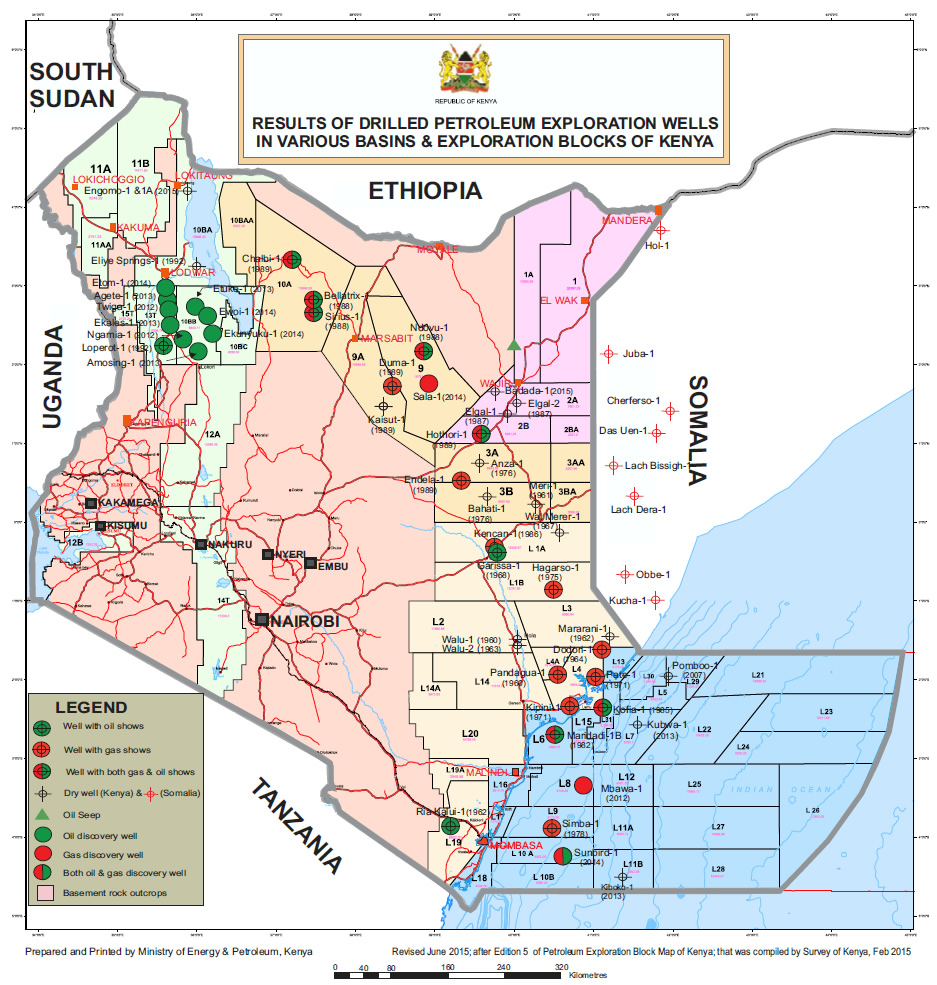
356Eni S.p.A., Press Release: Eni enters Kenya with the acquisition of three exploration block(2
July 2012). MS, Vol. IV, Annex 106. See also IHS Inc., EDIN Database, Kenya: Contracts Block
L21 (2015). MS, Vol. IV, Annex 135; IHS Inc., EDIN Database, Kenya: Contracts Block L23
(2015). MS, Vol. IV, Annex 136; IHS Inc., EDIN Database, Kenya: Contracts Block L24 (2015).
MS, Vol. IV, Annex 123.
357
Letter from Dr. Abdirahman D. Beileh, Ministry of Foreign Affairs & Investment Promotion of
the Federal Republic of Somalia, to Mr. Paolo Scaroni, Chief Executive Officer of Eni S.p.A., No.
MOFA/MO/1043/2014 (24 Apr. 2014), p. 1. MS, Vol. IV, Annex 74.
358See Kingdom of Norway, Ministry of Foreign Affairs, “Norway regrets claims by a UN report
linking Norwegian development efforts to commercial interests in Somalia” (25 July 2013). MS,
Vol. III, Annex 34. See Rawlings Otini, “Kenya expels oil giant Statoil from exploration plan”,
Business Daily Africa (5 Nov. 2012). MS, Vol. IV, Annex 109 . See also United Nations,
Monitoring Group on Somalia and Eritrea, Report of the Monitoring Group on Somalia and
Eritrea pursuant to Security Council resolution 2060 (2012): Somalia, U.N. Doc. S/2013/413 (12
July 2013), para. 28. MS, Vol. III, Annex 64.
138Kenya then awarded Lamu Oil and Gas Limited, a joint venture between the
Jordanian oil company Edgo and Qatar First Investment Bank, an exploration
359
licence in July 2012. The licence was, however, relinquished in January 2013
360
due to “the technical difficulties of drilling in [the block’s] very deep water”.
361
Thus, Block L-26 appears currently to be unlicensed.
8.26. The Kenyan government also authorised companies which are not
operators to undertake additional seismic activities in the disputed area. In 2008,
seismic data were acquired by PGS in association with t he National Oil
Corporation of Kenya, which included data relating to Block L -22. 362 In 2013-
2014, 2D seismic surveys were carried out in blocks L -21, L-22, L-23, L-24 and
363
L-26. These studies were carried out by Schlumberger, which was granted a
364
non-exclusive exploration licence. The Kenyan Government intends to use the
information thus acquired in order to fortify its position in the next licensing
359
IHS Inc., EDIN Database, Kenya: Contracts Block L26 (2015). MS, Vol. IV, Annex 124; Kelly
Gilblom, “Middle Eastern oil explorer gives up licence in Kenya”, Reuters (28 Jan. 2013). MS,
Vol. IV, Annex 112.
360Kelly Gilblom, “Middle Eastern oil explorer gives up licence in Kenya”, Reuters (28 Jan.
2013). MS, Vol. IV, Annex 112 ; IHS Inc., EDIN Database, Kenya: Contracts Block L 26 (2015).
MS, Vol. IV, Annex 124.
361See Nina Rach, “Kenyan explorers look deeper offshore”, oedigital.com (1 July 2014), p. 3.
MS, Vol. IV, Annex 120. See also Republic of Kenya, Ministry of Energy and Petroleum, Draft
National Energy And Petroleum Policy (20 Jan. 2015), Table 2-2. MS, Vol. III, Annex 29.
362 See Petroleum Geo -Services, “Kenya -Lamu Basin PGS MultiClient2D”, available at
http://www.pgs.com/pageFolders/241891/kenya_lamu_mc2d_a3ds_0412_std.pdf (last accessed 8
June 2015). MS, Vol. IV, Annex 129.
363
See Schlumberger, “Multiclient Latest Projects: Kenya Deepwater 2D 2013 Multiclient Seismic
Survey”, available at http://www.multiclient.slb.com/en/latest-projects/africa/kenya_2d.aspx (last
accessed 9 June 2015). MS, Vol. IV, Annex 130; Schlumberger, “Kenya Multiclient Seismic
Surveys: 2D offshore data”, available at http://www.multiclient.slb.com/africa/east-
africa/kenya.aspx (last accessed 9 June 2015). MS, Vol. IV, Annex 131 ; Schlumberger, “Kenya
Multiclient Seismic Surveys Map”, ava ilable at http://www.multiclient.slb.com/africa/east-
africa/kenya.aspx (last accessed 9 June 2015). MS, Vol. IV, Annex 132.
364See Hon. Davis Chirchir, Minister of Energy & Petroleum, Republic of Kenya, Speech: Official
Opening of the 5th East Africa, Oil, Gas and Energy Conference (29 Apr. 2014), p. 2. MS, Vol.
III, Annex 28.
139 365
negotiations. Moreover, it appears that, “[o]n the offshore L22 license, seabed
core drilling operations wer e carried out in early 2014 and a 3D seismic survey
366
was carried out”.
8.27. Thus, the Kenyan government itself has undertaken, or authorised private
companies to undertake, extensive seismic research in the disputed area, acquiring
information as to the nature, extent and economic viability of the potential
resources in the area. For its part, Somalia has protested against this illegal
367
exploration in maritime areas it claims as its own. It has also ordered the
368
companies involved to cease their activities, though several have refused to do
369
so.
365
See John Gachiri, “National Oil, American firm finish survey of Lamu oil blocks”, Business
Daily (2 Dec. 2014). MS, Vol. IV, Annex 122.
366
Total S.A., Factbook 2014 (2014), p. 81. MS, Vol. IV, Annex 117.
367
See Kelly Gilblom, “Kenya, Somalia border row threatens oil exploration”, Reuters (20 Apr.
2012). MS, Vol. IV, Annex 104; and Kelly Gilblom, “Somalia challenges Kenya over oil blocks”,
Reuters (6 July 2012). MS, Vol. IV, Annex 107.
368
See Letter from Dr. Abdirahman D. Beileh, Ministry of Foreign Affairs & Investment
Promotion of the Federal Republic of Somalia, to Mr. Paolo Scaroni, Chief Executive Officer of
Eni S.p.A., No. MOFA/MO/1043/2014 (24 Apr. 2014). MS, Vol. IV, Annex 74; Let ter from H.E.
Ahmed Ali Dahir, Attorney-General of the Federal Republic of Somalia, to Mr. Claudio Descalzi,
Chief Executive Officer of Eni S.p.A., No. 01/115/XIG/2014 (16 Sept. 2014). MS, Vol. IV, Annex
76; Letter from H.E. Ahmed Ali Dahir, Attorney -General of the Federal Republic of Somalia, to
Mr. Peter Worthington, Chief Executive Officer of Midway Resources International, No.
02/124/XIG/2014 (20 Sept. 2014). MS, Vol. IV, Annex 77; Letter from H.E. Ahmed Ali Dahir,
Attorney-General of the Federal Republ ic of Somalia, to Mr. Christophe de Margerie, Chief
Executive Officer of Total S.A., No. 03/125/XIG/2014 (20 Sept. 2014). MS, Vol. IV, Annex 78.
369
See Letter from Mr. Massimo Mantovani, Senior Executive Vice President, General Counsel
Legal Affairs Department, Eni S.p.A., to H.E. Abdirahman D. Beileh, Minister of Foreign Affairs
of the Federal Republic of Somalia, No. Prot. Dialeg 10 (9 June 2014). MS, Vol. IV, Annex 75;
Letter from Mr. Claudio Descalzi, Chief Executive Officer of Eni S.p.A., to H.E. Abdira hman D.
Beileh, Minister of Foreign Affairs of the Federal Republic of Somalia, and H.E. Ahmed Ali
Dahir, Attorney-General of the Federal Republic of Somalia, No. 85 (3 Oct. 2014). MS, Vol. IV,
Annex 79.
1408.28. Kenya’s unilateral activities “no doubt, raise a question of infringement of
[Somalia’s] exclusive right of exploration” 370 and engage Kenya’s international
responsibility. The envisaged drilling in view of the exploitation of the resources
of the continental shelf and, possibly, of the territorial sea, would a fortiori entail
Kenya’s responsibility.
Section III. Consequences of Kenya’s Responsibility
371
8.29. The obligation of cessation of the wrongful act is the first of the
consequences triggered by Kenya’s violation of Somalia’s exclusive rights of
exploration. The acquisition and retention of data is a continuing violation of an
international obligation. In cases where the wrongful a ct consists of the acquiring
and continuing possession and analysis of confidential data, as well as its
transmission to third parties (like the oil companies interested in the exploitation
of maritime areas), restitutio in integrum is not possible. As the Court said in its
provisional measures Order of 3 March 2014 in the Certain Documents and Data
case between Timor-Leste and Australia,
“Any breach of confidentiality may not be capable
of remedy or reparation as it might not be possible
370Greece v. Turkey, para. 31. See also supra paras. 8.8-8.15.
371
See Article 30 of th e ILC’s Articles on Responsibility of States for Internationally Wrongful
Acts:
“Cessation and non-repetition
The State responsible for the internationally wrongful act is under an obligation:
(a) to cease that act, if it is continuing;
(b) to offer appr opriate assurances and guarantees of non -repetition, if
circumstances so require”.
International Law Commission, Commentary on the Draft Articles on Responsibility of States for
Internationally Wrongful Acts , in Report of the International Law Commission on the work of its
fifty-third session (23 Apr-1 June and 2 July -10 August 2001) , in Y EARBOOK OF THE
INTERNATIONAL L AW C OMMISSION , Vol. II, Part 2 (2001), p. 88. MS, Vol. III, Annex 54.
141 to revert to the status quo ante following disclosure
of the confidential information”. 372
8.30. It is therefore not sufficient for Kenya to cease collection of seismic data,
after the Court has delivered its judgment on delimitation. Kenya must also be
ordered to deliver to Somalia all the data it has acquired in relation to portions of
the disputed area that are finally recognized as pertaining to Somalia. Kenya must
also be ordered not to further disseminate the data thus acquired and to take all
necessary measures in order to p revent the companies that undertook the surveys
from disseminating this data. If, during the present proceedings, Somalia has
reason to believe that Kenya is acting contrary to this duty, it reserves its right to
request provisional measures indicating tha t Kenya must refrain from such
activities.
8.31. In the same vein, it must be recalled that as indicated in Article 29 of the
ILC Articles on the Responsibility of States for Internationally Wrongful Acts
(Continued duty of performance):
“The legal consequences of an internationally
wrongful act under this part do not affect the
continued duty of the responsible State to perform
the obligation breached”.
This is true in the present case, and indeed Kenya cannot take shelter behind the
fact that the Court has not yet decided on the maritime boundary between the
Parties to continue to breach its duty not to create a fait accompli in the disputed
area.
372Questions relating to the seizure and detention of Certain Document s and Data (Timor-Leste v.
Australia), Request for the Indication of Provisional Measures, Order of 3 March 2014, I.C.J.,
para. 42. See also Ghana/Côte d’Ivoire, paras. 47, 92.
1428.32. This also applies during the duration of the present proceedings: Kenya
continues to develop its strategy of explora tion in the area, to grant concessions,
to undertake seismic studies and even to conduct drilling operations, 373 despite
being well aware of Somalia’s claim. In so doing, it not only breaches Somalia’s
sovereign rights, but it also aggravates the dispute tha t has been submitted to the
Court for decision.
8.33. It also goes without saying that in the event Kenya’s activities affect
Somalia’s rights in a permanent manner, the former “is under an obligation to
make full reparation for the injury caused by the internat ionally wrongful act”. 374
In the present case, restitution —which “is the first of the forms of reparation
available to a State injured by an internationally wrongful act” 375—is hardly
practicable. The Special Chamber of ITLOS recently underscored:
“Considering that, whatever its nature, any
compensation awarded would never be able to
restore the status quo ante in respect of the seabed
and subsoil; …
Considering that the acquisition and use of
information about the resources of the disputed area
would create a risk of irreversible prejudice to the
rights of Côte d’Ivoire should the Special Chamber,
in its decision on the merits, find that Côte d’Ivoire
has rights in all or any part of the disputed area;
373
See, supra, paras. 8.19-8.28.
374
ILC, Commentary on the Draft Articles on Responsibility of States for Internationally Wrongful
Acts, in YARBOOK OF THE INTERNATIONAL LAW COMMISSION , Vol. II, Part 2 (2001), Art. 31(1).
MS, Vol. III, Annex 54. See also Case Concerning the Factory at Chorzów, Merits, Judgment,
1928, P.C.I.J. Series A, No. 17 , p. 47; Pulp Mills on the River Uruguay (ArgenUruguay),
Judgment, I.C.J. Reports 2010, para. 273.
375
ILC, Commentary on the Draft Articles on Responsibility of States for Internationally Wrongful
Acts, in YARBOOK OF THE INTERNATIONAL L AW C OMMISSION , Vol. II, Part 2 (2001), Art. 35
Commentary, para. 1. MS, Vol. III, Annex 54.
143 Considering therefore that the exploration and
exploitation activities, as planned by Ghana, may
cause irreparable prejudice to the sovereign and
exclusive rights invoked by Côte d’Ivoire in the
continental shelf an376uperjacent waters of the
disputed area …”.
8.34. As a result, “insofar as” the damage caused by Keny a’s internationally
wrongful acts cannot be “made good by restitution”, it is “under an obligation to
compensate for the damage”. 377 Compensation would, of course, be the only
means of reparation if Kenya extracts, or authorizes extraction of, oil within thi s
area before the end of the present proceedings. 378 The same would hold true in
case Kenya continues to encourage or authorize fisheries in the maritime area
under Somalia’s jurisdiction.
8.35. Accordingly, Somalia requests the Court to adjudge and declare that
Kenya, by its conduct, has engaged its international responsibility and that
compensation is due to Somalia for the damage thus caused. Somalia reserves the
right subsequently to claim compensation for elements of unjust enrichment
376
Ghana/Côte d’Ivoire, paras. 90, 95-96.
377ILC, Commentary on the Draft Articles on Responsibility of States for Internationally Wrongful
Acts, in YARBOOK OF THE NTERNATIONAL LAW C OMMISSION , Vol. II, Part 2 (2001), Art. 36(1).
MS, Vol. III, Annex 54. See also Case Concerning the Factory at Chorzów, Merits, Judgment,
1928, P.C.I.J. Series A, No. 17 , pp. 47 -48; Gabčíkovo-Nagymaros Project (Hungary/Slovakia),
Judgment, I.C.J. Reports 1997, para. 152; Ahmadou Sadio Diallo (Republic of Guinea v.
Democratic Republic of the Congo) , Compensation owed by the Democratic Republic of the
Congo to the Republic of Guinea, Judgment, I.C.J. Reports 2012, para. 13; The M/V “Saiga” (No.
2) Case (Saint Vincent and the Grenadines v . Guinea), Judgment of 1 July 1999, ITLOS Reports
1999, para. 170.
378See Ghana/Côte d’Ivoire, para. 88; Guyana v. Suriname, paras. 465-470.
144consequent upon Kenya’s unlawful conduct in Somalia’s sovereign maritime
379
areas and for the financial damages it has suffered.
379Gabčíkovo-Nagymaros Project (Hungary/Slovakia), Judgment, I.C.J. Reports 1997, paras. 151-
154; Ahmadou Sadio Diallo (Republic of Guinea v. Democratic Republic of the Congo) , Merits,
Judgment, I.C.J. Reports 2010, paras. 160-164.
145146 SUBMISSIONS
On the basis of the facts and law set forth in this Memorial, Somalia respectfully
requests the Court:
1. To determine the complete course of the maritime boundary between
Somalia and Kenya in the Indian Ocean, including in the continental shelf
beyond 200 M, on the basis of international law.
2. To determine the maritime boundary between Somalia and Kenya in the
Indian Ocean on the basis of the following geographical coordinates:
Point No. Latitude Longitude
1 1°39’44.07” S 41°33’34.57” E
(LBT)
2 1°40’05.92” S 41°34’05.26” E
3 1°41’11.45” S 41°34’06.12” E
4 1°43’09.34” S 41°36’33.52” E
5 1°43’53.72” S 41°37’48.21” E
6 1°44’09.28” S 41°38’13.26” E
7 1°47’54.60” S 41°43’36.04” E
(intersection with
12 M limit)
8 2°19’01.09” S 42°28’10.27” E
9 2°30’56.65” S 42°46’18.90” S
10 3°34’57.05” S 44°18’49.83” E
(intersection with
200 M limit)
11 5°00’25.71” S 46°22’33.36” E
(intersection with
350 M limit)
1473. To adjudge and declare that Kenya, by its conduct in the disputed area, has
violated its international obligations to respect the sovereignty, and
sovereign rights and jurisdiction of Somalia, and is responsible under
international law to make full reparation to Somalia, including inter alia by
making available to Somalia all seismic data acquired in areas that are
determined by the Court to be subject to the sovereignty and/or sovereign
rights and jurisdiction of Somalia, and to repair in full all damage t hat has
been suffered by Somalia by the payment of appropriate compensation.
(All points referenced are referred to WGS-84)
148 VOLUME I
FIGURES
Figure 1.1 The Parties’ Coasts Abutting the Area to following page 8
Be Delimited
Figure 2.1 The General Geographical Setting following page 16
Figure 2.2 Somalia’s Ras Kaambooni and Diua following page 18
Damasciaca Islands
Figure 2.3 The Somali Basin following page 24
Figure 3.3 Kenya’s Parallel Boundary Claim following page 34
Compared to Equidistance
Figure 3.5A Excerpt from 1978 Map Published by following page 36
Petroconsultants, S.A.
Figure 3.5B Boundary from the 1978 Petroconsultants following page 36
Map Compared to Equidistance
Figure 3.7 Kenya’s Off-Shore Oil Concession Blocks following Figures
3.5A & 3.5B
Figure 4.2 Map Prepared by the Anglo-Italian following page 58
Boundary Commission (1925-1927)
Figure 4.3 Expected Location of Primary Beacon following Figure
No. 29 4.3
Figure 4.4 The Land Boundary Terminus on the following page 60
Parties’ Low-Tide Coast
Figure 5.1 Delimitation of the Territorial Sea Using following page 68
Equidistance
Figure 5.2 The Parallel Resulting from the following page 72
Coordinates Specified in Kenya’s 2005
Presidential ProclamationFigure 5.3 Kenya’s Parallel Boundary Claim Line following page 74
Extending East From the Land Boundary
Terminus
Figure 6.1 The Equidistance Line following page 76
Figure 6.6 Somalia’s Relevant Coast following page 86
Figure 6.7 Kenya’s Relevant Coast following Figure
6.6
Figure 6.8 Overlapping Potential Entitlements following page 88
Within 200 M
Figure 6.9 Overlapping Potential Entitlements following Figure
Within and Beyond 200 M 6.8
Figure 6.10 Equidistance Base Points following page 90
Figure 6.11 The Equidistance Line Produces Its following page 94
Effects in a Reasonable, Mutually
Balanced Fashion
Figure 6.12 Division of Overlapping Potential following page 96
Entitlements Within 200 M Using
Equidistance
Figure 6.13 Division of Overlapping Potential following Figure
Entitlements Within 200 M Using 6.12
Kenya’s Parallel Claim
Figure 7.1 The Limit of Somalia’s Continental Shelf following page
as Submitted to the CLCS 112
Figure 7.2 The Limit of Kenya’s Continental Shelf as following Figure
Submitted to the CLCS 7.1
Figure 7.3 Outer Continental Shelf Claims of following Figure
Somalia and Kenya 7.2
Figure 7.4 Overlap Between Somalia’s EEZ and following page
Kenya’s Claim Beyond 200 M 114Figure 7.6 Somalia’s Coastal Projection Is Cut-Off following page
by Kenya’s Proposal 118
Figure 7.7 Any Cut-Off Kenya Suffers Is a Result of following Figure
Its Agreement with Tanzania 7.6
Figure 7.8 Equidistance Would Have Provided following page
Kenya a Much Larger Area of the 122
Continental Shelf Beyond 200 M
Figure 7.9 The Non-Disproportionality Test Based following page
on Equidistance 124
Figure 7.10 The Non-Disproportionality Test Based following Figure
on Kenya’s Parallel Claim 7.9
Figure 7.11 Equidistance Beyond 200 M Avoids Any following Figure
Overlap with Tanzania’s Potential 7.10
Entitlements
Figure 8.1 Kenya’s Off-Shore Oil Concession Blocks following page
136 LIST OF ANNEXES
VOLUME II
FIGURES
All maps are for illustrative purposes only
Figure 1.1 The Parties’ Coasts Abutting the Area to Be Delimited
Figure 2.1 The General Geographical Setting
Figure 2.2 Somalia’s Ras Kaambooni and Diua Damasciaca Islands
Figure 2.3 The Somali Basin
Figure 3.1 Somalia’s Straight Baselines Along the Fringing Baajuun
Islands
Figure 3.2 Kenya’s Straight Baselines, as Amended (2005)
Figure 3.3 Kenya’s Parallel Boundary Claim Compared to Equidistance
Figure 3.4 Kenya’s Agreed Boundary with Tanzania
Figure 3.5A Excerpt from 1978 Map Published by Petroconsultants, S.A.
Figure 3.5B Boundary from the 1978 Petroconsultants Map Compared to
Equidistance
Figure 3.6 Limit of the Jorre Offshore Block as Depicted on the 2002
IHS Somalia Map Compared to Equidistance
Figure 3.7 Kenya’s Off-Shore Oil Concession Blocks
Figure 4.1 Map Attached to the 1924 Treaty
Figure 4.2 Map Prepared by the Anglo-Italian Boundary Commission
(1925-1927)
Figure 4.3 Expected Location of Primary Beacon No. 29
Figure 4.4 The Land Boundary Terminus on the Parties’ Low-Tide CoastFigure 5.1 Delimitation of the Territorial Sea Using Equidistance
Figure 5.2 The Parallel Resulting from the Coordinates Specified in
Kenya’s 2005 Presidential Proclamation
Figure 5.3 Kenya’s Parallel Boundary Claim Line Extending East From
the Land Boundary Terminus
Figure 6.1 The Equidistance Line
Figure 6.2 Sketch-Map 4 from the ICJ Judgment in Romania v. Ukraine
(3 February 2009)
Figure 6.3 Sketch-Map 6 from the ICJ Judgment in Nicaragua v.
Colombia (19 November 2012)
Figure 6.4 Sketch-Map 3 from the ITLOS Judgment in Bangladesh v.
Myanmar (14 March 2012)
Figure 6.5 Sketch-Map 4 from the Arbitral Tribunal’s Award in
Bangladesh v. India (7 July 2014)
Figure 6.6 Somalia’s Relevant Coast
Figure 6.7 Kenya’s Relevant Coast
Figure 6.8 Overlapping Potential Entitlements Within 200 M
Figure 6.9 Overlapping Potential Entitlements Within and Beyond 200 M
Figure 6.10 Equidistance Base Points
Figure 6.11 The Equidistance Line Produces Its Effects in a Reasonable,
Mutually Balanced Fashion
Figure 6.12 Division of Overlapping Potential Entitlements Within 200 M
Using Equidistance
Figure 6.13 Division of Overlapping Potential Entitlements Within 200 M
Using Kenya’s Parallel Claim
Figure 7.1 The Limit of Somalia’s Continental Shelf as Submitted to the
CLCSFigure 7.2 The Limit of Kenya’s Continental Shelf as Submitted to the
CLCS
Figure 7.3 Outer Continental Shelf Claims of Somalia and Kenya
Figure 7.4 Overlap Between Somalia’s EEZ and Kenya’s Claim Beyond
200 M
Figure 7.5 Intersection of the Equidistance Line with Somalia’s 350 M
Limit
Figure 7.6 Somalia’s Coastal Projection Is Cut-Off by Kenya’s Proposal
Figure 7.7 Any Cut-Off Kenya Suffers Is a Result of Its Agreement with
Tanzania
Figure 7.8 Equidistance Would Have Provided Kenya a Much Larger
Area of the Continental Shelf Beyond 200 M
Figure 7.9 The Non-Disproportionality Test Based on Equidistance
Figure 7.10 The Non-Disproportionality Test Based on Kenya’s Parallel
Claim
Figure 7.11 Equidistance Beyond 200 M Avoids Any Overlap with
Tanzania’s Potential Entitlements
Figure 7.12 Area of Continental Shelf Within Somalia’s OCS Limit and
South of Kenya’s OCS Claim
Figure 8.1 Kenya’s Off-Shore Oil Concession Blocks MAPS
Annex M1 Petroconsultants S.A., Kenya (Coastal Area): Synopsis 1978
(Including Current Activity) (Jan. 1979)
Annex M2 Petroconsultants S.A., Kenya (Coastal Area): Synopsis 1979
(Feb. 1980)
Annex M3 Petroconsultants S.A., Kenya (Coastal Area): Synopsis 1982
(Jan. 1983)
Annex M4 Petroconsultants S.A., Kenya: Synopsis 1984 (Jan. 1985)
Annex M5 Petroconsultants S.A., Kenya: Synopsis 1985 (Including
Current Activity) (Apr. 1986)
Annex M6 Petroconsultants S.A., Kenya: Synopsis 1994 (Jan. 1995)
Annex M7 Petroconsultants S.A., Kenya: Synopsis 1995 (July 1996)
Annex M8 Petroconsultants S.A., Kenya: Current Status & Synopsis 1996
(June 1997)
Annex M9 IHS Energy Group, Global Exploration & Production Service:
Somalia (Mar. 2002)
Annex M10 IHS Inc., Valid Blocks as of 1 January 2000 [Kenya] (June
2015)
Annex M11 IHS Inc., Valid Blocks as of 1 January 2001 [Kenya] (June
2015) VOLUME III
EXHIBITS
TREATIES & AGREEMENTS
Annex 1 Protocol between the British and Italian Governments for the
Demarcation of their respective Spheres of Influence in Eastern
Africa, from the River Juba to the Blue Nile (24th March,
1891), reprinted inheM ap ofa frica bT reaTy, Vol. II (E.
Hertslet, ed., 1896)
Annex 2 Treaty between Italy and the United Kingdom regulating
certain Questions concerning the Boundaries of their
Respective Territories in EastAfrica, signed at London (15
July 1924), and Exchange of Notes defining a Section of the
said Boundaries, Rome, (16 & 26 June 1925), 35 L.N.T.S. 380
(1925)
Annex 3 Agreement between Italy and the United Kingdom in which
are recorded the decisions of the Commission appointed under
Article 12 of the Treaty between His Britannic Majesty and His
Majesty the King of Italy, signed at London on July 15, 1924,
regulating certain questions concerning the boundaries of their
respective territories in EastAfrica (17 Dec. 1927)
Annex 4 Exchange of Notes between His Majesty’s Government in the
United Kingdom and the Italian Government regarding the
Boundary between Kenya and Italian Somaliland (22 Nov.
1933), U.K.T.S. No. 1, Cmd. 4491 (1934)
Annex 5 Exchange of Notes Constituting anAgreement between the
Republic of Kenya and the United Republic of Tanzania on the
Territorial Sea Boundary, 1039 U.N.T.S. 148 (17 Dec. 1975 &
9 July 1976), entered into force 9 July 1976Annex 6 Memorandum of Understanding between the Government
of the Republic of Kenya and the Transitional Federal
Government of the Somali Republic to Grant to Each Other
No-Objection in Respect of Submissions on the Outer Limits
of the Continental Shelf beyond 200 Nautical Miles to the
Commission on the Limits of the Continental Shelf, 2599
U.N.T.S. 35 (7Apr. 2009), entered into force 7Apr. 2009
Annex 7 Agreement between the United Republic of Tanzania and
the Republic of Kenya on the delimitation of the maritime
boundary of the exclusive economic zone and the continental
shelf, 2603 U.N.T.S. 37 (23 June 2009), entered into force 23
June 2009
Annex 8 United Nations Treaty Collection, Status of the Convention
on the Territorial Sea and the Contiguous Zone, Declarations
and Reservations, available at https://treaties.un.org/doc/
Publication/MTDSG/Volume%20II/Chapter%20XXI/XXI-1.
en.pdf
SOMALI LEGISLATION
Annex 9 Somali Democratic Republic, Law No. 37, Law on the Somali
Territorial Sea and Ports (10 Sept. 1972)
Annex 10 Somali Democratic Republic, Ministry of Fisheries and Sea
Transport, Somali Maritime Law (1988)
Annex 11 Somali Democratic Republic, Law No. 5, Somali Maritime
Law (26 Jan. 1989)
Annex 12 Somali Democratic Republic, Presidential Decree No. 14,
Instrument of Ratification (9 Feb. 1989)
Annex 13 Somali Democratic Republic, Law No. 11, Mandate-the
Approval of the Third United Nations Maritime Law (9 Feb.
1989)Annex 14 Federal Republic of Somalia, Office of the President,
Proclamation by the President of the Federal Republic of
Somalia (30 June 2014)
Annex 15 Federal Republic of Somalia, Outer Limit of the Exclusive
Economic Zone of Somalia (30 June 2014)
KENYAN LEGISLATION
Annex 16 Republic of Kenya, Law No. 2 of 1972, Territorial Waters Act
(16 May 1972)
Annex 17 Republic of Kenya, Territorial Waters Act (16 May 1972, as
revised in 1977)
Annex 18 Republic of Kenya, Approximate Co-ordinates of Baseline
Points on Map Sheet SK/74 (28 Feb. 1979)
Annex 19 Republic of Kenya, Presidential Proclamation of 28 February
1979 (28 Feb. 1979)
Annex 20 Republic of Kenya, Chapter 371, Maritime Zones Act (25 Aug.
1989)
Annex 21 Republic of Kenya, Legal Notice No. 82, Proclamation by the
President of the Republic of Kenya (9 June 2005), published in
Kenya Gazette Supplement No. 55 (Legislative Supplement No.
34) (22 July 2005)
Annex 22 Republic of Kenya, Deposit by the Republic of Kenya to the
United Nations of lists of geographical coordinates of points,
pursuant to article 16, paragraph 2, and article 75, paragraph
2 of the Convention, together with Illustrative map number SK
90 and the Proclamation by the President of the Republic of
Kenya of 9 June 2005 (11Apr. 2006)
Annex 23 Republic of Kenya, Laws of Kenya, Chapter 2, The
Interpretation and General Provisions Act (1983, revised ed.
2008) SOMALI GOVERNMENT DOCUMENTS
Annex 24 Federal Republic of Somalia, Report on the Meeting between
The Federal Republic of Somalia and The Republic of Kenya
On Maritime Boundary Dispute, Nairobi, Kenya, 26-27 March
2014 (1Apr. 2014)
KENYAN GOVERNMENT DOCUMENTS
Annex 25 National Oil Company of Kenya, Kenya Exploration Blocks
(2006), available at http://www.nationaloil.co.ke/image/
blockstatus.jpg
Annex 26 Republic of Kenya, NationalAssembly, Official Report (24
Apr. 2007)
Annex 27 Republic of Kenya, NationalAssembly, Official Report (8 Aug.
2007)
Annex 28 Hon. Davis Chirchir, Minister of Energy & Petroleum,
Republic of Kenya, Speech: Official Opening of the 5th East
Africa, Oil, Gas and Energy Conference (29Apr. 2014)
Annex 29 Republic of Kenya, Ministry of Energy and Petroleum, Draft
National Energy And Petroleum Policy (20 Jan. 2015)
Annex 30 National Oil Company of Kenya, “Oil and Gas Exploration
History in Kenya”, available at http://nationaloil.co.ke/site/3.
php?id=1 (last accessed 10 June 2015)
JOINT SOMALIA-KENYAREPORTS
Annex 31 Government of Somalia and Government of Kenya, Joint
Report on the Kenya-Somali Maritime Boundary Meeting, 26-
27 Mar. 2014 (1Apr. 2014)
Annex 32 Government of Somalia and Government of Kenya, Joint
Report on the Kenya-Somalia Maritime Boundary Meeting, 28-
29 July 2014 (July 2014) THIRD-PARTY GOVERNMENT DOCUMENTS
Annex 33 Government of the United Kingdom and Government of Italy,
Minutes of the Twenty-First Meeting (17 Dec. 1927)
Annex 34 Kingdom of Norway, Ministry of ForeignAffairs, “Norway
regrets claims by a UN report linking Norwegian development
efforts to commercial interests in Somalia” (25 July 2013)
DIPLOMATIC CORRESPONDENCE
Annex 35 Note Verbale from the Permanent Mission of Somali
Democratic Republic to the United Nations to the Secretary-
General of the United Nations, No. NY/UN-20/490/89 (20 July
1989)
Annex 36 Note Verbale from the Secretary-General of the United Nations
to the Permanent Representative of the Somali Democratic
Republic to the United Nations, No. LA41 TR/221/1 (21-6) (8
Aug. 1989)
Annex 37 Letter from H.E. OmarAbdirashidAli Sharmarke, Prime
Minister of the Transitional Federal Government of the Somali
Republic, to H.E. Ban Ki-Moon, Secretary-General of the
United Nations, No. XRW/00506/08/09 (19Aug. 2009)
Annex 38 Letter from H.E. OmarAbdirashidAli Sharmarke, Prime
Minister of the Transitional Federal Government of the Somali
Republic, to H.E. Ban Ki-Moon, Secretary-General of the
United Nations, No. OPM/IC/00./016/11/09 (10 Oct. 2009)
Annex 39 Letter from Dr. ElmiAhmed Duale, Permanent Representative
of the Permanent Mission of the Somali Republic to the United
Nations, to H.E. Ban Ki-Moon, Secretary-General of the
United Nations, No. SOM/MSS/09/10 (2 Mar. 2010)
Annex 40 Note Verbale from the Permanent Mission of the Republic of
Kenya to the United Nations to the Secretary-General of the
United Nations, No. 7/14 (9 Jan. 2014)Annex 41 Letter from Dr.Abdirahman Beileh, Minister of Foreign
Affairs and International Cooperation of the Somali Federal
Republic, to H.E. Ban Ki-Moon, Secretary-General of the
United Nations, No. MOFA/SFR/MO/259/2014 (4 Feb. 2014)
Annex 42 Letter from Dr.Abdirahman Beileh, Minister of Foreign
Affairs and International Cooperation of the Somali Federal
Republic, to H.E. Ban Ki-Moon, Secretary-General of the
United Nations, No. MOFA/SFR/MO/258/2014 (4 Feb. 2014)
Annex 43 Letter from H.E. Dr.Abdirahman Beileh, Minister of Foreign
Affairs and International Cooperation of the Federal Republic
of Somalia, to H.E. Ms.Amina Mohamed, Minister of Foreign
Affairs & International Trade of the Republic of Kenya, No.
MOFA/SER/MO/ /2014 (13 Mar. 2014)
Annex 44 Note Verbale from the Ministry of ForeignAffairs and
International Trade of the Republic of Kenya to the Ministry
of ForeignAffairs and Investment Promotion of the Federal
Republic of Somalia, No. MFA. PROT 7/17AVOL. IV(18) (11
July 2014)
Annex 45 Note Verbale from the Ministry of ForeignAffairs and
International Trade of the Republic of Kenya to the Embassy
of the Federal Republic of Somalia in Nairobi, No. MFA.TCA
12/34 Vol. XI (109) (13Aug. 2014) enclosing Note Verbale
from the Ministry of ForeignAffairs and International Trade of
the Republic of Kenya to the Ministry of ForeignAffairs and
Investment Promotion of the Federal Republic of Somalia, No.
MFA. TCA12/34 Vol. XI (110) (13Aug. 2014)
Annex 46 Exchange of Emails between Ms. MonaAl-Sharmani, Special
Adviser to the President of the Federal Republic of Somalia,
and Ms. Juster Nkoroi, Republic of Kenya (6-16Aug. 2014)
Annex 47 Letter from H.E. Dr.Abdirahman Beileh, Minister of Foreign
Affairs and Investment Promotion of the Federal Republic of
Somalia, to Ms. Amina Mohamed, Minister of Foreign Affairs
of the Republic of Kenya, No. 2231 (26Aug. 2014)Annex 48 Letter from the Permanent Mission of the Somali Republic to
the United Nations to H.E. Ban Ki-Moon, Secretary-General of
the United Nations, No. SOM/MSS/253/14 (2 Sept. 2014)
Annex 49 Note Verbale from the Permanent Mission of the United
Republic of Tanzania to the United Nations to the Commission
on the Limits of the Continental Shelf, No. TZNY/P.60/2 (17
Oct. 2014)
Annex 50 Note Verbale from the Permanent Mission of the Republic of
Kenya to the United Nations to H.E. Ban Ki-Moon, Secretary-
General of the United Nations, No. 586/14 (24 Oct. 2014)
Annex 51 Note Verbale from the Permanent Mission of the Republic of
Kenya to the United Nations to H.E. Ban Ki-Moon, Secretary-
General of the United Nations, No. 141/15 (4 May 2015)
Annex 52 Letter from H.E.Abdulsalam H. Omer, Minister of Foreign
Affairs and Investment Promotion of the Federal Republic
of Somalia, to H.E. Ban Ki-Moon, Secretary-General of the
United Nations (7 July 2015)
UNITED NATIONS & U.N. COMMISSION ON
THE LIMITS OFTHE CONTINENTALSHELF
DOCUMENTS
Annex 53 Memorandum from the Secretary-General of the United
Nations to Treaty Services of Ministries of ForeignAffairs and
of international organizations concerned, No. C.N.187.1989.
TREATIES-2 (28Aug. 1989)
Annex 54 International Law Commission, Commentary on the Draft
Articles on Responsibility of States for Internationally
Wrongful Acts, in Report of the International Law Commission
on the work of its fifty-third session (23 April-1 June and 2
July-10 August 2001), iearbook of TheinTernaTional law
coMMission, Vol. II, Part 2 (2001)Annex 55 U.N. Convention on the Law of the Sea, Meeting of States
Parties, Eleventh Meeting, Decision regarding the date of
commencement of the ten-year period for making submissions
to the Commission on the Limits of the Continental Shelf set
out in article 4 of Annex II to the United Nations Convention
on the Law of the Sea, U.N. Doc. SPLOS/72 (29 May 2001)
Annex 56 United Nations, Division for OceanAffairs and the Law of the
Sea, Deposit by the Republic of Kenya of lists of geographical
coordinates of points, pursuant to article 16, paragraph 2, and
article 75, paragraph 2, of the Convention, U.N. Doc. M.Z.N.
58.2006.LOS (25Apr. 2006)
Annex 57 United Nations, Commission on the Limits of the Continental
Shelf, Rules of Procedure of the Commission on the Limits
of the Continental Shelf, U.N. Doc. CLCS/40/Rev.1 (17Apr.
2008)
Annex 58 U.N. Convention on the Law of the Sea, Meeting of States
Parties, Eighteenth Meeting, Decision regarding the workload
of the Commission on the Limits of the Continental Shelf and
the ability of States, particularly developing States, to fulfil
the requirements of article 4 of annex II to the United Nations
Convention on the Law of the Sea, as well as the decision
contained in SPLOS/72, paragraph (a), U.N. Doc. SPLOS/183
(20 June 2008)
Annex 59 Republic of Kenya, Submission on the Continental Shelf
Submission beyond 200 nautical miles to the Commission on
the Limits of the Continental Shelf: Executive Summary (Apr.
2009)
Annex 60 United Nations, Division for OceanAffairs and the Law of the
Sea, Receipt of the submission made by the Republic of Kenya
to the Commission on the Limits of the Continental Shelf, U.N.
Doc. CLCS.35.2009.LOS (11 May 2009)
Annex 61 United Nations, Commission on the Limits of the Continental
Shelf, Statement by the Chairman of the Commission on the
Limits of the Continental Shelf on the progress of work of the
Commission, U.N. Doc. CLCS/64 (1 Oct. 2009)Annex 62 United Republic of Tanzania, Partial Submission on
the Continental Shelf beyond 200 Nautical Miles to the
Commission on the Limits of the Continental Shelf Pursuant to
Part VI of and Annex II to the United Nations Convention on
the Law of the Sea 1982: Executive Summary (18 Jan. 2012)
Annex 63 United Nations, Commission on the Limits of the Continental
Shelf, Progress of work in the Commission on the Limits of the
Continental Shelf: Statement by the Chair, U.N. Doc. CLCS/76
(5 Sept. 2012)
Annex 64 United Nations, Monitoring Group on Somalia and Eritrea,
Report of the Monitoring Group on Somalia and Eritrea
pursuant to Security Council resolution 2060 (2012): Somalia,
U.N. Doc. S/2013/413 (12 July 2013)
Annex 65 United Nations, Commission on the Limits of the Continental
Shelf, Progress of work in the Commission on the Limits of the
Continental Shelf: Statement by the Chair, U.N. Doc. CLCS/83
(31 Mar. 2014)
Annex 66 Federal Republic of Somalia, Preliminary Information
Indicative of the outer limits of the continental shelf and
Description of the status of preparation of making a
submission To the Commission on the Limits of the Continental
Shelf for Somalia (14Apr. 2009)
Annex 67 Federal Republic of Somalia, Appendix 1: Figures, submitted
with Preliminary Information Indicative of the outer limits
of the continental shelf and Description of the status of
preparation of making a submission To the Commission on the
Limits of the Continental Shelf for Somalia (14Apr. 2009)
Annex 68 United Nations, Division for OceanAffairs and the Law of
the Sea, Deposit by the Federal Republic of Somalia of a list
of geographical coordinates of points, pursuant to article 16,
paragraph 2 and article 75, paragraph 2 of the Convention,
U.N. Doc. M.Z.N. 106.2014.LOS (3 July 2014)Annex 69 United Nations, Receipt of the submission made by the Federal
Republic of Somalia to the Commission on the Limits of the
Continental Shelf, U.N. Doc. CLCS.74.2014.LOS (21 July
2014)
VOLUME IV
EXHIBITS
UNITED NATIONS & U.N. COMMISSION ON
THE LIMITS OFTHE CONTINENTALSHELF
DOCUMENTS
Annex 70 Federal Republic of Somalia, Continental Shelf Submission of
the Federal Republic of Somalia: Executive Summary (21 July
2014)
Annex 71 United Nations, Commission on the Limits of the Continental
Shelf, Progress of work in the Commission on the Limits of the
Continental Shelf: Statement by the Chair, U.N. Doc. CLCS/85
(24 Sept. 2014)
Annex 72 United Nations, Office of LegalAffairs, Division for Ocean
Affairs and the Law of the Sea, Table recapitulating the status
of the Convention and of the related Agreements (10 Oct.
2014), available at http://www.un.org/depts/los/reference_
files/status2010.pdf
Annex 73 United Nations, Statistics Division, NationalAccounts Main
Aggregates Database, “Per Capita GDP in US Dollars” (Dec.
2014), available at http://unstats.un.org/unsd/snaama/dnllist.
asp (last accessed 26 June 2015) CORRESPONDENCE BETWEEN SOMALIAAND
PETROLEUM COMPANIES
Annex 74 Letter from Dr.Abdirahman D. Beileh, Ministry of Foreign
Affairs & Investment Promotion of the Federal Republic of
Somalia, to Mr. Paolo Scaroni, Chief Executive Officer of Eni
S.p.A., No. MOFA/MO/1043/2014 (24Apr. 2014)
Annex 75 Letter from Mr. Massimo Mantovani, Senior Executive Vice
President, General Counsel LegalAffairs Department, Eni
S.p.A., to H.E.Abdirahman D. Beileh, Minister of Foreign
Affairs of the Federal Republic of Somalia, No. Prot. Dialeg
10 (9 June 2014)
Annex 76 Letter from H.E.AhmedAli Dahir,Attorney-General of the
Federal Republic of Somalia, to Mr. Claudio Descalzi, Chief
Executive Officer of Eni S.p.A., No. 01/115/XIG/2014 (16
Sept. 2014)
Annex 77 Letter from H.E.AhmedAli Dahir,Attorney-General of the
Federal Republic of Somalia, to Mr. Peter Worthington, Chief
Executive Officer of Midway Resources International, No.
02/124/XIG/2014 (20 Sept. 2014)
Annex 78 Letter from H.E.AhmedAli Dahir,Attorney-General of the
Federal Republic of Somalia, to Mr. Christophe de Margerie,
Chief Executive Officer of Total S.A., No. 03/125/XIG/2014
(20 Sept. 2014)
Annex 79 Letter from Mr. Claudio Descalzi, Chief Executive Officer
of Eni S.p.A., to H.E.Abdirahman D. Beileh, Minister of
ForeignAffairs of the Federal Republic of Somalia, and H.E.
AhmedAli Dahir,Attorney-General of the Federal Republic of
Somalia, No. 85 (3 Oct. 2014)
EXPERT REPORT
Annex 80 Lindsay Parson, Expert Review Paper, Geology and
Geomorphology of the East Africa Continental Margin, Indian
Ocean (6 July 2015) ACADEMICARTICLES & REPORTS
Annex 81 L.N. King, “The Work of the Jubaland Boundary
Commission”, The Geographical Journal, Vol. 72, No. 5 (Nov.
1928)
Annex 82 U.S. Department of State, Bureau of Intelligence and Research,
International Boundary Study No. 134: Kenya-Somalia
Boundary (14 May 1973)
Annex 83 United States, Department of State, Bureau of Intelligence
and Research, Limits in the Seas, No. 92, Maritime Boundary:
Kenya-Tanzania (23 June 1981)
Annex 84 E.M. Mathu and T.C. Davies, “Geology and the environment
in Kenya”, Journal of African Earth Sciences, Vol. 23, No. 4
(Nov. 1996)
Annex 85 M.G. Hassan and M.H. Tako, “Current status of marine
fisheries in Somalia”, ssessMenT& M oniToring ofM arine
sysTeM (S. Lokman et al. eds., 1999)
Annex 86 F. Carbone et al., “The Modern Coral Colonization of the
Bajuni Barrier Island (Southern Somalia):AFacies Model for
Carbonate-Quartzose Sedimentation”, Geologica Romana, Vol.
35 (1999)
Annex 87 Mohamad D. Abdullahi,c ulTure andc usToMs ofsoMalia
(2001)
Annex 88 U.N. Environment Programme, The State of the Environment
in Somalia: A Desk Study (Dec. 2005)
Annex 89 Godfrey Mwakikagile, kenya: denTiTy of n aTion(2007)
Annex 90 E. Milano and I. Papanicolopulu, “State Responsibility
in DisputedAreas on Land and at Sea”, Zeitschrift für
ausländisches öffentliches Recht und Völkerrecht (ZaöRV),
Vol. 71 (2011)Annex 91 b rownlie’sprinciples ofpublicinTernaTional law (James
Crawford ed., 8th ed. 2012)
Annex 92 A. C. Beier and E. Stephansson, Environmental and Climate
Change Policy Brief: Somalia (28 Oct. 2012)
Annex 93 Jeff R. Vogel, Fishing for Answers to Piracy in Somalia
Annex 94 L. Persson et al., “Failed State: Reconstruction of Domestic
Fisheries Catches in Somalia 1950-2010”, University of British
Columbia Working Papers Series, Working Paper No. 2014-10
(2014)
Annex 95 Luke Patey, Kenya: An African oil upstart in transition, Oxford
Institute for Energy Studies Paper Series No. WPM 53 (Oct.
2014)
Annex 96 U.S. Central IntelligenceAgency, The World Factbook:
Somalia, available at https://www.cia.gov/library/publications/
the-world-factbook/geos/so.html (last accessed 3Apr. 2015)
Annex 97 U.S. Central IntelligenceAgency, The World Factbook: Kenya,
available at https://www.cia.gov/library/publications/the-
world-factbook/geos/print/country/countrypdf_ke.pdf (last
accessed 3Apr. 2015)
NEWSPAPER & PETROLEUM INDUSTRY REPORTS
Annex 98 African Energy, “SOMALIA- TotalFinaElf to explore
offshore”, Financial Times: Energy Newsletters (26 Feb. 2001)
Annex 99 Dana Petroleum plc, Annual Report & Accounts 2002 (2003)
Annex 100 Thomas Pearmain, “Woodside Spuds Offshore Well; Kenya’s
Oil Future to Be Determined in 2007”, Global Insight (5 Dec.
2006)
Annex 101 Thomas Pearmain, “Woodside Well in Kenya a Duster”,
Global Insight (23 Jan. 2007)Annex 102 Total S.A., Press Release: Total Enters Exploration in Kenya
by Acquiring a 40% Stake in Five Offshore Blocks in the Lamu
Basin (21 Sept. 2011)
Annex 103 Barry Morgan, “Kenyan block still attractive”, Biyokulule
Online (13Apr. 2012)
Annex 104 Kelly Gilblom, “Kenya, Somalia border row threatens oil
exploration”, Reuters (20Apr. 2012)
Annex 105 Total S.A., Press Release: Total Steps Up Exploration
Activities in Kenya with the Award of the Offshore L22 License
in the Lamu Basin (27 June 2012)
Annex 106 Eni S.p.A., Press Release: Eni enters Kenya with the
acquisition of three exploration blocks (2 July 2012)
Annex 107 Kelly Gilblom, “Somalia challenges Kenya over oil blocks”,
Reuters (6 July 2012)
Annex 108 Kennedy Senelwa, “Kenya ministry signs contracts for oil
drilling”, The East African (7 July 2012)
Annex 109 Rawlings Otini, “Kenya expels oil giant Statoil from
exploration plan”, Business Daily Africa (5 Nov. 2012)
Annex 110 Tullow Oil plc, Tullow in Kenya 2013
Annex 111 Total S.A., Factbook 2013 (2013)
Annex 112 Kelly Gilblom, “Middle Eastern oil explorer gives up licence
in Kenya”, Reuters (28 Jan. 2013)
Annex 113 Nina Rach, “Kenya forges ahead”, oedigital.com (1 July 2013)
Annex 114 Midway Resources International, Media Release: Midway
Resources International (“MRI”) completes gravity-magnetic
seismic data acquisition programs on Blocks L13 and L4,
Kenya (19 July 2013)Annex 115 Anadarko Petroleum Corporation, Second-Quarter 2013
Operations Report (29 July 2013)
Annex 116 Deloitte, “Kenya”, iheTdeloiTTeg uide Tooil andg as in
easTa fric: uniquelys TrucTured(2014)
Annex 117 Total S.A., Factbook 2014 (2014)
Annex 118 Chris Lo, “Offshore Kenya: keeping up the neighbors”,
Offshore Technology Market & Customer Insight (13 Jan.
2014)
Annex 119 Eduard Gismatullin, “Tullow Finds More Kenyan Oil to Boost
East Africa Exports”,Bloomberg Business (15 Jan. 2014)
Annex 120 Nina Rach, “Kenyan explorers look deeper offshore”,
oedigital.com (1 July 2014)
Annex 121 World Bank, Press Release: Kenya: New World Bank project
will support country efforts to better manage oil and gas
developments and revenues to invest in lasting growth and
development (24 July 2014)
Annex 122 John Gachiri, “National Oil,American firm finish survey of
Lamu oil blocks”, Business Daily (2 Dec. 2014)
Annex 123 IHS Inc., EDIN Database, Kenya: Contracts Block L24 (2015)
Annex 124 IHS Inc., EDIN Database, Kenya: Contracts Block L26 (2015)
Annex 125 Elayne Wangalwa, “World Bank approves US$50 million for
Kenya’s oil and gas sector”, CNBC Africa (12 Feb. 2015)
Annex 126 “Anadarko to Drill Play-Opening Deepwater Well in Kenya”,
Oil & News Kenya (3 Mar. 2015)
Annex 127 Tullow Oil plc, Kenya exploration and appraisal update (11
Mar. 2015)Annex 128 African Development Bank, Information Centre for the
Extractives Sector (ICES), “Oil & Gas”, available at http://
ices.or.ke/sectors/oil-gas/ (last accessed 22 May 2015)
Annex 129 Petroleum Geo-Services, “Kenya-Lamu Basin PGS
MultiClient2D”, available at http://www.pgs.com/
pageFolders/241891/kenya_lamu_mc2d_a3ds_0412_std.pdf
(last accessed 8 June 2015)
Annex 130 Schlumberger, “Multiclient Latest Projects: Kenya Deepwater
2D 2013 Multiclient Seismic Survey”, available at http://www.
multiclient.slb.com/en/latest-projects/africa/kenya_2d.aspx
(last accessed 9 June 2015)
Annex 131 Schlumberger, “Kenya Multiclient Seismic Surveys: 2D
offshore data”, available at http://www.multiclient.slb.com/
africa/east-africa/kenya.aspx (last accessed 9 June 2015)
Annex 132 Schlumberger, “Kenya Multiclient Seismic Surveys Map”,
available at http://www.multiclient.slb.com/africa/east-africa/
kenya.aspx (last accessed 9 June 2015)
Annex 133 IHS Inc., EDIN Database, Kenya: Contracts Block L-05/Block
L05 (2015)
Annex 134 IHS Inc., EDIN Database, Kenya: Contracts Block L-13 (2015)
Annex 135 IHS Inc., EDIN Database, Kenya: Contracts Block L21 (2015)
Annex 136 IHS Inc., EDIN Database, Kenya: Contracts Block L23 (2015)
Memorial of Somalia