INTERNATIONAL COURT OF JUSTICE
Maritime Delimitation in the Indian Ocean
(Somalia v Kenya)
COUNTER-MEMORIAL OF THE REPUBLIC OF KENYA
VOLUME II
18 DECEMBER 2017
1
LIST OF ANNEXES
FIGURES
All figures are for illustrative purposes only
Figure 1-1 The Regional Geographic Context
Figure 1-2 The 3 Nautical Mile Territorial Sea Boundary established by the 1933
Exchange of Notes compared to Somalia’s Equidistance Claim (MS, Vol II,
Fig 5.1)
Figure 1-3 Map of “Greater Somalia” including Kenya’s NFD Territory
Figure 1-4 The Kenya–Tanzania Boundary 1975–6
Figure 1-5 The Kenya-Tanzania Boundary compared to Equidistance
Figure 1-6 Delimitation of the EEZ contrasting the use of Equidistance and Parallels
of Latitude
Figure 1-7 Kenya Territorial Sea and Economic Zone, Survey of Kenya, SK-90
Edition 1, 1976
Figure 1-8 Kenya Territorial Sea and Economic Zone, Survey of Kenya, SK-90
Edition 2, 1983
Figure 1-9 The Correct Location of the 2005 Presidential Proclamation (overlaid on
MS, Vol. II, Figure 5.2)
Figure 1-10 The Outer Limit of the Extended Continental Shelf of Kenya (KEN-ESDOC-
MAP 1, p. 9 of Kenya’s 2009 CLCS Submission)
Figure 1-11 The Outer Limit of the Extended Continental Shelf of Kenya showing the
Provisions of Article 76 and the Statement of Understanding invoked
(KEN-ES-DOC-Map 2, p. 15 of Kenya’s 2009 CLCS Submission)
Figure 1-12 Kenya Naval Command Areas of Responsibility (Map of 23 May 1980)
Figure 1-13 Kenyan Naval Patrols and Interceptions in the Territorial Sea
Figure 1-14 Fishery Development Regions of Somalia (Source: Somali Ministry of
Fisheries, 1986–7)
Figure 1-15 Fishery Development Zones of Somalia, 2015, NBSAP Report
Figure 1-16 1987 Ushakov Fishery Survey Locations
2
Figure 1-17 The Nansen Survey of the Kenyan Shelf: Survey Routes and Stations
(Figure 5.1 of the Nansen Report)
Figure 1-18 Kenya Territorial Sea/Economic Zone (Intergovernmental Oceanographic
Commission & Western Indian Ocean Marine Science Association, Marine
Science Country Profiles: Kenya (1998) Figure 1)
Figure 1-19 Outline of “Franche Terre” Fishery Licence Block (2011)
Figure 1-20 Somali Concession Blocks for the year 1978. Oil and Gas Developments in
Central and Southern Africa in 1978, 1979 Bulletin of the American
Association of Petroleum Geologists (BAAPG) Fig. 28.
Figure 1-21 Somali Concession Blocks for the year 1986. Oil and Gas Developments in
Central and Southern Africa in 1986. 1987 Bulletin of the American
Association of Petroleum Geologists (BAAPG) Fig. 29
Figure 1-22 Somali Licence Blocks (Harms & Brady Geological Consultants, Oil and
Gas Potential of the Somali Democratic Republic, June 1989, Figure 2-1)
Figure 1-23 Map showing Kenya’s EEZ and prospective licensing blocks for oil
exploration along the parallel of latitude, Survey of Kenya, 1984
Figure 1-24 Exploration Blocks of Kenya, 2012 (Source: Production Sharing Contract
between the Government of the Republic of Kenya and Eni Exploration
and Production Holding B.V. relating to Block L21, 29 June 2012, page 4)
Figure 1-25 Location of Licence Block L5 and Pomboo-1 Exploration Well
Figure 1-26 Seismic Coverage (2011). (Source: M.M. Heya (Commission for Petroleum
Energy, Ministry of Energy Kenya), Overview of Petroleum Exploration in
Kenya, (Presentation to 5th East African Petroleum Conference and
Exhibition, Kampala 2011), map at p. 27)
Figure 1-27 African Oil Concession Map — April 2007 (Source: Deloitte ‘PetroView’
North Africa and Sub-Saharan Africa (April 2007))
Figure 1-28 Map of the Oil and Gas Activities in Somalia (adapted from Deloitte,
2009). (Source: Coastal Livelihoods in the Republic of Somalia, Agulhas
and Somali Current Large Marine Ecosystems Project, Part V, Figure 1
Figure 1-29 2013 Schlumberger Lamu Basin Seismic Survey (Source: Multiclient
Latest Projects: Kenya Deepwater 2D Multiclient Seismic Survey,
Schlumberger)
Figure 1-30 Soma Oil and Gas Offshore Evaluation Area (Source: Soma Oil. Unlocking
Somalia’s Potential Eastern African Oil, Gas — LNG Energy Conference,
Nairobi, Kenya, 29–30 April 2014, Nairobi, Kenya)
Figure 1-31 Hydrocarbons in South Somalia and Adjacent Areas (Source: Soma Oil.
Unlocking Somalia’s Potential Eastern African Oil, Gas — LNG Energy
3
Conference, Nairobi, Kenya, 29–30 April 2014, Nairobi, Kenya)
Figure 1-32 Multi-client seismic coverage offshore Somalia, offered by Spectrum Geo
Ltd. Source: Somalia’s Ministry of Petroleum and Mineral Resources,
Preparing for Hydrocarbon Exploration Somalia 2016
Figure 1-33 Petroleum Developments in Central and Southern Africa in 1979 (C. A.
Rachwal and E.R. Destefano, Petroleum Developments in Central and
Southern Africa in 1979, The American Association of Petroleum
Geologists Bulletin V. 64, No. 11 (November 1980), pp. 1785–1835, p.
1816, Figure 18)
Figure 1-34 Somali Republic Concessions and Key 1987 Wells (J. B. Hartman and T.L.
Walker, Oil and Gas Developments in Central and Southern Africa in 1987,
The American Association of Petroleum Geologists Bulletin V. 72, No. l0B
(October 1988), pp. 196–227, p. 224, Figure 21)
Figure 1-35 Somali Republic Concessions and Key 1988 Wells (J. B. Hartman and T.L.
Walker, Oil and Gas Developments in Central and Southern Africa in 1988,
The American Association of Petroleum Geologists Bulletin V. 73, No. l0B
(October 1989), pp. 189–230, p. 227, Figure 26)
Figure 3-1 Cut-off Effect due to Equidistance
Figure 3-2 Division of Maritime Areas based on a Parallel of Latitude
MAPS
Annex M1 Map of Italian Somalia by ‘Servizio Cartografico del Ministero Jelle
Colonie’, Rivista Coloniale XIX July–August 1924 No. 7–8 at p. 231.
Annex M2 Kenya Territorial Sea Economic Zone Map, SK 90 Edition 3, Survey of
Kenya , 1984
Annex M3 Railway and Road Map, Kenya Territorial Sea/Economic Zone, Eaux
Territoriales/La Zone Economique du Kenya, Kenia Landwehrmann
See/Okonomisch erdgurtel, Edition 1 SK 118, Survey of Kenya, 1989
Annex M4 Kenya Territorial Sea Economic Zone Map, SK 90 Edition 4, Survey of
Kenya, 2004
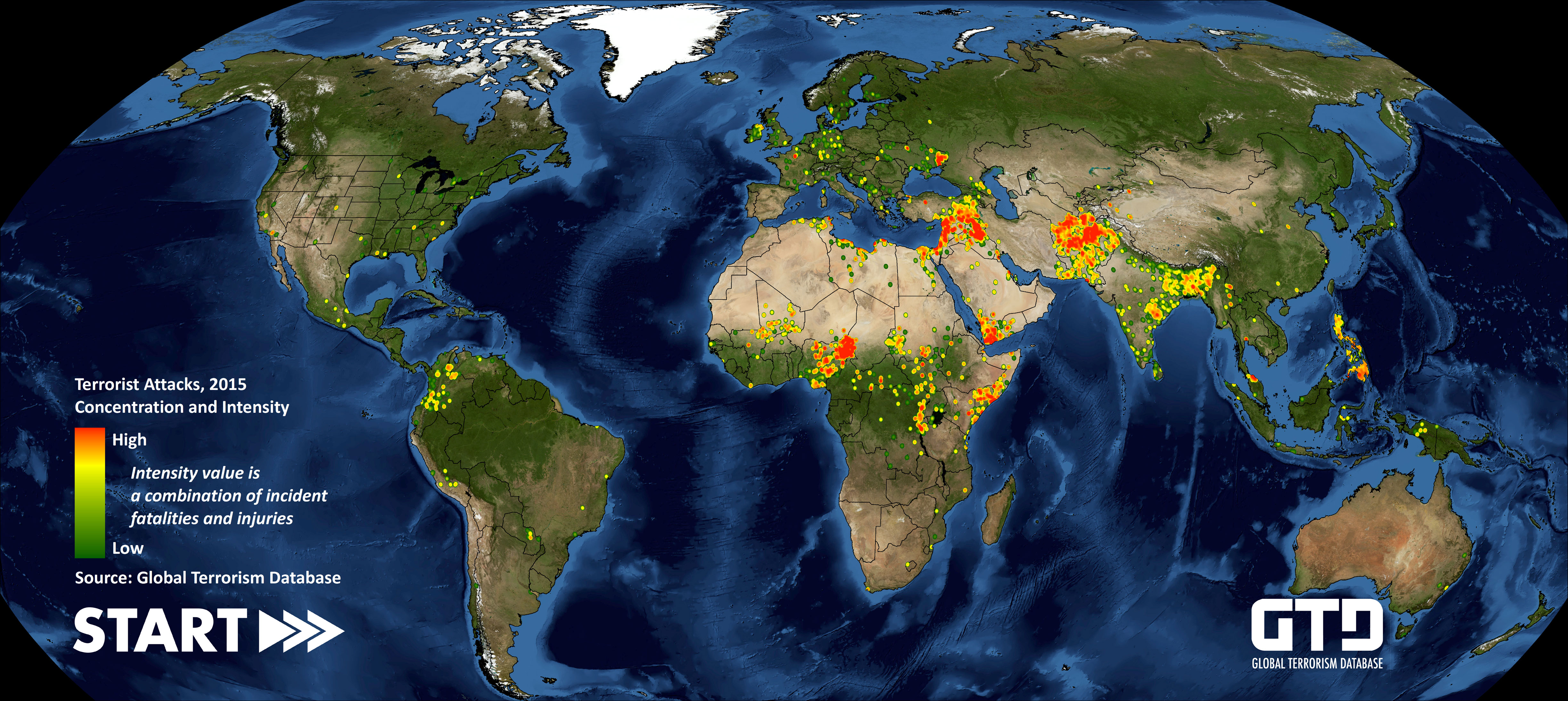
Annex M5 Terrorist Attacks, Concentration and Intensity Map, Global Terrorism
Database, 2015
Annex M6 Terrorist Threat Assessment, 2017. Kenya National Intelligence Service
4
EXHIBITS
KENYAN LEGISLATION
Annex 1 Proclamation of the President of the Republic of Kenya Concerning the
Convention on Territorial Sea and Contiguous Zone of the Republic of
Kenya, Kenya Gazette Supplement No. 44, Legislative Supplement No. 31,
Legal Notice No. 147, 13 June 1969
Annex 2 Confidential Memorandum from the Minister of Foreign Affairs to the
Cabinet, Territorial Waters Legislation, containing the 1970 Territorial
Waters Bill, 8 August 1970
Annex 3 Republic of Kenya, The Continental Shelf Act No. 3 of 1975, 25 March
1975
Annex 4 Republic of Kenya, The National Assembly, Official Report, Third
Parliament Inaugurated 6th November 1974, Vol. L, Wednesday 2nd May,
1979 to Friday 29th June, 1979 (Hansard), Friday, 4th May, 1979, Oral
Answers to Questions, No. 246, col.125–126
Annex 5 Republic of Kenya, the National Assembly Official Report, Fourth
Parliament Inaugurated, Vol. LII, 4th December 1979, First Session,
Tuesday, 4th December, 1979, Second Session, Tuesday, 4th December,
1979 to Wednesday, 18th June, 1980, Records of 22 May 1980, col. 1225–
1226 and 27 May 1980, col. 1281–1282
Annex 6 Republic of Kenya, the National Assembly Official Report, Fourth
Parliament Inaugurated, Vol LIX, 4 December 1979, 4th session, 28
September 1982 to 9 December 1982, Committee of Supply, Vote 4
Ministry for Foreign Affairs, 27 October 1982, col. 871–872
Annex 7 Republic of Kenya, Gazette Notice no. 9800 of 1 December 2006, The
Petroleum (Exploration and Production) Act, Cap. 308, pp. 2861–75
5
SOMALI LEGISLATION
Annex 8 The Constitution of the Somali Republic, 1 July 1960, as amended up to 31
December 1963, Article 6
Annex 9 Guidelines for Fisheries Joint Venture with Foreign Partners, Somali
Democratic Republic, Ministry of Fisheries & Marine Resources, 1 April
1985
Annex 10 Federal Republic of Somalia, Ministry of Fisheries and Marine Resources,
Somali Fishery Law No. 23, 30 November 1985
KENYAN GOVERNMENT DOCUMENTS
Annex 11 Report from the Kenya Permanent Mission to the United Nations on the
Work of the Second Session of the Third United Nations Conference on the
Law of the Sea, held in Caracas, Venezuela, from 20th June to 29th August
1974 (273/430/001A/15), received by the Kenyan Ministry of Foreign
Affairs on 28 October 1974, Extract
Annex 12 MFA Internal Memo from A.S. Legal to Dr Adede on the Consultative
Interministerial Meeting of the Law of the Sea Group held at Harambee
House on 12 August 1975 (MFA. 273/430/001A/66), 26 August 1975
Annex 13 Letter from the Permanent Mission of Kenya to the United Nations (Frank
X. Njenga) to the Permanent Secretary of the Ministry of Foreign Affairs
(att: Dr Adede) (KMUN/LAW/MSC/23A/16), Law of the Sea: Kenya’s
National Jurisdiction, 19 September 1975
Annex 14 Letter from the Permanent Mission of Kenya to the United Nations to the
United Nations Secretary-General (KMUN/LAW/MSC/23A/7) forwarded to
the Ministry of Affairs, Agreement on the Territorial Sea Boundary between
Kenya and Tanzania, 18 April 1977
Annex 15 Report from the Kenyan Embassy in Somalia to the Ministry of Foreign
Affairs, Mission Mogadiscio (KES.105A.Vol.II/73), The Ambassador’s
Meetings with Somali Ministers, 4 April 1978
Annex 16 Letter from the Canadian High Commission in Nairobi (MFA 273/430/XII),
Note for Mr. Njenga, Kenya — Territorial Sea and Economic Zone, undated
Annex 17 Letter from Frank X. Njenga, Permanent Secretary, to the Director of the
Survey of Kenya (MFA. 273/430/001A/89), Kenya Territorial Sea and
6
Economic Zone, 11October 1978
Annex 18 Letter from the Kenyan Ministry of Foreign Affairs to the Kenya Permanent
Mission to the United Nations (MFA.273/430/001A/81), Proclamation by
the President of the Republic of Kenya on Kenya’s Exclusive Economic
Zone, 5 March 1979
Annex 19 Letter from the Permanent Mission of Kenya to the United Nations to the
United Nations Secretary-General (KMUN/LAW/MSC/23A/49), 9 March
1979
Cover letter from the Permanent Mission of Kenya to the United Nations to
the Ministry of Foreign Affairs (KMUN/LAW/MSC/23A/50), Proclamation
of the President of the Republic of Kenya on Kenya's Exclusive Economic
Zone, 9 March 1979
Annex 20 Letter from the United Nations Secretary-General (LE 113 (3-3)), 19 July
1979, forwarded by the Permanent Mission of Kenya to the United Nations
to the Ministry of Foreign Affairs (KMUN/LAW/MSC/23/18),
Proclamation of Kenya’s Exclusive Economic Zone, 25 October 1979
Annex 21 Letter from F.X. Njenga to the Director of Surveys of the Survey of Kenya
(MFA. 273/430/001A/49), Kenya Territorial Sea/Economic Zone, 26
October 1979
Annex 22 Letter from the Kenyan Embassy in China to the Ministry of Foreign Affairs
(KEP/POL/GEN/1A/59), Vice-Minister Ho Ying’s Tour, 30 January 1980
Annex 23 Second Report of the Ninth Session of 3rd UNCLOS (New York from 3
March to 4 April 1980) from the Kenya Permanent Mission to the United
Nations to the Ministry of Foreign Affairs, Delimitation of Maritme [sic]
Boundaries, 14 March 1980
Annex 24 Letter from the Permanent Secretary to the Vice President, Minister for
Finance and the Office of the President (MFA.231/21/001A/92), 6 May
1980, enclosing the minutes of a meeting held at the Inter-continental Hotel
Nairobi on 20th April 1980 between H.E. Kenya’s Vice President Mr. Mwai
Kibaki and H.E. the Somali Vice President Mr. Hussein Kulmie Afrah
Annex 25 Telegram to the Ministry of Foreign Affairs, No. 227
(MFA/231/21/001A/245), Account of Siad Barre’s Address at Mass Rally, 2
December 1980
Annex 26 Minutes of a Meeting between H.E. President Daniel T. Arap Moi and H.E.
President Siad Barre on June 29, 1981, at State House, Nairobi
(MFA/231/21/001A/28), 10 July 1981
7
Annex 27 Note on a Meeting between Hon. Ole Tipis, Minister of State in the Office
of the President and the Somalia Ambassador to Kenya, H.E. MR.
Abdirahman Hussein Mahamoud (MFA/231/21/001A/68), 7 September
1982
Annex 28 Letter from Fisheries Officer (IDA) D. Opere Jr. to the Ag. Assistant
Director of Fisheries (FISH/MSA/118/VOL. III/48), Report on the Survey
Carried out in the Kenyan Waters by R/V “DR. FRIDTJOF NANSEN”, 14
September 1982
Annex 29 Letter from the Office of the President to the Permanent Secretary of the
Ministry of Foreign Affairs (OP.31/5A/VIII/70), Clearing Kenya-Somalia
Border, 12 October 1982, enclosing the minutes of meetings of the Kenya
Intelligence Committee held on 28 September 1982, Relations between
Kenya and Somalia (Min. 254/82) and Clearing of Kenya/Somalia Border
(Min. 268/82)
Annex 30 Letter from the Kenyan Embassy in Somalia to the Ministry of Foreign
Affairs (KES.l52A/VOL.X/233), Ngugi Wa Thiongo, 7 April 1985
Annex 31 Confidential telegram (Conf. C4. Fishing Trawler.) from Kenya Navy
Headquarters to KNS JAMHURI, 21 April 1989
Annex 32 Report of Proceeding of KNS JAMHURI on a North and South Coast Patrol
from 20 February to 25 February 1990, Kenya Navy, Report dated 28
February 1990
Annex 33 Report of Proceedings of KNS JAMHURI on a North Coast Patrol from 4
September to 10 September 1990 (KNS/32/Ops/Trg), Kenya Navy, Report
dated 16 September 1990
Annex 34 Report of Proceedings of KNS NYAYO while on a North Coast Patrol from
12th Sept 90 to 18 Sept 90, KNS NYAYO at Mkunguni, Kenya Navy, 29
September 1990
Annex 35 Report of Proceedings of KNS UMOJA while on a North/South Patrol from
19 September 1990 to 25 September 1990, Kenya Navy, Report dated 12
October 1990
Annex 36 Report of Proceeding of KNS HARAMBEE on North Coast
Patrol/Operation Exodus from 20 Sep to 27 Sep 1991, Kenya Navy, Report
dated 3 October 1991
Annex 37 Report of Proceeding of KNS MAMBA on a North and South Coast Patrol
from 26 Sep to 3 Oct 91, Kenya Navy, Report dated 17 October 1991
8
Annex 38 Hydrocarbon Potential of the Coastal Onshore and Offshore Lamu Basin of
South-East Kenya: Integrated Report, National Oil Corporation of Kenya,
1995, Extracts
Annex 39 Production Sharing Contract between the Government of the Republic of
Kenya and Star Petroleum International (Kenya) Limited for Block L-5
Lamu Basin, 11 July 2000
Annex 40 Technical Report on Kenya-Somalia Boundary, Re-establishment of
Boundary Pillar BP29 at Dar Es Salam Border Point, prepared by Julius K.
Rotich, Surveyor/Team Leader, Survey of Kenya, August 2003
Annex 41
Republic of Kenya, Fishing Licence for French vessel “Franche Terre”,
0000455, r.6/LN.35/91, 1 July 2011-30 June 2012, granted on 20 June 2011
Annex 42
Production Sharing Contract between the Government of the Republic of
Kenya and Eni Exploration and Production Holding B.V. relating to Block
L21, 29 June 2012, Extracts
Annex 43 Operations Linda Nchi, Kenya’s Military Experience in Somalia, Ministry of
Defence — Kenya Defence Forces, Kenya Literature Bureau, Nairobi,
Kenya, 2014, pp. 20–23
Annex 44 Brief by Lt Col J.S. Kiswaa for Commander Kenya Navy, Information on
Extent of Military Vessel Patrols in the Indian Ocean (KN/56/Ops/Trg),
Kenya Navy, July 2015, including:
Annex A to KNS/32/OPS/TRG, Ships Log Extracts From Kenya Navy Ships
Patrols Within The Common Border, June 2015
Annex C to KN/56/OPS/TRG, Interception of Merchant Vessels by Kenya
Navy Ships while on Patrol in the Common Border FM 1990–2014, 23 July
2015
Annex 45 Letter from the Ministry of Energy & Petroleum, State Department for
Petroleum to the Office of the Attorney-General & Department of Justice,
Professor Muigai (ME/CONF/3/2/1), Maritime Delimitation in the Indian
Ocean (Somalia vs Kenya): Activities in the Disputed Area, 5 May 2016
Annex 46 Defence White Paper, Republic of Kenya, Ministry of Defence, May 2017,
Extract
Annex 47 Letter from Lt-Col Atodonyang to Ms Juster Nkoroi, Kenya Navy, Evidence
Gathering in Respect of Maritime Border Dispute between Kenya and
Somalia, 1 September 2017
9
Annex 48 Letter from Lt-Col Atodonyang to Ms Juster Nkoroi, Kenya Navy, Evidence
Gathering in Respect of Maritime Border Dispute between Kenya and
Somalia, 5 October 2017
Annex 49 Witness Statement of the Cabinet Secretary, Ministry of Foreign Affairs,
Republic of Kenya, Amb. (Dr.) Amina C. Mohamed, EGH, CAV, 18
October 2017
SOMALI GOVERNMENT DOCUMENTS
Annex 50 Yearly Fisheris [sic] and Marine Transport Report 1987/1988, Somali
Democratic Republic, Ministry of Fisheries and Marine Transport
Annex 51 Preparing for Hydrocarbon Exploration Somalia, Federal Ministry of
Petroleum and Mineral Resources, Federal Republic of Somalia, 2016
THIRD-PARTY GOVERNMENT DOCUMENTS
Annex 52
United States Department of State, Office of the Geographer, Bureau of
Intelligence and Research, Limits in the Sea, Kenya — Tanzania Maritime
Boundary, Report No. 92, 23 June 1981
Annex 53 United States Department of State, Bureau of Intelligence and Research,
Limits in the Seas, Straight Baselines: Vietnam, Report No. 99, 12 December
1983
Annex 54 The Proceedings of the NORAD-Kenya Seminar to Review the Marine Fish
Stocks and Fisheries in Kenya, Mombasa, Kenya, 13–15 March 1984, Kenya
Marine and Fisheries Research Institute, Mombasa, Norwegian Agency for
International Development, Institute of Marine Research, Bergen, Norway,
1984, Extract
Annex 55 Somalia: An Evaluation of the Coastal Development Agency’s Fisheries
Program, Report for USAID Mogadishu by International Science and
Technology Institute Washington, July 1985, Appendix 9, Extract
Annex 56 U.S. Trade and Investment with Sub-Saharan Africa, United States
International Trade Commission, Third Annual Report, Investigation No.
332-415, USITC Publication 3552, December 2002, pp. 247–8
10
Annex 57 Country Information & Policy Unit, Somalia, Immigration and Nationality
Directorate Home Office, United Kingdom, April 2004, Extract
DIPLOMATIC CORRESPONDENCE
Annex 58 Note Verbale from the Kenyan Ministry of Foreign Affairs to the Somali
Ministry of Foreign Affairs, (MFA.TCA 12/34 VOL.XI (110)), 13 August
2014 forwarded to the Somali Embassy in Nairobi to be transmitted to the
Somali Ministry of Foreign Affairs (MFA.TCA 12/34 Vol. XI (109)), 13
August 2014
Annex 59 Letters from the Kenyan Office of the Attorney-General and Department of
Justice to the Somali Minister of Foreign Affairs (AG/CONF/19/153/2 VOL.
III), 22 February 2016 and 29 April 2016
Annex 60 Letter from the Somali Ministry of Foreign Affairs to the Registrar of the
International Court of Justice, 13 May 2016
Annex 61 Letter from the Kenyan Ministry of Foreign Affairs to the Somali Ministry of
Foreign Affairs, 18 May 2016, sent to the Somali Embassy in Nairobi by note
verbale (MFA.INT.8/15A) dated 25 May 2016
Annex 62 Letter from the Kenyan Office of the Attorney-General and Department of
Justice to the Registrar of the International Court of Justice
(AG/CONF/19/153/2 VOL. III), 27 May 2016
Annex 63 Letter from the Kenyan Office of the Attorney-General and Department of
Justice to the Embassy of Norway in the Netherlands (AG/CONF/19/153/2
VOL. III), 8 June 2016
Annex 64 Letter from the Somali Ministry of Foreign Affairs to the Kenyan Ministry of
Foreign Affairs (MFA/SFR/OM2378/2016), 18 June 2016
Annex 65 Letter from the Office of Legal Affairs of the United Nations to the Permanent
Mission of the Republic of Kenya to the United Nations, received 8 November
2017
11
DOCUMENTS PUBLISHED BY
INTERNATIONAL ORGANISATIONS
Annex 66 Asian-African Legal Consultative Committee, Report of the Thirteenth
Session Held in Lagos, Working Paper on “The Exclusive Zone Concept”
prepared by the Government of Kenya as member of the working group on the
law of the sea, January 1972, pp. 155–60
Annex 67 Draft articles on exclusive economic zone concept, submitted by Kenya, U.N.
Doc. A/AC.138/SC.II/L.10, Report of the Committee on the Peaceful Uses of
the Sea-Bed and the Ocean Floor Beyond the Limits of National Jurisdiction,
GAOR, Twenty-Seventh Session, Supp. No.21 (A/8721), 1972, pp.180–2
Annex 68 Kenya and other African States, Draft Articles on Exclusive Economic Zone,
U.N. Doc. A/AC.138/SC.II/L.40, reproduced in Official Records, United
Nations General Assembly: Twenty-Eighth Session, Supp. 21 (A/9021), 1973,
Vol. 3, p. 87–9
Annex 69 Third UNCLOS, Informal Suggestions NG7/4, NG7/10, NG7/10/Rev.1 and
NG7/10/Rev.2, 1978–1980, Third United Nations Conference on the Law of
the Sea: Documents by Renate Platzöder, Oceana Publications, 1986, Vol. IX
Annex 70 Report by the Chairman of the Negotiating Group 7 on the work of the Group
at its 17th-27th meetings, NG7/24, 14 September 1978, U.N. Doc.
A/CONF.62/RCNG/2, UNCLOS III Official Records, Vol. X, pp. 170–2
Annex 71 128th Plenary meeting, 3 April 1980, A/CONF.62/SR.128, Official Records of
the Third United Nations Conference on the Law of the Sea, Volume XIII,
Ninth Session, p.35 and p.44
Annex 72 138th Plenary meeting, 26 August 1980, A/CONF.62/SR.138, Official Records
of the Third United Nations Conference on the Law of the Sea, Volume XIV,
Resumed Ninth Session, pp. 55–6
Annex 73 192nd Plenary meeting, 9 December 1982, A/CONF.62/SR.192, Official
Records of the Third United Nations Conference on the Law of the Sea,
Volume XVII, Resumed Eleventh Session and Final Part Eleventh Session and
Conclusion, p. 127
Annex 74 The Stock Assessment of the Kenyan Demersal Offshore Resources, Surveyed
in the Period 1979–1980–1981, Project KEN/74/023 “Offshore Trawling
Survey”, Work Report No. 8, UNDP/FAO, Government of Kenya, Ministry of
Environment and Natural Resources, January 1982, Extract
Annex 75 Statement from the Ministry of Foreign Affairs of the People’s Republic of
12
China, Law of the Sea Bulletin No. 1, Division for Ocean Affairs and the Law
of the Sea, Office of Legal Affairs, September 1983, p.76
Annex 76 Offshore Trawling Survey Kenya, Project Findings and Recommendations,
FI:DP/KEN/74/023 Terminal Report, FAO/UNDP, Rome 1983, Extract
Annex 77 United Nations General Assembly draft resolutions sponsored by Somalia,
1991
Annex 78 United Nations General Assembly draft resolutions sponsored by Somalia,
1992
Annex 79 United Nations Economic and Social Council draft resolutions sponsored by
Somalia, 1993–1995
Annex 80
Somalia’s consistent assertion of a 200-nautical mile territorial sea before the
United Nations, Law of the Sea Bulletins, Division for Ocean Affairs and the
Law of the Sea, Office of Legal Affairs, 1993–2010
Annex 81 M. Odido, Marine Science Country Profiles: Kenya, IOCINCWIO-IV/Inf.5,
UNESCO, IOC and Western Indian Ocean Marine Science Association, 1998,
Extracts
Annex 82 G. Saetersdal et al, The Dr. Fridtjof Nansen Programme 1975–1993.
Investigations of Fishery Resources in Developing Regions. History of the
Programme and Review of Results. FAO Fisheries Technical Paper. No. 391,
Rome, FAO. 1999, Extracts
Annex 83 U.N. Doc A/55/PV.16, United Nations General Assembly, Official Records,
Fifty-fifth session, 16th plenary meeting, 15 September 2000, Address by Mr.
Salim Abdikassim Salad Hassan, President of the Somali Republic
Annex 84 United Nations Security Council, Report of the Secretary-General on the
situation in Somalia, S/2000/1211, 19 December 2000
Annex 85 Letter dated 21 March 2001 from the Prime Minister of Somalia addressed to
the President of the Security Council, S/2001/263, 23 March 2001
Annex 86 Executive Board of the United Nations Development Programme and of the
United Nations Population Fund, Assistance to Somalia (2002–2004), Note by
the Administrator, DP/2002/29, 8 August 2002
Annex 87 United Nations Security Council, Report of the Secretary-General on the
13
situation in Somalia, S/2004/115, 12 February 2004, Extract
Annex 88 United Nations Security Council, Report of the Secretary-General on the
situation in Somalia, S/2004/469, 9 June 2004
Annex 89 Information note by Turkey, concerning its objection to the Agreement
between the Republic of Cyprus and the Arab Republic of Egypt on the
Delimitation of the Exclusive Economic Zone, 17 February 2003, Law of the
Sea Bulletin No. 54, Division for Ocean Affairs and the Law of the Sea, Office
of Legal Affairs, 2004, p. 127
Annex 90 Yearbook of the United Nations, 2004, Volume 58, Department of Public
Information, United Nations, New York, pp.256–7
Annex 91 United Nations Security Council, Report of the Secretary-General on the
situation in Somalia, S/2005/642, 11 October 2005
Annex 92
Kenya’s 2005 EEZ Proclamation with Coordinates, Law of the Sea Bulletin
No. 61, Division for Ocean Affairs and the Law of the Sea, Office of Legal
Affairs, 2006, pp. 96–7
Annex 93 FAO Fishery Country Profile: The Republic of Kenya, FID/CP/KEN, April
2007, Extract
Annex 94
Coastal Livelihoods in the Republic of Somalia, Agulhas and Somali Current
Large Marine Ecosystems (ASCLME) Project, 2010, Extracts
Annex 95 Security Council Resolution 1976 (2011), S/RES/1976 (2011), 11 April 2011
Annex 96
DOALOS Table of National Claims to Maritime Jurisdiction, as at 15 July
2011, p.16
Annex 97 Security Council Resolution 2067 (2012), S/RES/2067 (2012), 18 September
2012
Annex 98 Security Council Resolution 2077 (2012), S/RES/2077 (2012), 21 November
2012
Annex 99 Report of the Monitoring Group on Somalia and Eritrea pursuant to Security
Council resolution 2111 (2013), S/2014/726, 13 October 2014, Annex 5.1:
Illustrative overview of contracts, pp. 192–7
Annex 100
Kenya DOALOS Page, updated 14 October 2014
14
Annex 101 Letter from the Coordinator of the Somalia and Eritrea Monitoring Group
mandated pursuant to paragraph 46 of Security Council resolution 2182
(2014) to the Chair of the Security Council Committee pursuant to resolutions
751 (1992) and 1907 (2009) concerning Somalia and Eritrea, reporting the
initial findings of the Monitoring Group’s investigation into the operations of
Soma Oil & Gas Holdings Limited (Soma), S/AC.29/2015/SEMG/OC.31, 28
July 2015
Annex 102 Somalia DOALOS Page, updated 10 April 2017
NEWSPAPERS & INDUSTRY REPORTS
Annex 103 East African Standard extracts, 21, 23 and 24 September, 5 and 6 October 1970
Annex 104 P. Giorgio Scorcelletti and B. M. Abbott, Petroleum Developments in Central
and Southern Africa in 1978, The American Association of Petroleum
Geologists Bulletin V. 63, No. 10, pp. 1689-1742, October 1979, at p. 1694
Annex 105 P. B. Gupte, Somalia Calls for Talks with Ethiopia, New York Times, 30 June
1981
Annex 106 Demonstrators Protest Exploration Deal in Somalia, World Oil, March 2001
Annex 107 T. Griffiths, Woodside’s Kenya Deal Raises Hopes: Is East Africa the Next Big
Thing?, African Energy, June 2003, pp. 4–6
Annex 108 Woodside Concise Annual Report, 2005, p.16
Annex 109 Woodside Spuds Offshore Well; Kenya’s Oil Future to be Determined in 2007,
IHS Same-Day Analysis, 12 May 2006
Annex 110 Woodside Controlled Document, Pomboo-A Well Proposal, Block L-5
Deepwater, Kenya East Africa, June 2006, Extracts
Annex 111 Kenya Offshore Exploration Drilling Blocks L-5 and L-7, Environmental Audit
Report, Woodside, March 2007
Annex 112 Unlocking Somalia’s Potential, Eastern African Oil, Gas — LNG Energy
Conference, Soma Oil & Gas Presentation, Nairobi, Kenya, 29–30 April 2014
Annex 113 Exit Strategy Challenges for the AU Mission in Somalia, The Heritage Institute
for Policy Studies, February 2016, Extract
15
Annex 114 Unlocking Somalia’s Potential, Soma Oil & Gas, Company Presentation, Q2
2016, Slide 4
ACADEMIC AUTHORITIES
Annex 115 J.T. Juxon Barton, “Report on the Bajun Islands” (1922) 17 Journal of the East
Africa and Uganda Natural History Society p. 24
Annex 116 D. Anzilotti, Cours de droit international (Sirey 1929) p. 347
Annex 117 E. Brüel, “La protestation en droit international” (1932) 3 Nordisk tidsskrift for
international ret (Nordic Journal of International Law) pp. 84–5
Annex 118 C. de Visscher, Problèmes d’interprétation judiciaire en droit international
public (Pedone 1963) pp. 183–4
Annex 119 R. Jennings, The Acquisition of Territory in International Law (Manchester
University Press 1963) p. 45
Annex 120 Speech by H.E. Judge Gilbert Guillaume, President of the International Court
of Justice, to the Sixth Committee of the General Assembly of the United
Nations, 31 October 2001
Annex 121 R. Kolb, Case Law on Equitable Maritime Delimitation: Digest and
Commentaries (Martinus Nijhoff 2003) p. 13
Annex 122 C. Mugnier, “Republic of Kenya” (June 2003) Photogrammetric Engineering
and Remote Sensing pp. 593–7
Annex 123 P. Nugent, Africa Since Independence: A Comparative History, (2nd edn.,
Palgrave Macmillan 2012) p. 105
Annex 124 T. Cottier, Equitable Principles of Maritime Boundary Delimitation (CUP
2015) pp. 242–52
Annex 125 R. Kolb, Good Faith in International Law (Hart 2017) pp. 92–5.
16
Annex 126 M. Kamto, “Considérations actuelles sur la méthode de délimitation maritime
devant la Cour internationale de Justice. De charybde en scylla ?” in Mélanges
Momtaz (Brill Nijhoff 2017), pp. 411–16 and 419–20.
ARBITRAL AWARDS NOT READILY
AVAILABLE
Annex 127 Costa Rican–Nicaraguan Boundary (“Cleveland Award”) (1888) 2 J.B. Moore,
History and Digest of the Arbitrations to which the US has been a Party 1945,
p. 1961.
INTERNATIONAL AGREEMENTS
Annex 128 Declaration on the maritime zone (Chile, Ecuador and Peru), 18 August
1952, 1006 UNTS 325
Annex 129 Agreement relating to a Special Maritime Frontier Zone (Chile, Ecuador
and Peru), 4 December 1954, 2274 UNTS 527
Annex 130 Agreement between Norway and the Soviet Union Concerning the Sea
Frontier in the Varangerfjord, 15 February 1957, JI Charney & LM
Alexander (eds), International Maritime Boundaries II (Nijhoff 1993) p.
1786
Annex 131 Exchange of Notes between France and Portugal Regarding the Maritime
Boundary between Senegal and Portuguese Guinea, 26 April 1960, JI
Charney & LM Alexander (eds), International Maritime Boundaries I
(Nijhoff 1993) p. 873
Annex 132
Agreement between The Gambia and the Republic of Senegal, 4 June
1975, JI Charney & LM Alexander (eds), International Maritime
Boundaries I (Nijhoff 1993) p. 854
Annex 133 Agreement concerning delimitation of marine and submarine areas and
maritime co-operation (Colombia and Ecuador), 23 August 1975, 996
UNTS 239
17
Annex 134 Convention concerning the State frontier line established between the
Islamic Republic of Mauritania and the Kingdom of Morocco (with
map), 14 April 1976, 1035 UNTS 120.
Annex 135 Post-1992 maritime delimitations between States with adjacent coasts
(other than those enumerated in the text of the Counter-Memorial).
The annex includes these delimitations:
International Boundary Agreement between the Sultanate of Oman and
the Republic of Yemen, 1 October 1992, 1709 UNTS 409
Treaty on the State Border Between the Republic of Croatia and Bosnia
and Herzegovina, 30 July 1999, JI Charney & RW Smith (eds),
International Maritime Boundaries IV (Brill Nijhoff 2002) p. 2891
Maritime Boundary Agreement between the Government of the State of
Israel and the Government of the Hashemite Kingdom of Jordan, 18
January 1996, JI Charney & LM Alexander (eds), International Maritime
Boundaries III (Brill Nijhoff 1998) p. 2460
Agreement between the government of the Republic of Estonia, the
government of the Republic of Latvia and the government of the
kingdom of Sweden on the common maritime boundary point in the
Baltic Sea, 30 April 1997, JI Charney & RW Smith (eds), International
Maritime Boundaries IV (Brill Nijhoff 2002) p. 3056
Agreement between the Kingdom of Belgium and the Kingdom of the
Netherlands relating to the Delimitation of the Territorial Sea and
Agreement between the Kingdom of Belgium and the Kingdom of the
Netherlands relating to the Delimitation of the Continental Shelf, 18
December 1996, JI Charney & RW Smith (eds), International Maritime
Boundaries IV (Brill Nijhoff 2002) p. 2936
Protocol Between the Government of the Republic of Turkey and the
Government of Georgia on the Confirmation of the Maritime Boundaries
Between Them in The Black Sea, 14 July 1997, JI Charney & RW Smith
(eds), International Maritime Boundaries IV (Brill Nijhoff 2002) p. 2867
Treaty between the Republic of Lithuania and the Russian Federation on
the Delimitation of the Exclusive Economic Zone and the Continental
Shelf in the Baltic Sea, 24 October 1997, JI Charney & RW Smith (eds),
International Maritime Boundaries IV (Brill Nijhoff 2002) p. 3073
Agreement Between the Republic of Turkey and the Republic of Bulgaria
on the Determination of the Boundary in the Mouth Area of the
18
Mutludere/Rezovska River and Delimitation of the Maritime Areas
Between the Two States in the Black Sea, 4 December 1997, JI Charney
& RW Smith (eds), International Maritime Boundaries IV (Brill Nijhoff
2002) p. 2879
Agreement between the Republic of Kazakhstan and the Russian
Federation on Demarcation of the Seabed in the Northern Caspian Sea
for the Purpose of Exercising Sovereign Rights to the Use of the Subsoil
Resources, 6 July 1998, DA Colson & RW Smith (eds), International
Maritime Boundaries V (Brill Nijhoff 2005) p. 4022
Treaty on the State Border between the Republic of Croatia and Bosnia
and Herzegovina, 30 July 1999, JI Charney & RW Smith (eds),
International Maritime Boundaries IV (Brill Nijhoff 2002) p. 2891
Agreement between the Republic of Lithuania and the Republic of Latvia
on the delimitation of the territorial sea, exclusive economic zone and
continental shelf in the Baltic Sea, 9 July 1999, JI Charney & RW Smith
(eds), International Maritime Boundaries IV (Brill Nijhoff 2002) p. 3125
The Final and Permanent Border Treaty between the Kingdom of Saudi
Arabia and the Republic of Yemen, 12 June 2000, JI Charney & RW
Smith (eds), International Maritime Boundaries IV (Brill Nijhoff 2002)
p. 2807
Treaty between the Government of the United States of America and the
Government of the United Mexican States on the Delimitation of the
Continental Shelf in the Western Gulf of Mexico beyond 200 Nautical
Miles, 9 June 2000, JI Charney & RW Smith (eds), International
Maritime Boundaries IV (Brill Nijhoff 2002) p. 2629
Agreement between the Kingdom of Saudi Arabia and the State of
Kuwait Concerning the Submerged Area Adjacent to the Divided Zone,
JI Charney & RW Smith (eds), International Maritime Boundaries IV
(Brill Nijhoff 2002) p. 2837
Agreement between the Republic of Kazakhstan and the Azerbaijani
Republic on Delimitation of the Caspian Seabed between the Republic of
Kazakhstan and the Azerbaijani Republic, 29 November 2001, DA
Colson & RW Smith (eds), International Maritime Boundaries V (Brill
Nijhoff 2005) p. 4048
Agreement between the Republic of Azerbaijan and the Russian
Federation on Delimitation of Adjacent Areas of the Caspian Seabed, 23
September 2002, DA Colson & RW Smith (eds), International Maritime
Boundaries V (Brill Nijhoff 2005) p. 4039
19
Agreement between the Republic of Azerbaijan, the Republic of
Kazakhstan, and the Russian Federation Concerning the Trijunction Point
of the Lines of Delimitation of Adjacent Sectors of the Caspian Seabed,
14 May 2003, DA Colson & RW Smith (eds), International Maritime
Boundaries V (Brill Nijhoff 2005) p. 4056
Agreement to Mark the Maritime Borders between The Republic of
Yemen and The Sultanate of Oman, 14 December 2003, DA Colson &
RW Smith (eds), International Maritime Boundaries V (Brill Nijhoff
2005) p. 3909
Treaty between the Republic of Estonia and the Russian Federation on
the Delimitation of the Maritime Areas in the Gulf of Narva and the Gulf
of Finland, 18 May 2005, DA Colson & RW Smith (eds), International
Maritime Boundaries VI (Brill Nijhoff 2011) p. 4582
Treaty on the Maritime Boundary Delimitation between The Federal
Republic of Nigeria and The Republic of Benin, 4 August 2006, DA
Colson & RW Smith (eds), International Maritime Boundaries VI (Brill
Nijhoff 2011) p. 4266
Agreement between the Russian Federation and the Kingdom of Norway
on the Maritime Delimitation in the Varangerfjord area, 11 July 2007,
DA Colson & RW Smith (eds), International Maritime Boundaries VI
(Brill Nijhoff 2011) p. 4485
Agreement on the Delimitation of the Maritime Boundaries on the Gulf
of Aqaba between the Kingdom of Saudi Arabia and the Hashemite
Kingdom of Jordan, 16 December 2007, C Lathrop (ed), International
Maritime Boundaries VII (Brill Nijhoff 2016) p. 5110
Agreement between the Republic of Albania and the Hellenic Republic
on the Delimitation of their Respective Continental Shelf Areas and other
Maritime Zones to which they are Entitled Under International Law, 29
April 2009, DA Colson & RW Smith (eds), International Maritime
Boundaries VI (Brill Nijhoff 2011) p. 4470
Agreement by Exchange of Notes of Identical Content between the
Republic of Peru and the Republic of Ecuador, 2 May 2011, C Lathrop
(ed), International Maritime Boundaries VII (Brill Nijhoff 2016) p. 4776
Agreement between the Government of the French Republic and the
Government of the Italian Republic regarding the Delimitation of the
Territorial Seas and Zones under National Jurisdiction between France
and Italy, 21 March 2015, International Maritime Boundaries (2016
20
annual online update) p. 11.
Annex 136 Exchange of Notes between the United Republic of Tanzania and Kenya
Concerning the Delimitation of the Territorial Waters Boundary between
the Two States, 9 July 1976, JI Charney and LM Alexander (eds),
International Maritime Boundaries I (Nijhoff 1993)
Annex 137 Treaty on the delimitation of marine and submarine areas and related
matters (with maps) (Colombia and Panama), 20 November 1976, 1074
UNTS 221
Annex 138 Treaty on Delimitation of Marine and Submarine Areas and Maritime
Cooperation between the Republic of Colombia and the Republic of
Costa Rica, 17 March 1977, JI Charney and LM Alexander (eds),
International Maritime Boundaries Vol I (Nijhoff 1993) p. 474
Annex 139 Delimitation Treaty (with map) (France and Venezuela), 17 July 1980,
1319 UNTS 215
Annex 140 Convention on Maritime Delimitation between the Government of the
French Republic and the Government of His Serene Highness the Prince
of Monaco, 16 February 1984, 1411 UNTS 289
Annex 141 Treaty of Peace and Friendship (with annexes and maps) (Chile and
Argentina), 29 November 1984, 1399 UNTS 102
Annex 142 Agreement between the Government of the United Kingdom of Great
Britain and Northern Ireland and the Government of the Republic of
Ireland concerning the delimitation of areas of the continental shelf
between the two countries, 7 November 1988, (1989) 13 Law of the Sea
Bulletin 48
Annex 143 Agreement between the Government of the United Republic of Tanzania
and the Government of the People’s Republic of Mozambique Regarding
the Tanzania/Mozambique Boundary, 28 December 1988, JI Charney and
LM Alexander (eds), International Maritime Boundaries I (Nijhoff 1993)
p. 898
Annex 144 Treaty of the delimitation of marine and submarine areas (with maps)
(Venezuela and Trinidad and Tobago), 18 April 1990, 1654 UNTS 293
Annex 145 Agreement between the United States of America and the Union of
Soviet Socialist Republics on the maritime boundary, 1 June 1990,
(1991) 17 Law of the Sea Bulletin 15
21
Annex 146 Agreement between the People’s Republic of China and the Socialist
Republic of Viet Nam on the delimitation of the territorial seas, exclusive
economic zones and continental shelves of the two countries in Beibu
Gulf/Bac Bo Gulf (with maps), 25 December 2000, 2336 UNTS 179
Annex 147 Treaty between the Government of the Republic of Honduras and the
Government of the United Kingdom of Great Britain and Northern
Ireland concerning the Delimitation of the Maritime Areas between the
Cayman Islands and the Republic of Honduras, 4 December 2001, (2002)
49 Law of the Sea Bulletin 60
Annex 148 Treaty between the Government of the Republic of Angola and the
Government of the Republic of Namibia regarding the Delimitation and
Demarcation of the Maritime Borders between the Republic of Angola
and the Republic of Namibia, 4 June 2002, JI Charney & LM Alexander
(eds), International Maritime Boundaries V (Nijhoff 2005) p. 3719
Annex 149 Agreement on Technical and Economic Co-Operation between the
Government of the Republic of Kenya and the Transitional Federal
Government of the Republic of Somalia, 6 September 2005
Annex 150 Agreement on Natural Disasters Prevention, Management and
Humanitarian Relief Aid Delivery Cooperation between the Government
of the Republic of Kenya and the Transitional Federal Republic of
Somalia, 8 March 2006
Annex 151 Memorandum of Understanding between the Government of Kenya and
the Transitional Federal Government of the Republic of Somalia on
Training of Somali Policemen in Kenya, 3 May 2006
Annex 152 Joint minutes of on the land and maritime boundaries to the Agreement
of 4 December 1965 between the State of Qatar and the Kingdom of
Saudi Arabia on the delimitation of the offshore and land boundaries, 5
July 2008, (2009) 70 Law of the Sea Bulletin 45
Annex 153
Memorandum of Understanding between the Government of the
Republic of Kenya and the Transitional Federal Government of the
Republic of Somalia on Technical Assistance and Capacity Building, 18
March 2009
Annex 154
Treaty between the Kingdom of Norway and the Russian Federation
concerning Maritime Delimitation and Cooperation in the Barents Sea
and the Arctic Ocean, 15 September 2010, 2791 UNTS 3
Annex 155 Agreement on the Delimitation of the Maritime Boundary between the
Republic of Mozambique and the United Republic of Tanzania, 5
22
December 2011 (not yet in force), CG Lathorp (ed), International
Maritime Boundaries VII (Brill Nijhoff 2016) p. 4800
Annex 156 Joint Declaration by the Ministers of Foreign Relations of the Republics
of Ecuador and Colombia, 13 June 2012, CG Lathorp (ed), International
Maritime Boundaries VII (Brill Nijhoff 2016) p. 4765
Annex 157
Agreed Minutes on the Delimitation of the Continental Shelf beyond 200
Nautical Miles between Greenland and Iceland in the Irminger Sea, 16
January 2013, CG Lathorp (ed), International Maritime Boundaries VII
(Brill Nijhoff 2016) p. 5269
Annex 158
Tripartite Agreement between the Government of the Republic of Kenya,
the Government of the Federal Republic of Somalia and the United
Nations High Commissioner for Refugees governing the voluntary
repatriation of Somali refugees living in Kenya, 10 November 2013
Mogadishu
Kismaayo
Lamu
Mombasa
Tanga
Dar es Salaam
Pemba
Malindi
Socotra
Pemba
Zanzibar
Lamu
County
Wajir
Mandera
Garissa
Gedo
Middle
Juba
Lower
Juba
10°S
0°
10°N
40°E
0 200 400 M
0 200 400 600 800 km
WGS84/Mercator (0°)
50°E
KENYA
SOMALIA
TANZANIA
MOZAMBIQUE
SEYCHELLES
MADAGASCAR
COMOROS
YEMEN
FRANCE
MAURITIUS
Figure 1-1
The Regional Geographic Context
ETHIOPIA
Equidistance according
to Somalia
Perpendicular to general direction of the coast
3M limit
0 1 2 3 M
0 1 2 3 4 5 km
WGS84/Mercator (0°)
2005 Proclamation (ARC1960 →WGS84)
Parallel of latitude
1°40’S
41°35’E 41°40’E
SOMALIA
KENYA PB29
Ras Chiamboni
Dar es Salam
Diua Damasciaca
Islets
The 3 Nautical Mile Territorial Sea Boundary established by the 1933 Exchange of Notes compared to Somalia’s Equidistance Claim
Figure 1-2
Map of “Greater Somalia” including Kenya’s NFD Territory
Figure 1-3
Limits in the Seas No. 92 Maritime Boundary: Kenya-Tanzania, The Kenya-Tanzania Boundary Agreement 1975-6
U.S. Department of State, Office of the Geographer,
Bureau of Intelligence and Research, 23 June 1981 Figure 1-4
Equidistance
200M EEZ
0 10 20 30 40 50 M
0 20 40 60 80 100 km
WGS84 / Mercator (4°S)
40°E 42°E
6°S
4°S
KENYA
TANZANIA
KENYA
TANZANIA
Pemba Is
Zanzibar
Mombasa
Chake
Chake
Zanzibar
City
The Kenya-Tanzania Boundary compared to Equidistance
Figure 1-5
Kismaayo
Lamu
Mombasa
Malindi
Equidistance
2005 Proclamation
200M EEZ
Equidistance
0 50 100 M
0 50 100 150 200 km
WGS84/Mercator (0°)
SOMALIA
KENYA
TANZANIA
Figure 1-6
Delimitation of the EEZ contrasting the use of Equidistance and Parallels of Latitude
KENYA
TANZANIA
Kenya Territorial Sea and Economic Zone, Survey of Kenya, SK-90 Edition 1, 1976
Figure 1-7
Kenya Territorial Sea and Economic Zone, Survey of Kenya, SK-90 Edition 2, 1983
Figure 1-8
BP-29
LBT
INDIAN
OCEAN
S OMA L I A
K E N YA
S O M A L I A
Diua
Damasciaca
Islands
THE PARALLEL RESULTING FROM THE
COORDINATES SPECIFIED IN KENYA’S 2005
PRESIDENTIAL PROCLAMATION
(DigitalGlobe image taken on 9 February 2010 viewed in Google Earth)
Figure 5.2
The Parallel Boundary according to the coordinates
specified in the 2005 Presidential Proclamation
The point where the parallel line constructed on the basis
of the coordinates in the 2005 Presidental Proclamation
would hit the low-tide coast
Figure 5.2 from Somalia Memorial - overprinted in red
The Correct Location of the 2005 Presidential Proclamation
The 2005 Proclamation when referred
to the correct map datum (ARC1960)
Figure 1-9
2500
400
200
600
800
1600
1200
1000
1400
1800
3600
2000
2400
3200
3400
3000
2800
2600
2200
4000
3800
4200
4400
4800
4800
4600
KENYA'S EXCLUSIVE ECONOMIC ZONE
!
!
!
!
! .
.
.
.
.
! !
!
!
.
.
. .
&M
&M
&M
&M
&M
&M
&M
&M
&M
&M
&M&M
40°0'0"E
40°0'0"E
41°0'0"E
41°0'0"E
42°0'0"E
42°0'0"E
43°0'0"E
43°0'0"E
44°0'0"E
44°0'0"E
45°0'0"E
45°0'0"E
46°0'0"E
46°0'0"E
47°0'0"E
47°0'0"E
5°0'0"S 5°0'0"S
4°0'0"S 4°0'0"S
3°0'0"S 3°0'0"S
2°0'0"S 2°0'0"S
T a n a R i v e r
R i v e r G a l a n a
T a n a R i v e r
"
"
"
"
"
"
"
"
"
"
"
"
"
REPUBLIC OF SOMALIA
UNITED REPUBLIC
OF TANZANIA
REPUBLIC
OF KENYA
Pemba Island
B-MK
Chale Reef
Leven Reef
Ras Ngomeni
Leopard Reef
Mwamba Hasaani
Jumba La Mtwana
Mwamba wa Punju
Diua Damasciaca
Mwamba
Kitungamwe
Kiungamwina Drying Reef
T-A
T-B
T-C
T-D
E-C
E-B
E-A
T-DIUA DAMASCIACA E-DIUA DAMASCIACA
Hola
Witu
Lamu
Ijara
Kwale
Kilifi
Garsen
Mombasa
Kinango
Mambrui
Malindi
Kaloleni
Mariakani
BASELINE POINT............................................................................
BASELINES ( LIMIT OF INTERNAL WATERS)...........................
OUTER LIMIT OF CONTINENTAL SHELF .................................
MARITIME BOUNDARY ( BETWEEN STATES ).........................
INTERNATIONAL BOUNDARY.....................................................
KENYA-TANZANIA MEDIAN POINTS.........................................
1 Km FORMULA LINE (THE STATEMENT OF UNDERSTANDING)......
EXTENT OF EXCLUSIVE ECONOMIC ZONE.............................
ISOBATHS.........................................................................................
EXTENDED CONTINENTAL SHELF AREA.................................
ROADS..............................................................................................
TOWN................................................................................................
RIVER................................................................................................
200M.................................................................................................. 200 Nautical Miles
LEGEND
Mombasa
T a n a R i v e r
&M Chale Reef
!. T-A
2500
2600
!.
Datum : WGS 84
Digitally Compiled from :
East Africa 1 : 250,000 , Series Y 503 Sheets SA-37-15 KILIFI Edition
3-SK 1971, SB-37-3 MOMBASA Edition 4-SK 1982, KOLBIO-SA-37-8
HOLA-SA-37-7 GARSEN-SA-37-11, LAMU-SA-37, KILIFI SA-37-15,
SK74 South Sheet Edition 6 - SK, TANGA Series Y-503 Sheet SB-37-6 &
Part of SB-37-7 Edition 1 TSD, PEMBA ISLAND 1:250,000 Series Y601
Edition 3-GSGS 1965. Kenya Territorial Sea/Exclusive Economic Zone.
Baselines and Boundary lines plotted in accordance with the
United Nations Convention of the Law of the Sea (UNCLOS) 1982.
Baseline points from GPS Survey dated September 2004 .
The Outer Limit Points of the Extented Continental Shelf provided by the
Task Force on Delineation of Kenya's Outer Continental Shelf, 2009.
Prepared and printed by Survey of Kenya, April 2009.
C
NOTES
KENYA GOVERNMENT 2009
REPUBLIC OF KENYA
Nautical miles
Kilometres
10
10
20
20 30
30
40
40
50
50
60
60
70 80 90 100 110 120
70
130 140
80
150 160
Nautical miles 90 100
Kilometres 10
10 5
5
0
0
Scale 1 : 1,000,000
REPUBLIC OF KENYA'S OUTER LIMIT OF THE CONTINENTAL SHELF BEYOND 200M
SERIES SK 130 (a) EDITION 1 SK
E-B
2
EXTENDED
CONTINENTAL SHELF
AREA
Approx. 103, 320 Km
I N D I A N O C E A N
¬
20°W
0°
10°E
20°E
10°W
30°E
40°E
50°E
60°E
40°S
30°S
20°S
10°S
0°
10°N
20°N
30°N
40°N
CHART AREA
0 875 1,750 3,500 5,250 7,000 Kilometers
KEY MAP
The Outer Limit of the Extended Continental Shelf of Kenya
Figure 1-10
Map KEN-ES-DOC-MAP 1 from Kenya’s Executive Summary to CLCS
2500
400
200
600
800
1600
1200
1000
1400
1800
3600
2000
2400
3200
3400
3000
2800
2600
2200
4000
3800
4200
4400
4800
4800
4600
!
!
!
!
!
!
!
!
!
!
!
!
!
!
!
!
!
!
!
!
!
!
!
!
!
!
!
!
!
!
!
!
!
!
!
!
!
!
!
KEN-ECS 39
KEN-ECS 40
KEN-ECS 1
KEN-ECS 8
KEN-ECS 18
KEN-ECS 28
KEN-ECS 38
! KEN-ECS 1
!
!
!
!
! .
.
.
.
.
! !
!
!
.
.
. .
&M
&M
&M
&M
&M
&M
&M
&M
&M
&M
&M&M
40°0'0"E
40°0'0"E
41°0'0"E
41°0'0"E
42°0'0"E
42°0'0"E
43°0'0"E
43°0'0"E
44°0'0"E
44°0'0"E
45°0'0"E
45°0'0"E
46°0'0"E
46°0'0"E
47°0'0"E
47°0'0"E
5°0'0"S 5°0'0"S
4°0'0"S 4°0'0"S
3°0'0"S 3°0'0"S
2°0'0"S 2°0'0"S
T a n a R i v e r
R i v e r G a l a n a
T a n a R i v e r
"
"
"
"
"
"
"
"
"
"
"
"
"
REPUBLIC OF SOMALIA
UNITED REPUBLIC
OF TANZANIA
REPUBLIC
OF KENYA
Pemba Island
B-MK
Chale Reef
Leven Reef
Ras Ngomeni
Leopard Reef
Mwamba Hasaani
Jumba La Mtwana
Mwamba wa Punju
Diua Damasciaca
Mwamba
Kitungamwe
Kiungamwina Drying Reef
T-A
T-B
T-C
T-D
E-C
E-B
E-A
T-DIUA DAMASCIACA E-DIUA DAMASCIACA
Hola
Witu
Lamu
Ijara
Kwale
Kilifi
Garsen
Mombasa
Kinango
Mambrui
Malindi
Kaloleni
Mariakani
BASELINE POINT............................................................................
BASELINES ( LIMIT OF INTERNAL WATERS)...........................
OUTER LIMIT OF CONTINENTAL SHELF .................................
MARITIME BOUNDARY ( BETWEEN STATES ).........................
INTERNATIONAL BOUNDARY.....................................................
KENYA-TANZANIA MEDIAN POINTS.........................................
1 Km FORMULA LINE (THE STATEMENT OF UNDERSTANDING)......
EXTENT OF EXCLUSIVE ECONOMIC ZONE.............................
ECS LIMIT POINT............................................................................
ISOBATHS.........................................................................................
ROADS..............................................................................................
TOWN................................................................................................
RIVER................................................................................................
200M.................................................................................................. 200 Nautical Miles
LEGEND
Mombasa
T a n a R i v e r
&M Chale Reef
!. T-A
2500
2600
!.
!
Datum : WGS 84
Digitally Compiled from :
East Africa 1 : 250,000 , Series Y 503 Sheets SA-37-15 KILIFI Edition
3-SK 1971, SB-37-3 MOMBASA Edition 4-SK 1982, KOLBIO-SA-37-8
HOLA-SA-37-7 GARSEN-SA-37-11, LAMU-SA-37, KILIFI SA-37-15,
SK74 South Sheet Edition 6 - SK, TANGA Series Y-503 Sheet SB-37-6 &
Part of SB-37-7 Edition 1 TSD, PEMBA ISLAND 1:250,000 Series Y601
Edition 3-GSGS 1965. Kenya Territorial Sea/Exclusive Economic Zone.
Baselines and Boundary lines plotted in accordance with the
United Nations Convention of the Law of the Sea (UNCLOS) 1982.
Baseline points from GPS Survey dated September 2004 .
The Outer Limit Points of the Extented Continental Shelf provided by the
Task Force on Delineation of Kenya's Outer Continental Shelf, 2009.
Prepared and printed by Survey of Kenya, April 2009.
C
NOTES
KENYA GOVERNMENT 2009
REPUBLIC OF KENYA
Nautical miles
Kilometres
10
10
20
20 30
30
40
40
50
50
60
60
70 80 90 100 110 120
70
130 140
80
150 160
Nautical miles 90 100
Kilometres 10
10 5
5
0
0
Scale 1 : 1,000,000
REPUBLIC OF KENYA'S OUTER LIMIT OF THE CONTINENTAL SHELF BEYOND 200M
SERIES SK 130 (a) EDITION 1 SK
E-B
I N D I A N O C E A N
¬
20°W
0°
10°E
20°E
10°W
30°E
40°E
50°E
60°E
40°S
30°S
20°S
10°S
0°
10°N
20°N
30°N
40°N
CHART AREA
0 875 1,750 3,500 5,250 7,000 Kilometers
KEY MAP
The Outer Limit of the Extended Continental Shelf of Kenya showing the
Provisions of Article 76 and the Statement of Understanding invoked Figure 1-11
Map KEN-ES-DOC-MAP 2 from Kenya’s Executive Summary to CLCS
Kenya Naval Command Areas of Responsibility (Map of 23 May 1980)
Figure 1-12
2005 Proclamation
12M territorial sea
0 3 6 M
0 5 10 km
WGS84/Mercator (0°)
1°40’S
41°30’E 41°40’E
SOMALIA
KENYA
Famauwaali
Kiungamwina Is
Diua Damasciaca
Islets
Ras Chiamboni
Dar es Salam
PB29
Figure 1-13
Kenyan Naval Patrols and Interceptions in the Territorial Sea
Interception of Merchant Vessels by Kenyan
Navy Ships while on Patrol 1990-2014
Ships’ Log Extracts from Kenya Navy Ships
Patrols 2008-2015
UNEP Regional Seas Reports and Studies No 84:
Coastal and marine environmental problems of Somalia
UNEP 1987, Annex IV, p 100
Fishery Development Regions of Somalia
Figure 1-14
43
Fishery Development Zones of Somalia:
From the fishery development perspective the Somali coast is divided into seven fishery
development zones, Map 9 (source Ministry of Fishery and Marine Resources, Government
of Somalia.
Map 8: Fishery Development Zones of Somalia
Fishery Development Zones of Somalia, 2015
Figure 1-15
National Biodiversity Strategy and Action Plan,
Somalia, 2015, page 43, Map 8
Mogadishu
Kismaayo
Lamu
Mombasa
Malindi
1979 Proclamation
200M EEZ
1
7
2
3
4
5
6
Equidistance
0 100 200 M
0 100 200 300 400 km
WGS84/Mercator (0°)
SOMALIA
KENYA
Yearly Fisheries and Marine Transport Report 1987/1988 of the Somali Democratic Republic,
Ministry of Fisheries and Marine Transport, pp. 8-10 Figure 1-16
1987 Ushakov Fishery Survey Locations
120M
0°
40°E 45°E
!>\369$NE1!>2*!&2*@,!+,!a*%#.g!Q+)/&*!'/.1[&!(%!'2*!<)4)&'!MJXK!&)/B*#!.%?!'2*!
(%B*&'(4.'*?!./*.&E!Mg!6+/'2!a*%#.!3.%[b!Kg!-.@(%?(FD%4.;.!3.#!./*.b!Hg!>2*!&+)'2*/%!
./*.!
*5=<9$NEP!>2*!&2*@,!+,!a*%#.!"#!&)"F./*.&!.%?!?*:'2!&'/.'.!Y%;(KZ!
K9W8A$:86585$ j$PTD PTVNT$D NTVPTT$D PTTVNTT$D$ *B85<$
M!6+/'2!a*%#.!3.%[! L! OL! JNL! GML! M5GNN!
K!-.@(%?(FD%4.;.!3.#! KHL! MKL! KMN! JKL! M5GJL!
H!I+)'2*/%!./*.! L! ML! MHN! M5KNN! M5HLN!
>+'.@! KGL! KML! M5KGL! K5LGN! G5KGL!
>2*!&:*1(*&!?(B*/&('#!(%!'2(&!/*4(+%!(&!2(42!.%?!'2*!'.&[!+,!(?*%'(,(1.'(+%!7.&!.(?*?!"#!'2*!
:./'(1(:.'(+%!+,!-/E!IEQE!P*%*;.!,/+;!8<=!.%?!9/E!]EQE!U**;&'/.!,/+;!'2*!TEmE3E!I;('2!
$%&'(')'*!+,!$12'2#+@+4#!(%!I+)'2!<,/(1.!(%!'2*!9*1*;"*/!MJXN!&)/B*#!?)/(%4!72(12!&+;*!
K\N!&:*1(*&!+,!&:*1(.@!'.A+%+;(1!(%'*/*&'!7*/*!1+@@*1'*?!Y6.[[*%5!MJXMZE!9)/(%4!'2(&!
1/)(&*!'2*!%**?!,+/!(%:)'&!+,!'.A+%+;(&'&!7.&!/*.@(C*?!.%?!('!1.%!"*!1+%&(?*/*?!.&!'2*!
&'./'!+,!.!1@+&*!1+F+:*/.'(+%!"*'7**%!'2*!90E!80$9>T=8!6<6IW6!:/+4/.;;*!.%?!
8<=i&!8(&2!$?*%'(,(1.'(+%!]/+4/.;;*!YP*%*;.5!MJXMZE!
L.+,"/,*&6.!
Fig 5-1 The shelf of Kenya: Course tracks in the August 1982 survey and the
investigated areas. 1: North Kenya Bank; 2: Malindi-Ungama Bay area; 3: The southern
area
FAO FISHERIES TECHNICAL PAPER 391
The Dr. Fridtjof Nansen Programme 1975–1993
Investigations of fishery resources in developing regions
History of the programme and review of results
The Nansen Survey of the Kenyan Shelf: Survey Routes and Stations
Figure 1-17
IOCINCWIO-IV/Inf. 5
page 5
Figure 1. Kenya Territorial Sea and Exclusive Economic Zone
Kenya Territorial Sea/Economic Zone
Figure 1-18
INTERGOVERNMENTAL OCEANOGRAPHIC COMMISSION &
WESTERN INDIAN OCEAN MARINE SCIENCE ASSOCIATION
Marine Science Country Profiles: Kenya (1998) Figure 1
Kismaayo
Lamu
Mombasa
Malindi
4°S
40°E 44°E
0 50 100 M
0 50 100 150 200 km
WGS84/Mercator (0°)
SOMALIA
KENYA
TANZANIA
Figure 1-19
Foreign Fishing Craft Licence 455, Vessel Franche Terre, Outline of “Franche Terre” Fishery Licence Block (2011)
Issued 20/6/2011
Fishery licence outline 1º39’36”S 1º39’34.253”S
200M EEZ
Somali Concession Blocks for the year 1978
Figure 1-20
Oil and Gas Developments in Central and Southern Africa in 1978,
1979 Bulletin of the American Association of Petroleum Geologists (BAAPG) Fig. 28
Somali Concession Blocks for the year 1986
Figure 1-21
Oil and Gas Developments in Central and Southern Africa in 1986
1987 Bulletin of the American Association of Petroleum Geologists (BAAPG) Fig. 29
Somali Licence Blocks
(Harms & Brady Geological Consultants,
Oil and Gas Potential of the Somali Democratic Republic,
June 1989, Figure 2-1)
Figure 1-22
Enhanced for clarity
Map showing Kenya’s EEZ and prospective licensing
blocks for oil exploration along the parallel of latitude, Survey of Kenya, 1984
Figure 1-23
Exploration Blocks of Kenya, 2012 (Production Sharing
Contract between the Government of the Republic of
Kenya and Eni Exploration and Production Holding
B.V. relating to Block L21, 29 June 2012, page 4)
Figure 1-24
Kismaayo
Lamu
Mombasa
Malindi
2005 Proclamation
KENYA
TANZANIA
L5
Pomboo-1
(2006)
Equidistance
200M EEZ
4°S
40°E 44°E
0 50 100 M
0 50 100 150 200 km
WGS84/Mercator (0°)
SOMALIA
KENYA
TANZANIA
Figure 1-25
Location of Licence Block L5 and Pomboo-1 Exploration Well
February 25, 2011 Energizing Kenya
|27|
Seismic Coverage
•80,000 km of 2D seismics
•900 sq km of 3D seismics
M.M. Heya (Commission for Petroleum Energy, Ministry of Energy Kenya),
Overview of Petroleum Exploration in Kenya
(Presentation to 5th East African Petroleum Conference and Exhibition, Kampala 2011), seismic coverage map at p. 27.
Figure 1-26
Seismic Coverage (2011)
Deloitte ‘PetroView’ North Africa and Sub-Saharan Africa (April 2007)
African Oil Concession Map - April 2007
Figure 1-27
region of Sool, which contains the majority of the Nugaal forces in late 2007
Figure 1: Map of the Oil & Gas activities in Somalia
(adapted from Deloite 2009)
• • • Coastal Livelihoods in the Republic of Somalia,
Agulhas and Somali Current Large Marine Ecosystems Project, Part V, Figure 1
Map of the Oil and Gas Activities in Somalia (adapted from Deloitte, 2009)
Figure 1-28
Multiclient Latest Projects: Kenya Deepwater 2D Multiclient Seismic Survey, Schlumberger
http://www.multiclient.slb.com/latest-projects/africa/kenya_2d.aspx
2013 Schlumberger Lamu Basin Seismic Survey
Figure 1-29
South Somalia Offshore vs North Sea
Soma Oil & Gas
Offshore Evaluation
Area
c. 122,000 km2
Soma Oil. Unlocking Somalia’s Potential
Eastern African Oil, Gas -LNG Energy Conference
29 -30 April 2014, Nairobi, Kenya, p10
Soma Oil and Gas Offshore Evaluation Area
Figure 1-30
Hydrocarbons in South Somalia & Adjacent Areas
Offshore oil slick
Coriole-1 (1960)
2 MMcf/d + 100 bopd
36 API from Palc.
2 bopd from Eocene
Merca-1 (1958)
Gas shows &
Bitumen in
Eocene
Afgooye Discovery (1965)
353 MMboe
4 MMcf/d + 42 bopd from U.
Cret & Palc
Galcaio-2 (1962)
Oil shows, U. Jurassic
El Hamurre-1 (1961)
Oil shows, Eocene
► Historic drilling in South Somalia
Most wells date from1956 to 1970
Only 8 exploration wells since 1970
Last well: 1990
Gira-1 (1956)
Oil shows U. Cretaceous
Soma Oil & Gas Offshore Evaluation Area
Meregh-1 1982 (Esso)
Only well near Soma Oil & Gas Offshore Area
of Interest
Calub & Hilala Fields
2.7 Tcf
Duddamai-1 (1959)
Gas shows
11
Soma Oil. Unlocking Somalia’s Potential
Eastern African Oil, Gas -LNG Energy Conference
29 -30 April 2014, Nairobi, Kenya, p11
Hydrocarbons in South Somalia and Adjacent Areas
Figure 1-31
Multiclient seismic coverage offshore Somalia, offered by Spectrum Geo Ltd
Figure 1-32
Preparing for Hydrocarbon Exploration Somalia 2016
Somali Ministry of Petroleum and Mineral Resources, 2016, p 8
C. A. Rachwal and E.R. Destefano, Petroleum Developments in Central and Southern Africa in 1979,
The American Association of Petroleum Geologists Bulletin V. 64, No. 11(November 1980), pp. 1785–1835, p.1816, Figure 18
Petroleum Developments in Central and Southern Africa in 1979
Figure 1-33
J. B. Hartman and T.L. Walker, Oil and Gas Developments in Central and Southern Africa in 1987,
The American Association of Petroleum Geologists Bulletin V. 72, No. l0B (October 1988),
pp. 196 – 227, p. 224, Figure 21
Somali Republic Concessions and Key 1987 Wells
Figure 1-34
Somali Republic Concessions and Key 1988 Wells
Figure 1-35
J. B. Hartman and T.L. Walker, Oil and Gas Developments in Central and Southern Africa in 1988,
The American Association of Petroleum Geologists Bulletin V. 73, No. l0B (October 1989), pp. 189 – 230, p. 227, Figure 26
Somalia continental shelf limit
Kenya continental shelf limit
KENYA
TANZANIA
2005 Proclamation
Equidistance
200M EEZ
Somalia 200M EEZ
K e n y a E E Z
12M territorial sea
Mogadishu
Kismaayo
Lamu
Mombasa
Tanga
Malindi
5°S
40°E 45°E 50°E
0°S
0 100 200 300 400 km
0 100 200 M
WGS84/Mercator (0°)
SOMALIA
KENYA
TANZANIA
Pemba Is
Zanzibar
SEYCHELLES
SEYCHELLES
Figure 3-1
Cut-off Effect due to Equidistance
Mogadishu
Kismaayo
Lamu
Mombasa
Tanga
Dar es Salaam
Pemba
Malindi
Socotra
Pemba
Zanzibar
KENYA
TANZANIA
TAN
MOZ
TANZANIA
COMOROS
COMOROS
SEYCHELLES
SEYCH
FRANCE
T S
OMAN
YEMEN
2005
Proclamation Equidistance
10°S
0°
10°N
40°E 50°E
0 200 400 M
0 200 400 600 800 km
WGS84/Mercator (0°)
KENYA
SOMALIA
TANZANIA
MOZAMBIQUE
SEYCHELLES
MADAGASCAR
COMOROS
YEMEN
FRANCE
MAURITIUS
Figure 3-2
Division of Maritime Areas based on a Parallel of Latitude
ETHIOPIA
Somali EEZ
Kenya EEZ
Kenya OCS
Submission
to CLCS
Somali Outer Continental Shelf Submission to CLCS
Annex M1
Annex M2Annex M2
Annex M3 Annex M3
Annex M4
Annex M4
27/11/2017 START_GlobalTerrorismDatabase_2015TerroristAttacksConcentrationIntensityMap.jpg (4895×2189)
https://www.start.umd.edu/gtd/images/START_GlobalTerrorismDatabase_2015… 1/1
Annex M5
Terrorist Threat Assessment, 2017.
Kenya National Intelligence Service
Annex M6
Annex 1
Proclamation of the President of the Republic of Kenya Concerning the Convention on
Territorial Sea and Contiguous Zone of the Republic of Kenya, Kenya Gazette Supplement
No. 44, Legislative Supplement No. 31, Legal Notice No. 147, 13 June 1969
Annex 1
Annex 2
Confidential Memorandum from the Minister of Foreign Affairs to the Cabinet, Territorial
Waters Legislation, containing the 1970 Territorial Waters Bill, 8 August 1970
Annex 3
Republic of Kenya, The Continental Shelf Act No. 3 of 1975, 25 March 1975
21
THE CONTINENTAL SHELF ACT, 1975
No. 3 of 1975
Date of Assent: 25th March, 1975
Date of Commencement: 4th April, 1975
An Act of Parliament to vest rights in the Government in
respect of the natural resources of the continental shelf,
and to provide for matters incidental thereto and
connected therewith
ENACTED by the Parliament of Kenya, as follows :—
1. This Act may be cited as the Continental Shelf Act,
1975.
2. (1) In this Act, unless the context otherwise requires—
"installation" includes any moored vessel, and any
structure whether permanent or temporary within the area of
the continental shelf, which is being or is intended to be used
for or in connexion with the exploration or exploitation of
natural resources;
"natural resources" means the mineral and other nonliving
resources of the sea-bed and subsoil, and all living
organisms belonging to sedentary species which, at the harvestable
stage, either are immobile on or under the sea-bed or are
unable to move except in constant physical contact with the
sea-bed or the subsoil.
(2) Subsection (1) of section 3 of the Interpretation and
General Provisions Act is hereby amended by the insertion
after the definition of "consular officer" of the following
new definition—
"continental shelf" means the sea-bed and subsoil of
the submarine areas adjacent to the coast of Kenya, but
outside territorial waters, to a depth of two hundred
metres or, beyond that limit, to where the depth of the
superjacent waters admits of the exploration and exploitation
of the natural resources of the said areas;.
3. All existing rights in respect of the continental shelf
and the natural resources thereon, therein and thereunder,
and all such rights as may from time to time hereafter by
right, treaty, grant, usage, sufferance or other lawful means
become exercisable by the Government or appertain to Kenya,
shalt be vested in the Government.
Short title.
Interpretation.
Cap. 2.
all rights.
Vesting of
22
No. 3 Continental Shelf 1975
Application of
criminal law. 4. (1) Every act or omission which occurs within the area
of the continental shelf on, under or above an installation or
any waters within five hundred metres of an installation which
would, if it occurred in Kenya, constitute an offence under any
written law, shall be treated as an offence for the purposes of
that law and may be dealt with accordingly by any court of
competent jurisdiction.
(2) The jurisdiction conferred on any court by subsection
(I) of this section shall be in addition and without prejudice
to, and not in derogation of, any jurisdiction exercisable apar
from this section by that or any other court and any powei
afforded by any other written law.
4
Application of
civil law. 5. (1) All questions and disputes of a civil nature concerning
or arising out of acts or omissions which occur within
the area of the continental shelf, whether in connexion with
the exploration of the sea-bed or subsoil or the exploitation
of natural resources or otherwise, shall be subject to the jurisdiction
of the courts of Kenya as if such questions and disputes
had occurred in Kenya and may be determined accordingly by
any court of competent jurisdiction.
(2) The jurisdiction conferred on any court by subsection
(1) of this section shall be in addition and without prejudice to,
and not in derogtaion of, any jurisdiction exercisable apart
from this section by that or any other court and any power
afforded by any other written law.
Evidence. 6. If in any proceedings, whether civil or criminal, a
question arises as to whether an act or omission occurred
within or outside the area of the continental shelf, or on, under
or above an installation or any waters within five hundred
metres of an installation, a certificate to that effect signed by
or on behalf of the Minister for the time being responsible for
natural resources shall be received in evidence and be deemed
to be so signed without further proof, and any such certificate
shall constitute prima facie proof of the facts certified therein.
7. (1) The Attorney-General may, from time to time,
review the operation of this Act in relation to the institution
and conduct of proceedings whether civil or criminal and, by
order, modify or exclude any of the provisions of any other
23
1975 Continental Shelf No. 3
written law (whether passed before or after the date of commencement
of this Act) to such extent as appears to him to be
necessary for the purpose of giving effect to the provisions and
purposes of sections 4 and 5 of this Act:
Provided that no order shall be made under this section
unless a draft of such order has been laid before, and has been
approved by resolution of, the National Assembly.
Annex 4
Republic of Kenya, The National Assembly, Official Report, Third Parliament Inaugurated
6th November 1974, Vol. L, Wednesday 2nd May, 1979 to Friday 29th June, 1979 (Hansard),
Friday, 4th May, 1979, Oral Answers to Questions, No. 246, col.125-126
Annex 4
Annex 5
Republic of Kenya, the National Assembly Official Report, Fourth Parliament Inaugurated,
Vol. LII, 4th December 1979, First Session, Tuesday, 4th December, 1979, Second Session,
Tuesday, 4th December, 1979 to Wednesday, 18th June, 1980, Records of 22 May 1980, col.
1225-1226 and 27 May 1980, col. 1281-1282
Annex 6
Republic of Kenya, the National Assembly Official Report, Fourth Parliament Inaugurated,
Vol LIX, 4 December 1979, 4th session, 28 September 1982 to 9 December 1982, Committee
of Supply, Vote 4 Ministry for Foreign Affairs, 27 October 1982, col. 871-872
Annex 6
TIIB NATIONAL ASSEMBLY
871 Committee of Supply-
[Mr. Khalifj
West and IJ1ot horn. Hassan. Having said that, I wvuld
like 1tv join my 1hon. friends in paying ,tr1fuu-te to Hiis
Exce1lency the President f.or the excellent wnlik. th:at h·e
has done '" the Ohairman of !he O.A.U. I must pay
great rtrilbute to the President for tharving ibf!oug1ht itihe
tw-o countries -of Somali1a and .tlie Republic of Kenya
closer. I 0l11l sayli.1rng Vhris because 'the SJtra1ined r-elatio:ns
between tlhese tfiw!Q oountries aff,eci:ed rt!he 1people in: N:0rthEaistern
Prrovince, and :as J'Ong as SDma:lia oonrtinued to
make oladrrllS on Kenyan ,f.errirtory, we, t'he people in
this area 'Were view:ed 1wlt1h suspicion_. N°-w- that Sott_11a!lia
ha:s categoricaJJy made a istatemierut ithat she -ihaS no -
claim on Kenya, I !hink tbiis--
An hon. Member: How do you know whether they
are nort sincere?
Mr. Khalif: Well, I cannot say whether they are
siucere or not, but we judge ·them by what they say.
In fact, since ithey made tJhat pledge, reff"1Jtions between
the <t•wo countries have realily -imp-roved to tihe ·exitent
that we ibave n-o ffi'Ore infiltration oif peorplie w1th arms
frrom Somalia. People are doing very g:ood •busines.-s
now. To 1bhi1s, we must ipay tribute to Dhe President.
Madam Temporary D·eputy Speaker, ·my constituency
borders E'11hiopia, and I 1know rthart: our country has a
special relationship witJh the Goverillil1ent o.f Et1hiopia.
HDw·ever, I am very mudh disappointed irn ll:lhat we !have
peo(ple infilt.rartirng with anrns from Ethiopia, aind llhat
sometiunes Ethiopia Armed Fotrces 1invade OUJr territory
and kill 'people. Just two mooths ago, Etlhiopian Armed
F-orces crrnssed irrto ·Mandera Dli.ISltrict .and ki1led a!bout
32 people, and sto~e many heads oif cattle and camels.
Norw, irf rtJhat 'Wa!'i an isoJated inciden<t, •pethaps we oould
have regarded it as i&omething uin:fortun:a:te. But :we
still 1have tJhese ipe01ple dn:filtra1ting into my owrn constitueucy
·with arms and rsrf:ealing livest-oak, and going
back into fueir oount.ry. When 'OUr amned iforices try
to rt,raok Jlfuem dawn, they find 1Jhem already dn Eithivpia.
Madam T.emporary Deputy Speaker, ibecauise of our
go.od relationship wirtih Ethiopia, I would liike rto ·request
t.1-ie Min~stry of F-0rerigin Affairs to use 1irts good offices
to convey :our d.isaippoinrtment witih :tihe h·aibi~ of their
armed forces. I iam Siaying so because :a country cannot
clai:m to be your frJend if t!heir own people coo.rtinue to
be •tthe source of your problem. Tthe problem in NortlhEastem
.Province is rthat itihere are rpeople wlho are
entering there carrying arms. We a9.l\vayis ijhoughlt ,fuat
it was Somail!ia whioah iwas the cauise of J!:!hjis piro:biem.
Now ''Ve are sure th-art we are not quarrelling t\-virtb
Som,ailia. Somalia has talke>Il an -aJbout-1turn, and it 1has
extended iits friendship Ito ws. ·But Et:biopia continues
to do s:ometJhin.g tJharf: is disappointing 'U!S, and 'because
orur relarf:ionis witlh Ethiopia are so 51pOCial, we do not
e0<pect thia>t kind of lbehaviour from them. So, J would
like to request <tfhe Ministry of Foroign Affairs lo tell
Ethiopi,a tlhart we can no longer affo11d--
The Assistant Minister for Foreign Affairs (Mr
Mweu): Tell !hem!
Mr. Khalif: Well, I am telling them through this
House, !mt I would like bhe Ministry to tell !hem
through 1trhe normal Governm'ent channels tlh:at we shall
not anyrmore tolerarte tlhis kind olf 1beJha,viour fr.r;om t:Jhem.
-Vote 4-Ministry of Foreign Affairs 872
The ot'her !bing that I woltld like to !ou<lh upon,
Ma.dam Tempo.rary Deputy Speaker, ~s tUhat there are
people rfrom Somalia who !keep on comin.g ito Nairobi.
They cal!l 1hemselves "Somail:i SaJlvation A·rmy" or something
1ilk:e 1tlhat. They carry owt radio 1br-oadaasts somevvb1ere
in Ethiopia oir in Somalia. llhese people are
not gi'Vm any vffircial 'heJip by 11he Kenya Governiment,
but .tJhey approaah our IQWn people--th·e Kenyan
SDrnalis-and rtry to drag •t'hem into lbheir ,own ·war.
Whether rtihey are wonking to oveiithrow Siad Barre is
noit my btusiness, lbu<t I do niolt rwant them to make Kenya
a spring board 'for -.that a-ot:ivJfy of ;theirs. Let thein go
and fight fueir own Oovernmenlt irrJ. tiheir o.wn country
but 1ihey Should nort dmg !Kenyan Somalis into that
\Var; [et .them not infilltra..te arms for our peop-leyoung
mm-and 1try 1to convince 1trhern to enter into
the1r O\Vl1 rwar. Thefie lb.ave been many incidents whereby
these people !have crosised in-to Mander-a Diis:triot arnned,
witJh -airi ain1 -of 1trying to get .some people from NorthEarstern
Province ·into itheir anmy. We are very muoh
OPP'Ol&ed •to it;ha1t lkind of activii1ty.
,Ma1dam Temporary .Depult.ry S.pealkeir, our people have
demnn'S'trated 1the1r ~-0yalty and tlheir !loyalty !is beyond
re:proa'ah. There are .Memlbers oif Par11arnen~ here who
are [o:nd of saying that Somalis ar:e not really loyal.
H·mveve:r, I must "Say !that our loy8a1ty !has lbeen demonstvaited,
and we shall mo longer !be called it'his and that.
Kenyan Soma1is aTe ·Kenyan Somalis, and we are not
going to lbeg tlh.at rig;h1t fi~om anyone. We are ci'tlizens
.of rthis o01lll1ltl!ry iby hi:rt!hri.ghit, and we we not glDlirng
to rbeg that riig:bt from anybody. We fbiave demunsbrated
our loyalty 'by deeds. So, anyone l\Vho thinks 1that he can
in-timid.a.re us iby oa:liing us 'Slh:itlras, Dr 1by calling us ·trhis
and rtihat shourld forget iJt.
.M1irdam Temporary ,Deputy Speaker, I was speaking
abowt DhiiS gr;orup Which is 101p_posed to !the Somali regime.
They should carry on tihe1r .war in itlheir oiwn oountry,
and :tlhey should not come rto lliS. The Kenya Government
should teU rt:h0ise w.ho are lbas:ed in Nai["olb~.t:hey
have -offices !here-to go away and carry out itl1eir
polirtical activities ln rt!heir :ow.n counilry or elsewhere.
We have good relraib:ions with Soma.!lia, and rwe should
noit spoil ·.our relatio111Slhiip with Somalia jusrt !because
of these fe'\v .elements. I am sayiillg so 'booause what
they do in 1Jheir own oountry irs 1Jheiir orwn lbusines.s, and
they Sihou!ld not try Jto .drag us dnrto rtlbeir own atfai1rs.
Madam Temporary Depulby Slpeaker, the other point
t·hat I wou[d 1filce rto Daise in my contri:bution is tJhart I
am very much disaip:poinlt,ed as a Member o.f Parliament.
My disappoi'Illted is that If.the Minis1try ,olf Foreign
Affairs is not do11ng anything wirth r-egard Jto irrJ.viiting
Memberis af 1PW!iarn.ent to .go un rf:oreign rtours. They
are ·aiLwayis inviting Minis<ters and Assis1:f:ant ,Ministers.
We aJ:so want to :11earn a!bouit 1Jhe w-orJd~ we aJ:so rwanit
to lhe1p the Kenyia Government improve its rel1rutions
witlh ·o·fuer countries, and we can do tltis rj,f we are given
that opportn.uliity of going a1broad. We oan use our
taleI11t1S to do thaJt. I hoipe that in fuiture, the Ministry
of For·eign Affraii.rt'i will •try to inolude a1s m•any M,embers
of Pia.rlia.ment as iposis1ilb-le in ftlheir .fU'ture itrips albroad,
like tu the United Nations, ·0.A.U. and other counrtri.f!s.
W~~h these few rema"ks, Madam 1'empora;ry Deputy
Speaker, I 'beg mo si>pport.
Annex 7
Republic of Kenya, Gazette Notice no. 9800 of 1 December 2006, The Petroleum
(Exploration and Production) Act, Cap. 308, pp. 2861-75
THE KENYA GAZETTE
Published by Authority of the Republic of Kenya
(Registered as a Newspaper at the G.P.O.)
Vol. CVIII-No. 83 NAIROBI, 1st December, 2006 Price Sh. 50
GAZETTE NOTICES
PAGE
The State Corporations Act-Appointment ...................... 2862
The Education Act --Consent to Issue Diplomas and
Certificates ....................................................................... 2862
The Hotels and Restaurants kct-~p~ointment ............. 2862
The High Court of Kenya--Christmas Vacation, 2006 ...
The Sugar Act-Importation Notice .................................
The Bankruptcy Act-Receiving Orders and Creditors
Meetings ..........................................................................
The Companies Act-Appointment, etc ........................... 2862, 29 16-291 7 I Disposal of Uncollected Goods .........................................
The Petroleum (Exploration and Production)
Act-Constitution of Blocks for Petroleum
Exploration ...................................................................... 2862-2875
The Magistrate's Courts Act-Increase of Limits of
Jurisdictions ..................................................................... 2875
Closure of Roads .................................................................
Loss of Policies ..................................................................
Change of Names ...............................................................
Liquor Licensing ............................................................... 2875 1
The Registration of Titles Act-Issue of Provisional
Certificates, etc ................................................................ 2875-2876
The Registered Land Act-Issue of New Land Title
Deeds, etc ......................................................................... 2876-2877
The Trust Land Act-Setting Apart of Land ................... 2877-2878
The Land Acquisition Act-Intention to Acquire Land,
etc. .................................................................................... 2879
Customs Services Department-Sale by Public
Auction. .......................................................................... 2879-288 1 I
Probate and Administration .......................................... 288 1-2911 1
The Physical Planning Act--Completion of
Development Plans, etc ................................................... 2915
SUPPLEMENT No. 84
Legislative Supplement
LEGALN OTICE NO.
160-The Environmental Management and Coordination
(Conservation of Biological
Diversity and Resources, Access to Genetic
Resources and Benefit Sharing) Regulations,
2006 ....................................................................
SUPPLEMENT No. 85
Bills, 2006
The Mining Act-Application for Special Licence ......... 2915-2916 1 The Political Parties Bill, 2006 ..........................................
Annex 7
2862 Tloe KENYA G/Z/TTE 1st December, 2006
. coRmcsxox (c) Busitwss and office Mauagement,
894 of IN Gazette Notice No 2oe6 (d) Management. . 8439 of 2006. cause No. l , ' amena tlle deceased's name printed as ''Jarcd onyango sidèra'- to
reaa''tukio Ayoma ongou'' thereof . Dated the 15th october, 2006.
NOAH WEKESA,
Acting Ministerfor Education.
IN Gazette Notice No. 7393 of 2006, aniend the petitioner's . -- '
name printed as x'(2) Monica Wairimu Kamunya'' to read 4'(2) GUE'ITE NOTICENO.'9798
Monica Wairimu Muriuki :' thereof. -
THE HOTELS AND RESTAURANYS ACT
- - - . . (cap. 494)
GA7RI'II 'Nerlcsxo. 9796 APPOINTMENTOF BOARD MEMBERS
IN ExsRclsE of tlw powers yonferred by section 3 (l) (b) of
THE STATE coltpoRA-rloNs Ac'r . the Hotels and Restaurants Act, the M inister for Tourism and
, wildlife further appoints-
(ca'p. 446)
TH Principal, Kenya Uulii college.
E TBLKOM KBNYA LIMITBD chjefpubjic Health qfticer,
APPOINTMENT OF CHAIRMAN Chief Executive Officer of Catering,
Tomism and Development Levy efrustee M F-x-omcio),
IN EXERCISE of the powers conferred by section 6 (l) (c) of
the State Corporaticms Act, 1, Mwai Kibaki, President and to be Board Members' of Hotels and Resuurants Authority for a
Commander-in-chief of the Armed Forcés of the Republic of peliod of tl1ree't3l years with effect from 20th June, 24%6 '
Kenya appoint- '
Dated the 1 lth October. 2006.
GEORGE M. NYAMBATI MORRIS DZQRO,
N be Chm. rman of Telkom Kenya Lim. ited uyisterpr zgjjygym aay pjsjye. . - . - .- .
.
Dated the 31st Octoberwzte . Gxzn.j.rs xoncE No
. 979:
MW AI KIBAKI,
President. THE COMPANIXS AçT
- (cap. 4g6)
- THE KENYA FERRY SERVICES LIMITED
UAZETIE NO CE NO. 9797
xppojxw sx.r
TIIE EDUCATION ACT IN EXERCISE ' of the powers conferred by paragraph 8 (1) (/)
(CJ#' 21 1) ' of the Articles of Association of the Kenya Ferry Services Limited,
CONSENT TO ISSUE DIPLOMM AND CERTIFICATKS tlte Minister for Transport appoints-
IN EXERCBE of the powers conferred by secuon 21 (â) of the ANTHONY W ARUI GITARI
li t: ' Educatipn Act,
the Minister for Education gives conse t to e to be a M ember of the Board of Directors of Kenya Ferry Services
Kenya School of Professipnal Studies, Registration Number Limited for a period of tkee (3) years with rffect from 28th
MOEST/PCJ846/A-B/2oe 3 to examine an4 award Diplomnq attd August 2(:h6.
Certiscates in-
Dated the 16th November, 2006.
(qj Arcbives and Recorös Mnnrk gement, ' c. A. MWAKWERB,
(b) Infornudon Teclmology, Minister for Tranmort.
OAZEITENOTICENO. 98oe .
THE PETROLBUM (EXPLORATION AND PRODUCTION) ACT
(Cap. 308) .
CONSTITUTION OF BLOCKS FOR PETROLEUM EXPLORATION .
'
IN EXERCISE of the powers conferred by Section 7 (1) of the Petroleum (Exploration and Production) Act, the Minister for Energy has
constimted thirty eight blocks: tFenty three in the Iaamu Basin, four in the Anza Basin, tkee in the Mandera Basin and eight in tlw Tertiary Rift
Basin, as set out in the Schedule. for the purpose of petroleum explomdon. Gazette Notice N0.3986 of 2X3 is hereby revoked. '
SCHEDULE
M ANDERA BASIN
BLQCK 1
Point Ixmgitude
(j0,
59'
59'
23'
M 1
M2
M3
M4
ImtitW e
40*
400
41
4 10
00.X ''E
46 74''E
45.22''E
47.83''E
0 19
01O
020
03@
45f
46'
49'
15'
57.00''N
16.96''N
34.70''N
15.47''%
N
Annex 7
1st December, 2006 TI'IE KFN YA GAZE'ITE ' 2863
M 10 *410 52' 37.4,'E 0r 21.91''N N
M 1 l 41 46' 2û.36''E ()40 50.22''N
M 12 41 19' 39.05''E 04o 1 1.34''N N
M13 40@ 00' 00.00''E 02O 00' 00.X ''N
M 14 41o 1 l ' 56.94',E 03o 41.04''N N
Area = 31,780.68 km2
BLOCK 2A
Point
M 1
M2
M3
M4
M5
M6
Longitude
00' 00.00''E
59'
59'
400
41
400
4 10
400
390
390
0 1 @
Ixititude
4j '
46'
57 X ''N
1 6.96''N
34.70*'N
l5.47''N
04.22''N
48.37''N
00.00''N
46.74''E
45.22''E
47.83/'E
46,74''E
52.49''8
00.00''E
Area = 7,801 .72 km2
30'
020
03@
0 l ç'
01@ 20'
J0'
BLOCK 2B
Iutll3j: i/I/t/e Latitude
M5
M6
M8
M9
41
39@
390
41
46.74,,E
52.49''F,
00d 00.(K''E
59'
01@
46.74''E 01f'
Area = 7,806.53 km2
00d
00d
04.22''N
48.37'*N
00.00''N
1 6.94''N
ANZA BASIN
BLOCK 3A
Point
M8
M9
Al
A2
A3
Longitttde
00'
j9'
00'
00'
59'
390
400
390
390
400
Latitude
00'
00'
42'
00.00''E
46.74''8
(j0.00''E
1 2. l 4''E
46.74''E
Area = 1 2. 192. 1 2' km2
0 1 0
00@
00@
01
00.00''N
16.94''N
10 OO''N
20,05''N
'35 67''N
N
BLOCK 38
0(r
0T
000
tongitllde
00' 1 2. 14''E
Latitude
30'
30'
00'
A3
A4
A5
390
41
400
39@ 00'
46.74,'E
45.27E
00.00''E
Area = 12,489.56 km2
70.05''N
35.67''N
l 0,54S''N
00.00'' Equator
BLOCK 9
01
0 l 0
0 1 0
Point
Al
M6
M7
39o
390 4
39O
Longintde
00' 00.00''E
20' 52.49''E
30' 00.00''E
Latitude
20'
30'
10.oe ''N
48.37''N
00.oe ''N
Annex 7
2864 R;I-IE KENYA GAZETTE 1st December, 2006
M 8 00' 00.00''E 010 00.00''N N
A6 00' 0O.00''k 0r 00.00''N
A7 00' O0.00''B 0r 18.0O''N
A'8 380 22' 50.00''E , 03O 00.00''N
A9 00' 00.00''E ' ' 03O 00.00''N N
A10 56' 28.22''E 0r ' 07.89''N N
36.26''E N
370 34' 1 1,00''E 08.00''N lql
l3' 07.00'': 00.00''N N
Area = 30,220.39 km2
BLOCK 10A
Longitude
56' 28.22''F,
37' 37 .57''E
l4' . 03.00''E
07' 26 00''E
Imtitude
06'
370
37@
A15 37* .
A 16 36O
02O
020
59.24''N
00.00/'N
2O'
N
N
N
N
N
N
07.00''E
08.00''E
l6.0O''E
58.26'/F,
32.00''E
00.00''E
Area = 14,747.57 km2
A20
52.00''N
43.20''N
04O
06A
06'
06'
07.00''N
05.00''N
TERTIARY RIFT BASIN
BLOCK IOBA N
Latitude
06'
06'
08.00''E
l6.00''E
58.26''E
01 .52'lE
00.00''E
36.00''E
00,00''E
00.00''E
00.00''E
00.00''E
40.00''E
T15
05.00l'N
07.00''N
39.34''N
00.00''N
N
N
N
N
N
N
N
N
N
N
0O.00''N
26.00''N
26.00''N
.030 00.00''N
00'
T98
T100
T101
Tl02
1199
1200
T201
T202
T203
T204
55.00''E
54.72''E
40.00''E
39.82''E
58.62''E
59.88''E
00.00''E..
00.00''E
00.00''E
00 00''E
00.00''N
42. l7''N
42. 17''N
53.530N
07.67''N
00,00''N
00.00''N
N
N
N
040
00.0O''N
00.00''N N
N
Annex 7
1st December, 2006 THE KENYA GAZETTE 2865
T205 00.00''E 04O 00.O0''N N
16.0OffE 040 06' 05.O0''N
Area = 16.204.55 km2
BLOCK IOBB
Longitude Latitude
28' 00.00''E 030 00' 00.00''N N
2 1 .00''E 030 00' 00.00''N N
21 .00''E
3 1 .00''E
31.00''E
08.00''E
00.00''E
40.00''E
40.00''E
Area = 12,674.9 km2
44'
44'
02O
02O
0r
0r
0r
0r
03O
BLOCK l IA
03o
j3o
03O
030
03O
02O
02C'
Longitude
00' 00.00''E
00' 00.00''E
56' 30,00''E
56' 30 (XI''E
1 4 '
00f
00'
00'
00'
00'
36.O0''N
36.00''
00.00''N
00.00''N
00.00''N
00.00''N
00.00''N
N
N
N
N
N
Latitude
42'
36'
36'
28 '
2 8 '
58 '
58 f
08 f.
08 ?
22 '
44.00''E
'44 00''E
1 7.00''E
17.00''E
03.00''E
03.00''E
T131
NI
N
N
N
N
N
N
N
45.00''
45.00''N
06.00''N
' 06 00''N
23.*0''N
23.00''N
07.00''N
07.00''N
42.00''N
42,00''N
10.00''N
l().(X)''N
03O
030 N
N
N
N
N
45.00''E
45.00''E
31 .00''E
3 1 .00''E
50.00''E
50.00''E
04.04''E
22.42''E
T137
T138 .340
22'
42'
42'
030
030
03O
030
030
04O
040
04O
04O
04O
05O
BLOCK 1 IB
26'
26 '
22 '
54.00''N
54.00''N
45.00''N
38.29''N
08.68''N
37.00''N
37.00''N
1 1 .00''N
29 '
. 29 $
22.00''E
36.00''E
36.00''E
22.00''E
22.00''E
00' 00,96''E
09'
l 1 .00''N
34.00''N
N
NN
Area= 10,913.87 km2
Tl
12
Longitude
l7' 38 66''E
38' 24.00''E
40' 56.65'/E
48 , ' 36 // .00 E
Latitude
050
05O
050
05O
41 . 10''N
24.00''N
53.02''N
12.00''N N
Annex 7
2866 TFIE KENYA GAZETTE 1st Dectmber. 2006
35@ 53' 32.8,E 05* 16. l5''N
T6 35@ 54' 03.12''B 050 23.402N
37 35@ 52' 48.oe ''E 040 12,00''N
T8 350 56' 29.91 ''E 040 55' 04.50''N '-
Tl0
T11
Tl02
T103
Tl04
T105
T106
T107
T108
T109
T110
T1 1 l
T1 12
Tl13
T1l4
T1I5
Tl 16
T117
T1 1 8
Tll9
Tl20
Tl2l
T122
T123
1124
T125
T148
35@
35@
36@
35@
35@
J5*
35@
359
351
35*
350
35@
35@
35@
35@
35*
35@
35O
35@
35@
J5e
35@
35@
359
350
35@
35@
35O
35*
59' 17.8 1''E
58/ 56.18''E
04/ 1 l .05''E
4z!, 39.82*E
37' 40 X ''E
04O
04@
04@
04&
04/
049
û49
04@
04@
040
04@
40.(#)''E
59.(K''E
59k(X''E
21.96''E
2 1.96''E
08.00''E
01.68''E
l7.00''E
l 7.00''E
03.00''E
03.00''E
36.00''E
36.00''E
36.00''E
36.00''E
39'
36'
36'
29'
29'
22'
22'
50.00''N
50.l6''N
1 1.76''N
53.53''N
54.00''N
24 34''N
24.00''N
57.00''N
56.75''N
00.00''N
45'
45'
N
25'
20'
20d
04O
040
0)0
0r
0r
03O
02@
03@
0r
0r
0r
. 03@
0r
o3@
02@
27.00'/:
27.oe /'E
27 00&E
27.00''E
18.00''E
00.00''N
4û.54''N
41 OO''N
39.00''N
39.00''N
37.00''N
37 00''N
45 OO''N
48'
48'
N
4 1 '
36'
45.00''N
53.00''N
5'8.00''N
39.00&N
39.00''N
45.00?'N
45.00z'.N
10.00''N
l0.00''N
32.87''N
53.53''N
06'
0à'
04z
04' 18 OO''E
00' 00 OO''E
d0' 00.96''E
56' 42.29',E
N
0r
05O
û40
BLOCK 12A
Area = 14,714.79 km2
42'
07 '
Point
T23
T24
T25
T26
T27
T28
T29
T30
T31
T32
T33
T34
Longitude
J6o 37'
36o
JF
J6@
36@
36@
360
369
36@
360
36@
36@
08 X ''E
08.00''E
32' 50.00''E
32 50.00''E
59.(X''E
02/
0l*
0 1*
0 10
Latitude
00'
38'
00.00?'N
55 00''N
55.00/:N .
36.* ''N
36.00''N
00.00''N
00.00''N
37.00''N
37.(X)''
10.00''N
14'
00'
00'
59.(y)''E
36.0U''E
36.00''E
46.00''E
46.00''E
53.(X''E
55.(%''E
01O
01o
000
0T
0T
01
0T
N
;2'
l0.00''N
54 OO''N
Annex 7
i D mber 2006 'f'loe ls ece , KENYA GAZETIE 2867 .
T69 17.(XF'E (X/' 11' 54.oe ''N N
T70
T71
T72
T73
T74
17.(X)''E
07.(%''E
07 ,(X)''E
00.oe ''E
00.oe ''E
Area = 1 5,389.36 km2
350
36O
360
0 l @
0 10
0 1*
0 l @
0r
(X)?
29'
29'
(#)/
00 X ''N
00 X ''N
44 X ''N
G .X ON
X X ?'N
N
N
N
N
N
00'
00'
BLOCK 12B
000
00P
00*
00P
00*
Point
T149 35o
T l50 340
T 15 1 34*
Tl 52
74153 34@
T154 34*
T1 55 34*
T156 34@
7.157
Tl 58 34@
T159 34*
T160
T161 ,
T162
T163
1164
T165
1166
T167
1168
T170
. T l 7 1
Longitude
1 1' 50.oe ''E
38 '
38 '
Imtitude
(X)?
ï
03'
03'
07 '
07 '
1 5r
j 5 p
1 3 '
44.oe ''E
44.52''E
21.oe ''E
21.96''E
54.tX)''E
54.48''E
19.07''E
19.07''E
27.2 I ''E
27.21 ''E
31.(K''E
I 2'
l 2'
07'
07'
09'
09'
(j4'
04'
0 1 '
0 l '
08f
0#'
08 '
00 (y)3'
(X) & fl
47.03''5
47.(*''S
01 .62''S
01.62''S
40.54''S
40.54''S
43 .96''S '
41 M6##S '
49.36''5
49.(X)''S
40 (XP'S .
40.(*''S
009
00@
009
0T
0y
002
009
00@
0T
30.oe ''E
36,oe ''E
36.43''E
1 7.00''E
l 7.25''E
48.00''E
41 .93''E
35.35'/E
12.38E
50.94''E
l5.00''E
37.32''E
06.46''E
Equltor
Equetor
S
S
S
S
S
S
S
S
S
S
S
S
I 3?
1 0'
1 0,
02'
02'
00'
59.00''S
' 59.oe ''S
03.61 ''N
03.6 l ''N
23.89''N
32.67,'5
22.3 l ''S
22.31 ''S
00*
009
0 10
009
07
0y
0y
*
000
008
09'
06' 43.79''6
04' ' 59-78''E
04'
Q3'
03'
03'
03'
340
340
340
34O
3.40
34o
340
340
T180
T 1 8 1
T182
T183
T184
T185
T186
S
S
02'
55'
55'
S
S
S
S
S
S
S
S
43.00''S
17 .25''S
18.09''S
52.44'/5 '
52,61''S
50'
59,78''E
54.00''E
54.00''E
32.00''E
32.00''E
3 1 .84''S
31 .00''S
09.(X)''S
09.(%''S
52.(X)''S
52.* ''S
5Q.X ''S
50 OO''S
42'
42'
17 '
olyl
01
00P
000
00P
009
009
05' 55'00''E
05' 55.00''E
04' 53 OO''E
04'
06'
0 6 '
09r
34O
34*
J* 40
340
53.58,/E
47.52''E
47.00''E
5l.00''E
009
009
34'
34'
33 '
33 '
I 0.75''S
10.75''S
40.00''S
40.00''S
Annex 7
2868 KENYA GAZETR'E 1st December, 2006
3*189 34* 09' 51.97''E 01 29' 41.18''S S
T190 34@ 10' 54.81''E 01 29' 46.'18''S S
T191 34o 10' 54.%1''E 91 27' 51.48*5 S
3*192 34@ 16' 40.80''B 0(r 27' 51Xà''S S
T193 34@ 16' . '' 40.oe ''E ()(/' 30' 35.Y ''S S
3-194 34e 23.06''E 0tr 30' 35.38*5 S
1-195 34@ 23.(X)''8 ()(?' 32' . 34.(X)''5 S
1-196 34* 41 .00''E 0y 32' 34.Y ''S S
1197 34@ 41.00''E 0y 22' 42.Y ''S S
1198 34@ 50.28'1 0@' 22' 42.16''S S
Area = 7,102.76 km2
BLOCK 13T
Point
U 5
T76 35@
T77
178
3*79
Tt0
T81
T82
T83
T84
T85
T86
T87
T88
T89
T90
T91
T92
T93
T94
T95
T96
T97
T98
TP9
Lmgitude
44' 40 OO''E
32' l7. 16''E
3)' ' ' 1'7 (X''E
30' 08,oe ''E
08.(X)'?E
59.l6''E
27' ' 59 l6''E
22'
22 '
25'
35@
35@
350
35@
35o
35@
35@
35@
35@
35@
350
3jt'
750
35*
34@
34@
34@
35@
35O
35O
350
35@
350
02@
020
010
0 l t'
Latitude
00'
00'
40?
40'
00.0(f'N
00.00''N
05.00''N
05.(K''N
43.00''N
43.23''N
44.86''N
44.86''N
1 1 OO''N
1 1 .15''N
54.oe ''N
52 V ''N
24'
24'
44'
44'
5 1 '
5 1 '
35.04''E
35.00''E
N
N
N
N
N
N
N
N
N
0 1*
0 l O
01@
0 1 *
' 019
029
020
02@
' . . 44 gJp?E
25' 44 X ''E
19' ' 54 (O''E
19'
1 5'
15'
58' 40.00''E
58' 16.00''E
56' . 30.(X)''E
54.48''8
.*
04 00'fE
04.(f''E
N
N
N
N
N
N
N
N
1(/
1 0'
30'
30'
36/
36'
42' .
42'
0r
02@
02@
02@
020
020
02O
03@
56'
00'
00' 00.00''E
04' . ' 50.52''E
04' 51 OO''E
30.00''E
00.00'lE
16 21''N
16.00''N
16 O ''N
16 X ''N
13.(K)''N
'
l3 OO''N
42.00''N
42.00''N
52.00''N
51,09''N
00.(O''N
00.00''N
00.00'/N
44'
44'
00'
00'
00'
N
N
N
N
N
1 2'
zlzjt
55-(K''E
î(().()()'' 11;
Area = 8,429.33 km'
030
03@
BLOCK. l4T
0(r
00@
01
01
07
0(r
0(F
Longitude
l2' 55.00''E
Point Imtitude
T34 36@
T35
T36
T37
T38
T39
T40
36@
36@
36*
36@
36e
360
54.00'?E
54.00''E
36.12''E
36.12''B
36.00''E
35.88''E
54.00''N
54.00''N
29 00''S
29. l9''S
l 2.97''5
13 Y ''S
21 .08''S
N
N
S
S
S
S
S
22'
22'
29'
29'
06'
1 6'
16'
3 1 '
Annex 7
1st December, 2006 TI4R KENYA GAZETTE :869
T41 23' 13.20''B 01 22.08''S
T42 22' 36.00''E 01 45.oe ''S ,, .
T43 17' 27.X ''B 01 45.X ''S
''I'M 36O 27' 27.00''E 0y . 54.00''S
T45 36* 37' 08.()0''E 01 .. !, .$4.(XF'S
T46 36O 37' 07.68'% 0l@ 0l.63''S
T47 36% 34' 26.4ô''E 010 0J .63''S
T48 36O 34' 26.40''E 010 . . j ? 04..86''S
T49 360 37' 08.00''E 01@ 21' . 05.00''S
T50 36@ 37' 08.00''E 01@ 48' 39.00''S
T51 360 34' 55.20''E 01* 48' 03.06''S
T52 36O 33' 54.00''E 020 00' 00.00''S
T53 36@ 27' 27.oe ''E 0r 00' 00.00''S
T54 360 26.64''E 0r 08' .0f.00''S
T55 360 )7.oe ''E 020 08' '07.X ''S .
'
.
' '
,
. T56 36@ 26.88,% 020 14' 07.23''S
'tb*l 360 54.72'% 0r I4' 03.23/'5
T52 36* 00,oe ''B 020 06' 45.00''S
T5@ 36O 00' 00,oe''E 01O 49' 1 1.00''S
ï60 369 04' 51 .* ''B 01.0 49' 1 1.X ''S
T61 36o 04' 50.52''E 0lo 4j.8'.'s .
T62 36o f)0. 00.oe ''E 01@ 44.* ''S
T63 36O 00' QO.IX)''E 0(F 31' . . 2.1.08''S , . t : . .
T64 35O 56' 30.00''E 000 31' 2$.00''S S
T65 56' 30.00''B 01 31 ' .. . ' 0J.00''S S j.
T66 49' 31.X ''E 04F 21' r dk : 95.*''S S
T67 35@ 49' 3.1.oe''E 01 15' .. . . ) 1)3-X''S . . ..! S .
.
T68 350 32' - 17.00''E 00@ 15' J .: q8.00''N ',
T69 35o 17.00''E 0T 54.(XP'N N / ; ' . .
Area = 17,307.34 km2 : qt E F:
LAMU BASTN
BLOCK LIA.
Point
A4
A5
Longitude
59'
l'ntitude
00'
0(j1
30'
30'
45.27''E
00.00''E
10.54S'' f .
, , . . .; (.40.4/.
v . . k 40.28,/s
L2 ). - ..21 18''S
41
39@
39@
409
07
0T Equator
00' 12 l4''E S
59' ' ê ' 45 28''E
Area = 12.569.67 km2
BOCK L1B
0P
00P
01B
Point
L0 47
L1
L2
L3
Longitude
59' 39.69'9E
00' . 12. l4''E
59' 18.40''E .
05' 57.00''E
()fl?
00d
408
4 1@
Afào Yu
39*
Intitude
30'
30'
00f
00'
, . -. 4().87''s
40.28''
35 15PS' .
00 X ''S ' '
. ' d ' g 0 (m l l q ' q r
' g. 0 (X)?' S ,< K.
00 Y ''E 01o
00 K ''E 010
' Area =12,197.99 ft hz
Annex 7
2870 'l'l'oe KENYA GAZEW E 1st December, 2006
BLOCK :.2
Point lxmgilude u titude
1.4 e * ' oe .K ''E 0l* (X# ()0 O ''s
1.5 31 *' oe.oe''E û1* (y)' * .oe ''s
Ll9 41 * ' oe .(XrE 02@ 22' 38.* *5
L20 31 * ' (XI.(f''E 02* 12' 38.(f''5
L2l 41 X ' 40.K ''E ()2* 22' 39.44''5
L22 41 30' 03.oe ''E 02* 22' 38.oe ''S
L23 41 . 12' 23.* ./E 01* 35' l4.oe ''S
' Art'a = 21 .231 .64 km'
BLOCK L3
Po*t
L3
L23
L24
14%
4 1*
e
e
4 1*
4 I *
u ngitude
05' 51.oe ''E
X #
12'
. 07'
31 '
01 .
(*.oe''E 0l*
23.*,.* 0l@
%
I8.(K''E 0l*
02.75'.8 ' 01*
Arca tr 8,94*.84 km'
Imtiludç
(/()'
()()'
35'
()(). ()()''é;
()().()()1' 61
I zl.()()''!;
l 4.(y1''N
20.25''.%
BLOCK M
Point lazagillfde lzttitudt,
L22 41
L23 4$
L24 ' 4l@
L33 4j*
M 4 4 1*
-)5
L36
!0.
I 2'
07#
07'
(31!. 1 lI.f)()''lj
()19. ' f)().()f)'.l i
kl :1* k$-?.t)f)''I#
t)ëj.f)f)''i5
:! 3.(/)'' !5
l 8 .(#)''. E
I 8.(/1-11
0r
0 I *
() l *
(,2*
f);!@
f)2e
()2*
3 6(.()()''!9
I zl ()()'.!;
l z$.()f)''!9
f #( p ( j()'. 31
tl 5 .( )()''!;
' tl 5 ()()''!;
38 (#)''s
()2.
22 '
4hj*
4 1*
481
7irca = 7.5(/).68 k na'
BLOCK L5
() I '' .
02*
Point
U27 4 !''
L28
L;9
L30
M l
L32
L33
L34
L80
L79
Imngitude
44' (#).fxp''f#
44'
39'
39*
37' ' 33.6()''E
36' (K) Y ''E
4 1 f'
4 l f'
4 l ''
4 l ''
4 l #'
4 I *
4 l <'
4r
4r
49'
49 '
54'
()f).()()'' !5
()().()()''E5
()().()()''i5
zl 3 .f #(j'' h;
f)().( à()''rç
t)f).f)()''!ç
f )().f )()''ô4
3 8.( )4k''!4
()().()t )''éç
()().( )()''1ç
zl 1;.()()''éç
îl 5 .(3()''!9
zl 3.oe ''S
l 8.(*''E
I 8 (K''E
07.(*''E
33.(*'/E
Area = 8.734.59 km2
07 '
07'
(M?
40#
0r
()20 '
(j20
0 l @
02'
22'
22 '
Point
L2l 41
L22 41
L36
L3)
Imngitude
% ' 40 K ''E
30' IB-(f''E
43' 47 (XF'E
43' . 54.1:)*'8
BLOCK M
Imtitude
02@ 22'
02@
02*
03*
40*
41
39 /!4''S
38 X ''S
38 X ''S
22 X ''S
Annex 7
1st December, 2% TIm KENYA GAZEW E 2871
L38 41 l0' 45.oe ''E 03# (14' 22.* ''S S
L39 41 I0' 45.(XFE 0r 43' G).oe ''S S
k40 41 06/ 40.Y ''E 02* 43' * .* ''S S
L23 47 12' 23.X ''E 0!* 35' 14.oe ''S S
Area = 5.027.27.km:
BLOCK 1,7
l'ttittt
L34
L35
L72
L73
L74
L75
L76
L77
b78
L86
t8l
4 l @
4 1e
4 1 @
41@
40P
Longitude
07' 18 Y ''E
05' (X) X ''E
tX)' 00 X ''E
(X)' 00 O ''E
55'
55'
00/
(j0*
05'
(%1
u titude
22z
22.
(Mê
45'
45'
36'
0r
or
03*
0r
02@
0r
0r
02@
02*
00 X ''E
00 X ''E
00 X ''E
00.G)''E
00 Y ''E
07.oe ''E
2 l .G1''E
Area = 4,962.03 klrp
4 l ''
4 l Ti
42t:
4 1 f'
45.(*''5
45.4XF'5
22.(*''S
X X OS
X X OS
(X1 O ''S
* .* ''S
* .* ''N
* .oe ''S
45.(**:
12.GrS
36'
33*
33/
21'
(j4:
S
S
s .
S
S
d
S
0r S
0r
BLX K L$
03*
03@
03@
03@
0r
03*
J'flillf
4(r
L70 -396:
1-.7 l 4 l t'
L72
L,.17
. ta38
L4l
L42
4 l t'
4(/:
4(/:
/;/?/14, ittt fff'
01 ' 20.G)''E
56' 25,(#)''E '
(10. (!0.(:)''E
(X)' 0(1.(:)''E
43/ 54.t#)''E
I (). 2415 ,(1(1'' 1!
56'
lntitudr
36/
36'
36*
048
36.(X''S
36.(K''S
36.(f''S
22.G)''S
22.(*''S
22.(*''S
22.(X''S
22.GV'S
S
S
S
& 'h
S
S
S
S
(1(3.()()*'15
:! :;.(1()''13
Area = 7.039.07 km1
03*
03@
l'ttint
L68
Lf/) 4(/:
1.,7 l 4 l t'
L8t)
l.t3llLfittttlk'
51 ' 30.(K''E
0 I '
00'
BLOCK 1.9
u titude
W W
0r
03*
04*
20.X ''E
(X).oe ''E
00 'E ,*
Area = 5. I 10.Y km'
36ê
g&'
(XF
* .oe ''S
36.oe ''S
36.* ''S
* .oe ''S
S
S
S
S
BLOCK LIOA
(j4*
(M@
% @
(M*
04*
l'ttittt
L64
L65
L66
L67
L68
L87
L88
L89
Longitude
41' (X) (XF'E
47'
50#
50' (K.Y ''E
5 l ' 30 (K''E
* ' (K X ''E
39@
js.p
390
39*
39*
41@
41@
4io
(X1 X ''E
00 X ''E
u titude
20' (K X ''S
0X' X X X$
05' 00.00*S
20'
(F
S
S
S
S
S
S
S
X X OS
(K X ''S
01.GrS
(X)# * .oe ''S
(K1 X ''E
(X) X ''E
Arta. k,962.:3 km1
(j4@
(j4*
Annex 7
2872 THE,KENYA GAZE'I'TE 1st December, 2006
BLOCK LIOB
Point fatmjft/lt.fè' Latitude
L62 43' . ''( 2 . ,00.00''E 04* 41' 07 X ''S
L63 43' ' ' ' 00.00''E 04@ 20' 00.00''S
L64
L86
L87
390
41*
47 '
00d
00'
..
.
' - ., Area = 5,585.35.
,km2
e. .t 7'. J
luongitude .. '.ë '.(; .; yjr y.
00' ' 00.00''E
r . $ .kfs q. :;
45' 00.00''E
?' 2 . ' 1 ' t s
45' 00 OO''E 04@ .) , , j
. ;.
i .è
00' 00.00''E 04@
.
. ' . ,. ) .j j .
00' 00.00''E 04@
. Y
. ;
Area = 5,* 8.72 km2
. . .f 1 J L '
Longitude
BLOCK L1 IA
2
.. Imtitude
0r 36'
0r 36'
'09.
09'
00'
BLOCK L1.lB
Intitude
00.oe ''E
00.00''E
00.00''E
040
04@ 20'
00.(*''S
07.00''S
00 W 'S
Point
L71
L83
L84
L88
L89
4 l @
SI ($.414)'1 E;
36.00''S
00.oe ''S
() 1 . ()41.'. é;
00.00''S
S
S
S
S
S
Point
L84
L85
L86
t87
L88
4 19
41@
41O
41O
41@
45' 00.00''E
45' 00 Y ''E
00' 00 OO''E , *
00' 00.00''E k 04O 2 .' , . ? . . )
00' 00.00''E 04@ '' ':) ' ......?'
Area = 4,962.58 km2
*.. . Loniittittè ..
()()p ' . ' ()tj ()()?,E
00' 00.00?'E
21 .00''E
45' ' 00.00''E . . . 030 . 5
45' ' . . '. . 3' .. ,. .00.00''E 0r
.'. . q.
. . .y Area = 4,98 1 .78 krrlz
k ' :) . ç t
049
04O
04@
00.00''S
. 07.00''S
07.00''S
00 X ''S
01 OO''S
S
S
S
S
S
20'
09'
BLOCK L12
0r
03O
0r .
Point Imtitude
36' . 36.00''S
. (j4p .
04'
04f
36'
419
L8l
L82
L83
22.()0''S
22.00''S
22.00''S
S
S
S
S
S
J ?' ï
BLOCK le13
Point
L24
L25
L26
Longitude
07'
3 1 '
Lqlitude .
. i c. . . r
4 l 0 35'
.4. 1 @
41e
?
L27 41E'
F.
L28 41@
L29 4 10
L30 41B
4 l @
L32
L33
4 1 C'
4 1 O
S
S
S
S
S
S
S
S
S
S
0 l O
0 1 t'
0 1 O
0r
02@
. k ' /
Area = 2,905.66 km2
02'
02'
Annex 7
1st December, 2* 6 'IME KENYA GAZE'ITE 2873
BLOCK L14
Point
L 18
Ll 9
L21
L38
L39
M 0
M l
41
41
41
47
400
41
41
Longitude
00' 00.oe ''E
00' 00 O ''E
06' 40.oe '?E
10' 45.oe ''E
10' 45(1//E
06' 4(x)0''E
00' 00 X ''E
l'ntitude
0r 00'
02@
02*
0r
02@
0r
0r
(X) X ''S
15 11. ()()''19
39.!4''S
' 22.(K''S
()(). ()41''19
(3(3.()4)'' 1; .
22.(*''S
22'
04'
43'
43'
04'
Area = 1,254.94 k!112
BLOCK L15
02O
0r
03O
0r
0r
Point
L35
L36
L37
L72
L73
L74
L75
L76
L77
L78
4 10
41
47
41#
41:
40*
40P
41o
4 10
41@
Longitude
05' 00 Y ''E
43' 47.(K''E
43' 54.00''E
00' 00 OO''E
00' 00 Y ''E
55' 00.00''Fk
55' 00 X ''E
00' 00.oe ''E
00' 00.00''E
05' 00.00''E
lntitude
221
04'
45'
45'
36'
36'
33'
33'
02@
0r
0r
02@
02@
45.(X)''S
38.(X)''S
22.(K''S
22.(K''S
00.(X)''S
00.@J''S
()0.(K''S
00.(X''S
t0.oe''s
00.00''s
Area = 2,331.03 km:
BLOCK L16
0r
0r
0r
03O
Point
L42
L43
L44
L70
Lmgitude
56' 25.oe ''E
40' 32 OO''E
40' 32.oe ''E
56' 25 OO''E
lmtitude
04'
0T
36'
390
390
39@
390
22.(X''S
22 K ''S
36.* ''S
36.00''S
Area = l ,758.38 km2
BLOCK Ll7
Point
L4M
L45
L67
L68
L69
L70
390
39o
390
39@
390
39@
Longitude
40' 32,00''E '
40' 32.oe ''E
50' 00 Y ''E
30.oe ''E
20.00''E
56' 25.00''E
03O
04@
04@
04@
0r
030
BLOCK Ll8
Area = 1,276.51 km'
Imtitude
36'
00'
00'
00'
36'
36.(f''S
00.(X)''S
00.00''S
00.(X''S
36.oe ''S
36,00''S
Point
1.45
L47
L59
L60
L61
L62
390
39@
34o
39@
39o
390
390
Lmgitude
40'
09'
32.00''E
44 X ''E
45.57''E
47.* ''E
28' 31 (FJ''E
04@
040
04@
(j4*
04O
(j40
04@
Latitude
00'
39'
40'
53'
53'
00.K ''S
00 Y ''S
05.26''S
27.(K''S
27.@.)''S
07.(%''S
07.(X)''S
$ '
S
13 X ''E
00 Y ''E
Annex 7
2874 TI4E KENYA GAZETTE 1st December, 2006
1.,63 39@ 43' ' 00.oe ''E otl.û 20' 00.00'tS
LCW 39@ 47' 00.*''E 04* 20' 00.oe''S
L65 39*
L66 39@
L67 39*
47'. 00.oe ''E
50' 00 X ''E
50' 00 oe ''E
04@
05'
05'
00'
00 X ''S
00 Y ''S
040 00 X ''S
Area = 3,604.53 km2
BLOCK L19
030
0r
03@
03e
030 '
03@
040
Point
L17 380
L18 47
L41 41
1,42
143
1.45
L46
147
1.48
L49
L50
L51
L52
L53
L54
L55
L56
L57
L58
L59
Lxmgitude
55' 42.oe ''E
00' 00.oe ''E
00.X ''E
56'
40'
40'
40'
'09' 44 oe ''E
10'
58'
5j?
03'
03'
06'
06'
45.57''E
07.X ''E
53.(*''E
14.(K''E
14.(K''E
27.X ''E
27.(X)''E
34@
39*
39*
39@
39*
39o '
3 j@
380
39@
39@ .
39@
390
390
39*
38@
38@
38@
390
Imtitude
00'
00'
(l4î
04'
04'
36'
00'
39'
40'
25.oe ''E
32.oe ''E
32.* ''E
32.oe ''E
00 oe ''
00 * ''
22 oe ''
22 oe ''
22 (X)''
()0 (X)1.
00 oe ''
05 .26''
16 X ''
41 (XF'
50 (X''
1 50.00 jl'
04@
04@
(J40
03*
03@
' 0r
0r
03O
0r
0r
03@
03@
0r
04@
1 1.(X''E
14 K ''E
32'
55'
37'
37'
27'
27'
23'
23'
1 1 '
1 1 '
53'
02 (f''
02 oe ''
00 oe ''
00 00''
54 oe ''
54 W C
27 00''
58' 07.oe ''E
07.(X?'E
42.(X)''E
47.(X''E
S
S
S
Areaa 12,159.4 k.1112
BLOCK L20
Point
L6
L7
L%
L9 38@
L10 ' 38@
L1 1 38@
L12 38@
L13 380
38@
38@
3/
Longitude
40' 22.oe ''E
40' 22.oe ''E
43' 19.(%''E
43'
40'
40'
45'
45'
5 1'
5 1 '
55'
55'
0 1*
01@
O10
02@
02@
02@
02@
19.oe ''E
:11 11 . t;jt;p ' ' 1E:
38.(%''E
28.(X''E
28.(X''E
23.(X''E
23.(K''E
42.oe ''E
42.oe ''E
u titude
(Xjt
39'
39'
08'
08 '
33'
33.
43#
43'
52'
52'
(yy
02*
02@
02@
02@
0r
32 X ''
28 * ''
39 (XO
39 X ''
31 oe ''
31 (*''
1 1 X W
31 oe ''
58 W ''
()0 X ''
S
S
S
S
S
S
S
S
.L14 38*
Ll5 38@
L16 34@
L17 38@
Annex 7
1st December, 2006 THE KENYA GAZETTE 2875
L18 40@ 00' 00.00''E 0r 00' 00.00',
Ll9 41 Q01 00.oo''E 020 38.00.' S
L20 39@ 00.00''E 22' 38.00'1 S
Area = 14,552.41 km2
Dated the 27th November, 2006.
KIRAITU MURUNGI,
Ministerhlr Energ)
GU ETIENOTICE NO. 9801 GAZETFE NOTICE NO. 9804
THE MAGISTRATE'S COURTS ACT
ICJ#. l 0) .
INCREASE OF LIMIT OF JURISDICTION
THE LIQUOR LICENCING ACT
(Cap. 1 2 l )
IN EXERCISE of the pdwers confen'ed by section 5 ( l ) of the
Magistrate's Courts Act, the Chief Justice increases the limit of
jurisdiction of-
WENDY K. MICHENI
Acting Senior Resident M agistrates, to Kenya shillings eight
hundred thousand (KSh, 800,000), with effeci from 1st December,
2* 6.
Dated the 16th November, 2006.
J. E. GICHERU,
Chiqfluxtice.
GAZETTE No'ncE No. 9802
THE MAGISTRATE'S COURTS ACT
' çcap. 10)
INCREASE OF LIMIT OF JURISDICTION
' IN EXERCISE of the powers conferred by section 5 ( l ) of the
Magistrate's Cotlrts Act, the Chief Justice increases the limit oî
jurisdiction of-
BENJAMIN M . MITULLAH
Rèsident Magistrate, to Kenya shkllings five hundred thousand
(KSh. 500,(X)0), with effect from 1 st December, 2006.
Dated tbé 16th November, 2006.
. J. E. GICHERU,
Chiql'lustit'e.
MOMBASA LIQUOR LICENSING COURT
STATUTORY MEETING
NOTICE is given that the next statutory meeting of Mombasa
Liquor Licensing Court will be held in the District Commissioner's
office on Monday, 13th November, 2006.
Applications to be considered at this meeting for renewals, new
transfers, conversions or removals shoqld be submitted on the
prescribed Form GP 147 or Form GP 1 48 incase of transtkrs,
removals or conversion, in triplicate with a Ksh. 20/= revenue
stamp affixed and addressed to the Chairman, M ombasa Liquor
Licensing Court, P.O. Box 90430-80100, Mombasa, solas to reach
him on or before 25th September, 2006.
Late applications will only be considered if received on or
before 1 3th October, 2006,'' on payment of Ksh. 1000/= being
payment of late fee.
Applicants for new, transfer or removals must appear in person
before the Liquor Licensing Court or be represented by an
advocate , '
Attendànce in court by applicants for renewals is option' al,
unless there are objections in which case the attendance is
desirable.
Applicants for renewals must attach photostat copies of their
current liquor licence.
Applicants are advised to submit their applications in person or
by registered post.
Dated the 29th June, 2006.
- M. A. MAALIM,
Chairnlan,
Az/tyrll&rïyc/ Liquor Licensing (7r?Ig?'l.
GAZETIE NOTICE NO. 9803
THE MAGISTRATE'S COURTS ACT
fçap. l0)
INCREASE OF LIMIT OF JURISDICTION
IN EXERCISE of the powers conferred by section 5 ( 1) of the
Magistrate's Courts Act, the Chief Justic.e increases the limit of
jurisdiction of-
DISMAS OGWOKA NDEGE
Resident Magistrate, to Kenya shillings five hundred thousand
(KSh. 500,000), with effect from 1st Decembèr, 2006. .
Dated the zfhth November, 2006.
J . 'E. G'ICHEXU ,
Chiçflustit'e.
GAZETI'E NOTICE NO. 9805
THE REGISTRATION OF TITLES ACT
(Cap. 28 1 , setntion 7 1 )
lssUE OF A PROVISIONAL CERTIFICA'FE
WHEREAS Faduma Mvsse, of P.O. Box 25709, Nairobi in tù
Republic of Kenya, is registered proprictor lessee c)f al1 that picce t
land known as L.R. No. 330/1 042 maisonette No. 2, situate in thtt Ci
of Nairobi, by virtue of a certificate of Iease registered as I.R. 77 l 09/
and whereas sufticient evidence has been adduced to show that tl
said certificate of Iease issued thereof has been lost, notièe is givt
that after the expiration of ninety (90) days from the date hereof,
shall issue a proviBional certificate of' lease pfovided that no objectiï
has been received within that period.
Dated the 1st December, 2006.
G. G. GACHIHI,
Registrar (tfl-itles, Nairo,
Annex 7
Annex 8
The Constitution of the Somali Republic, 1 July 1960, as amended up to 31 December 1963,
Article 6
APPENDIX
THE CONSTITUTION
This is the official version of the Constitution as
amended up to 31 December 1963. It supersedes
any English text previously published.
The Constitution was published in the Official Bulletin
No. 1 of 1 July 1960.
THE CONSTITUTION
OF THE
SOMALI RFPUBLIC
THE PRESIDENT OF THE LEGISLATIVE ASSEMBLY
Acting in his capacity as Provisional President of the Republic:
HAVING SEEN the decision of the Constituent Assembly of 21
June 1960, approving the Constitution of the Somali Republic;
HAVING SEEN the first articles of the Transitional and Final
Provisions 0£ the Constitution;
HAVING SEEN paragraph 1 of the third article of the Transitional
and Final Provisions of the Constitution;
HEREBY PROMULGATES
the Constitution of the Somali Republic in the following text:
PREAMBLE
IN THE NAME OF GOD
THE MERCIFUL AND BENEFICIENT
THE SOMALI PEOPLE
CONSCIOUS of the sacred right of se1f-determination of peoples
solemnly consecrated in the Charter of the United Nations;
FIRMLY decided to consolidate and protect the independence of
the Somali Nation and the right to liberty of its people, in a democracy
based on the sovereignty of the people and on the equality of rights and
duties of all citizens;
DETERMINED to cooperate with all peoples for the consolidation
of liberty, justice and peace in the world, and in particular with those
peoples with whom they are linked by history, religion, culture and
political outlook for the creation of a better future;
IN CONSTITUTING THEMSELVES into a unitary, sovereign and
independent Republic, lay down as the basis of the juridical and social
order of the Somali Nation the following:
.
Article 5
Supremacy of the Law
1. The organization of the State and the relationships between the
State and other persons, public or private, shall be governed by law.
2. Administrative acts contrary to law and legislative acts contrary to
the Constitution may be invalidated on the initiative of the interested party
in accordance with the provisions of the Constitution.
Article 6
The Republic in the International Order
1. The generally accepted rules of international law and international
treaties duly concluded by the Republic and published in the manner
prescribed for legislative acts shall have the force of law.
2. The Republic repudiates war as a means of settling international
disputes.
3. It accepts, on conditions of parity with other States, limitations on its
sovereignty necessary for the establishment of a system to ensure peace
among nations.
4. The Somali Republic shall promote, by legal and peaceful means, the
union of Somali territories and encourage solidarity among the peoples of
the world, and in particular among African and Islamic peoples.
Annex 9
Guidelines for Fisheries Joint Venture with Foreign Partners, Somali Democratic Republic,
Ministry of Fisheries & Marine Resources, 1 April 1985
SO~~I DEJ~OCRATIC REPUBLIC
MDUSTffi.' OF FISHERIES & {..wITNE RESOURCES
GUIDELUrrs FOR FISHERHS JOn-IT VEnTURE RITH FOREIGIT Y'i'..RI'l:::~F.S
PARr I. PRELINIHARY
Short Title: 1. This Guidelines may be cited as the Fisheries Joint Venture Guillelines,
1985.
Interpretation:
2. I'Joint Venture" means a cooperation exercise between Somali and
~oreign investors set up for a specific fisheries business a
limited time, temporarily pooline resources and skills , with
risk bear-ing and risks talcl...nc by both parties;
"Fish" means ~ aquatic animal, whether piscine or not and
Lnc Iudang; meLl.uao , crustacean. shellfish. sponge coral and the
young and. eces thereof;
"Fishing' means fishiIl& for catchiIl&a. taking or killing fish by
arw method, includes att'empting to oatch, take or kill fish by
&ry methodj
''Fishine Vessel" means a vessel used for fishing and. operated
for finanoial reward to other material gain, soientific research
or processing, storage or oarriage of fish, and inoludes aoy
vessel used in support of or ancillarY to fishing operations but
does not include a vessel tranaportinB fish of fish products as
part of its eeneral cargo;
"Foreign fish.ing vessel" means a fishil'lg vessel ther than a local
fishing vessvli
''Fishing Licence" means a licence granted UJld3r this 8\lidelines;
"Letter of Intent" means a. letter issued by the authorized Govern
ment agency to ag:ree .in issuing licenoe when the provisional con::
, di.tiona in the letter are tulf'iled; ~ ,
'UDeputyfl means a. fiaheriesof'fioer aPPoimed.or· delegated. the
power to give' licence far the Minister;
. . ' /
IlLocal fishi%1B' ves8'~ltl meens .e:rr:l t"ish1nc vessel: .
. i.., : " -., ~ ....J> '" .: • •• • ,",' • . .' .: ..
(a) 'liho1ly,~wned.bY~<o~" sooiety or ~r·;e.a8ociation
o:f peraonB';,·eStablished.:umer:.the law 01" Somalf-Democratic
Bepublic!~SDRlto~i~.~e-red';~'!liSclmaJ.ia.umerJ~he·)Lawo'f;,
SDRj':
. (b):: }~iJ~'l~ed'::bY~~o~Jor,:' inore': pe:"S(#1SJ!.trd1O.;·~ar.Et.~pi tizena)iof .
.':::>.;.~.~~ai
,(e.:") :.~.~ii;t:wned.EbVW,a~j'·tatUto. .'l.!CO·· _. ··ra.tion·~~st8bllBhe~~er;
..... ".t\{),i',... , '~-;~~t' "~ .~ l"3i.,. ~_. "'(1
.... :~~~;"~~O~~~R"~ .' ·;:~~~~'lo~:.~~
~:!'~til~,'f!::.·~~-(l ~~·'i:t"i6·. iidl~.~·;,1;=~~fdi8t~~W~·Jp~]l~mx1
W~i8ht:i~~~~~r~;~ill~; t~~{m~~~~,~t
- 2 -
1I~1ini.ster" means the member 01 the Ccb i ne't to whom r-cspons i bility
for tl~ subject of fisheries "3 ~siD1ed;
"Observer" moans a. person npI: »i.rrt ed by the r·linister or his deputy
for the purposo of monitorinc the ope r-at i.on of foreicn fishinc
vessels licenced under this (~delinesj
"the Somali Haters" means th~ area of water proclaimed from time
to time to be the exclusive econcmic zone of SDR (200 miles from
the coast al, Li.ne at present - 1905);
"Vessel" includes <l shd.p, boat , raft, bar[;"O, flout, liGhter or
hovercraft;
"Optimum utilizationll means, ,rith respect to the field f'r-orn any
fishery I the amounts f fish that will be produced from the fishclj."
the maximum sustaine.b :.e yield as qualif'ied by a:rry relevant bioloeical,
economic, environmental or social fectors r and takine into
account fishine pa;t;terns, the interdependence of stocks of fish,
the need to &Void over-fishini:; c:nd ;my eenerall,Y accepted sub-reGional,
rerrional. or global fish:.IJ(j ste.nd.ard.
PART II. GENERAL LICENCllW pt:. ISIOnS
Type of
Joint Venture
3. Joint Venture shall be classified as:
(1) A company, society or other association of persons. established
with Somali partner ir.vesting more than fifty per cent
of the whole joint venture oapitals included wor~ capital
for the operations and the fiXed oapitals 'for allpbysical
asset whether or not it is loan capital, and all the properties
registered in Serr lie. under the Laws of SDR.· ~~
(2) A company, society or other association of peraons established
for the purpose o; installil16' fish processing fe.cilities
exii/or ohe.rterine of· vessels for the purposo of export-
. ing their produots and' impor.to.tion of fishiDB' equipment and.
supplies required inch.ding fishing ~a.r.
Application for
tBteblishment
of Joint VentUre
4. An application for joint venture egreeme~ is to be made in the
prescribed form wth the followine documents e.ddressed.to the
Minister:
(1 ) Capital investment :and equ1t3' shere plan by.;b,oth: parties for
fixed asset withinver.':ories:&d for wo~~,,:,o~itals.
(2) Drn1't articles 'of ,:Join' Ye~ ~i\~~~i~i;~,O;t:,othe,r..
OBsociation 'of p~rs-ons~\'::HeDd,.Offioe, ':.~o1~;-~~~~~::per1~1
purpose e.:n, ectiv1~ies~)stBf~>organ1zet1on":bY;j'~~i.~naJ.it~;
~~p~:m~ibl.lity; o~ ':~ .~~e~,,:st~~ raoc~,iy~.~.8'!:'l~,ting~
system;produotl.on ,of 'JL::.nt venture financial::statements' :U~
'cludi%iG balnnccsheets,'aitd..profit and loss'i:'aceoUnts', plan
10,000' tons
30. J'.0_00. 'tons
39.,()Q() tons
,500 tonS
500 1;ons
(tuna, bo~t9, skipjack,
.. 3~OOO'.tons
Limi.t ation
for optimum
utilization
5.
3 -
of profit distribution and rescrve3, a ~:18C\.!1 of Gottir...,,", ruw
d.i.aput e , etc.
(3) Joi~ Venture Operation pl~.;
(~) For fishi~ operation,
- kind and oi zo of boat a to be usod ,
- Composition of crow by title, nct Lonali t y and cnmlification,
- Type and. size of fishi!\.1' [,oem- and met hod.s to ice used,
- FishiI1(J bose and fishinc f..>Tou:nds/are~,
- Fishinc period and fidhinc days ,
- Kind of fish to be ccuaht f
- Operations unit (Fleetts composition, f2Cilitics,
infrnstruoture) , .
- Estimated catch,
- Processing and marketin& of catch,
- Est imation of opera.tional. cost and Lncome ,
- Vessel's repair, ~ocld..ne, bunker-ing, crew's
provisions, fishiIl8' (SGBr supply pI........
(b) For processing ani markatine operaiion,
- Details of plants, facilities and equipment and
their estimated costs,
- Ste.ff organization,
- Fish purohasi~ and oolleotion plan,
- Processing ani qua.lity control plan,
- Fish marketinc plan -domes"' 1C market and export
markets by type of prOOessi. ,. and expected prices.
(4) .Place .of traini.ng of Somali emI lOJ .3es and staff replacement.
When the estimated catch total by" 1dJ:ld of of'ish by" Somt>~i fishermen
and. joint venture oper~tion reach to the fo1lowina quantity
or a sign ofoverf'ishi.Dg is observOd, or envisaged to reach within
the fi.shi.ng' efi"orts'by already operational fleet, a:rT3'., new
joint venture applioation vill not be aoceptod~
(a) Small peiS{;io species (sardine,' harrine. small
ma.ok:erel, '.eto.)
.' ;~ :. '.'
(b) Larue'peiSgio spocies
.: k:i.n« mackerels)
(O)Ix;~~'Dj\~iiili:'·(~t·snap~r.seabreer.l,
.:.'r··'crea.~fisl1t':f;;so8.renecr~\.etc~l: v •••
. >'..\~~... ~ ~\""'/~ , '.'-" .. ' .• -, .•
(d) .'·S~kS~·~!(~~·t
. .".r- - ~~4:;. .. · ,." .• 1
(e)' ·.~~t;!ri:a~)i.'~b~t~~:;·amr:ehrlmp
'.' '·'-"·"""~·".~)(loo"'.··".' .. ·.'.·... '·!\.·r,l.i.itt: ·.Y\y,~' ....
(fLs!1illo\;' ;a.t~~;~h6bs:t'e;1'
l?csourccs
Protection
RestricJ"iol1
of Fishinc
c..rea by size
of vessels
Prohibited
Methods of
Fishine
.:,
6. For protcction of cncl..:.:;'.ccrocl sp;Jci 0~, LC ::01'con is a l Ioi..ed
tDkiI1(\, ki1linc, selline or pr-occuc i iv: fCr.12.1c turtle in the
s ca within any r-eef' or wit hi.n 1 km of tho hi(;h w2.ter mar-k
of the somc.Li. shorc , 0:- to t ckc or s011i:-(; :'..I1j' turtle GG~-s
after they have been Lafd and buz-ri c.I, or any s e a turtle
weichtinG' 7 lee unless otherwiso ,...ut hor-ised by t!1C l-linistry
for soientific pur-poco , For resources r:1~:,,\::;cr:1cnt of Sha.lloH
W2.ter spiny lobsters, no per-sen is a.l Lowcd to.k:in~~, killinc,
selli.nc or processil1('; spiny lobster viCi,::htinC 460 crc.ms
(or tail weicht of "120 cr), 01' ,,'i-ell t>.e g;l'ctchec.. lel\..-rth
from eye to tcil and mo~urir:c 23 en or less, or f'erna.Ie lobstcr
c<'...rryiI1C' casso Closed lobster fis~u..'C seel~j"onwill-be---'-set
from 16th Murch t2..j5t.h_~'l.u:;t, subject to C~lC_'1{:C by
Yee.r, startinc from 19[;6 season, -
1.Vessels of 18m LOA and Move cannot cc:rry out a:ny fishine
within 5 miles of the hiGh water mark of the Somali shore.
O.l·lhoevcr;
(e) usir~ ~ explosive, poison, or other noxio~~ substance
for the purpose of ld.llil:g, stunnine, dise.hilinc or catchiD8'
fish. or in MY W<:J(f renderil'lC' fish more easily c~t,
or
, (c)
has in hie- p..session or control mry explosive. -poison or
other ncxi ons substance in circumstances indicatine an
intention of using such explosive, poinson or other noxfcns
substence for any of the purposes referred to in the preceed
pare(jraph, -is GUilty of ~1 offence.
catching apiI\Y lobster by usir.C aqUDJ-:Idl1& or similar device
or trammel net is prOhibitedo
:0"
)
Licence
Subjoct to
conditicro 10.Liconccs is:mcLl urrlcr- t hic Gu.idcline s~C'.ll JO cub jccf to G'J.C!1
condit i.ons c.:J r.l<:;y be prcscr-i.bcd , or <'.3 r.q be othorwicc endorsed
upon such liccncc by the r-lilUGtcr or his deputy, and such
condit Lons r.lr;y LncLudo 2J1Y or cll of the follo\rinc:
(n) the cr-e a in Hhich operation/fism.l\?: is eirthori.acd ;
(b) the pcr-iod durinc which. ope:::'ation/fifJhir~ is e.uthorizcdj
(c) the species, size, sex and quenti t i es of fish th~t racy
be t aken;
(d) the no t hOM by whi ell fish rney be t akeni
(e) the types ,size and amount of fishine CeC'.I' that may be
used by t!le fis11il10' vessel;
(f) sta.tisticcl and otller information required to be Given
by the r.laster of the fi~hine vessels or by the operator(s)
of the joint ventur-e company I society or other association
of ~ons to the Mimster or his deputy, includine statistics
rcl2.tine to catch and effort, and. reports as to the
position of vessels and fishine and sea conditions, or
disposal, proce ssine and ffia.!'ketiIl6 informatiollS i
(c;) the narldnc of the vessels and other means foz' its identific~
tioni
(h) such other terms and. conditiona as the Minister or his
deputy mn:y consider necessary or expedient : -;r conserva.tion
management end development of fishing - .sources of
Somalia;
entry by foreien fishi1l{! vessels to Somali ports, whether
for inspection of fishing gear of catch, landine of catch,
or axlY other purposei " -
the reportin<; of the~osition,-ce.tch by species, weather
and sea conditiona,etceg o~-the fishine vess"ela daly by
rmio or monthly in pre-aITa1J6ed form to the Minister- or
his deputy; "
the cerrieee on board o£ specified communication, saf'ety
or ne.vieationalequipment, publications or: instrumentsi -
. " "-. _ >,f .~., i. " . '......~..... , :..~:. :-.~~~~~':._';;...
the traininc o£ citizens ~ Somella in the:niethoda~~ot 0-0
fishil'lRor "oporation:employ:ea.by_~the-jd)int'~:ve~\'Compan;ye
(k)
(1)
, (j)
Verificetion
ot competence
o£ f~icrn,'
partrier11.The "expected~,foreiB'iitjiOrl:riOr;ShOUld.'isUbUd t~to\tlie111oen:eirig
:eut.hori~~ooa._'_coW'; o£.:~~~tlie~ica:~e~_:~e-iStrto~ot;-t~~~;:'i:ri-
~~7;~~~i:Jt1Jm~::~~~tr:k~\~t;;~~~~1
zteChriic:a.tToePebiii~~i'M'ltWclLaa~paSt:fCixpCrience~osililbe_i:·sub-
,lUi.tted~ ° , • ••
Letter of
Intent
Temporary
Fishing
Licence
To observe
;'~Law
- 6 -
A bank: eua"a.ntooa cover-ing shar-e of f'oz-o i gn partners investment
shall be i .sued ani subnritted. ,In case of doubt, t.he embaasy of
the foreicn partner m8iY be requested to attest.
12.'r1hen the q)plication for an. joint venture lioence together with
all the necessar,y docum4nts is received and concluded by the
Ministry that ,the plan is economically sound and practicable,
beneficial for the oountryCs economy and its opera.tion is unharmful
to the marine r-esources protection and. will not conflict
,with the somali traditicnal fishermen, a letter of IntentlnS\
f be Biven to allow the lioence to initiate preparatory
work. "
13.If it deemed. necessary a temporary fishiI'~ licence to start,
surveyor experimental fishi;ng IlU\Y be issued for the operating ,
period of three months or less on submission of the following
document to the Minister or his deputy: " '
( A copy of' vessels t registration doc~nt to verifY:;ownezship,
gross to~, netto~, lin1cth, ene{ne ~:_
,power, port of registry. _fish hold 9~11~;ity~' ,:p:,:'
(2), In caso',if,·the name,'ot;'-th~?~ssels',.::~Wri~fShipis' dii.i~re~~
fromeither ''Of ",~ose.:~';::the,.;joint ve~~)~iJ~"ner8 ,:;~;:P~pY~
,otauthentioated' ~~~'aereement,be'twsenthevessels~.'
'':owner·8D:1.the;:'J,oint~:Ye~·::party~·
, ,"'" .., ";" -,,', :';". ,,' ....,., . : . , "
(3) ~ net iiiielf,creW's .~J.1st~·
• -' • '," ~ e,. _ " #.
~. ,'" v • :,":":, ," - ", ",' "'~' ",. t.'~ ,-J,~, .•. :J..... .... ',' .,..- -"~'''''' ... ,'. -.
,'" '1)ur.l.:ng':;1.~ds perioo:,!·.-t¥>t.emporary •f'iahi:ng'.licence ,:ree~:~~L
-. be (..~at 'atixOd:J:'a:~e.es:prescri~ed:,inthis': 6iiid.~l:ti1e:•.~-
7
(b) the (,pE:I' 2.tion in l'0S:)CCt of i::li.ch the licence has been
i13s1:"Hl has been used corrt rrwcnt Lon of thi::; Guidelines
or any condf,t.i.onc of the licence.
Terms end
non-transforability
of
licences 17.(1) unless earlier ccncol Led in a cco rdzince with Section 11,
a licence shall be va.Li.d for 0.. period not more than
one year, subject to yea:.'ly e:(~ension on appli.cat i.on
for the pla.'1I'_'3d period!
(2) no licence ~l,-c..!.).. be tr::nsfcr<::01c e:~':::cp~ Hith' the writtcn
permissicn of, -:;h'3 IliniS"~o:L' or l:.is deputy r:hich is to be
e~orsed'u!?o:lsuchliceZlce"
in
WoE shall, be a ccnd.itiO!l of J~::'3 Li.cence that a copy of t4e
licence shalI be carried or' boez-d any licenced fishiDg' vessel
or.in opera~ion site, and. made availa't>le to any authorized
cfficar.c:::' obnervcz- upon request,
19.The' ''ih:niater or··his· ·dep'.l.tyJ!le.y: appoin~ 'one or mo~~ obeez-vers
:fer' the .p~":,poseof-;.nonit9Ij.I16"th~ operatiq~... of<:joint
veIIturo!£i.slrlric ~ectivitieB .under- .the "Guideliooso..All"-the
'eXpen;eff/in61'lldingtrCris~efion, sUbsietance'~ail~e
of the .obsQrr, 1;o:carryoU.i·~hc. prescribedduti·ea.)iliall
bo~bOrDe··bY.t· JV~: . " . .. . ' .. "'" .
Observers
Li.cence to be
oarriod on
board or
site
~8J."Or
obStru.otioll
6f"}observers
or;':SuthorlzGd
offioers -: 2Oe~licencGa under' this': Guidel~nes fails or :ret'us'es,: <::', ".
'(e.) to;~r:n1t ~~~i~t;~'obs~rverto comeand:.re~~1i9~ ..
boSrd 'or insideto:'.exGrci~c."ofe:rrypQloler to ~ne':'or
inspect or C'bserVo::the operationsi:records.or doCuments
to confirm the fulf'ilnessofthe conditions provided:i.1i
the -lioence or um~r this ','Guidelines, ..ro,
is ,gUilty':of . anotf~nce'~:is:lie.bleto an: inmle(·:~te
. cemellation of tho~!licence.·
per oonth
per month
per month ?cr pair
per morrth
Fisl1i.nff
Licenoe
feos
n
J
22 0'1'110 focn .)f fisllil;.c ~::'CCllc(J by t;)"pc of fishinc C 2...1;' 11cr boat
shall be add.i, t LonaI to -tnc above' licence f'ccn as f'o l l.ows t
multi--purpose coaatal. fishiI1(; boat of
10m LOA or lcss •• ~.oe•••• Q ••••• o ••••• o•• ooUS$ 1(0 per montll per boa~
multi"""l)tlrpose ocas'tal, fishine boat of
18m LOA or lcsso~ocGee~~ooo~ee.~Qoo.o~~oc.USS160 per month per boat
Tuna fisl'>.inc boat (sinelc boat operation) ••us$1600
Bottomj!'i:..d-water trilIiler' of less than
100 G R '1'••• ~.ooD.~•• o.c.~.o•••• o.o •• a •• ~oUS$ 160
Pair tr~lers of less th~~ 400 G R '1'.Do~~.US$ 720
TraNllers of more then 100GRl' to 250GRr.....US$ 240
'lIrawlers of more than 250GRl' 'to 500Gffil
or Lees , , •••••••• c .. o •••• It US$ 320 »er- month
Trawlers of, more than 500GRI' to 1000GR"
or lass~~o•• ~.~c~••• ~.Q~oA•••••••••••••• fUSS 720 per month
Tre;w'lers of more than 1000 GRl'u ... u .......US$1CXX> per month
luni.ster of Fisherif's &I.Resources
1st April 1905
Fisheries Statistics:
The f o l l owi nq are summaries of the cater, statistics for 1985, prov i de d
by the Ministry of Fisheries and ~1arine Resources. In the case of the
offshore production, the weights are estimated from the number of
cartons, multiplied by a mean weight per carton. Th ev are not t.vhole
weights, as dressed and gutted fish are packaged along with whole fish.
The weights of lobster are whole '~eights, as are the weights of fish and
sh ar k s produced by the coopera t i ves , and purchased by the fish i ng
companies.
Table 1
Produc t ion f l' om all Sec tors
(tonnes)
Fish Deep-sea Totals
Lobster
Offshore 9,048 346 9,395
Production
Purchases by 2,040 52 2,092
Compan i es *
Production by 4,067 64 4,131
Cooperatives
------- ------ ------
Tota1s 15,155 461 15,617
* from small scale and art i sana 1 fishermen
Table 2
Production by Offshore Sector
(tonnes)
Deep-sea
Lobster
Totals
-A n ton i eta Mad r e (1 ice nsed 1 , 141
Italian demersal t r aw l e r )
-De Giosa1 (1 icensed Ita1 ian 603
demersal trawler)
-Sekishu Maru (1 i cens ed 3,120
.Jap anese demersal trawler)
-ShijuoKu Maru (1 i cens ec 2,526
Japanese demersal trawl er)
172
75
53
23
1 ,313
679
3,173
2,549
-Afro Fishing Company (two
1 i c ens ed pa i r trawl e r s )
-Chearng Yuam (1 icensed
Singapore demersal trawler)
-Christan 1 (1 icensed
demersal trawler)
-Christan 2 (1 icensed
demersal trawler)
~Christan 3 (1 icensed
demersal trawler)
-Christan ~ (licen~ed
demersa1 trawler)
-Semenic (1 icens~d"R6manian
pe 1ag i C;,;~.f~~w 1e r)
560
23
40
34
56
240
;280
2
21
3.46
560
367
44
40
34
·56
240
280
"""---,--:
Table 3
Production by Cooperatives (and Re-settlements)
(tonne'.:)
Fish Sha 11 O\.J Totals
sn d -~v«. t e r
Sharks lobster
Coop e r a t i ve s :
Ras Kiamboni cr, .J,J 15 67
Kulmis 119 11 130
f<ismayo 260 16 276
Sub-Tota 1s 432 42 474
Baraawe 97 97
El Ahmed 19 19
Maka 'Li.?_ 22
Jasi ira 27 27
Mogadi shu 4<"J?_ 7 438
Adale 51 51
Sub-Totals 648 7 655
Bander Bayla 505 15 520
Hurdiya 110 110
Xaafun 352 352
Baargaal 108 108
Caluula 468 468
Qandala 174 174
UQoray 64 64
Boosaaso 133 133
Maydh 4 4
Berbera 62 62
Hobyo 45 45
Sub-Tota l s .2,026 15 .2,041
Re-settlements:
Dan Cadale 560 560·
.Dan Baday 235 235
Dan EI Ahmed 167 167
----- ';'"': .
Sub-Tota·l s ..9..61 961
:;.~/o '. -: .~
T.otal s 4;067. 64 4,1-31
Tab 1e 4
Pur chase s bl' Pub1iceom pan i e s
(tonnes)
Fish Shallow Totals
and -water
SharKs lobster
Xaabo (at Boosaaso) 1,434 1 ,434
Somal i Marine Products 425 52 477
(at Kismayo)
Fish Re ta i 1 MarKet 180 180
------ ------ ------
Totals 2,040 co.... ~IL 2,092
Joint Venture Licence Fees:
A draft Gujdellne~ for Fi sh eri es Jo i n t IvlentlJre~ wi t h Foreign Partners
has been prepared by the Ministry of Fisheries and ~'1arine Resources.
Inc 1udedis the f 0 1101,<1 i n9 bas i s for as ~ ess i ng 1 icenc e fee s (a s 0 f Apr i ]
1,1985);
"A company~ society or other association of persons
establ i shed ,,,Ii th the Somal i partner invest i ng more than
fifty percent of the who l e joint venture cap i t al ,
including working capital for the operations, and fixed
capital for all physical assets, ~'Jhether or not it is
loan capital, and all the properties re q i s t er ed in
Somal ia under the laws of Somal i a ,
fee US$ 10,000 per year
or equivalent: in Somali shillings
A company, society or other association of persons
establ i sh ed for the purpose of install ing fish
processing facilities, and/or chartering of vessels for
the purpose of exporting their products, and importation
of fishing equipment and suppl ies required including
fishing gear.
fee US$ 12,000 per 6 months
or equivalent in Somali shillings
.- -.
The following fishing 1 icence fees are in addition to
the above;
- multi-purpose coastal fishing boat
of 10 m LOA or less ••••• US$ 100 /month/boat
- multi-purpose coastal fishing boat
of 18 m LOA or less ••••• US$ 160 /month/boat
'- tuna fishing boat ••••• US$ 1,600 /month/boat
, ~
- bottom/m i d-wa. tel' trawler
of less' tha.n 100 GRT •••• US$ 160 /month/boat
Offshore Foreign Fishing Licence Fees:
A Ministeri~l decree, dated 24/9/86, describes the following conditions
as applying to licensed foreign fishing;
- 30 percent of the crew to be Somal i
- provision to accomodate Somali scientists
- prohibition on marKeting the catch in Arabia
and East Africa
- payment of fees on the basis of
US$ 80 /horsepower unit/boat, plus a royalty of
7 percent of the catch value, using the foll~~ing
prices
- US$ 700 /tonne for fish
- US$ 6,000 /tonne for deep-sea lobster
- US$ 1,100 /tonne for cuttlefish and squid
- US$ 4,500 /tonne for large shrimp
- US$ 2,000 /tonne for small shrimp
(applying these fees to the De Giosa and SeKishu Maru during 1985, would
have generated income to the Sonial i government of US$ 288,301 and US$
351,067 respectively)
Hard Currency Ava i lab i l i ty:
A har d cur r enc y fun d 0 f US$ 140 mil 1 ion has bee n est ablished .: US$ 70
million from the World BanK, US$ 25 million from the Italian Government,
e t ci , from wh i ch US$ 2 . 5 mil I ion i s auc t ion ed ever y 15 days . Two
auctions have been held sofar. At the first there were 32 successful
bidder s , and the buy i ng pric e was de term i ned asSo , Sh. 140 per US$ 1.
This compares with the official exchange rate for selling dollars of So.
Sh. 80 per US$ 1. The second auction had 65 successful bidders, and the
buying price was So. Sh. 100 per US$ 1.
The system involves recieving sealed bids, in which the amount of money
required and a bidding price are specified. These are ranKed in order of
bidding price, from highest to lowest. The successful bids are those
with the highest bidding price, with the number limited to that which
just commits the US$ 2.5 million. The buying price applied to all the
suc c e ss f u I bidder sis the n de term i ned as the I owes t biddin g pric e from
amongst the successful bids.
Somal i Ital ian Fishing Company (SCt1ITFISH):
SOMITFISH is the remnant of a joint venture between the Somal i
government and the Italian company Societa Eserc i z i o Cantieri (SEC). The
or i gin a1 w0 r kin 9 cap ita 1 was US$ 1 mil I ion, 0 f wh i ch 65 per centwas
con t ribu ted from the Somal i s i de, and35 PH C en t from the I tal i an s i de .
The company managed three 68 metre stern trawlers, purchased from the
SEC during 1981, utilising a US'$ 21.5 million credit facility provided
by the Ital ian government. The terms were repayment over seven years at
ei qh t percent interest per annum. Subsequently much of the loan was
converted into a grant.
The three trawlers have not operated since August 1983. In that year the
catches totalled 2,050 tonnes of demersal species, including deep sea
lobster. All of this w,as transhipped to Italy. It appears that SOMITFISH
was not profitable, and now it is wholly owned by the Somal i government.
The vessels are presently undergoing modifications at a shipyard in
Mombasa, arranged b>' the SEC, and two are expected to be returned in
October 1986. The cost of the modifications are being met by the Ital ian
government.
The Somal i government intends to maintain ownership of the vessels. This
is despite the rec.ommendation from a tasK force <assisted by the UK
Overseas Development Agency) that theY be sold or made available for
charter. The government is presently seeKing to re-establ ish a joint
venture between SOMITFISH and the SEC, in which the latter also
contributes some vessels. Negotiations with the Italians are scheduled
for October 1986.
It is rumoured that the SEC will not wish to contribute vessels, but
rather will seeK to negotiate a management contract, in order to
minimise its financial exposure. Such a contract might limit the SEC
involveme~t to providing the senior~crew members, plus a small number of
on-shore staff; all remunerated directly from the gross revenues.
Sea Fish International Co. Ltd.:
This isapr i vat e sec tor c om pan y reg i s t eredin Som a I i a . I t has
participated in offshore fisheries development since 1975. This has
included some early experience wi t h the export of tuna to Italy.
Subsequently the company l""a.S agent to the establ ishment of the SOMITFISH
joint venture, established to exploit the offshore demersal trawl
resources. Since 1979 it has acted as agent in respect to 11 stern
trawlers of the Atlantic Class. During 1985, it represented two trawlers
from Jap an , owned by Nichiro, and operated as I icensed foreign vessels.
In a paper presented at the First National Fisheries Development
WorKshop, held in Mogadishu during August 1986,
the idea I offshore demersa1 trawl er was descr i bed as 67- 70 metres in
length, with 2,000-2,500 horsepower, refrigeration capacity of 400-500
tonnes, fue I tanK capac i ty of 300-350 tonnes, and hav i ng a crew size of
28-34 persons.
The SEKISHU MARU (2,200 horsepower) was cited as having a satisfactory
catching performance. During the period July 1984 to May 1985 the catch
was 2,835 tonnes , from 230 fish i ng days, 1960 trawl shots, for catch
rates of 12.3 tonnes per day and 1.4 tonnes per shot. All the catch was
exported to Italy, after unloading at Djibouti or Berbera~
It is unclear whether the two Japanese vessels will be returned to
Somalia. The profitability of.theventure was apparently marginal. The
principal constraint is suggested as being the modest prices recieved
for the fish, as a consequence. of inc 1ud i ng the lower grades in the
consignments, and some apprehension in the importing countries to buying
fish caught in Somal ia.
A possibl& remedy, suggested in th~ pap~r, is to attempt to market the
lower grades in the Arab countries, while continuing to market the
higher grades in Italy. Another poss ibn i ty is to process (sk inand
fillet) the lower grades onshore at Berbera, and then to export to the
~fast food~ chains in Europe.
Romanian Prospection Cruise in 1983/84 *:
Prospecting and commercia.l pelagic trawl ing were un de r t ak e n during seven
months between November 1983 and October 1984. The two factory ships,
GLABUCET (88.3 metres) and BAHLUI (102 metres), caught 6,112 tonnes from
641 trawl shots or 997 trawl i ng hours. The catch composi t i on was 48
pe r c e n t of Sardinelle longiceps, 21 pe r c e n t of Scomber japonicus, 20
percent of Etrumeus teres, and 7 pe r c e n t of Decapterus spp. Fifty five
percent of the catch was f r oz e n , 45 pe r c e n t was converted to f i shmeal ,
and 21 tonnes of oil was produced.
rht> mean catch rates were 42.4 t onn e s per day (6.1 tonnes per trawl ing
hour), with monthly variations between 11.1 and 56.9 tonnes per day (
1.1 to 12 tonnes per trawl ing hour). These were acheived using trawls
having horozontal openings of 80 to 100 metres, and vertical openings of
about 35 metres, when towed at about 5 Knots.
Dur i ng the last cru i se it was de term i ned tha t surface trawl i ng at
night-time was most productive, enabling almost clean catches of
Sardinella longiceps. During the day-time the best catches were taken
with the footrope 4 to 5 metres from the bottom, associated with a false
footrope in contact with the bottom.
The fishing lo~ation was between Cape Guardafui 'and Cape Hafun, from 100
48' to 110 55' N, in depth~of 20 to 200 metres (an area of about 750
sq.n.miles). Using the. catch rates and estimates of the volume of sea
swept by the gear, the volume occupied by the fish, and an assumed
catching efficiency of 0.5326, the biomass of the stock was determined
a~ 131,000 tonnes. The potential annual yield was assumed to be a third
of the biomass, 01" 43,700 tonnes pel" year. This could be taken by three
to foul" factory trawlers of the type use-d during the prospecting.
Subsequent to 'the cruises the Romanian Government submitte-d a joint
venture pr'bposal, which envisaged Nve Romanian factory ships operating
in the p~eviously surveYed· area. The· proposal was judged as 'not
providing sufficient benefit.to the Somali side, and a new proposal is
being sought.
* Information Source: .. Report from the,:Romanian Institute ~ol'<Mar-ine
Research' at Const anz aj.: t i.t l e d 'The ::.results.:ofthe -Roman ian , research
follOwing' the' fishing:.:pr'ospecting .cr.:uises:,.in'.:the:wahrs:of,the\,Somal i
Oemocratic. Republi c from'.November.19,83 .to:Oetobe-r~ 1984)
Annex 10
Federal Republic of Somalia, Ministry of Fisheries and Marine Resources, Somali Fishery
Law No. 23, 30 November 1985
Somali Fishery Law N 23 of 30 November 1985
Article 1 - Definitions -
For the purpose of this law, unless the context indicates otherwise:
“aquatic animals” shall means all animals living in the sea water and inland water including Oyster,
Crustacean, Plankton & Algae.
“licence” shall mean a permission granted somebody for fishing, processing or merchandising.
“fishing” shall mean the art or practice of catching aquatic animals.
“traditional fishing” shall mean fishing in the coastal areas by using small boats, dhows, etc.
“modern fishing” shall mean fishing in the high seas by using ships and modern technology such as trawlers.
“administrative decision” shall mean any administrative resolution or decision taken by the Ministry for
solving a problem or correcting a default.
“Minister” shall mean the Minister of the Ministry of Fisheries and Marine Resources.
“royalty” shall mean the part of the fees or goods paid by the owner of the ship for fishing in Somali waters.
“inland water” shall mean river water and reservoirs in which the aquatic animals can live as mentioned in
the first para of this Article.
Article 2 - Management -
(1) The Ministry shall be responsible for the necessary safeguarding and development of the fishery and
the proper implementation of the general control and administration of this law.
(2) The Minister may delegate in writing his powers under this law to any officer or any employee of the
Ministry.
Article 3 - Fishing Datas -
The Ministry shall compile statistical data and other related information regarding fishing and
coordinate and administer and publish information regarding Somali fishery activities.
Article 4 - Fishery Development -
The Ministry is responsible for implementing the development of fishery activities in the country.
Article 5 - Prohibitions -
(1) It is forbidden to anybody to carry out any activity or use material or equipment which may cause
death, pollution, injury etc. to the aquatic animals.
(2) It is also forbidden to anybody to possess equipment or materials which can cause damage to aquatic
animals in the fishing area.
(3) It is also forbidden to sell or exchange fish or other aquatic animals caught as stated in paragraph 1
of this article.
Article 6 - Seasonal Closing Period -
The Minister may give a written order closing the fishing season, indicating the area, type of fishing
equipment and the fish or aquatic animals. The order shall state the starting period and closing period. The
Minister may also decrease or increase the limitation period when it becomes necessary.
Article 7 - Fishing Licence General Provisions -
(1) The Ministry may grant fishing licences for the country sea water and inland water.
(2) Anyone who is interested in fishing or in rearing fish in inland water shall have a fishing licence and
entrance permit for the country. This licence shall not concern persons who are not using marine transport.
(3) The Ministry shall grant the applicant the necessary fishing licence and shall make a separate register for
the licence granted by this law.
(4) The application for a fishing licence may be submitted and shall state briefly the following:
(a) name, description of the ship, flag and country of registry;
(b) name of the owner, leaseholder, if any, and captain of the ship;
(c) number of the ship;
(d) description of the fishing activities requested by the applicant;
(i) the type of fishing;
(ii) the method of fishing and the equipment;
(iii) location where the production is to be landed and the description of the marketing; the final
processing of the products and the utilization of the products;
(iv) location for fishing;
(v) the number of the fish or other aquatic animals which may be caught;
(vi) the period in which the licence is to be valid;
(vii) a description of the Assistant Captain, the management, the name and the licence of other
auxiliary ships;
(viii) a description of Somali cooperation or other interest in the venture;
(ix) any other information requested by the Ministry;
(x) bank guarantee.
(5) The licensed ship shall within 30 days notify the Ministry of any changes occurring such as the transfer
of ownership, lease, etc.
(6) The number of the licence, the name of the ship and the registered port shall be clearly written and shown
on the ship and on the sides of the ship.
Article 8 - Obligations of the fisherman -
Any person granted a fishing licence shall:
(a) obey the laws of the country and the regulations of the Ministry;
(b) submit permanent reports regarding fishing activities: amount, types including by-catch, products,
the location and the method of fishing, the fish and other aquatic animals which can be merchandised or
processed.
Article 9 - Research -
The Minister may, in writing permit any person or any ship that possesses an entrance permit to
conduct research on fisheries and other related activities regarding marine resources.
Article 10 - Control and Inspection -
(1) Anybody practising fishing may be inspected or searched when necessary. Apart from the
specialised agencies, the regional and district authorities or any other authorised person may,
with the prior approval of the Ministry, inspect or search any person conducting fishing activities.
(2) Anybody who violates the provisions of this law shall be taken to the nearest port of the country.
(3) If a ship commits an offence in Somali waters and crosses the boundary to another country, the
matter will be discussed with the concerned authorities according to International Law.
Article 11 - Traditional and modern fishing -
The Ministry shall promote the development of traditional and modern fishing activities and all
related matters, with the assistance of the competent government agencies. It will ensure that modern fishing
does not harm or impede the development of traditional fishing.
Article 12 - Penalties -
1) The infringers of Articles 8 and 10 of this law shall be punished:
(a) with a fine of So. Sh. 1,000 to So. Sh. 10,000 in the case of small boats (without engines);
(b) (1) with a fine of So. Sh. 10,000 to So. Sh. 15,000 in the case of small boats with
engines of HP 6 to HP 30;
(2) with a fine of So. Sh. 16,000 to So Sh. 30,000 in the case of small boats with
engines of HP 31 to HP 60;
(3) with a fine of So. Sh. 31,000 to So. Sh. 50,000 in the case of small boats with
engines of HP 61 to HP 100;
(c) with a fine of So. Sh. 1,700,000 to So. Sh. 4,000,000 or equivalent in foreign currency in
the case of ships of HP 101 and above.
If the offence is more serious or the offender commits again the same offence, the matter shall be
dealt with under Criminal Procedure Code.
(2) Anybody who does any of the following, shall be punished with imprisonment from 3 years to 10 years
or a fine of So. Sh. 5,000,000 to So. Sh. 50,000,000 or both:
(a) uses explosive material;
(b) fishes or possesses materials or equipment in prohibited areas;
(c) fishes in the closed period;
(d) fishes prohibited type of fish or other aquatic animals;
(e) fishes with prohibited materials or equipment.
(3) Anybody who fails to submit the required reports or fails to fulfill the provisions of this law shall be
punished with a fine of So. Sh. 20,000 to So. Sh. 50,000.
(4) Anybody who fails to perform his duties and fails to fulfill the terms and conditions of the contracts with
the Ministry shall lose his licence.
Article 13 - Powers -
The Somali Navy Force shall have the powers and the responsibility for the enforcement of this law.
Article 14 - Confiscation of Property -
(1) If a person commits an offence under this law, his equipment, engine and any other materials
used during the commission of the offence may be forfeited.
(2) All fish and other aquatic animals found in the ship may also be seized.
(3) All offences under this law shall come under the competence of the National Security Court.
Article 15 - Administrative Resolutions -
Unless the offence constitutes a crime punishable with a more serious penalty, the Ministry shall
discuss the matter with the authorities concerned.
Article 16 - Regulations -
(1) The President of the Somali Democratic Republic having heard the proposal of the Minister of
Fisheries and Marine Resources, may make regulations for the proper implementation of this
law.
(2) The Minister of Fisheries & Marine Resources may make regulations regarding the proper
management and development of Fishery activities.
Article 17 - Repeal and coming into force -
(1) All provisions inconsistent with the present law shall be repealed.
(2) This law shall come into force after 15 days from the date of its publication on the official
bulletin.
Annex 11
Report from the Kenya Permanent Mission to the United Nations on the Work of the Second
Session of the Third United Nations Conference on the Law of the Sea, held in Caracas,
Venezuela, from 20th June to 29th August 1974 (273/430/001A/15), received by the Kenyan
Ministry of Foreign Affairs on 28 October 1974, Extract
REPORT ON THE WORK OF THE
SECOND SESSION OF THE THIRD UNITED NATIONS
CONFERENCE ON THE LAW OF THE SEA,
HELD IN CARACAS, VENEZUELA
FROM 20TH JUNE TO 29TH AUGUSX, 1974
·This- Report r: which- follows-the..I.n±erim-Report presented-on
on 12th August, 1974, and which should be read together, has
been prepared by the Kenya Delegation to the Second Session
of the Third United Nations Conference on the Law of the Sea.
The Delegation was composed as follows:
H. E. Mr. Charles Gatere Maina - Ambassador Extraordinary
and Plenipotentiary,
Permanent Representative
to the United Nations-
Leader of the Delegation.
Mr. Frank x. Njenga - First Secretary, Permanent Mission
to the U. N. - Deputy Leader of the
Delegation.
~Mr. P. G. Gitonga - Under Secretary, Ministry of Defence.
~. William N. Mbote - Assistant Director of Fisheries,
Ministry of Tourism & Wildlife.
~Dr. Andronic o. Adede - Senior Assistant Secretary,
Ministry of Foreign Affairs.
~Mr. P. M. Munene - Senior Assistant Secretary, Office of
the President.
~ Mr. William S. Okoth - Senior Geologist, Ministry of
Natural Resources.
The Report covers deliberations and negotiations which
took place in Caracas, Venezuela and is on the work of the
three Main Committees of the Conference:
1;
First Committee - On the establishment of the Sea-bed
Authority beyond the limits of national
jurisdiction.
Second Committee -- On the question of jurisdiction, limits
of territorial sea, exclusive economic
zone and Continental Shelf, the question
of passage through Straits, the problem
of land-locked and geographically disadvantaged
States, and archipelagic States.
Third Ccmmittee - On the question of prevention and control
of marine pollution, marine scientific
research and the development and transfer
of marine technology •
. . ./2
- 62 -
76. These criteria, it is stated, have been inspired by the
O.A.U. Declaration and were formulated by a task force appointed
by the African Group. But the report of the task
force was not discussed by the Group as a whole and one
suspects that the formulation was very much influenced by
particular specific considerations os some of its members,
particularly Tunisia, on whose continental shelf off its
coast are four islands belonging to Italy. It has been made
clear that adjacent islands and island States would however
be entitled to some marine space as any other territory.
77. Similar attempts to denine the marine space of an
island by relating it to the size of islands, such as has
been proposed by Romania in document A/CONF.62/C.2/.L.53, or
by relating the right of an island to marine space to the
proportion of land area and population of the State to which
it belongs as has been proposed by Turkey in document
A/CONF/62/C.2/L.55, have not been very successful. Yet one
can fully appreciate the problems that Turkey would have
in the Aegean Sea in which Greece has literally thousands
of islands, some of them as close as three miles from the
Turkish coast. With a territorial sea of 12 miles, not to
mention economic zones for these islands, Turkey would be
completely cut off and surrounded by Greece on its vital
west coast.
78. An equally difficult issue is that of delimitation between
adjacnet and opposite States. The Geneva Convention on the
... 1
- 63 -
Territorial Sea simply provides in Article 12 that:
Ill. Where the coasts of two States are opposite or
adjacent to each other, neither of the two States is
entitled, failing agreement between them to the contrary,
to extend its territorial sea beyond the
median line , every point of which is equidistant
from the nearest points on the baselines from which
the breadth of the territorial seas of each of the
two States is measured. The provisions of this
paragraph shall not apply, hO\,yever,where it is
necessary by reason of historic title or other
special circumstances to delimit the territorial seas
of the two States in a way which is at variance
with this provision."
79. An automatic application of the equidistance principle
can lead to numerous injusticies which would be compounded
by the presence of islands in the vicinity of the border
area. In Kenya's specific situation, application of equidistant
rule of delimitation of the economic zone with both
Tanzania and Somalia would lead to severe distortion due to
the presence of Pemba island and some Somali islands which
would cause the marine borders to veer sharply inwards, almost
meeting at the 200 miles point. This should never be
allowed and this is why as early as 30th July, 1974 we
joined with Tunisia to propose the following formula on
delimitation in document A/CONF.62/C.2/L.28:
"1. The delimitation of the continental shelf or
the exclusive economic zone between and/or opposite
States must be done by agreement between them, in
accordance with an equitable dividing line, the
median or equidistant line not being necessarily
the only method of delimitation.
2. For this purpose, special account should be
taken of geological and geomorphological critera, as
well as of all the special circumstances, including
the existence of islands or islets in the area to
be delimited."
.../
I
- 64 -
80. This proposal has attracted very broad support except
from a few countries such as Greece. Recently France has
also proposed, in document A/CONF.62/C.2/L.74, an almost
identical formulation. We should remain very vigilant in
this respect as our nieghbours--both Tanzania and Somalia--
seem to have had the malicious intention of distorting the
marine borders when they extended their territorial sea,
specifying the median line as the dividing line despite the
fact that it had already been agreed that Tanzania for one
would follow the general twelve miles limit direction north
of Penba in future extentions. Our Mission in New York has
already brought the matter to the attention of the Tanzanian
Mission in New York, stressing the previous understanding
arrived at in December 1970 when agreement was reached on
the delimitation of the territorial sea.
81. The other issue discussed during this debate was with
regard to the position of territories under foreign domination
or control. Agreement is crystallizing that colonial or
foreign dominated countries have a right to the resources
of the territorial sea, the economic zone and the continental
shelf. This right should be vested in the inhabitants
of the territories concerned and should be exercised by them
for their own exclusive benefit. It should not be assumed,
exercised, profited from or in any way be infringed by a
metropOlitan or foreign power administering or occupying
the territory. The above provision was introduced by New
• 0 0/
If
- 65 -
Zealand and others. The African countries have adopted a
very similar formulation in document A/CONF.62/C.2/L.82 whose
article 10 states:
"No States shall be entitled to construct, maintain,
deploy or operate, in the Exclusive Economic Zone
of another State, any military device or any other
installation or device for whatever purpose without
the consent of the coastal State."
ARTIFICIAL ISLANDS AND INSTALLATIONS
82. The question of artificial islands raise two separate
problems: firstly, that of jurisdiction to which they are
subject and, secondly, that of the right of States to
construct artificial islands and installations and the conditions
which they must observe in doing so.
83. The first aspect, that of jurisdiction, did not seem
to raise any real problems from the stand point of development
of the law of the sea, but the second aspect which
involves the construction of artificial islands was more
delicate. This is because it might prejudice various uses
of the sea by other countries, by impeding international
navigation, causing sandbanks to form or blocking access to
a neighbouring country's ports. Such adverse effects would
be specially marked in narrow or shallow waters.
84. Article 5, paragraphs 5 and 6 of the Geneva Convention
on the Continental Shelf places formal limits on the coastal
State~s freedom of action. It should also be clearly understood
that appearance of numerous artificial islands in
narrow or shallow waters would be harmful to the marine
o • 0/
Annex 12
MFA Internal Memo from A.S Legal to Dr Adede on the Consultative Interministerial
Meeting of the Law of the Sea Group held at Harambee House on 12 August 1975 (MFA.
273/430/001A/66), 26 August 1975
Annex 13
Letter from the Permanent Mission of Kenya to the United Nations (Frank X. Njenga) to the
Permanent Secretary of the Ministry of Foreign Affairs (att: Dr Adede)
(KMUN/LAW/MSC/23A/16), Law of the Sea: Kenya’s National Jurisdiction, 19 September
1975
Annex 14
Letter from the Permanent Mission of Kenya to the United Nations to the United Nations
Secretary-General (KMUN/LAW/MSC/23A/7) forwarded to the Ministry of Foreign
Affairs, Agreement on the Territorial Sea Boundary between Kenya and Tanzania, 18
April 1977
NEW YORK
TELEPHONE: 421-4740
TELEGRAMS: KENYAREP
REF. No. KMITN/LAW/MSC/2 3A/8
Ministry
P.O. Box
Nairobi, Kenya.
i:::. b f\J" " i"'; '
PERMANENT MISSION OF KENYA
TO THE UNITED NATIONS
866 UNITED NATIONS PLAZA, ROOM 486
(Att: Mr. P. K. Mathanjuki)
AGREEMENT ON THE TERRITORIAL SEA
BOUNDARY BETWEEN KENYA AND TANZANIA
I refer to your letter No. MFA.273/340/00lAV
dated 17th February 1977 and wish to inform that I
have this day submitted the copies of the Agreement
to the Secretariat for registration. I am enclosing
a copy of my note to the Secretary-General to this
effect for your records.
/pao
Encl.
James Simani
For: Charge d'Affaires
C/23A/7
Sir:
"
I have the honour to transmit to you for
r gistration under Article 102 of the U t d Nati ns
Cl rter the text of an Agreement between the United
Rep~ic of Tanzania and t e Republic of Kenya
concerning the delimit tion of the Territorial Waters
boundary betwe n the two States. The Agr m nt entered
into force on 9th July 1976 through an exchange of Nota
in acoordance with the terms of the Agreement.
It should be appreciated if all States
Members of the United Nation and Permanent
Cbs rvers to the United Nations are notified of the
substance of the Agreement and the date of the entry
into force thereof.
Accept Slr, the assurances of my 9lghest
consideration.
New York, April 18th, 1977.
p~~ftnis Mwaniki Kasina
rmanent Representativ
rge d'Aff ires
H.E. Mr. Kurt Waidheim
Secretary-General of tbe United Nations
United Nations Headquarters
New York, N.Y. 10017.
,
-
/LA / C/23A/7
Sir:
I have the honour to trans t to you for
r gistration under Article 102 of the Uaated at ions
Clarter the text of an Agree nt between the Unit d
Rep~ic of Tanzania and the Republic of Kenya
concerning the delimitation of the Territorial Water
boundary between the two States. The Agreement ntered
into force on 9th July 1976 through an exchange of Nota
in acoordance with the te of the Agreement.
It should be appr~iat d if all States
Members of the United Nations and Permanent
Observers to the United Nations are notified of the
substance of the Agreement and the date of the entry
into force thereof.
Accept Slr, the assurances of my Ijlghest
consideration.
ew York, April 18th, 1977.
lI
~
/I
~
~ f
1"
~~fi~i8 Mwaniki Kasina
rmanent Representativ
rge d'Aff ires
H E. Mr. Kurt Waidheim
Secretary-General of toe United Nations
United Nations Headquarters
New York, N.Y. 10017.
Annex 15
Report from the Kenyan Embassy in Somalia to the Ministry of Foreign Affairs, Mission
Mogadiscio (KES.105A.Vol.II/73), The Ambassador’s Meetings with Somali Ministers, 4
April 1978
, /'!'1
CLASSIFICATION ~~~
.)-31 /d; Itw-t A .
File reference ~ ....•. tl":.O 1.•...1./1'_
Date .. 4.~....PrA.i..).97 ~... ..
t;,
REPUBLIC OF KENYA
MINISTR Y OF FOREIGN AFFAIRS
Report No ....
Subject-matter
...................................................................................................
....................................................................................................
Source of Information ; ~t .
.... . .. . . .~. . .~. ..", .. . . . .. .. .... \ . ... . . . . . . ... . . . .. .. . . . ..... . ..... . ... ... .... ..... .... .
Report written by ..... L'.~.~.•..Y.-1. l.U.lV.()ln~n .
soe 'fib.
ollado~ ho!
t:mOO]')}laX'e.
r~ii'Y,Yj-
~~~~
for mb 0ador
Telegraphic Address: "KENYAREP", Mogadiscio
When replying please quote
KENYA EMBASSY
P.O. Box 618
MOGADISCIO
h rU, 78• .... 19 .
Ref. No .. x: ~S.*:tSo..• VOl. III..". and date
() '(fen 001.
~
J
·1I
•.• /2
.-'
Telegraphic Address: "KENYAREP", Mogadiscio
When replying please quote
KENYA EMBASSY
P.O. Box 618
Ref. No . MOGADISCIO
and date
.................. " 19 ....
111
i
(,
(0)
Telegraphic Address: "KENYAREP", Mogadiscio
When replying please quote
KENYA EMBASSY
P.O. Box 618
MOGADISCIO Ref. No .
and date - ~ •................... 19 ....
:road
."./
- --
- Telegraphic Address: "KENYAREP", Mogadiscio
When replying please quote
KENYA EMBASSY
P.O. Box 618
MOGADISCIO
Ref. No .
and date •• •• .................... 19 ....
ha \tot
poaCefll.U'" •
. oJ):.tlatiOn
"0 po
(4)
••.•• If)
Telegraphic Address: "KENYAREP", Mogadiscio
When replying please quote
KENYA EMBASSY
P.O. Box 618
Ref. No , . MOGADISCIO
and date -5- .................... 19 ....
O$l"lil i~t''!''~.l:~.:~u€l~rj for tbo tw-'O lcndo.'t'c to mat)t so th<"t thGy
{):o'.1'ld d 1.seuco 1i'iCtt t;et. s ..•f Int.l t:urJ. 1:l.cel"Qs ,.
Ha t .l.;::o G~iJ tIt::'~: "".1'0 r~t't! SCHlJ,O It1;."7t:~tU.tc3 l1kfyt1"'e
1J"1,\~iA (Tl"rlJ.rdtV-': ~o •.~()l for Ani.m.&J.ntl':;!b~.n!'}-r:! t;'!,ml /l,,!!"iClll:t!;Lt'e)
fir.1J.L1C!~d by 1'.'1t.O. !'htt' I l!S·t~_t'rt:0 !t~ ~)1:t'l.t'T to ~HIr! (.~rt:;.mal
tf,,~",1 t.)" <:'>11f! l' 11:~l'....,~.,......,. "''''' oj lli .•,•-.•-,,~+.t+"<" "") •....j•~ -"lil"k ~ .. f..... .~ "'l ('-->n'll'n •.•\•"•i,..t..·. ~.\. .•••.t.;., .,.,.J.,J.. 5,;;:~ '.,. ,>.1,,<",,"',. "'1;:. ~ ,. '~"'~';t •• 1,t....,.,1"'~\;-~., ~v .. ~ •.J_.tv -f,jf.~ .•Vi-..lI,,"'l~a. \"XJ.\ v-ll~
:ls '\In fJ.n'\nr-ecl "1 "E'tA ).'
~'h0 ~V'in1t)t\)!" ~r!ls~.~fth.~ ",te"l t'h~t the two eoul'lt;rle~ OQttl..d
w{)r~{ t o!"tO"/hFJ'l: :,0 (i!rl1;t' :1c~1it to :tuot a.n.1mou.th diaetWe 1;J,n:' the
Rindorp0i;1';'" It Pol1.1,it'lO ;J,/te cts'{~ tho ~·tnif) i;et' t1rd.d. lt€; -.•1;10
eon.1ttr1ea d(Jult.! !:l·oT..Jfi t til"ss:t;ly by fl,pply1nc vneo:burtlons t\t tl\~
bord3X' no ·t~':l.,~:Ct'ho dl~~H'H:uiJet~~~reol'$d tentodt' .••l!c natd that he
:r;"&memberswttO~"l It'· }!",\Hll. the t::'al , he an~ hie tef'Jrl ~cd to
n~tr{..,•,· .t.;"'·.i"" """""l..,., Mi- ·'·•.."•',i:I~.1·."" ".v,;!'J ""t:"''''~n .••.t·1> "u";""'p.loeo ••,•..•-.,;~ nT' 1"•.••.t.t.. ~~ .J .•••,,). lJ;,\.::\.{# .s, tJ~·} Vlt.,)' (~'t.k .•.••~"t.~r;.;.1' tk ~ #'".l v (,tv;:....r"tt"'" .•;.;:,,t,,~-K~ '." ...•. ..t.<u.•';:.,.• ~ v~, ,t(-ti/;; •••••/ .••.•rt' \lv'Vllt
Kenyan ,,00 F·o1ilt~,l:1 !t"l~iQnnl.9. rr~ 3fi.i••'l 1;he.t thio shou.1.t1. be r~vived.
"~h"n. a$};;cd th'4) .A!!lbr:"'~O~laOt·a:oout thr. ,t'f')C€lnt l'·C'G..;ldent1a1
tieorne af 'be•w..lin.:"! htmttn~; :LnE(~)l3,'Yn. fIo o'bsOl."V'(,)d t~a:'b'Kmi."V"t.
•••'1'",,0; ~•• ,~ .• {~..,. .., f:!'~''''''n ~.:~h1f'l"" C1"'T!I""'I~~~ 'h•..• ;t ..t.n,-",,,, +.1" "'ao'i"~~ ,.,,...,.. 7.[""" '"t~q t::;T" ., •.•'•!i"":~. {~ .'~. )u!- # ."""""LA. }V.,i:~(-:::I1,J.,,<t4t;·~~ ,_""(~a4 U._ uf7i,,,,",,,i.i ~.t~. ,'#. "fJ~ •••<1o ' .•~ I;;..l>~,:;.:.~•,".. l;,v
tol.d .I~he~m"1a$ad,ol' tl'k'\t anybod,y foun..1 hutrt1.n.;g fOr oQr-JDt~rcia1
pll'l:"PooeG, is tried ax 1t '3:0und. gu.ilty 1~ shot ;bu.'t the nom}'ldl')
oan !d..ll :!l':11r,'Hl1s for thai"" oonmtmpt1on.
:~he \mbag;:Hluor wag of the opi;uon thcch Q lot could be dOJl9
in the ft, ld ·of 1mprovin!" 'the lot of'tha 1.1veato()k i'a:r.r:nEtr's if the
a..'t')l.ma,.l ~li$~aG '1101"0 stopped 4rt; th.~bordet". He tol.d the !"finistol'
th. ttn1s wUl be dOn!lt once ·110 polio ~!aa1 al1n't~teb~~l$~n· the two
eOtlntl"'iel!!l lJo~n~!Jto 'nt)I"ftU1l.. Th~f'lnbnasad t' also told th~ fJflnist~l"
'thlilt i~hlr.ts bseo.ttl$ d1:f'f1.oult for the Ienyran fauthQ!'i ti~o to oontr()l
tho mOV$;tl'Z'lnf; of ~nimtus nlo~~ the bord~~ beenu~.ltlth the
o'pen1~~ of t~lc~~is1mayttt.g;ctory, tfl T~eny~t't:fa:rmer~ sell th0ir
an.Ju.'!.\lt:J to tol)') QO!'tla11$ b·~¢!:nSQthey otftn- better .Pri.oe~ than iib.~t
obtadn(r'ble in t:0It.1f,h It would be th~refo:re on e,dvent!~ to both.
oou.ntri€)$ tf tUG p:r-iC'ee could b1,(~controlled SQ that {;hel~ is no
i1.Ul:.jnl' shift ot $fl1me.lfJ f:;,"oo'on~ eoulltl'S' to gnother~
On 1:he Clueat1.Cn ,oJ: ins Preaid$ntial. dOccr~~ 0'£ bQl M of
htantin<) o:tr "tiUd Qn~\l$f th~ Q~l\~s:a.s.or &."\idth.at t!u~bt~'lwas
t1tl1~lYJ ~ i.~heht'ln1a~r&were almost k:u'11n~a.U the tlalmala and
tM,$ weiu1d have m·do our eh11dl"'9n to viait othor awnt ":let: to
S·(Jewht~t ottH;r peopl& ~ed to do to come .~.ndS~$ 1),l.lin1.~,ll;J in our
coa"lt'l."Y'! ~J..th()tJ81'l In t X1110 of co:t'l11lercG i<1C ht~ve lObt ml11ioll,G
of poundo, it is bettor to hav~ the ~l~ for vlaw1~~and
photog:ralJh1:n.s; only., 1he r-tJ..ni$ter ~n<i6raed the 14eaof baun1~
h~t'l~iJlg in !'m:toY'ta.
Telegraphic Address: "KENYAREP", Mogadiscio
When replying please quote
KENYA EMBASSY
P.O. Box 618
Ref. No . MOGADISCIO
and date
.................... 19 ....
•
+
Annex 16
Letter from the Canadian High Commission in Nairobi (MFA 273/430/XII), Note for Mr.
Njenga, Kenya – Territorial Sea and Economic Zone, undated
NOTE FOR MR. NJENGA.
Kenya - Territorial Sea and Economic Zone
Three maps illustrating Kenya's territorial sea,
economic zone and a territorial sea boundary with neighbouring
Tanzania were recently examined by the Canadian
Hydrographic Service. They have provided comments which
may be of some assistance to the Government of Kenya.
" Map Series SK74 South Sheet Edition 4-SK.
a) The method of delimiting the outer limit of the territorial
sea appears to have been achieved by transferring the
straight baselines laterally a distance of twelve miles to
seaward.
Comment: This method is in conformity with article 3 of
the I.C.N.T. but does not take full advantage of article
4 "The outer limit of the territorial sea is the line
every point of which is at a distance from the nearest
point of the baseline equal to the breadth of the
territorial sea". To conform with this article, compasses
set at a radius of twelve miles should describe a series
of arcs from the most advantageous point on the baselines.
The resultant limit which would add 119 square nautical
miles to Kenya's territorial sea depicted by a red line
on map attached.
b) It is noted that Leopard Reef, a low-tide elevation off
Malinda Point (Admiralty Chart 3362), ha~ a drying height
of 4 feet but this feature has not been utilized in
accordance with article 13 to extend the limits of the
territorial se.a, consequently the limit lies within 71~
miles of this feature.
Map Series SK90.
The line illustrating "Kenya Economical Zone Line" on this
map has been constructed by transferring laterally the outer
limit of the territorial sea 188 miles to seaward.
Comment; By not employing the arcs of circle method measured
from the baselines from which the breadth of the territorial
sea is measured a substantial area (8,244 square nautical
miles) would be lost to Kenya as depicted by the red line on
the map attached.
. .. /2
- 2 -
The red line has been evolved from three critical basepoints,
Kiungamwina Island and
3 feet, Mwamba Hasani.
Chart 3362.
a low-tide elevation, which dries
These features are shown on Admiralty
It is also noted that the maps utilized do not meet the
requirements of articles 16 or 75 which require either lists
of geographical coordinates of points or lines to be drawn
on charts.
The Canadian authorities would be willing to
provide further clarification or assistance either by
correspondence or by consultation in Geneva at the next round
of L.O.S. //
Clarification of the following points would be
h eLpf'uL to the Canadian authorities:
a) Has Kenya proclaimed an economic zone? Are copies of the
legislation available and what is the effective date of
coming into force?
b) Is there a maritime boundary agreement between Somalia and
Kenya or is the line following a parallel of latitude on
Map SK90 a unilateral claim?
c) What is the current status of the maritime boundary between
Kenya and Tanzania and how far seaward does it extend?
Are copies of the agreement available?
ips,
igh Commission.
Annex 17
Letter from Frank X. Njenga, Permanent Secretary, to the Director of the Survey of Kenya
(MFA. 273/430/001A/89), Kenya Territorial Sea and Economic Zone, 11 October 1978
1i
Ii
,
Annex 18
Letter from the Kenyan Ministry of Foreign Affairs to the Kenya Permanent Mission to the
United Nations (MFA.273/430/001A/81), Proclamation by the President of the Republic of
Kenya on Kenya’s Exclusive Economic Zone, 5 March 1979
F .273/430/001A/81
~arch 5,
The Pex,nanel t TI.cpr se ...t. ti v
~ nya r issi. n to th •'OJ
N j , Y
(
c.los·Co h roe .Lth pI ase fi 1d th a OV
je th r ith a for. - in t.o t to for on: ~ tra . i si
to t cr t ry n .1.
•
ror
<:.1.
Excellency
I have the honour to enclose herewIth a Proclamation by
His 1 xcellency the President of the Republic of Kenya on the
Exclusive Economic Zone of the Republic of Kenya which extends
across the sea co a distance of two hundred nautical mlles measured
from the appropriate base line from where the territorial sea Is
measured.
The Map referred to in the Proclamation will soon be
forwarded to you. In the meantime Iwould highly appreciate if
you would circulate the contents of the Proclamation to all State
Members of the United Nations.
Accept I xce llency, the assuran., of my highest
consideration.
HC'_. R. UNYUA WA [YAKI, I. P. r- TS~ I F( FO EIG AFFAtR~)
OF TH l~EPUBLICOF KENY-A--
The Secretary-General
United Nations
NFW YORK
March 5, 1979
;,
Annex 19
Letter from the Permanent Mission of Kenya to the United Nations to the United Nations
Secretary-General (KMUN/LAW/MSC/23A/49), 9 March 1979
Cover letter from the Permanent Mission of Kenya to the United Nations to the Ministry of
Foreign Affairs (KMUN/LAW/MSC/23A/50), Proclamation of the President of the
Republic of Kenya on Kenya's Exclusive Economic Zone, 9 March 1979
NEW YORK
TELEPHONE, 421-4740
TELEGRAMS, KENYAREP
PERMANENT MISSION OF KENYA
TO THE UNITED NATIONS
866 UNITED NATIONS PLAZA. ROOM 486
NEW YORK. N.Y. 10017
The Permanent Secretary
Ministry of Foreign Affairs
P.O. Box 30551
NAIROBI.
Att: .Mr. S.K. Muchui
RE: PROCL&~TION OF THE PRESIDENT OF
THE REPUBLIC OF KENYA ON KENYA's
EXCLUSIVE ECONOMIC ZONE
In reference to your letter reference
MFA.273/430/001A/81 dated March 5th 1979, please
find enclosed herein a copy of the letter written"
to the Secretary-General of the United Nations on
the process of transmitting the above underlined
proclamation.
Rose Arungu-Olende
for Permanent Representative
Enclosure
~~JN/LAW/MSC/23A/49
The Permanent Representative of the Republic of Kenya
to the United~:r4i1tms presents his compliments to the
Secretary-General of the United Nations and has the honour
to transmit to the latter for circulation to all State
:Hembers of the United Nations, a Proclamation, by
His Excellency the President of the Republic of Kenya,
signed and sealed with the Public Seal of the Republic of
Kenya at Nairobi on 28th day of February, One Thousand,
The Permanent Representative of the Republic of Kenya
to the United Nations avails himself of this opportunity
to renew to the S~~retary-General of the United Nations
the assurances of his highest consid~ration.
New York, Marh 9, 1979
lll..E. Hr. Kurt ~Jaldheim
Secretary-General of the United Nations
United Nations Headquarters
New York, N.Y. 10017
Annex 20
Letter from the United Nations Secretary-General (LE 113 (3-3)), 19 July 1979, forwarded
by the Permanent Mission of Kenya to the United Nations to the Ministry of Foreign Affairs
(KMUN/LAW/MSC/23/18), Proclamation of Kenya’s Exclusive Economic Zone, 25 October
1979
NEW YORK
r TELEPHONE: 421 -4740
TELEGRAMS: KENYAREP
Attention: Mr. F. X. Njenga
PROCLAMATION OF KENYA'S EXCLUSIVE ECONOMIC ZONE
I have received the enclosed co~munication from the
Secretary General transmitting to all Permanent Missions
of the States Members of the united Nations a copy of
Kenya's Proclamation of the Exclusive Economic Zone of
28th February, 1979.
You will recall we discussed this question during
the last session of the Law of the Sea Conference and we
agreed that as soon as this document was circulated by the
Secretary General a copy should be forwarded to Nairobi.
J. Simani
for PERMANENT REPRESENTATIVE
encl. ~
SCHEDULE: THE SCOPE AND REGIME OF EXCLUSIVE
ECONOMIC ZONE ---------------------- -OJ.--:.---~.f:,;;-------._ ..... ..
:o..~. __
1. In and throughout the zone Kenya exercises the following:-
(a) Sovereign rights for the purpose of exploring, exploiting,
conserving and managing the natural resources, whether
renewable or non-renewable of the water column, the seabed,
and the sub- soil thereof.
(b) Sovereign rights with regard to other activities for the
economic exploration and exploitation of the zone, such as
the production of energy from the water currents, and
winds.
(c) (i) Jurisdiction with respect to regulation control and
preservation of marine environment including pollution
control and abatement.
(il ) Exclusive jurisdiction with respect to authorization and
control of scientific research.
(iii) Exclusive jurisdiction with respect to the establishment
and use of artificial islands, installations, structures
and other devises including customs, fiscal, health,
public order and immigra tion regulations pertaining
thereto.
(iv) Other rights and duties compatible with international
conventions or protocols to which Kenya is or may
become party.
2. Kenya may permit other States or Nationals of such states to
fish in the zone on such terms and conditions and subject to compliance
with such regulations as it may prescribe. In particular and without
prejudice to 'the genera.lity of the foregoing these may inter alia relate
to the following:-
(a) Licensing of fishermen, fishing vessels and gear including
payment of fees and other forms of remuneration.
.. .. /2
=2=
(b) Conservation measures to preserve and manage theexploita tion
ofiisheries'lesou~ces including measures r~lating to 'an~
determining the species which may be caught and fixing quotas
per vessel over a period of time or to the ca tch by nationals of
any State during a specified period.
(c) Regulating seasons and areas of fishing, the types, sizes and
amount of gear, and the numbers, sizes and types of fishing
vessels tha t may be used in the zone.
(d) Fixing the age and size of fish and other species that may be
caught.
(e) Specifying information required of fishing vessels, including
catch and effort statistics and vessel position reports.
(f) Requiring under the authorization and control of Kenya, the
conduct of specified fisheries research programmes and
regulating the conduct of such research, including the sampling
of catches, disposition of samples, and reporting of associated
scientific data.
(g) The placing of Kenyan observers or trainees on board such
vessels.
(h) Thelanding of all or any part of the catch by such vessels in
the ports of Kenya.
(i) Terms and conditions relating to joint ventures or other
co-operative arrangements.
(j) Requirements for training personnel and transfer of fisheries
technology including enhancement of Kenya's capability of under . .
taking fisheries research, management and development of the
living resources of the zone.
(k) Measures for the enforcement of Law and regulations in
accordance with this Proclamation.
PROCLAMATION BY THE PRESIDENT OF THE
WHEREAS the Law of Nations is in the process of development
by the Third United Nations Conference on the Law of the Sea, to
recognize the right of a coastal state to establish beyond and adjacent
to its territorial sea an area commonly referred to as an Exclusive
Economic Zone, and to exercise thereon sovereign rights for the
purpose of exploring, exploiting, conserving and managing the natural
resources whether renewable or non-renewable, of the water column,
sea -bed and sub- soil.
ANDWHEREAS, it is already recognized by the said Law of the
Sea Conference that the extent of the area referred to as the Exclusive
Economic Zone, aforesaid, shall not exceed two hundred nautical miles
measured from the same base line as the territorial sea.
ANDWHEREAS, it is necessary that a declaration be made
establishing the extent of the said Exclusive Economic Zone of the
Republic of Kenya.
NOWTHEREFORE, I, Daniel Arap Moi, PRESIDENT AND
COMMANDER-IN-CHIEF of the Armed Forces of the Republic of
Kenya, do hereby declare and proclaim in accordance with the
Constitution of the Republic of Kenya.-
1. That notwithstanding any rule of law or any practice which may
hitherto have been observed in relation to Kenya or the waters
beyond or adjacent to the territorial Sea of Kenya, the Exclusive
Economic Zone of the Republic of Kenya extend across the sea
to a distance of two hundred nautical miles measured from the
appropriate base line from where the territorial sea is measured
as indicated in the Map annexed to this Proclamation. Without
.... /2
r •
= 2 =
prejudice to the foregoing, the Exclusive Economic Zone of
Kenya 'shall:-
(a) in respect of its southern territorial waters boundary with
the United Republic of Tanzania be an eastern latitude north
of Pemba island to start at a point obtained by the northern
intersection of two arcs one from the Kenya Light-house at
Mpunguti ya [uu, and the ot..her from Pemba island Lighthouse
at Ras Kigomasha.
(b) in respect of its northern territorial waters boundary with
Somali Republic be on eastern latitude South of Diua
Damasciaca Island being latitude 10 380 degrees South.
2. That this Proclamation shall not affect or be in derogation of
the vested rights of the Republic of Kenya over the Continental
Shelf as defined in the Continental Shelf Act 1973. {
3.' All states, shall subject to the applicable laws and regulations
of Kenya, enjoy in the Exclusive Economic Zone the freedom of
navigation and overflight and of the laying of sub-marine cables
and pipelines and other internationally lawful recognized uses of
the sea related to navigation and communication.
4. That the scope and regime of the Exclusive Economic Zone shall
be as defined in the schedule attached to this Proclamation.
SIGNED AND SEALED with th~ Public Seaiof the Republic of (
Kenya at NAIROBI this .2~~ day of r~~ One Thousand
Nine Hundred and Seventy-Nine.
~ ~ fe, .
~~ .. ~,: DANIEL ARAP MOl
PRESIDENT OF.THE REPUBLIC OF
KENYA
UNITED NATIONS NATIONS UNIES
POSTAL AODRESS-A.ORESSE POSTALE UN!'ED NATIONS. N Y. 10011
CABLE ADCRESS-A:JRESS';;: TELEGRAPHtQUE· VNATIONS NEWYORK =
REFERENCE: LE113 (3-3)
The enclosed text of the Proclamation of 28 February 1979
by His Excellency, the President of the Republic of Kenya on the
..... Exclusive Economic Zone of the Republic of Kenya, is transmitted
to the Permanent Missions of the States Members of the United
Nations at the request dated 5 March 1979 of the Minister of
Foreign Affairs of the Republic of Kenya.
19 July 1979
Annex 21
Letter from F.X. Njenga to the Director of Surveys of the Survey of Kenya (MFA.
273/430/001A/49), Kenya Territorial Sea/Economic Zone, 26 October 1979
Annex 22
Letter from the Kenyan Embassy in China to the Ministry of Foreign Affairs
(KEP/POL/GEN/1A/59), Vice-Minister Ho Ying’s Tour, 30 January 1980
NAIROBI.
)
~I/;;;I/~
EMBASSY OF THE REPUBLIC OF KEN~
DIPLOMATIC OFFICE BUILDING,
~~~~S!~"'AN 1I TUN 1-81,
EKING,
Tel. No. 523381
Telegraphic Address: "KENYAREP"
Mr. J. Muliro,
Permanent Secretary,
Ministry of Foreign Affairs,
VICE-MINISTER HO YING'S TOUR
Thank you for copies of minutes of the meetings which the
Vice-Minister, Ho Ying, held with the Permanent Secretaries
Mis J.G. Kiereini and L.O. Kibinge during his stop-over in
Nairobi enroute to Mogadishu in October, 1979. The minutes
were very useful background information during the subsequent
meetings I had with the Vice-Minister on his return to Peking.
The Vice-Minister expressed his thanks for the all round
friendly hospitality extended to him and his party during the
short stop-over in Nairobi. He said he had felt very much at
home in Kenya and hoped that all the points discussed will be
followed up with similar success. Areas of co-operation
mentioned in the discussions are being separately pursued.
However, it is on the aspect of Kenya-Somalia relations
(Map of Greater Somalia) and the Chinese possible involvement,
as he saw it, that I am addressing myself to. The Vice-Minister
met the Somali President Mohamed Siad Barre. Reiterating to
the President China's support for and commendation of Kenya's
desire to live in peace with all her neighbours, the Vice-
Minister informed him that peace and stability in Eastern
Africa depended heavily on a stable Kenya surrounded by
friendly neighbours.
"
The Somali President is said to have agreed that what is
needed in the area is a peaceful atmosphere that does not leave
any room for the super-powers to find an excuse to invite
themselves to fill. He apparently claimed that Somalia has
unsuccessfully made constant overtures to Kenya for bilateral
discussion of ways for lowering the tension in the two
countries' relations, repeating that Somalia has no territorial
claim over Kenyan territory.
Telegraphic Address: "KENYAREP"
EMBASSY OF THE REPUBLIC OF KENYA,
DIPLOMATIC OFFICE BUILDING,
SAN LI TUN 1-81,
PEKING,
Tel. No. 523381
Ref. No. ,
- 2 -
~_~__~__. ~ ~ 19 _
The Somali President told the Vice-Minister that he hoped
China would continue to use her good offices to assist the two
countries to find a solution that would help defuse the tension
between them. However, he concluded by saying that as a
Developing country China has neither the desire nor capability
to impose her policy on any other sovereign state, but that
she would not do anything that could worsen the relations,
which should be improved by peaceful dialogue.
During these discussions it was clear that to China,
the presence of the Russians in Ethiopia and their adverse
influence over the relations between the states of the area
poses a danger which only the unexperienced would dismiss as
false alarmist imaginations. The Russian domination of their
so-called friends has so far had only one singular aim - to use
the friendship to spread the gospel that distabilises the area.
In the case of Kenya and Ethiopia the common enemy (Somali
aggression) is such a real and weighty excuse that the presence
of the Russians would be passed for an unquestionable advantage.
The Vice-Minister was certain that his trip to the area
would unleash a frencied Russian denounciation of Chinese
interference, fearing that he could have alerted the area to
Soviet global designs. Perhaps this was a far fetched
imagination.
.JI.I
Since embarking on the modernisation programmes China
appears to have accepted her technological backwardness and is
herself out in the Foreign Aid Markets - a complete turn from
the hardy stance of the "Gang of Four" era, so that even
over-the-counter assistance she used to give have been literally
switched off. This was particularly observable during our own
discussions on the Sports Complex facility. There are no more
of those visits from Third World Countries leaders seeking
assistance that characterised Sino-African relations of the
mid-seventies.
CONF\OENT\~L
Tel. No. 523381
Telegraphic Address: "KENYAREP"
EMBASSY OF THE REPUBLIC OF KENYA,
DIPLOMATIC OFFICE BUILDING,
SAN 1I TUN 1-81,
PEKING,
Ref. No. . -'3 -
___________________________________ 19 _
Training facilities however, continue to be offered to
developing countries. Under these condition export of
ideologies to shape foreign countries policies appears to
have taken a very low back seat in China's relations with
other countries. But her concern remains one of total fear
for Russia's global domination designs. Incidentally it is
noted that Somalia is now opening up relations with Japan and
the Somali Ambassador in China has been assigned non-resident
accreditation - an arrangement that would have been unheard
of in the past.
I ther~fore hope that with the changing profiles
particularly the Soviet's global image and Somalia's new
friendships, Kenya will endeavour to explore a course that
will be always up to date in these relations while ascertaining
from which direction danger to our security is most likely to
emanate.
- ~o.~
~
(J.S. ODANGA)
AMBASSADOR.
JSO/FNZ
CONFIOENTIAL
Annex 23
Second Report of the Ninth Session of 3rd UNCLOS (New York from 3 March to 4 April
1980) from the Kenya Permanent Mission to the United Nations to the Ministry of Foreign
Affairs, Delimitation of Maritme [sic] Boundaries, 14 March 1980
NEW YORK
TELEPHONE:421-4740
PERMANENT MISSION OF KENYA
TO THE UNITED NATIONS
866 UNITED NATIONS PLAZA. ROOM 486
TELEGRAMS:KENYAREP NEW YORK. N.Y. 10017
REF. NO....~11.P.N/:I:.AW!M$GI4.~!VI7
The Permanent Secretary
Ministry of Foreign Affairs
NAIROBI
For the attention of Mr. B.A.N. Mudho
.'
SECOND REPORT OF THE KENYA DELEGATION
TO THE LAW OF THE SEA CONFERENCE, NINTH
SESSION, NEW YORK FROM 3 MAR.·- 4 APR. 1980
uY-pO...sLCJ- -
I am forwarding the second re~t of the Kenya
Delegation to the above session covering the work of the
Conference to-date for your information and that of the
other interested Ministries.
~.
for:
James' Simani
Charge d" Affaires a.i.
Enclosed (IS copies)
SECOND nEPORT OF 'l'HE KENYA DELEGATION T0 THE THIRD UNITED
NATIONS COPFERENCE on 'l'UE LA':~OF ,}~HE SPA - NINTH SESSION
NK~"1 YOR.K FRO):>-! 3RD M..?L.T{CH - 4TH APRIL, 1'&80
DRLIMITNl'ION OF HARITr-1E BOUNm\'Rn~S
It will be recalled that the Negotiating Group 7 under
the chairmanship of Judge Manner of Finlani had been unable
as at the end of the 8th session to come to an acceptable
formulation of the articles of the ICNT/Rev 1 (74 & 33)
dealing with criteria for delimitation of Maritime boundaries.
The question at issue continues to be what principles or
rules should be adopted in delimiting maritime boundaries
.'
between opposite or adjacent States in so far as the
Exclusive Economic Zone and the Continental Shelf are
concerned. There has been a tentative agreement on
delimitation of territorial sea the subject of Article 15 of
the ICNT/Rev.l.
1\.sregards the Exclusive Economic Zone and the Continental
Shelf the t~·]Ocompeting schools of titO~~s continue to make
agreement on delimitation of these areas elusive. The one
school has it that delimitation of t!le Exclusive Economic
Zone/Continental Shelf betvleen adj acent or opposite States
to wh i.chthe median or equidistance rule should he its
should be effected by agreement in accordance with equitable
principles. The emphasis being placed on equitable principles
~ opposed to the criterion of median of equidistance line.
r;he second school supports a delimitation criterion according
fI ~••
f
I
1;
basis; thus in a sense rejecting the p~plol~ent of equitable
principles as the basis for such delimitation.
In search for compromise, the Chai~an of Negotiating
Group 7 has been consulting in separate meetings of the i~~~ers
of the b"(TOapproaches but has not been encouraged on the basis
of those consultations to summon the meeting of the whole Group.
- 2 .-
Consequently, no for:rl8.1meeting of the GrL)uphas taken place
for over the last t~10~lTeekg. Kenya has heen a suppoz-t.ez of the
equitable principles group and continues to do so. The current
internationc.l Law TJ'7()utlerlnd to suppor-t our vi.ewthat
delimitation of the areas in question sl~uld be effected through
the employmentof equita.ble principles rather than the median
or equidistance criterion employed under the 1958 Lawof the
Sea Conventions. The cases oft cited in this respect relnte
to the i:~:-·~::-Sth~ Continental Shelf and the Z'ulglo-FrenchArbitral
Awardwith re~::,ect to the English Channel.
In v'.!e':;l therefore of the stalemate stL'1sisting on this
question, it is mo~t unlikely that the Chairman of Negotiating
Group 7 would com~up with an acceptable solution to the
problem. Consequently, it ,,,ill be necessary to fall back
to the present formulation of articles 74 and 83 of the
IeNT/Rev.l. The article as prree=rrt.Ly ~..,ordE'r''.'~l'ld be accepted
by those advocating the use of equitable principles but it is
totally unacceptable to the ~ther side.
It is therefore expected that the Conference will be called
liThe delimitaticn of the Exclusi~"e Economic Zone/Continental
upon to vote on this ~ssue. The ICNTprovisions of this questionprovide
simply the following:-
Shelf bet~"een adjacent or oppcrdee States shall be effected
by agreement in accordance with equitable principles
line, and taking account of all the relevant circumstances".
'fhe suppoz-cer s of the median/equidistance line object
to this formulation chiefly on the hasis that the median or
equidistance line whLch they consider to be a rule of (lelirniti'ltion
has been releg;.,"~d to a mere met.hot of delimitation and not
placed at paz "d tJ" pCP.' rt.3.ble principles criteria.
GROUP OF L:r:r,AL EXPERTS ON FINAIJ CLAUSES
'l'heGroup has been engaged in the discu3sion of the
final clauses on the follo'.l.i.ng matters dur Ln« the ~'1eek:-
Article C Entry into force of amendments
Article D Reservations
Article F; Kela-cion to othez Conventions
Ar t Lc Le F Denunciation
A.rticle 301 Entry into Force
.7\RTICLf: C: ENTRY INTO FO:r\CE OF }.VmNDT.,1:"'-:NTS
This article sets ctQ'liln the manner in which amendments may
.,. be effected and their legal effects on the relations of the
parties to the Convention as follolrls:-
(i) amendmen ts wou l.drequire 6 0 accep tances
(ii) a party acceding to or ratifying the Convention
after it has been amended shall be considered a
party to the Convention in its amended form.
(iii) the unamended Convention shall apply in the case
whexe one party is bound i)¥ the amendments while the
other is not.
;\fter extended deoate the Group requested the Chairman
to prepare compromise proposals 'J>lhich would:-
(i) not seek to alter the provision on the number
of ratifications required for aMendments to enter
into force.
(ii) require acceptance of amendmen t.s~Jy 2/3 majoz Lt;v
of all State Parties when they relate to Part XI
sections 5 and 6 and to Annexes III and V.
}\RTICLE D: Rr:SERVA'rIO":'·J8
Heservations is anonq those items ',!hichhave been classifie0.
as controversial anrl the subsequent discussion has indicated
the different positions \"lhichStates take relative to it, The
informal paper submitted by the Chairman provL~es:-
"Article D
- if -
"Ar t Lc Le D
£~oreservations may lJe made to this Convention".
This seeningly absolutist article a.lmd t s of reAer~ations
in the following instancesg-
(i) consideration of questions arising in connection
with achieving consensus on outstanding issues
such. as those in Negotiating Group 7.
(ii) declaractions ?ermitterl under thR Convention or
statements ffi1cle by a state at the time of signature
ratification or accession so long as they do not
purport to exclude or modif" the legal eff.ect of .'
the provisions of the Conventions in their application
to that state.
The above exception::;are contain~d in a footnote to the article.
Reservations are generally used by States to exclude or
to modify the legal effect of certain rrovisions of the treaty
in their a~plication to that State an1 thei~ place in
International 'rreaty T.•ai1 is set out in the Vienna Convention
on the Law of Treaties, section 2 articles 19, 20, 21, 22 an~ 23.
The objective of excluding the right to make reservations
in the case of this Convention is to maintain the unity and
integrity of the Convention.
Duz'Lnq discussions a number of positions relative to the
Article:
(i) support for the article as it is so as to attain
the Convention's unity. Just about two States accept
J,
(ii)
it
~
;,
this posi,tion.
SU2Port for the article as it i::; on the assUY'lption
that the Convention ,.i]ll ',)e adopted by consensus.
i\ oon si.Jer abI{~ numae r of States do ShOlN ';rillingness
to take this apor oach , HONr:~ver,it ~Nould appear
that no decision can ;Jemade acco rd i.nq to this position
until the outcome of how the Convention if; adop t.ed is known,
(iii) Rejection of the article as it is on t:le basis that
even if Convention was adopted hy consensus it '40ul~
still ~e necessary to have a provision whereby States
can make their ,?osition known in relation to some
matters.
(iv) Partial support of: the Art Lcl.e if a division can
be made on i +ems on "'lhich reservations can be made
and others on which no reservations can be maGee
Thil"l dehate to determine under wh i.ch categories various
matters fall.
(v) A weighted mechanis!t1, as in the case of Amendments,
'.ir.ereby reservations can be assessed for acceptance.
Kenya suggested the adoption of formula ~·as in t!1e footnote
necessarily making it too easy to seek to make such reservations.
which wou Ld accomodate nearly a Ll, tl-t.e above views \>Iithout
This is a view which was also expressed by the majority of
the de Leqat Lons and in the end the Chaf.rmarr was requested to
prepare a draft text em.bodying the above approach.
,t\RTICLB E: REL}\TION TO OTHER CONVENTIO:'JS
This article lays down the legal effect of the effect
of the Convention bebTeen parties in si tua tiona wher e other
Conventions or multilateral agre~lents are in force. In
(i)
•~•
. ~
I
(ii)
the Convention shall prevail as hetr-leen State Parties
particular, the Article provides elat:
over the general Conventions on the La~'7 of the Sea
of 1958.
International agreements.
the provisions of tIle Articl~ shall not aff.ect the
relationsl1ii) between the Convent.Lons and other
During the ensuing discussion the Chairman \·jaB requested
to cons Ltez the following matters ""'it:h the vier~ to redraftin0
the article:
(i) the desirahility of using tl1e term "replace" or
"super sede " instead of "prevail" because t11e latter
will inevitably give rise to problems of interpretation.
(ii) the need to clarify that the Convention shall not
affect rir:r1its or obligations arising from other
treaties which rights or obligations do not affect
those arising other the present Convention.
{\RTICLr: F: DENUNC I Z\.TION
'1.'his article provides for R mechanism by whicll a State
Party may seek to denounce the Convention arvt the main
characteristics of the Conventions are as follO~\Ts:-
(i) Five years must have expired before the right
can be exercised and reasons for such denounciation
should he given.
(ii) Denunciation must be preceded by a one year notice.
(iii) Obligations wh.i.ch ~.,oul;l have arisen by the time of
denunciation will not automatically be discouraqed
or affected in any way ,
(Lv) A denunciation ~l\1oulJn.ot affect tl':\e operation of
a rule in t~1.eConvention to t·,hich a party may he
bound independently under international Law , Kenya
took the lead in proposing support for the Article
wh i Le at t1.1esame time calling for its redraft to
remove ambiguities as to:
(i) the computation of the period of notice to make it
clear that it is after the expiry of the 5 year
period.
(ii) t~e removal of t~1e apparent relations bet'''1een the
~
/ oez Lod of notice and the obligation to honour
contracts or other undertaking l'lhich might have
accrued by the time.
The above position received vJidespread sunnor c although
some feffTdeveloped countries felt that; the requirement of
expiry of 5 years may dLacourarre some governments ratifying
the Convention for fear that they ·,]()ul.1not. he free to denounce
it until after such period.
The ohad.rman »ras requested to produce a new text on
the article.
l\RTICLg 301: E:\J~f'RY INTO POrteE
Discussion of this article is currently in progress.
PREP!\·~.l\'TORYcm'NISSIO"J
'I'his Commission is intended to scar+ work soon after
entry into force of the Convention so as to enable theA.uthority
to function thereafter. The main characteristics of the ,;ommission
were contained in a Draft text prepared by the President
and the proposals received genHral endorsement during discussion.
The main aspects of the ommission are:-
(i) ;'}lembersnip- thiR "",ill consLst; of signatories to
(iii) Duration should continue to function until
the Convention.
(ii) Establishment of CommsdsLone ThiR t-"lill he by .'•la.•y of
a resolution.
the Council is fully operational and the Council
determines to dissolve the Commission.
It should hole'! its meetings as often as cLrcumsuanoes
require.
(iv) Finance
The Commf.s sLon could com.ienoe its operations 'i17ith
money -
(L) obtained hy way of loans from the unite.iNations
(ii) advances made by Governments against future contributions.
The meetinq had 't~:mtexts before i'l:: the one in the
Interi,(l Composite Negotiating Te}ct and the other one
proposed by Piji on behaLf of the Group of. 77.
r'lhile there was agreement tha.t both texts needed
further ~."orkto render them into a final text on whic!'\
serious neqo t Lat.Lons could start, the developed countries took
great exception to the Fiji proposal on the ground that -
(i) it reproduced matters of substance deal with
in the text of the Convention:
(ii) reproduced principles on which precise agreement
.'
has not been reached in the international community
e.g. the new international eco~omic order.
(iii) reference to General Assem'vLy resolutions in the
Pr eambl.e may have the effect of el.evat.Lnq them to
the status of rules of internation~l law when in
fact it is not clear that this is so:
(iv) that it is overly lengthy.
'£he Group of 77 felt that this text ~!Ias the only sensible
...,ay to lay a foundation for a unique convention "'lhich wouLd
work momentous changes in the relations beb.,reen States.
Eventually it was resolved that the Chairman should enter
consultations so as to reconcile the text of the proposal by t'!.1e
Group of 77 and that in the I.C.N.T. and eventually come up
with a compromise text on whic~l furt:lerilmrk can begin •
.,
THE !!!O'1I<FJGGROUP OF 21 ~N Fln.s'f COM::U~'J'EE :'F\TTE::~;:;
The ,furking Group of 21 continued its discussions on the
proposed amendments from t:l~ last session whLch appear in "Reports
to the plenary of the Conference: HemoranJuTIlby the President".
The Chairman of the Negotiating Group 1 proposed that i t wa s
best to examine the document article by article and try ~nd
reaCt'"!a consensus. The fo l.Low i nq report t,qill pLnpoLnt; the main
issues that wez e discussed to the point -.,.,hichthe negotiations
have reached.
On article 2 which is on prospecting, the Group of 77 on
First Committee ;',tatters through their Chairman expressed
their vim>!that training of personnel which is very important
has not been included in this amendment of the text. !Ie
proposed that this should be done ei ther h~' strengthening
article 143 and 144 of the ICNT/Rve 1 or by redrafting this
article so that this important issue of training of personnel
is taken care of. He further said that he .i s ~,~rilling to redraft
this article \"lith the amendments he pronoses for further
consideration in Group 21. The United States delegation however
'lias of the opinion b"!at t:le text as amended was a compromtse
and could not therefore change it considerably 'Alithout opening
up negotiations allover again.
On article 3 on Exploration ani Exploitation it was suggested
that the reference in paragraph 2 to article R shoulc1 h~ to
article B bis. This \.,il1 r-emove the Lnconsi.s t ancy that at
present exists hy referring to reserved sites and then article B.
The Chairman agreed that he '\>]i1l consider this when wrLt.Lnq
the text.
It ~.v.a s propo sed and agreed that words "as necessary and"
wh.ich appear on paragraph 3 of article 6 shouf.l be deleted.
This article deals with the approval of plans of work as su~mitte(l
})y applicant. The sentence :fiill now read:-
"All propo sed plans 0:: woz'k s aaLl, he dealt with in the
order in 'Which t.hey 'Mere received, and the Z\uthority
shall conduct, as expeditiously as possihle, •••••• "
'1'ilel.:'rancedeLeqat i.on pointed out that it 't'lill be tUfficul t
t'lhen the convention enters into force to practise the priority
stated in paragraph 3 of this article. F'rar~:::!peroposed that this
article should be amendedand mane to state in clear terms how
plans of work w i.Ll, be dealt ',.rith in a given period of time.
It was agreed that these points will he ohAerved.
On article 8 on Reservation of sites, several problems
were poLn+edout. It '~TaS pointed out that the amendedarticle
does not sta-te howmuch data is necessary an.t at 1}>Thsatat ge
the prospectors should submit the data. It was agreed that it
should be wozked out together a criterion on the r equ'ir ed data.
The Chairman of Groul?of 77 on first Committee :'1atters proposed
that the criterion on the data required should be in accordance
vii th the standards and rules laid downby the authority.
On article 8 his on ~ctivities in reserved sites the
Gronp of 77 proposed that the word s "and conditions" should
be added in paragraph 3 so that it .v..ill read:-
"'fhe authority may prescribe, in the rules, regulations
and procedures of th(~~uthority procedural and substantive
requirements an:] conditionfl "'lith respect to such contracts
and joint ventures".
On paragraph 4 of the same article t:le scope should he
expanded so that developing countries can participate.
Titlo suggestions were made on article 10 on Joint
Arrangements. The first suggestion was that at the end of
para 1 the f oLl.ow.i.nqwords shouLd be adde(t:-
"whi.ch shoultl have the same protection against
suspension, ·termination or revision except on mutual
consent as w i.t.h contracts with the Authority".
It was also proposed that in paragraph 3 the ~JOrc1s
"t.ne reserved sites" should be deleted. There <:c>Tas no ohjection
to the deletion.
nurin'.j this ~,']eekthe t~orking Group 07: 21 examined the
article on Transfer of Technology ";lhich is viewed as very
- 11 -
controversial by the African Sronp mainly Tanzania, .Nadagascar,
Senegal and Nigeria, who are further supported hy t.he Group
of 770 '.l~hecon·tact Group of 77 brought to the ~vorkinqGroup
of 21 proposals on the Transfer of Technology, article 5
of Annex II. The proposal of t~le Contact Group of 77 is
attached to this re!,ort. This 3-:1rOposaelndevours to legally
force the contractor to transfer technology to the third party
;",ho'.lITillinturn make it available to the Enterprise if and
when the Authori ty requests. Th.eproposal also states that
no reference should be made to the open mar.ket, and defines
technology to include all aspects of recover, transpor-tation,
processing and refining in order to ohtain marketable metals
therefrom. This proposal as had been anticipated in the Contact
Group of 77 received alot of criticism from the membersof
the developed countries in the group of 21. The delegation!;
from United States, United Kingdom,Federal Republic of Germany,
U.S.S.Ro, Japan and France felt that thin proposal to a verT
large extent puts at risk the compromise pace at whf.ch the
Conference has heen moving. These delegations said that their
legal Bystems do not cater for a third party to be forced to
transfer technology and this should be left to bilateral
agreements. '1'hedevef.oped countries also felt that it is
wronq to equate processing technology vJith mining technology
since one takes plac e in the Area, namely mining, ,"hile ?rocessing
does not take place in the Area. These c1eleg,:ltions strongly
felt tha·t if technology is available in the open market then
the enterprise should be able to get it from there. These
countries felt that while they coul.d compromise on the article
as i'c appeaxs in the ICNT,it wouLd he difficult to compromise
on the new proposal as i t nowstand.s. Several of these delegations
made several proposals to amend ar tLcLe 5 in the ICl'~T. The U.s.
delegation proposed that paragraph 1(a) of this article ahoul.d
.- I"
- 12 -
be moved to another article and not he put together T-litl1 the
other paragra'9hs {,,,hich are dealing ~llith transfer of technology.
As such :1e said he agreed with the proposal of the Contact
GrouD of 77 to move t;1is ?<lragraph to article 4. The reference
to open market in this paragraph shoulrl be dropped. On l(a)
last sentence it woul~ be preferable to refer to the Authority
and not the Enterprise. He sugqested the use of the ~'lord
"after" instead of "upon" in paragraph l(d). The U.S. delegation
suggested that paragra~h i(e) should be deleted because this
paragraph does not maka the Enterprise more viable.
On paragraph 2 the u.s. delegation proposed that there
should be a provision to make it possible for a 3rd p{lrty
contractor to dispute settlement if he rlisagrees \.rith
the terms of the Authority.
The U.S. delegation also proposed that paragrar>h 5 should
be improved since as it is there '1Teresome drafting problems.
He finally suggested that there should be introducerl a
new paragraph 6 wh Lch states that the obligations set out for
transferring technology '.'lliclolntinue until such a time that
the enterprise has demonstrated that it can get its ONn
technolog~. The obligations to transfer technology should
not be for life. 'rhe Federal Republic of (;ermany shared the
same vi.ew on this paragraph.
The Federal Republic of Germany stated that transfer
of Technology should be on fair and reasonahle commercial terms
and therefore there "-,,,oubled no need to lp.<)'allfyorce anyone
to transfer technology. The Chairman asked the Federal
Republic of Serm~ny to prepare a short pnpe r stating '.tlhat are
fair and reasonable cormnercial terMS. Germ."tnyagreed to do
this and present it to the IJroup for furth~r discusssions.
The ~.S.S.R. said that if transfer of technology is
made mandatory then it should be stated that the contractor
has somethinq to gain.
On paragraph 2 of this article dealing ~ith settlement
of disputes, Nigeria felt that the procedure is too long and
:,
- 13 -
.,. .'
should be modified. Alterna.tively the sponsoring state shouL!
make the entity sponsored State in writing :Jefore h~ing
sponsored that it will transfer technology when asked to by
the .\uthority. This vdll ':Je legally bidding.
On t"le propo sa L on tranfer of technology the Contact Group
of TJ stood their ground and some A.frican oount r i.es e.g.
Senegal felt that there was no need to discuss the IC:'J't' article 5
Annex II since it had been rejected by a group that constituted
the majority of the Conference. This however is not our ca se ,
:'Ie feel that transfer of technology is not something that can
be acquired by force, i .•·. should he left to bilateral agreements.
'rhis is somet.h Ln-j that the i\frican Group through ·the Group of 77
should realise and atop inviting agreements and discussions that
,V'ill not lead us anywhere ,
'1'11eChairman agreed ta.ht f ur t.hez consultations on this
issue are very necessary and promised to carry them out in an
attempt to reach a compromise.
)'
- 14 -
?.'he 'l'hin1 Commi t cee started "lith :\rticle 2·1£; ;-Jis (a) (h)
.Para(Jra;?'l 2-1Glis (a)
.'
'r-;.ds [Hri'l]Taph ~rovok~a a he at.ed discussion be tveen the
devel-::>pe.jand cievelo;}ing countries. '!.'!1-" inclusion of tilAt.erns
"lJiplonatic ~1elations" 'was high 1:, oppo s-ad, ~.lso ·t~(e n,~le'J'1.teR
\Diced the truth that "no r.naL c i.r curns+ance n" was a 101atter for
ti.le Coast'll St:tte to de-termine.
Tile Chairman introduced an amen.tment; hv the addition of
t.he words \'lhich is not due to existing tAnsions hebv'een theM
(referring to lack of. Diplom,3tic Relations which shou Ld not
affect the grantin~ of consent to ~arinA Scientific Research
'\ctivities) after t'le researc;,1.in] State. '!,his amendment; "ioTaS
hLqnLy resisted~)y :'3razil due to the referencp. to tensions
in an international convention. However, t:l(~Chairman requested
the various delegat-es \AJ!lO had prenent:e,l amenIment.s to meet as a
ssnaLl, group an.I find a compromise amendment of the paz aqz aph ,
'fhe;mrposc (aim) of t:;lis paragraph seems to have hf1en
well taken care of hy other articl~s providinJ ~or the rights
(jurisdiction) of the coastal State over t~~ Continental Shelf
to either !Jrant or refuse consent to r'~arin'~ Scientific r~esearcl1
Act Lv Lt.Le s , However, i tn inclusion Hon1-1 in no W!:iy affect
the rights of the coastal S'j~at~~s(and esvieo LaLl.v l~enya) •
Paragraph 246 his (b)
This »ar aqr aph raised a more heate-i ,Uscussion them
paragraph 246 his (a). It ':;HS a two-si led discussion i.e.
bet'.\7een deve Lope-t and d eve Lopd.nq coun+ r.i os , <r'h,~heate(1
~iscussion could be attributed to the follo~inq facts:-
(a) 7he jurisdiction of thA Coastal State over t~e
Cont-i:nental ShBlf is enshz Lne.I in the Convention.
3y introducing the imr>lL:~dCOnSe!1t to the ~'larine
;3cientific research activities beyond t':le Rxcillsive
Economic Zone would he eroJing this provision.
- 15 -
(h) .~\ll t.le developed countries3.ccept~d t:1e amendment;
draft "qldle th(~im,eloping countries opoo sed it;
(c) )lost of the developed countries k&ve -;oTideand Lonrj
continental shelves and so vThy should they accept
this provision of implied consent. The only
reason could be that financial and technological
advantage over the developing countries. Thus the
developed countries would have uncontrolled monopoly
over the continental shelves beyond the Exclusive
gconomic 7.one.
(d) 'l'he rleveloping countries would first involve themselves
in the Continental Shelf before going into the Deep
Sea Bed.
ThUG any part of the Continent-3l Shelf is of gre-3t
importance to develo;:>inq countries. Also implied consent
might lead to weaponary research in the guise of Marine
Scientific ~esearch.
The exchange of ideas between the delegates and the
chair produced various proposed amendment s , 'l'he importance
of this paragraph cannot ;)e under-estimated because the meeting
came to a point wher-e the American delegate requested the
Chairman to a(1journ the meeting so that he p\mp.rican delegate)
could confer ,,,i th other members of his delegation and also
the7.Unerican Government. The Arnerican delegate informed the
meeting that the amendments proposed at th,~ informal meeting
v]olild be unacceptable both to his fellow delegates and his
Government. However , the ':;hairman a sked for more exchange
of views. The proposals by various delegates contained the
following points:-
(i) Implied consent should only be applied to
specific areas which the coastal State has publicly
designated as areas in which exploitation or
exploratory operations, such as exploratory drilling
-;,;-
"
are not occuring or arp. not about to occur -
ryrazil's vieH.
(ii) Implied consent shall apply to specific areas
wh.i.ch the Coastal Stc"l.te ha s pU!JliclY:lesignated
as a~eas in which marine scientific research
may be conducted subject to prior notification to
the coastal State and the International Sea.Bed
Authority. Pakistan's Proposal.
(iii) Proposal hy Uruguay.
If Hot,<lev,erthe provisions of paragraph 3 shall
be applied :.rithrespect to marina scientific
research projects undertaken in parts of the
continental shelf beyond 200 nautical miles from
baselines from which the breadth of the territorial
sea is measured and outside the areas designated
publicly hy the Coastal State as areas in which
exploitation or exploratory operations are occuring
or about to occur.
(iv) Yugoslavia came out ~litllthe introd.uction of notification
of the specific areas to the InternRtional Sea-Bed
Authority.
~1any other amendments we re introduced here and there but
•. lere covered in substance by the above propo saf.s , It ahou Ld
also be noted that any reference to the International Sea-Bed
Authority would not be acceptable because this wou ld mean
amending other articles of tbe Convention. Several groups
would be needed to amend the Convention as it is •
It wa s also proposed that paragraph 246 bLs (c) be made
the last sentence of paragraph 246 bis (b).
In spite of the hardline taken by the developed countries
a compromise does not seem difficult to find. Brazil and
Pakistan have agreed to \'1ti.hdr aw their proposals in favour of
the Uruguay proposal. The Uruguay r>roposal seems a moderate
one as compar-ed to the ot.her proposals. It i!?nossible that
the .Ieve Loped countries vYill also bend a Li t t.Le to enable an
a cceot.abLe amendment to be found. The matter cllTas referred
to a sraaLl, working group of the delegates "lho had presented sorae
proposals.
Artich~ 249
After the discussion of paragraph 246 bis (b) the Third
~ommittee meeting proceeded to Article 249. The first amendment
to this article involved the redrafting of sub-paragraph (d).
Most delegates felt that the original text had taken care
of the Coastal States' interests. Thit3 conclusion
was especially reached at after Brazil tried to amend
the redr!lft by adc1ing assessment or interpretatio....a!f!t.er or
assist in their wh i.ch was highly oppos;:oob~1 the developed
~ottl1.tries. 'rhus it seems that the original IcrlT pro.po..c;;al
\"ill he re-tained and this 'Nill definitely safeguard our
'l'he next paragraph to be discussed was 249 (1) (e) (ICNT).
interest.
subject to paragraph 2. This amendment wa s highly opposed
The ma Ln amendment; involved the deletion of the woz-d s
by developing countries as we Ll, as Kerrva because the
second paragraph has a provision for the Coastal State to
be provided with marine scientific research results before
wor Ld tvide circulation (as long as this 'r_~as provided for in
the consent agreement).
Paragraph 249(2) as redrafted reads "This article is
without prejudice to the conditions established by the La'ftTs
and regulations of the Coastal State for the exercise of its
discretion to grant or vlithhold con sen+ pursuant to article 246,
paragraph 4 including requiring prior agreement for making
internationally available the research results of a project
of direct significance for the exploration or exploitation of
natural resource". This paragraph corumandecl alot of acceptance
among the delegates and especially the developing countries.
- 18 -
'fhis is understandable because the coastal State 'irlOu1d like to
benefit first from marine research activities carried out in the
area of its jurisdiction before t~e r~st of t~e world ~enefit.s
(N.::3. The Continental Shelf is not a common heritage of mankind).
After :\rtic1e 249 the Third ~omrnittee proceeded on to
Article 253 involving suspension or cessation of research Activies.
Article 253
.,. .'
'l'he first amendment to this article was the addition of the
wo rds suspension or before cessation in the heading. This
amendment was accepted with no problem at all •
'rhe second amendment involved the addition of the same
two words suspension or before cessation in the first line of
the first paragraph. This amendment also easily went,
through. 'rherevlas no problem vlith subparagraphs 1 (a) and 1 (b)•
The major argument came '1]iththe addit:ion of the new
paragraph 2. Most developing countries felt that this p~ra0raph
was framed in such a way that there should be a sequence of
suspension and then cessation thus contradicting the Coastal
States' option of either suspension or cessation as
provided in paragraph. To the Kenya delegation this provision
although seeming contradicting paragraph 1 is justified in vier'l
of the huge capital outlay involved in a marine scientific
research prj ect. It wou Ld be T,o]rongif the researching
State wa s not given the chance to remedy what, has gone wronq.
There should not be a major prohlem -:,..,tihti:sh sentence because
suspensionn or cessation will hring all research activities to a
standstill. This \vi11 put pressure on the researching State
to get a compromise as soon as possible. If after suspension the
researching State does not meet the requirements of the Coastal
State then the cessation clause wou Ld be evoked. After the
cessation clause ~as been evoked, t~en either party can lodge
a dispute as required by article 264(1).
"
Annex 24
Letter from the Permanent Secretary to the Vice President, Minister for Finance and the
Office of the President (MFA.231/21/001A/92), 6 May 1980, enclosing the minutes of a
meeting held at the Inter-continental Hotel Nairobi on 20th April 1980 between H.E. Kenya’s
Vice President Mr. Mwai Kibaki and H.E. the Somali Vice President Mr. Hussein Kulmie
Afrah
6th .•ay,
• •
ance,
Office of tho
Inter-cont:D ,_t 1 Htel •• Ken 'It",
V5.oe l. ice .•e. ident r.
II ssedn ~ulli"l fr 1.
•J.
for
encl.
J
'.
-'
--
-- -=--=-=-------
MINUTES or' A MEETING HELD AT THE INTER-CONTINENTAL
HOTEL ON 20TH APRIL 19S0 BETWEEN H.E. THE VICE PRESIDENT OF
KENYA HON. MWAI KIBAKI AND H.E. THE VICE PRESIDENT OF SooLI
HON. HUSSEIN KUIMIE AFRAH
KENYA SIDE:
1. H.E. Mwai Kibaki - Vice President &Minister for Finance
2. Hon. Dr. Robert Ouko - Minister for Foreign Affairs.
3. Mr. Leo Odero - Chief of Protocol.
SOMALI SIDE:
1. H.E. Hussein Kulmie Afrah - Vice President
2. Hon. Mr. Noor Abdi Noor - Assistant Minister, Agriculture
3. H.E. Mr. Mohamoud Haji Noor - The Somali Ambassador to Kenya.
H.E. the Somali Vice President was grateful that H.E. Mwai Kibaki
had agreed to see him.
The Somali Vice President noted that:
- Since he was not able to meet H.E. President Daniel arapMoi, he would
convey H.E. President Barre's greetings and goodwill through Mwai
Kibaki.
Kenya and Somali had not chosen to be neighbours for this is a
geographical factor that cannot be altered.
- As neighbours, the two have to have good neighbourly relations
- What is needed is frequent contacts at all levels in order to
establish the desires of the two peoples.
•••...•./2
- 2 -
Since the older generation knows nothing about boundaries, Kenya and-
Somali should be able to sit ~ together and discuss seeurity problems
especially now that there is pressure from the Big Powers like
Russia's presence in Afghanistan and they have established themselves
in Addis Ababa.
For a long time the Somali government has said that there is no claim
to be made since there are many fields where the two governments can
cooperate i.e. marine exploitation, road construction, education,
trade.- Infact an invitation to Kenya's Chamber of Commerce has already
been-extended and the Somali government is waiting for reaction from
Kenya.
It is good to be mutual.
H.E. Mwai Kibaki noted that:
Kenya is willing to cooperate since one thing that any country can
not choose~is her neighbours.
- regard~ess-of ideology neighbouring countries should be able to
eooperate espeeially when there are no outstanding issues at stake
to create friction.
It is necessary to pursue friendly relations and there should be meetings.
- Agenda could ee prepared by the Foreign Ministers of the two countries.
Sernething practical should be done to establish a firm base of mutual
cooperation since both parties are willing.
What is needed is goodwill and initiative.
Both Presidents are willing to cooperate with each other without
•.•.••••/3
- 3 -
being involved in big power politics.
Hon. Dr. Robert Ouko noted that:
in order to carry out decisions of the Heads of State with
regard to mutual cooperation between Somalia and Kenya, there should -be
Inter-Ministerial meetings which would lead to increased mutual understanding
as is the case with all our other neighbours.
The Somali Vice President formally extended an official invitation to
H.E. Mwai Kibaki who accepted and said that this would present an opportunity
for both of them to see spheres where the two countries can closely
cooperate. The Somali Ambassador to Kenya will arrange this with the Ministry
of Foreign Affairs.
It was also noted that since there are no shipping arrangements
being made, this could be one of the areas of cooperation. On the question
of business it was said that contact between individual businessmen
could be established. On oil exploitation it was noted by H.E. Mwai Kibaki
that though this was in progress, there was nothing substantial to be
reported.
A.J. Mandi (Miss)
A.S/AFRICA & O.A.U DIVISION
Annex 25
Telegram to the Ministry of Foreign Affairs, No. 227 (MFA/231/21/001A/245), Account of
Siad Barre’s Address at Mass Rally, 2 December 1980
61 0 K ER E P MOG
?26g6 FOREIGI RR
2 2 6 % FOR E I GI~R R
FuREIGN NAIROBI
2 NOD E C EM BE R 1 980 UI~ . ....-
,+) 'J:; J/ nl8- D '
NO.227 STOP PRESIDENT BARRE HAS ADDRESSED A MASS RALLY AT MOGADISCIO
STADIUM. SONNA HAS PUT OUT THE FOLLQ..\of1:NG ON WHAT HE SAID ON
f.
R E LA T ION S WITH KEN Y A: -
YSPEAKING ON THE SOMALI KENYAN RELATIONS, THE PRESIDENT
SAID EVEN THOUGH THE MASS-MEDIA AND CERTAIN KENYAN OFFICIALS
WERE ENGAGED IN HOSTI~E PROPAGANDA AGAINST SOMALIA, THE SOMALI
G0 V f.: R N ~~E N T REF RA I NED FRO ~1 RES P 0 N 0 I N G. SIN C E T HIS W0 U LOB E A D V A NTAGEOUS
TO THE A~YSSINIANS.
SOr~ALIA HAS A VAST LAND AID DOES NOT NURSE ANY TERRITORIAL
THE PRESIDENT HELD ABYSSINIAN RESPONSIBLE FOR THE RECENT
A~ilBITIONS AGAINST KENYA, HE SAID.
pRESIDEIH SIAD RECALLED THAT SOMALIA SENT TO KEI YA NUMEROUS
HIGH-LEVEL GOODWILL MISSIONS THE PURPOSE OF WHICH, HE SAID, WERE
TO DEVELOP MUTUAL TRUST AND UNDERSTANDING.
\
TROUBLES IN THE ,WRTH-EAST PROVINCE, ADDING THAT ABYSSINIAYS
MAIN AIM WAS TO UNDERMINE THE SOMALI-KENYAN RELATIONS.
HE, TH ERE FOR E, U RG EDT HE, KEN Y A N I.,E A D E R S TOM A K E A N I N- DE P T H'
STUOY OF THE CRISIS AND FIND OUT THE REAL PLOTTERS INSTEAD OF
HARASSINGINNOCENT LOCAL IN ABITANTSY •.
KENYAREP MOGADISCIOOOO
610 KEREP MOG
Annex 26
Minutes of a Meeting between H.E. President Daniel T. Arap Moi and H.E. President
Siad Barre on June 29, 1981, at State House, Nairobi (MFA/231/21/001A/28), 10 July
1981
II
---
~ . f}< j, J!s 01: ;< Od{;g'i
MINUTES OF A MEETING BETWEEN H.E. PRESIDENT~
DANIEL T. ARAP MOl AND H.E. PRESIDENT SIAD BARRE 1
OF SOMALIA ON JUNE 29, 1981, AT STATE HOUSE NAIR
1. IN ATTENDEANCE UL
(a) SOMALIA
MR. MOHAMMED OMAR JESS - Member of the
Supreme Revolutionary Council
MR. ABDU RAHAMAN JAMA BARRE - Minister for
Foreign Affairs
MR. ABDULKADIR HUSSEN QASSIM - Minister for
Water and Mineral Resources
MR. AHMED MOHAMMED MOHAMUD - Minister for
Commerce
H.E. ABDUL RAHAMAN HUSSEIN - Somalia Ambassador
to Kenya
(b) KENYA
Hon. Mwai Kibaki M.P. - Vice President and
Minister for Finance
Hon. Dr. Robert J. Ouko - Minister for Foreign
Affairs
Hon. G. G. Kariuki - Minister of State
Hon. K.N.K. Biwott, M.P. - Minister of State
Mr. J. K. Muchemi - Permanent Secretary
Ministry of Fore~gn Affairs
H.E. A.O. Fakih - Kenya Ambassador to Somalia
Mr. Bernard Adundo - Head of Africa and
O.A.U. Division.
WELCOME
In welcoming President Barre, President Moi referred
to the issues raised during the morning of Saturday~
June, 26, 1981. President Moi, recalled that the two
countries agreed on the following issues.
.. .. /2
'\
2
(a) To intensify cooperation between the two countries
(b) To have regular meetings of officials at all
levels of the two Governments.
(c) To stop propaganda against each other
(d) To encourage trade between the two countries
(e) To promote regional cooperation
(f) To promote good neighbourliness,
President Moi further assured President Barre that
Kenya territory will not be used by any state against Somalia.
PRESIDENT BARRE'S RESPONSE
President Barre extended thanks to President Moi
on behalf of himself! his colleagues and the people of Somalia for
the warm reception they had been accorded since their arrival
in Kenya. He felt the excellent organization of the Summit
had greatly contributed to the success of the Summit.
In recalling the discussions of the morning of Saturday,
June 26, 1981, President Barre reiterated the agreement
that Ministers from the two countries had to meet to get
to know one another and to form a cOmmittee of officials
to look into issues of common interest/concern between the
two countries.
PRESIDENT BARRE'S 'TRUTH'
President Barre, in addressing himself to Kenya/Somalia
relations in the past and prospects for future, said he
wanted to speak the 'truth'.
Accordingly, President Barre said that he was convinced
there were countries/individuals bent on trying to spoil
relations between the two countries.
He was convinced that ingrigues can save one only for
a moment and" that 'truth' lasts for ever.
On past relations between the two countries, he noted
that he had written several memoranda to the late
President Kenyatta on how the two countries could remove
thorny issues in their relations, No responses was received
and up to now he was not aware whether the memoranda had been
.... /3
,
3
considered. In the same spirit, he decided, in 1972 from
an OAD Summit in Rabat, to come to Kenya uninvited to pursue
the course of peace. He was accompanied, on the same
flight by the then Minister for Foreign Affairs,
Dr v- Njoroge Mungai. He was not met and therefore stayed
with his Ambassador. After futile attempts to contact the
late President Kenyatta, arrangements were made through
Hon. Ngei, for him to calIon President Kenyatta in Nakuru.
He waited in Nakuru until very late when he finally met
his colleague. He recalled telling President Kenyatta
that Somalia had no ill feelings towards Kenya. Since
then he came to Kenya about four (4) times, sent his
Vice President and Ministers on similar missions with
memoranda to convince President Kenyatta that Somalia
is not an enemy of Kenya. In one of the memorandum,
he even suggested a Loose F~deration - leaving him (until
he was removed from power) as Prime Minister of Somalia.
He concluded by saying that while there was no response
to his overtures, there were no major difficulties in
Kenya/Somalia relations.
SINCE THE OGADEN
President Barre expressed surprise that Kenya sided
with Ethiopia in the Ogaden dispute. He expressed surprise
because during the eleven (11) years of the existence of
his regime, Somalia had not distu~ed Kenya. He was
equally surprised that Kenya continued to think Somalia
was unfriendly.
INTERVENTION BY LEADER OF KENYA DELEGATION
President Barrennced no words about his feelings
about the intervention by Hon. Mwai Kibaki, Leader of the
Kenya Delegation to the 18th Assembly of Heads of State
and Government on the Ethiopia/Somalia dispute. After
heated exchanges between the delegations of Ethiopia
and Somalia and during which Somalia had attempted to
reject the report of the 'ood 8ffices committee on the
dispute between Ethiopia and Somalia.
The committee is composed of Cameroun, Liberia, Mauritania,
Nigeria,Senegal, Sudan and Tanzania. President Barre
considered Kenya's response as an act of hostility and gave
Ethiopia diplomatic booster. He however, noted that Somalia .. 4
'EC ET
4:
was keen to cooperate fully with Kenya and restated
Somalia had no territorial claims on Kenya,
KENYANS OF SOMALI ORIGIN
President Barre still,surprisingly, held an archaic
view of Kenyans of Somali origin. Unbelievably,
President Barre insisted that these people are Somalis
and that when they are mistreated in Kenya, we have
to protect them, Sbmalis cannot accept the idea of
treating these persons as third class citizens,
He then referred, specifically to the killings of Somalis
in the Garissa (North Eastern Province) area in which
the Government of Somalia was accused, He stated,
categorically, that Somalia had nothing to do with the
events in the Garissa area, He further stated that,
although these people are in Kenya, they are our
brothers and sisters and when mistreated they run to us
as refugees.
THE USSR AND THE HORN OF AFRICA
President Barre identified the USSR as the country
busilly working to overthrow our regimes. While he
wanted to remain in his seat, he was aware of the
danger posed by the presence of the USSR in the Horn of
Africa.
President Barre intimated that while the USSR was in
Somalia, he believed their words about equality and
liberation of territories still under colonial rule,
He was, however, pleasantly surprised to realise that
the USSR had their own strategic inter~~~. Accordingly
Somalia and USSR disagreed and be lowered the relations
between the two countries.
UNDERSTANDING OF THE SITUATION IN THE HORN OF AFRICA
In a pointed reference to the lack of understanding of
the situation in the Horn of Africa, President Barre said no
white /black man knows the truth about Somalia:t\:,..Q ~'" 01- ~{~
.... /5
s~c ~T
, ,
SE '.
5
President Moi interjected by saying that he knew
the truth in the area. President Barre again reacted
by saying '''NO'you do not know".
SHIFTING INTELLIGENCE FOCUS
President Barre felt that instead of focussing our
intelligence against each other, we should direct our
attention towards the inimical activities of the
Soviet Union.
SOMALIA AND THE WEST
\)'\>
President Barre declared Somalia is now ~the Western.
camp. Accordingly, he cQncluded that our two countries
have a common enemy, common interests and that Somalia
was keen to remove any suspicious and misunderstandings
in her relations with Kenya.
PRESIDENT MOl'S RESPONSE
In response to President Barre's review of past
and future Somalia/Kenya relations, President Moi
said whatever happened in the past should be ignored.
Grounds for Suspicions:
(i)./ Killing of Civil Servants:
When Civil Servants were killed in Garissa
area the killer run into Somalia, and no
attempt was made to bring him to book.
(ii) v NFD Liberation Front: still hoisting flag
in Mogadiscio and continues to operate
with Somalia's blessing.
(iii) .,/Maps: Somalia has maps showing parts of Kenya
as being in Somalia.
(iv) v Kenyan Somalis: Have never been treated as
second or third class citizens. They are
first and f~emost Kenyans and no mistake should
... /6
SEe
6
be made about that.
SATURDAY DISCUSSION:
I President Moi concurred with President Barre that
they had agreed to regular meetings of officials at all
levels. President Moi maintained that the exchanges during
the discussion of the report of the good offices on
Ethiopia, Somalia dispute reflected a hightened degree
of concern by member states to resolve the dispute.
President Moi urged President Barre to find a quick
solution to the dispute as continued skirmishes
exacerbate the dispute. /
PRESIDENT BARRE'S RESPONSE
On the Ogaden, President Barre stated (in reference
to lack of understanding of the situation) that the
freedom fighters there were trained in USSR/ Cuba/
North Korea and the USSR brought Cubans, North Yemeni?
East Germans to fight the indigenous people in the Ogaden.
Somalia told the USSR not to interfere in the internal
affairs of the Ogaden and that if they insisted/ then
Somalia would enter the fight in the Ogaden and defend
our people. He pointed out that Somalia·s capacity was
not as great as USSR's in the Ogaden. Inspite of this,
Somalia fought valiantly.- He admitted that Ethiopia
was at the border- the Provisional Administrative Boarder
in the Ogaden even though Somalia/Ethiopia have not
agreed on an internationally recognized border.
President Barre joked that as nomads they are not
propagandists.
On Djibouti, President Barre narrated how he had
encouraged Djiboutians of Somali origin to go with
France and thus acquire independence for Djibouti.
It is strange why President Barre has not convinced
Kenyans of Somali origin to accept Kenya~ their country
of citizenship.
SECnKI . ... /7
s
7
ETHIOPIA/KENYA COMMUNIQUE
The Somali Minister for Foreign Affairs raised
the question of the communique signed between Kenya
and Ethiopia in December 1980 and before he could
finish his presentation, President Barre interrupted
him and wondered how he could not understand how
Kenya can continue to honour a Defence Pact
with Ethiopia when Ethiopia has Defence Pact
wi th North Yemen, Eas-t Germany I Cuba and the USSR,
He again wondered, jokingly, whether President Moi
was enroute to Moscow? Kenya's Minister for Fore~gn
Affairs retorted that he, President Barret waS in
Moscow before!
It appeared that had the Somali Min~ster for
Foreign Affairs been allowed to continue, he would
have asked Kenya to renouce the communique,
RELEASED COMMUNIQUE
The two Presidents agreed to a text of a communique
which was issued at the end of the meeting. A copy /
of the communique is hereby attached.
-~~ (BERNAR ADUNDO)
US/AFRICA AND OAU DIVISION
10th July, 1981
SECt i.'
Annex 27
Note on a Meeting between Hon. Ole Tipis, Minister of State in the Office of the President
and the Somalia Ambassador to Kenya, H.E. MR. Abdirahman Hussein Mahamoud
(MFA/231/21/001A/68), 7 September 1982
NOTE ON A MEETING BETWEEN HON. OLE TIPrS, MHlr~TER O~·
STATE fN THE OFFICE OF THE PRESIDE~T AND THE SOMALIA
AMBASSADOR TO KENYA, H.E. M'~. ABDIRAHMAN I-lUSSLN MAH~GUD:
c,
The meeti~g last2G 45 minutes ('.l~ - S p.m.) and was
held on Tuesday 7th September 1982 tn the Ministerls
offfce. The Permanent Secretary Office of the President
'in charce of Prov inc ia 1 Admirri s tret ion and Internal
Security was present aile' the follow'flllj is his reco ltec t.ion
of the Amb,as.sddo(,lsstaten.ent , as for as be ccu ld rE~{.crt'ct
.erbe tim.
7"he .AmbcssCldol'" was alone and after being welcomed by the
Hini ster-, he had this to say
The purpose of my visit Mr Ministe, is a courtesy cel l
+n or-der to congratulate you f'o» your appointment to this
high office. I know that you a'~e not new to security a.id
other matters affr.cting re lat ions t e cween our sis ter countries.
The relations between our sister countries have ccntinued to
improve. I fet~l very at home in Kenya and hone s t ly I feel
this is my second home. I would like to thank Kenyan officials
posted to <enya , I did in tact res ist the posting bE:CaUS2 I
thought if I cr.me here I v;c/tilci rot be q iven a chance by my
Governm~nt to do t1e job - the JOG involving an issue r felt
very st+onq'l y about.fhis is the issue of good neiqhbour l iness
between our sister countries.
I would in particular wish to specially thank the Ptesident
of Kenya, H.E. Daniel arap Mot, who personally has ins~ired
m,? to wor-k even harder for peace and stab; 1ity of our s ist er
countr ies .
2 :
-{'f]'"
r .....JlL
.,-
NAIROBI, KENYA
2
fv1r Minist.e.r,before r left my office to come to see you,
I read a '(etter written by my Presi dent to me and a1so to
other Somalia officers dealing with Kenya. O;Jr Pre.sident
has ordered ~s to do everything humanely possible to ensure
good relations with Kenya. We have been ordered to Ieave no
stone unturned in this endeavour . I know my President is
genuine in these words, as like your President, he stands
for Peace.
1 was the first Somalia official to publicly scate that my
country has no claims of land on Kenya. When I said many
Kenyans tllought I was talking for myself and that I would 500n
burn ny fingers. I could not have talked on such a subject
uithout my President's tacit approval.
i must repeat that Somalia has no claim on Ke~y~n land. EOth
Somalia and Kenya are being divided over the issue by enemies
uf both cJuntries. The facts of the issue are that Scmalis in
Kenya aY'e Kenyans , just like Masafs 'in Tanzania are Ianzar.f ans .
We have inherited a problem that ~s not of our own making.
The way to eliminate this problem is to allow frequent meetings
between Kenyans and Somalis at official level. In this respect
the visit of Somalla Minister f~r rnfonnation to Kenya as earlier
agreed was overdue. Our Presidents should visit each other wth
less formality. Our officials should do same as f licht between
Nairobi and Mogadishu is less than an hour.
, In SomC'lia there is not a single Somali: against KenyCl.. During
recent disturbances in Kenya on 1 st August my Pr-es iden t cid not
only send a complete message of sympathy, but showed solid3rity
with Kenyans by offer; ng his serv ices , as a solider , in def'euce
of Kenyan Government against the rebels.
I know EtI",io:Jiawelcorned the disturbances anti ",ould have we lcomed
change in Kenya.
OFFICE OF THE PRESIDEh'T
NAIROBI, KENYA
3
Eth iop ia , wi th Cuban, Russian, East German and possibly Libyan
troops nave 'jrwaded our country and are occupyi ng part of it.
Ther'e is a division of Ethiopian army and e l lies in Sumalia 'it
present. With the aid of arms from I'merica, we have sieged the
foreign troops and are conf ident we shall repel them.
The Somalis who infiltrate into Kenya from Ogaden do so becaus2
of pressure by Ethiopian soldiers and do not mean any harm to
Kenya. They only move into Kenya to take refuge and in search
of-food.
Possibly, your Ambassador in Soma l ia might have reported to you
of the presence of NorthmEa.stern Province t.sbere t+on Front in
Mogadiscio. I wish to assure you that there is no such a thing
in Soma1 is , WhCtl there is in Soma1ia are refuqees who went to
Soma1i a even before independence and whom Soma1i ~ Government
maintains by paying them l it t le st.bs istence allowance , Tbese
refugees are being phased out by absorption into Somalia1s population.
~1y Pr·esident has now or-dered that any bandit committing a cr-ime
in Kenya and crossing into S)malia should be destroyed forthwith.
The President has told us that it is not enough to arrest such
criminals, they should be killed summarily.
My Pres ldent has now agreed that Y'egard'~g the reques t b.i the
KenY,3.i1 Government for the common border to be c l eared) che President
hac! agreed that the boundary should be cleated by bot h
sides ~n a manner agreeable to both Govermler.ts.
The .I~mbassador told the t~inister that there are e l ements of
Scmalia nationals in Kenya whose interests are to create
divisions between the two countries. They continue with subversion
and propaganda which cannot assist our two countrtes .
.. 4
OFFICE OF THE PRESIDENT
NAIROBI, KENYA
During the August 1st disturbances in Kenya they appealed to
Somali students in Somalia to follow the galant example of Kenyan
students and revolt against their Government. The Somalia
J~bassador appealed to the Minister of State to inform H.E. the
President of Kenya of his Government's sentiments on the issue of
these d issidents . The Soma1ia Government would appeal to the Kenyan
Government to deny these dissidents refuge in KenYA as they are
being used by Russia to subvert the sister countries.
In conc lusion, the Ambassador specifically asked the Minister to
inform H.E. the President of Bare:s message. In turn Minister of
State asked the Ambassador to convey to his President, President
Moi's good wishes.
~1essage ends
OBSER'JATION:
There seems to be three newel eme-its "j n the Ambassador's messaoe ~
Firstly, the issue of clearing of the common boundary which hitherto
the Somalia Government has refused to discuss, even refused to
acknowledge our letters. The J\.mbassadorwas surprisingly very specific
on ~h~s issue.
Second .Y, the AmbassadOt' was specific on issue of DandHry by
indicat"ng fim stand by his Governinent~ and
.'!hird~'y,he was specific on the pr-imary question of Somalia's claim
of Kenyan territcry. USA might be pressing Somalia 30vernment into
the present position in exchauqe for arms. Somul ia must show some
movement in return for supply of arms to halt threat of her sovereignity
coming f'rom Ethiopian-backed rebel s •
5
.'
1
;
y'
OFFICE OF THE PRESIDE~1
NAIROBI, KENYA
5
The onus and initiative st il l lte on Somal f a side
to con~ert these friendly overtures into concrete
act ion programme. Kenya I S fO 1e shou 1d rema oj n wait
and see.
OFFICE OF THE PRESIDENT.
7TH SEPTEMBER 1982.
DrSTRIBUTION:
1. H.E. THE PRESIDENT.
2. MrNISTER OF STATE.
3. CHIEF SECRETARY.
4. PERMANENT SECRETARY - MFA.
5. DIRECTOR OF INTELLIGENCE.
Annex 28
Letter from Fisheries Officer (IDA) D. Opere Jr. to the Ag. Assistant Director of Fisheries
(FISH/MSA/118/VOL. III/48), Report on the Survey Carried out in the Kenyan Waters by
R/V “DR. FRIDTJOF NANSEN”, 14 September 1982
/ MINISTRY OF TOURISM AND WILDLIFE
FISHERIES DEPARTMENT
COAST PROVINCE
P.O. Box 90423, MOMBASA
....J.4.:.t.!l.:.-...?....E....?...p....t...e....m.• ber 19 8.2
Telegrams: ·'UVUVI". Mombasa
Telephone: Mombasa 23668 & 23669
When replying please quote
Ref. No. FISH! ....~l?A!.11.C3/VO1L1.1/48
and date
If calling or telephoning ask for
................... l~~ •.....~p.~!:e
Please address your reply to:-
Assistant Director of Fisheries (M)
Coast Province
Ag •. ssistant irector of Fisheries, (IV)
P.O. Box 90423,
hO., BAS •
RE: REPO T ON TdE SURVEY C fuelED OUT
BY RjV "DR. FRID'rJOF ..
-
\ I INTROLUCTION
The cruise was carried out in the period between 11th - 24th
August, ·1982, with an aim of carrying out a supplimentary
stock assesments in the off shore waters of iCenya. This
included acoustic survey, dermersal trawling in shallow
areas and a depth interval ranging between 200-500 metres.
Hydrographical studies were also done.
The scientists on board were from:
1 • THE INSTITUTE OF i' INE RESEARCH
Tore strome (Cruise leader)
BJORlJ R ELLERTSE Ij
OYVllW SKUTUN
TORE r10RK
2. FI6HERIES
Danish Opere Jr.
Stephen S. ndika
3. KEl\; YA rv
Raphael 1 zioka
Godfrey Turyahikayo
fhe ship sailed off from Lombasa on the 11th ugust,
and the survey started on the 12th ugust, 1982 from
Vanga on the Tanzania border. he whole continental
shelf was covered northwards with intensive trawling
--~I:f--deep aters. ""a-mpJ:.e.s -of "vater wa s frJ:LqlJently collected
and temperatures also noted. This was done upto ~iunga
on Somalia border.
The rest of the days were spent in Unguana Bay where
-a -a.ensegrid of dermasal trawl-.swas done.
-2-
hr. ur-yakayo had to go a shore due to sea sickness. l'..r. ndika
recovered after two days and so continued with the survey.
The hydrographical programme included temperatures salinity
and oxygen concentrations. 11 these were done in 4 transects
laid perpendicular to the coast and had 17 station in total.
a) Temperature:
The temperatures were Oecorded by the s~a thermogragh and was found
to be constantly at 25 C at surface (4m) and was 15 C at the
maximum recorded depth of 500. A thermocline ranged between
125m - 150m a$ shown in figure 2.
b) Salinity:
The Captain and his crew, the scientist and crew leader were
very co-operative with us. The chart of the routes, hydrographical
stations and trawl points are given in figure 1.
HYDROGRAPHY:
mall pelggic schools were recorded in shallow water by echo
sounders, these at night increased in concentration and covered
the whole wat e.rcolumn.
amples of water were collected in water bottles at various
depths in these stations and salinity determined by induced
couple salinometer. This was found to be more or less constant
ranging between 35.028%cand 35.268%0 ,figure 2.
c) Oxygen concentrations:
Water collected as above were analysed using winklers method
where titrations were carried out and concentration of oxygen
was determined. This was found to be 5.0 111/1 at the surface,
(10m.), 4.5 - 4.0 ml/l at 100m. depth, 3.5 - 2 ml/l belm'l
200m. depth.
Acoustic survey
Two echo sounders were used for this exercise, one set at a
frequency of 38KHZ. and another at 120KHZ. these are inturn
cOID1ected to the integrated aquagrame which collects all the
echos and plot them on a chart along the sailing tract of 5
miles interval to provide a fish distribution in the area.
The echo sounder set at 120KHz gave a clear indication of the
planktons so each day analysis of the two echogrames are done and
contributions from fish and planktons seperated.
The trawl time was i hour and in deep sea we had a catch
of upto 1600Kg./i hour this was compossed mainly of Zenion sp.
and chlorophythalmidae.
----- -- --- --- -- -- ~------~-------- ,~--o--
In shallow waters like in Unguana Bay shrimps and lobsters-were
caught. Silver bellies fish.was the dorminant splecies here and
_catches upto 450Kg. was recorded. Other species of fish caught
in high concentration were:
....../3
-3-
sardinella spp. Ilisha spp, scads and cavallas. These pelagic
species constituted also the bulk of midwater trawl catches
at night over shallow grounds.
CONCLUSIO :-
he fish recordings for the whole survey was generally poor.
And it would be worthwhile to note that the vessel R/V
Dr. Fridtjof Nansen was too large to cover areas that are
very Close to the shore and which are of benefits to the
fishermen. ~s to such I would suggest that the institute of
marine Research Lergen send a smaller vessel that can cover
areas around Lamu arch ipelago and narrower passages between
coral reefs around Vanga and Shimoni, this can be done in
collaboration with R/V Shakwe of the Fisheries Department.
Another survey should be done between the months of November
to r.ar-ch when the sea is calm and statistics compared wi j:;h
the one already carried out. 1iiF: FISHE IES OFFI )
c.c.
The Director of Fisheries,
Fisheries Departme~t,
P.O. Box 58187,
NAI OBI.
JDO/rw
-- -~----~
-:('Iq.,/
1---------·----·----------------·-·--
I
I -,.j
IIII
,
E N YA
"
.«.
Fig Or. Frit.itjof ric1n::;,:;n survey
I-'\Ct~JlJst 1932
x Hydrographic station
o Bottom trawl s tcuon
c,. Pelagic trnwl station ~
tOe, .
SL( r.o« 1 1J A0~~~1~~~(7
S'I f ,jc
-
i
J: I ~-
"- lA)02001
~
:;::
In-..
~ 700·
...
~,[CTION 11\ 18 AUG 19B2
SUW" ~54 ., 1.58 O]\:~.
~ I ~ .,5
CIOO ,~
::;: ::: -~20
z ---
x~
. Q.
l:i ,00-
SECTION IV 19 AUG 19£:.2
ST.NO 459 1.6 i
() L-L--I
VI
lA)
. ~ 100 ___ . __ ---."5)__
fig- z. Te:t pe'(ll He, Sl.!llf Ily (.r,ll
Or F (I"~!Jvf NGr.'..>!.'ll .
C'JI ' ']
f~,J?
S %0
!J.~l .!../,e
J_J l__ l
1./.9 1.1j)
~__J_--L_L- J__ .J
,4",
\ ~
3~,.2
. 352
. '. \
t:
01. ml/l
:\., -
I"oJ l.ll··
_J __ J __ .• L_J
•
,...,'----1..·5
/--~40
-----......3.5
-------.
~~~ (~]
_.1 .__ l.. __J-_I. __J ~
., (I
~2~
. 3·~
ISJ 1.61
L.--L.-_J \
~,s
4·0
Annex 29
Letter from the Office of the President to the Permanent Secretary of the Ministry of Foreign
Affairs (OP.31/5A/VIII/70), Clearing Kenya-Somalia Border, 12 October 1982, enclosing the
minutes of meetings of the Kenya Intelligence Committee held on 28 September 1982,
Relations between Kenya and Somalia (Min. 254/82) and Clearing of Kenya/Somalia Border
(Min. 268/82)
OFFICE OF THE PRESIDENT
Tdegnphio address: •••• is" PROVINCIAL ADMINISTRATION AND INTE~RNA~,~UftI~Y
Telephone: Nairobi 27411 v-
When replying please quote
Ref. No Qp..~.$.~!:5/V.Alll/70
and date
~ ~1P"1I ~ \ a/*t'l\\1l
Mr. J. G. Shamalla,
Permanent Secretary,
Ministry of Foreign Affairs,
NAIROBI.
P.O. Box 30510
Nairobi
CLEARING KENYA-SOMALIA BORDER
Please see last paragraph of the enclosed K. L C. extracts
of Minutes 254/82 and 268/82 of 28th September, 1982.
The Minute summar ises the discussion of the meeting
with the Minister of State, Office of the President. Somalia
agreeing to clear the border is a new turning point which is
good for us and no time should be wasted in following up the
subject.
Please take up the matter with the Somalia Embassy
while keeping our Embassy in Mogadishu. informed. You
should propose a meeting of the two sides on Wednesday
December, 1st 1982 at Nairobi.
t
O.S. M NGE)
PERMANENT RETARY/ADMINISTRATION'
Encls.
\
SECRET
EXTRACT(S) OF MINUTE No. 254/82 OF THE KENYA
INTELLIGENCE/~ CO~IITTEE MEETING HELD ON 28th September 1982.
------------------
MIN. 254/82 - RELATIONS BETVfEEN KENYA AND SQrt"1.ALIA.
There were no significant shifta incidents
during the period. The area bordering with
Somalia remained generally calm. Somalia however
tended to project a friendly attitude towards
Kenya in order to get firearms she is longing for
from the United States of Americ~. This was
demonstrated by a courtesy call by the Somalia
Ambassador to Kenya on the Minister of State, the
Hon. J.K. Ole Tipis on 7th September, 1982. At
the meeting, the Ambassador touched several points
which among others were that~-
(a) Somalia agrees to the joint olearing of
the border between the two countries.
~
I
(b) President Barre ordered that Somalia
should show friendship and destroy any
enemy against Kenya. This was
demonstrated by the message of sympathy
to President Moi on the coup attempt on
August 1st which said that Somalia was
ready to assist Kenya in bringing down
the rebellion.
(c) Somalia has no claim over Kenya territory.
(d) The N.F.D. Front Kenya nationals in
Mogadishu were refugees living there
and are paid a salary merely to exist.
(e) Ethiopia welcomed the disturbances in
Kenya and would have welcomed a change
of government. He admitted that
Ethiopia had invaded and occupied part
of Somalia.
(f) Somalis who infiltrate from the Ogaden
do so because of pressure from Ethiopia
but do not mean any harm to Kenya.
They come to take refuge and in search
of food.
The Permanent Secretary, Jl.hnistryof Foreign
Affairs should send a reminder to Somalia on
clearing the border through the Somali Embassy in
Kenya with a copy to our Embassy in Mogadishu for
follow up. PS/MFA.
-'
'" .
SECRET
EXTRACT (i) OF MINUTE No. 268/82 OF THE KENYA
INTELLIGENCE/~~lfi COMl4ITTEE MEETING HELD ON 28th September 1982.
MIN. 268/82 - CLEARING OF KENYA/SOMALIA BORDER.
The Permanent Secretary, Ministry of Foreign
Affairs should take up with the Somalia Ambassador
to Kenya in accordance with the recommendation
contained in Min. 254/82 arising from the meeting
of the Ambassador and the Minister of State, the
Hon. J.K. Ole Tips where he said Somalia had
agreed to clear the border jOintly. PS/MFA.
SECRET
Annex 30
Letter from the Kenyan Embassy in Somalia to the Ministry of Foreign Affairs
(KES.l52A/VOL.X/233), Ngugi Wa Thiongo, 7 April 1985
Permanent Secretar,y,
lHnistr,y of Foreign Affairs,
NAIROBI.
Telegraphic Address: "KENYAREP". Mogadiscio
When replying please quote
Ref. No KES.l52A/. VOL.X/233
and date
EMBASSY
. Box 618
NGUGI WA THIONGO
The local sources informed us that Ngugi wa Thiongo has been writing
to the Somali News Agency (seNNA) to request them to publish his anti-
Kenya articles. An official of seNNA uttered the words in an exclusively
Somali gathering but one of the lot happened to be a faithful Kenyan.
The articles have not been published bacause of:-
(a) the existing good relations between the two countries;
(b) the Somali censorship is so rigid that such subversive articles
will not pass to the press rollers unnoticed.
The articles might be stored by Somalia to be printed as and when
the climate suites the situation of the time. It is understood that the
outburst came about during a free discussion on Somalia dissidents and
one of the participants retorted "Even countries like Kenya hal!iedissidents"
the dissidents like Ngugi wa Thiongo have been writing to seNNA with an
appeal to p~blish the articles.
~-~
J. P. 0
AMBASSADOR
JPS/kar
Annex 31
Confidential telegram (Conf. C4. Fishing Trawler.) from Kenya Navy Headquarters to KNS
JAMHURI, 21 April 1989
f 1. \) ~
~~1 to~ ~C 'O~ 1 QU~
t l' t\ t1 t~ C e& t1 ."~ ~1 ~~ LOG
i!'l , tCt
2 I '"
---- ..-...•-.. •.. ..... -- .•.. •...._--_ ...._..•._-- __ •..•..•... -....•.. ..,...•••.•...-...•...•..... ....,- _ •..•...•.-•.•.....--•.•....•.-.•.. ,.~..-.•.......••..••.•....•...•--~~
Annex 32
Report of Proceeding of KNS JAMHURI on a North and South Coast Patrol from 20
February to 25 February 1990, Kenya Navy, Report dated 28 February 1990
Annex 33
Report of Proceedings of KNS JAMHURI on a North Coast Patrol from 4 September to 10
September 1990 (KNS/32/Ops/Trg), Kenya Navy, Report dated 16 September 1990
Annex 34
Report of Proceedings of KNS NYAYO while on a North Coast Patrol from 12th Sept 90 to
18 Sept 90, KNS NYAYO at Mkunguni, Kenya Navy, 29 September 1990
Annex 34
Annex 34
Annex 34
Annex 35
Report of Proceedings of KNS UMOJA while on a North/South Patrol from 19 September
1990 to 25 September 1990, Kenya Navy, Report dated 12 October 1990
Annex 36
Report of Proceeding of KNS HARAMBEE on North Coast Patrol/Operation Exodus from 20
Sep to 27 Sep 1991, Kenya Navy, Report dated 3 October 1991
Annex 37
Report of Proceeding of KNS MAMBA on a North and South Coast Patrol from 26 Sep to 3
Oct 91, Kenya Navy, Report dated 17 October 1991
Annex 38
Hydrocarbon Potential of the Coastal Onshore and Offshore Lamu Basin of South-East
Kenya: Integrated Report, National Oil Corporation of Kenya, 1995, Extracts
Annex 39
Production Sharing Contract between the Government of the Republic of Kenya and Star
Petroleum International (Kenya) Limited for Block L-5 Lamu Basin, 11 July 2000
Annex 40
Technical Report on Kenya-Somalia Boundary, Re-establishment of Boundary Pillar BP29 at
Dar Es Salam Border Point, prepared by Julius K. Rotich, Surveyor/Team Leader, Survey of
Kenya, August 2003
Annex 41
Republic of Kenya, Fishing Licence for French vessel “Franche Terre”,
0000455, r.6/LN.35/91, 1 July 2011-30 June 2012, granted on 20 June 2011
Annex 42
Production Sharing Contract between the Government of the Republic of Kenya and Eni
Exploration and Production Holding B.V. relating to Block L21, 29 June 2012, Extracts
Annex 43
Operations Linda Nchi, Kenya’s Military Experience in Somalia, Ministry of Defence
– Kenya Defence Forces, Kenya Literature Bureau, Nairobi, Kenya, 2014, pp. 20-3
Annex 44
Brief by Lt Col J.S. Kiswaa for Commander Kenya Navy, Information on Extent of Military
Vessel Patrols in the Indian Ocean (KN/56/Ops/Trg), Kenya Navy, July 2015, including:
Annex A to KNS/32/OPS/TRG, Ships Log Extracts from Kenya Navy Ships Patrols Within
The Common Border, June 2015
Annex C to KN/56/OPS/TRG, Interception of Merchant Vessels by Kenya Navy Ships while
on Patrol in the Common Border FM 1990-2014, 23 July 2015
1
KN/56/Ops/Trg
Jul 15
Brief for Comd Kenya Navy
INFORMATION ON EXTENT OF MILITARY VESSEL PATROLS IN
THE INDIAN OCEAN
1. Kenya Navy Ships have patrolled the EEZ that includes the shared
border with Somalia since inception in 1964. The extent of patrols has
been up to the maritime boundary that runs along the latitude that runs
from Dar es Salaam point land border point between Kenya and Somalia
shoreline, and extending 350Nm into the Indian Ocean.
2. The charting of the KN ships’ movements has been captured in the
respective Ships’ Logs and Nav Rec Books. To indicate the ships
activity in the designated sea of the Kenya/Somali border, extracted data
in form of co-ordinates from the logs have been fixed on the attached
charts depicting the frequency of patrols.
3. The data presented are from Kenya Navy Ships JAMUHURI,
MAMBA, MADARAKA, NYAYO, UMOJA, HARAMBEE, SHUJAA and
SHUPAVU on North Border Patrols covering a period from the year
1966, 1977, and 1988 to 2015. The tabulated data is attached as ANNEX
A –Navy Patrols.
4. The KN played a major role in repressing acts of piracy emanating
from Somalia in territorial waters and the EEZ over the period when the
vice was rampant. Incidences of piracy attached as ANNEX B - Piracy.
5. Data presented from intercepts where Kenya Navy Ships
challenged, boarded and searched different vessels within the
Kenya/Somalia border for the period between 1990 to 2014. The
tabulated data is attached as ANNEX C - Intercepts.
6. Kenya Navy Sailing Orders (KENSAIL) task KN Ships on various
duties. Attached is a copy of KENSAIL of KNS NYAYO while on North
Border patrol in 1992 as ANNEX D – Sailing Order - 1992.
7. The Kenya Defence Forces rehatted into AMISOM 14 Jun 12 after
capturing the Port of Kismayu in September 2011, which was a major
source of funding for the Al Shabaab. The Kenya Navy under AMISOM
forces has continued to ensure that piracy in the South Indian Ocean is
non-existent and continued to protect the sea lanes of communication to
2
ensure safety of the merchant vessels. The daily operations summary of
AMISOM activities and events is attached as ANNEX E - AMISON.
8. The Kenya Navy continued to uphold its mandate of preventing
illegal drug trafficking along the Kenya/Somalia border. The latest
incident being the arrest of MV ALNOOR ON 01 Jul 2014 within the North
Boarder, with narcotics. The vessel was later destroyed with its drug haul
under an Executive Order from the President who is also the Commander
in Chief of the Kenya Defence Forces. The Report of proceedings of KNS
UMOJA while tasked to escort MV ALNOOR and a statement from
Commanding Officer KNS UMOJA is attached as ANNEX F.
J S KISWAA
Lt Col
RESTRICTED
C-1
RESTRICTED
SHIPS LOG EXTRACTS FROM KENYA NAVY SHIPS PATROLS WITHIN THE COMMON BORDER
S/NO SHIP POSITION COURSE SPEED DATE TIME DURATION REMARKS
(a) (b) (c) (d) (e) (f) (g) (h) (i)
1. KNS NYAYO 01˚ 43.0’S
041˚ 39.8’E
040˚
10 Kts
28 Jan 15
0420 - 0510
50 Mins
2. KNS NYAYO 01˚ 40.0’S
041˚ 44.9’E
035˚
12 Kts
12 Feb 15
0525 - 0615
50 Mins
3. KNS NYAYO 01˚ 40.8’S
041˚ 38.8’E
045˚
10 Kts
13 Jun 14
0100 - 0200
1 Hr
4. KNS NYAYO 01˚ 41.4’S
041˚ 41.3’E
210˚
5 Kts
14 Jun 14
0200 - 0300
1 Hr
5. KNS NYAYO 01˚ 39.1’S
041˚ 42.3’E
040˚
8 Kts
20 Jun 14
1820 - 1900
40 Mins
6. KNS NYAYO 01˚ 41.3’S
041˚ 41.8’E
220˚
9 Kts
22 Jun 14
0200 - 0230
30 Mins
7. KNS NYAYO 01˚ 40.9’S
041˚ 41.6’E
220˚
9 Kts
27 Aug 14
0400 - 0500
1 Hr
8. KNS NYAYO 01˚ 40.3’S
041˚ 43.6’E
035˚
9 Kts
27 Aug 14
0500 - 0900
4 Hrs
9. KNS NYAYO 01˚ 41.4’S
041˚ 37.0’E
040˚
9 Kts
27 Aug 14
0900 - 0910
10 Mins
10. KNS NYAYO 01˚ 39.9’S
041˚ 40.7’E
220˚
11 Kts
27 Aug 14
1600 - 1630
30 Mins
AMISOM patrols
11. KNS NYAYO 01˚ 41.5’S
041˚ 42.0’E
050˚
11 Kts
27 Aug 14
1900 - 1935
35 Mins
12. KNS NYAYO 01˚ 41.2’S
041˚ 42.2’E
215˚
11 Kts
27/28 Aug 14
2300 - 0005
1 Hr 5 Mins
13. KNS NYAYO 01˚ 44.8’S
041˚ 38.5’E
040˚
10 Kts
23/24 Jul 13
2335 - 0015
40 Mins
14. KNS NYAYO 01˚ 45.0’S
041˚ 40.5’E
210˚
12 Kts
24 Jul 13
2130 - 2140
10 Mins
15. KNS NYAYO 01˚ 42.8’S
041˚ 37.0’E
040˚
12 Kts
6 Aug 13
1150 - 1210
20 Mins
ANNEX A TO
KNS/32/OPS/TRG
DATED …….JUN 15
RESTRICTED
C-2
RESTRICTED
(a) (b) (c) (d) (e) (f) (g) (h)
16. KNS NYAYO 01˚ 40.0’S
041˚ 44.8’E
210˚
13 Kts
13 Aug 13
1950 - 2030
40 Mins
17. KNS NYAYO 01˚ 45.5’S
041˚ 39.9’E
045˚
11 Kts
20 Aug 13
1600 - 1640
40 Mins
18. KNS NYAYO 01˚ 44.3’S
041˚ 38.9’E
040˚
12 Kts
11 Nov 13
0030 - 0105
35 Mins
19. KNS NYAYO 01˚ 40.0’S
041˚ 38.2’E
210˚
13 Kts
13 Nov 13
1205 - 1225
20 Mins
20. KNS NYAYO 01˚ 43.5’S
041˚ 38.2’E
210˚
12 Kts
1 Jan 12
1340 - 1420
40 Mins
21. KNS NYAYO 01˚ 40.0’S
041˚ 38.8’E
215˚
12 Kts
4 Jan 12
0440 - 0500
20 Mins
22. KNS NYAYO 01˚ 40.0’S
041˚ 37.8’E
040˚
12 Kts
4 Jan 12
0645 - 0705
20 Mins
23. KNS NYAYO 01˚ 44.5’S
041˚ 39.0’E
220˚
13 Kts
22 Jan 12
1245 - 1330
45 Mins
24. KNS NYAYO 01˚ 41.1’S
041˚ 40.9’E
060˚
6 Kts
25 Jan 12
1905 - 2000
55 Mins
25. KNS NYAYO 01˚ 40.8’S
041˚ 39.1’E
220˚
11 Kts
30 Jan 12
0600 - 0625
25 Mins
26. KNS NYAYO 01˚ 43.8’S
041˚ 41.1’E
045˚
8 Kts
6 Feb 12
0200 - 0240
40 Mins
27. KNS NYAYO 01˚ 39.0’S
041˚ 37.1’E
220˚
11 Kts
6 Feb 12
0505 - 0530
25 Mins
AMISOM patrols
28. KNS NYAYO 01˚ 40.1’S
041˚ 39.5’E
040˚
9 Kts
11 Feb 12
1710 - 1725
15 Mins
29. KNS NYAYO 01˚ 42.9’S
041˚ 36.3’E
210˚
9 Kts
11 Feb 12
1740 - 1800
20 Mins
30. KNS NYAYO 01˚ 43.9’S
041˚ 39.0’E
035˚
12 Kts
20 Feb 12
0030 - 0100
30 Mins
31. KNS NYAYO 01˚ 40.7’S
041˚ 37.3’E
220˚
12 Kts
20 Feb 12
1600 - 1610
10 Mins
RESTRICTED
C-3
RESTRICTED
(a) (b) (c) (d) (e) (f) (g) (h) (i)
32. KNS NYAYO 01˚ 40.0’S
041˚ 40.8’E
215˚
11 Kts
27 Feb 12
0430 - 0500
30 Mins
33. KNS NYAYO 01˚ 43.8’S
041˚ 38.0’E
040˚
11 Kts
4 Mar 12
1900 - 1930
30 Mins
34. KNS NYAYO 01˚ 40.1’S
041˚ 39.5’E
220˚
11 Kts
5 Mar 12
2150 - 2210
20 Mins
35. KNS NYAYO 01˚ 40.0’S
041˚ 37.9’E
220˚
12 kts
6 Mar 12
1240 - 1300
20 Mins
36. KNS NYAYO 01˚ 40.5’S
041˚ 41.8’E
220˚
12 Kts
7 Mar 12
0500 - 0530
30 Mins
37. KNS NYAYO 01˚ 42.3’S
041˚ 36.3’E
220˚
12 Kts
10 Mar 12
1650 - 1705
25 Mins
38. KNS NYAYO 01˚ 43.5’S
041˚ 37.0’E
220˚
11 Kts
11 Mar 12
1845 - 1915
30 Mins
39. KNS NYAYO 01˚ 46.5’S
041˚ 40.0’E
040˚
12 Kts
20 Mar 12
2140 - 2230
50 Mins
40. KNS NYAYO 01˚ 45.3’S
041˚ 38.0’E
220˚
11 Kts
21 Mar 12
2140 - 2210
30 Mins
41. KNS NYAYO 01˚ 41.5’S
041˚ 36.8’E
040˚
11 Kts
22 Mar 12
1100 - 1110
10 Mins
42. KNS NYAYO 01˚ 41.9’S
041˚ 37.1’E
040˚
10 Kts
25 Mar 12
1600 - 1620
20 Mins
43. KNS NYAYO 01˚ 45.3’S
041˚ 40.5’E
040˚
12 Kts
4 Apr 12
0310 - 0355
45 Mins
44. KNS NYAYO 01˚ 44.9’S
041˚ 34.9’E
040˚
11 Kts
7 Apr 12
1710 - 1755
45 Mins
45. KNS NYAYO 01˚ 40.0’S
041˚ 39.0’E
215˚
11 Kts
9 Apr 12
1650 - 1710
20 Mins
46. KNS NYAYO 01˚ 40.0’S
041˚ 42.8’E
230˚
12 Kts
11 Apr 12
0330 - 0400
30 Mins
47. KNS NYAYO 01˚ 46.3’S
041˚ 41.5’E
040˚
10 Kts
17 Apr 12
2010 - 2110
1 Hr
48. KNS NYAYO 01˚ 42.2’S
041˚ 37.6’E
070˚
13 Kts
21 Apr 12
1900 -1920
20 Mins
RESTRICTED
C-4
RESTRICTED
(a) (b) (c) (d) (e) (f) (g) (h) (i)
49. KNS NYAYO 01˚ 40.0’S
041˚ 38.3’E
220˚
16 Kts
24 Apr 12
1640 - 1700
20 Mins
50. KNS NYAYO 01˚ 40.0’S
041˚ 39.5’E
220˚
13 Kts
2 May 12
1200 - 1225
25 Mins
51. KNS NYAYO 01˚ 43.5’S
041˚ 37.0’E
220˚
11 Kts
6 May 12
1645 - 1705
20 Mins
52. KNS NYAYO 01˚ 40.0’S
041˚ 36.9’E
220˚
15 Kts
8 May 12
1720 - 1740
20 Mins
53. KNS NYAYO 01˚ 43.5’S
041˚ 39.5’E
040˚
11 Kts
15 May 12
1600 - 1630
30 Mins
54. KNS NYAYO 01˚ 40.0’S
041˚ 36.0 ’E
220˚
11 Kts
17 May 12
1720 - 1800
40 Mins
55. KNS NYAYO 01˚ 41.3’S
041˚ 35.8’E
220˚
11 Kts
20 May 12
1650 - 1700
10 Mins
56. KNS NYAYO 01˚ 44.0’S
041˚ 38.5’E
040˚
16 Kts
27 May 12
1740 -1810
30 Mins
57. KNS NYAYO 01˚ 43.0’S
041˚ 36.3 ’E
040˚
13 Kts
1 Jun 12
1250 - 1305
15 Mins
58. KNS NYAYO 01˚ 40.0 ’S
041˚ 37.5’E
220˚
11 Kts
3 Jun 12
1445 - 1500
15 Mins
59. KNS NYAYO 01˚ 40.0’S
041˚ 39.9’E
220˚
10 Kts
5 Jun 12
1405 - 1430
25 Mins
60. KNS NYAYO 01˚ 40.0’S
041˚ 38.0’E
220˚
12 Kts
15 Jun 12
1150 - 1210
20 Mins
61. KNS NYAYO 01˚ 43.0’S
041˚ 37.8’E
220˚
11 Kts
18 Jun 12
1535 - 1600
25 Mins
62. KNS NYAYO 01˚ 40.0’S
041˚ 35.3’E
200˚
10 Kts
20 Jun 12
0950 - 1110
20 Mins
63. KNS NYAYO 01˚ 46.3’S
041˚ 40.5’E
050˚
11 Kts
23 Jun 12
0320 - 0400
40 Mins
64. KNS NYAYO 01˚ 40.0’S
041˚ 40.0’E
220˚
11 Kts
25 Jun 12
0635 - 0700
25 Mins
65. KNS NYAYO 01˚ 40.0’S
041˚ 40.8’E
210˚
16 Kts
26 Jun 12
1320 - 1350
30 Mins
RESTRICTED
C-5
RESTRICTED
(a) (b) (c) (d) (e) (f) (g) (h) (i)
66. KNS NYAYO 01˚ 40.0’S
041˚ 36.5’E
220˚
11 Kts
28 Jun 12
0645 - 0705
20 Mins
67. KNS NYAYO 01˚ 45.5’S
041˚ 40.3’E
050˚
20 Kts
1 Jul 12
1935 - 2015
40 Mins
68. KNS NYAYO 01˚ 44.8’S
041˚ 41.0’E
210˚
12 Kts
4 Jul 12
0025 - 0105
40 Mins
69. KNS NYAYO 01˚ 40.0’S
041˚ 41.3’E
210˚
10 Kts
5 Jul 12
2230 - 2305
35 Mins
70. KNS NYAYO 01˚ 39.9’S
041˚ 39.5’E
220˚
10 Kts
9 Jul 12
1400 - 1425
25 Mins
71. KNS NYAYO 01˚ 40.0’S
041˚ 36.0’E
210˚
13 Kts
13 Jul 12
2245 - 2255
10 Mins
72. KNS NYAYO 01˚ 47.5’S
041˚ 40.8’E
050˚
10 Kts
17 Jul 12
2030 - 2130
1 Hr
73. KNS NYAYO 01˚ 43.0’S
041˚ 35.5’E
210˚
13 Kts
22 Jul 12
1335 - 1400
25 Mins
74. KNS NYAYO 01˚ 41.8’S
041˚ 36.5’E
210˚
13 Kts
24 Jul 12
1750 - 1810
20 Mins
75. KNS NYAYO 01˚ 40.0’S
041˚ 40.5’E
220˚
11 Kts
25 Jul 12
1500 - 1540
40 Mins
76. KNS NYAYO 01˚ 41.5’S
041˚ 38.3’E
040˚
14 Kts
2 Aug 12
1810 - 1840
30 Mins
77. KNS NYAYO 01˚ 43.0’S
041˚ 38.5’E
215˚
13 Kts
9 Aug 12
2230 - 2240
10 Mins
78. KNS NYAYO 01˚ 43.8’S
041˚ 48.5’E
040˚
12 Kts
16 Aug 12
1810 - 1840
30 Mins
79. KNS NYAYO 01˚ 40.0’S
041˚ 38.3’E
040˚
12 Kts
20 Aug 12
2100 - 2105
5 Mins
80. KNS NYAYO 01˚ 40.0’S
041˚ 42.5’E
220˚
11 Kts
21 Aug 12
2315 - 2345
30 Mins
81. KNS NYAYO 01˚ 41.2’S
041˚ 37.7’E
040˚
13 Kts
22 Aug 12
1900 - 1925
25 Mins
82. KNS NYAYO 01˚ 40.0’S
041˚ 40.8’E
210˚
13 Kts
23 Aug 12
0010 - 0040
30 Mins
RESTRICTED
C-6
RESTRICTED
(a) (b) (c) (d) (e) (f) (g) (h) (i)
83. KNS NYAYO 01˚ 44.9’S
041˚ 39.8’E
040˚
13 Kts
30 Aug 12
1930 - 1955
25 Mins
84. KNS NYAYO 01˚ 42.3’S
041˚ 37.0’E
045˚
13 Kts
2 Sep 12
2205 - 2225
20 Mins
85. KNS NYAYO 01˚ 40.2’S
041˚ 39.2’E
210˚
11 Kts
3 Sep 12
2300 - 2325
25 Mins
86. KNS NYAYO 01˚ 40.0’S
041˚ 40.5’E
040˚
15 Kts
4 Sep 12
2010 - 2035
25 Mins
87. KNS NYAYO 01˚ 40.0’S
041˚ 38.6’E
220˚
10 Kts
5 Sep 12
1000 - 1020
20 Mins
88. KNS NYAYO 01˚ 40.0’S
041˚ 40.0’E
220˚
13 Kts
6 Sep 12
2015 - 2040
25 Mins
89. KNS NYAYO 01˚ 45.0’S
041˚ 39.3’E
040˚
14 Kts
13 Sep 12
2040 - 2115
35 Mins
90. KNS NYAYO 01˚ 42.5’S
041˚ 36.8’E
215˚
11 Kts
15 Sep 12
1750 - 1815
25 Mins
91. KNS NYAYO 01˚ 44.5’S
041˚ 37.0’E
210˚
11 Kts
16 Sep 12
2050 - 2220
30 Mins
92. KNS NYAYO 01˚ 40.0’S
041˚ 39.3’E
220˚
13 Kts
19 Sep 12
1715 - 1745
30 Mins
93. KNS NYAYO 01˚ 45.8’S
041˚ 40.5’E
050˚
10 Kts
24 Sep 12
2230 - 2320
50 Mins
94. KNS NYAYO 01˚ 40.0’S
041˚45.8 ’E
220˚
13 Kts
3 Oct 12
2025 - 2115
40 Mins
95. KNS NYAYO 01˚ 44.3’S
041˚ 38.5’E
040˚
13 Kts
4 Oct 12
2210 - 2245
35 Mins
96. KNS NYAYO 01˚ 40.0’S
041˚ 40.8’E
220˚
14 Kts
10 Oct 12
1735 - 1815
40 Mins
97. KNS NYAYO 01˚ 45.0’S
041˚ 39.9’E
040˚
12 Kts
14 Oct 12
2235 - 2315
40 Mins
98. KNS NYAYO 01˚ 40.0’S
041˚ 38.9’E
220˚
14 Kts
24 Oct 12
0325 - 0350
25 Mins
99. KNS NYAYO 01˚ 44.8’S
041˚ 39.8’E
040˚
11 Kts
31 Oct 12
1905 - 1940
35 Mins
RESTRICTED
C-7
RESTRICTED
(a) (b) (c) (d) (e) (f) (g) (h) (i)
100. KNS N YAYO 01˚ 42.3’S
041˚ 38.8’E
215˚
18 Kts
9 Nov 12
0325 - 0345
20 Mins
101. KNS N YAYO 01˚ 43.5’S
041˚ 38.5’E
040˚
14 Kts
28 Nov 12
1820 - 1850
30 Mins
102. KNS N YAYO 01˚ 40.0’S
041˚ 41.2’E
215˚
11 Kts
9 Dec 12
0650 - 0720
30 Mins
103. KNS N YAYO 01˚ 40.0’S
041˚ 41.3’E
040˚
13 Kts
11 Dec 12
0040 - 0110
30 Mins
104. KNS N YAYO 01˚ 40.0’S
041˚ 37.8’E
220˚
14 Kts
19 Dec 12
1635 - 1655
20 Mins
105. KNS N YAYO 01˚ 40.0’S
042˚ 24.0’E
235˚
15 Kts
14 Aug 11
0820 - 1140
3 Hrs 20 Mins
106. KNS N YAYO 01˚ 44.3’S
041˚ 38.9’E
045˚
9 Kts
11 Dec 11
2250 - 2320
30 Mins
107. KNS N YAYO 01˚ 45.3’S
041˚ 39.0’E
210˚
8 Kts
13 Dec 11
0001 - 0035
35 Mins
108. KNS N YAYO 01˚ 43.3’S
041˚ 37.5’E
030˚
11 Kts
13 Dec 11
0810 - 0830
20 Mins
109. KNS N YAYO 01˚ 40.0’S
041˚ 40.3’E
215˚
11 Kts
15 Dec 11
1945 - 2005
20 Mins
110. KNS N YAYO 01˚ 44.3’S
041˚ 38.7’E
220˚
11 Kts
18 Dec 11
1340 - 1420
40 Mins
111. KNS N YAYO 01˚ 40.0’S
041˚ 41.9’E
235˚
11 Kts
19 Dec 11
0930 - 1005
35 Mins
112. KNS N YAYO 01˚ 46.5’S
041˚ 46.3’E
035˚
10 Kts
20 Dec 11
0625 - 0715
50 Mins
113. KNS N YAYO 01˚ 40.0’S
041˚ 41.5’E
220˚
5 Kts
23 Dec 11
1940 - 2010
30 Mins
114. KNS N YAYO 01˚ 40.0’S
041˚ 44.5’E
180˚
9 Kts
24 Dec 11
1040 - 1120
40 Mins
115. KNS N YAYO 01˚ 45.7’S
041˚ 41.0’E
030˚
10 Kts
28 Dec 11
1400 - 1440
40 Mins
116. KNS N YAYO 01˚ 42.5’S
041˚ 36.9’E
210˚
11 Kts
30 Dec 11
1150 - 1215
25 Mins
RESTRICTED
C-8
RESTRICTED
(a) (b) (c) (d) (e) (f) (g) (h) (i)
117. KNS U MOJA 01˚ 47.8’S
041˚44.3 ’E
050˚
11 Kts
23 Aug 12
2120 - 2220
1hr
118. KNS U MOJA 01˚ 40.0’S
041˚ 36.3’E
220˚
11 Kts
24 Aug 12
1335 - 1355
20 Mins
119. KNS U MOJA 01˚ 44.0’S
041˚ 37.3’E
040˚
12 Kts
24 Aug 12
1520 - 1550
30 Mins
120. KNS U MOJA 01˚ 40.0’S
041˚ 43.8’E
220˚
11 Kts
25 Aug 12
0620 - 0655
35 Mins
121. KNS U MOJA 01˚ 44.8’S
041˚ 39.8’E
215˚
11 Kts
26 Aug 12
0230 - 0310
40 Mins
122. KNS U MOJA 01˚ 40.0’S
041˚ 39.5’E
220˚
11 Kts
26 Aug 12
0925 - 0950
25 Mins
123. KNS U MOJA 01˚ 43.3’S
041˚ 37.5’E
040˚
11 Kts
26 Aug 12
1135 - 1205
30 Mins
124. KNS U MOJA 01˚ 40.0’S
041˚ 37.5’E
210˚
12 Kts
27 Aug 12
1235 - 1255
20 Mins
125. KNS U MOJA 01˚ 42.3’S
041˚ 36.5’E
040˚
11 Kts
27 Aug 12
1440 - 1500
20 Mins
126. KNS U MOJA 01˚ 43.3’S
041˚ 37.0’E
040˚
13 Kts
28 Aug 12
1315 -1335
20 Mins
127. KNS U MOJA 01˚ 42.3’S
041˚ 36.5’E
040˚
12 Kts
29 Aug 12
1720 - 1740
20 Mins
128. KNS U MOJA 01˚ 42.5’S
041˚ 35.2’E
040˚
11 Kts
30 Aug 12
1210 - 1230
20 Mins
129. KNS U MOJA 01˚ 40.0’S
041˚ 46.5’E
210˚
14 Kts
31 Aug 12
0115 - 0200
45 Mins
130. KNS U MOJA 01˚ 42.5’S
041˚ 38.3’E
040˚
11 Kts
6 Sep 12
1610 - 1630
20 Mins
131. KNS U MOJA 01˚ 40.0’S
041˚ 38.0’E
220˚
11 Kts
7 Sep 12
1035 - 1045
10 Mins
132. KNS U MOJA 01˚ 40.0’S
041˚ 38.8’E
210˚
12 Kts
8 Sep 12
0920 - 0940
20 Mins
133. KNS U MOJA 01˚ 42.8’S
041˚ 35.8’E
040˚
9 Kts
8 Sep 12
1140 - 1155
15 Mins
RESTRICTED
C-9
RESTRICTED
(a) (b) (c) (d) (e) (f) (g) (h) (i)
134. KNS U MOJA 01˚ 40.0’S
041˚ 38.2’E
220˚
11 Kts
9 Sep 12
0920 - 0935
15 Mins
135. KNS U MOJA 01˚ 40.0’S
041˚ 37.3’E
210˚
12 Kts
10 Sep 12
0940 - 0950
10 Mins
136. KNS U MOJA 01˚ 40.0’S
041˚ 37.5’E
210˚
12 Kts
11 Sep 12
0940 - 0955
15 Mins
137. KNS U MOJA 01˚ 40.0’S
041˚ 40.5’E
220˚
13 Kts
11 Sep12
0755 - 0815
20 Mins
138. KNS U MOJA 01˚ 41.9’S
041˚ 37.3’E
040˚
11 Kts
12 Sep 12
1130 - 1150
20 Mins
139. KNS U MOJA 01˚ 40.0’S
041˚ 43.0’E
210˚
11 Kts
13 Sep 12
1050 - 1120
30 Mins
140. KNS U MOJA 01˚ 40.0’S
041˚ 38.8’E
210˚
12 Kts
13 Sep 12
2150 - 2215
25 Mins
141. KNS U MOJA 01˚ 46.0’S
041˚ 40.5’E
040˚
10 Kts
19 Sep 12
1940 - 2005
25 Mins
142. KNS U MOJA 01˚ 40.0’S
041˚ 37.0’E
220˚
12 Kts
20 Sep 12
1040 - 1150
20 Mins
143. KNS U MOJA 01˚ 42.5’S
041˚ 37.0’E
040˚
11 Kts
20 Sep 12
1230 - 1300
30 Mins
144. KNS U MOJA 01˚ 42.5’S
041˚ 36.0’E
040˚
11 Kts
21 Sep 12
1825 - 1845
20 Mins
145. KNS U MOJA 01˚ 43.0’S
041˚ 37.0’E
210˚
12 Kts
22 Sep 12
1240 - 1300
20 Mins
146. KNS U MOJA 01˚ 42.5’S
041˚ 36.8’E
040˚
11 Kts
23 Sep 12
1900 - 1925
25 Mins
147. KNS U MOJA 01˚ 40.0’S
041˚ 39.0’E
210˚
12 Kts
24 Sep 12
1235 - 1250
15 Mins
148. KNS U MOJA 01˚ 40.0’S
041˚ 39.5’E
220˚
11 Kts
25 Sep 12
0640 - 0700
20 Mins
149. KNS U MOJA 01˚ 40.0’S
041˚ 44.0’E
040˚
11 Kts
26 Sep 12
0335 - 0415
40 Mins
150. KNS U MOJA 01˚ 44.5’S
041˚ 38.5’E
040˚
12 Kts
26 Sep 12
1010 - 1040
30 Mins
RESTRICTED
C-10
RESTRICTED
(a) (b) (c) (d) (e) (f) (g) (h) (i)
151. KNS U MOJA 01˚ 40.0’S
041˚ 39.5’E
210˚
16 Kts
5 Oct 12
1710 - 1735
25 Mins
152. KNS U MOJA 01˚ 45.8’S
041˚ 40.0’E
040˚
12 Kts
8 Oct 12
2145 - 2230
45 Mins
153. KNS U MOJA 01˚ 40.0’S
041˚ 44.2’E
220˚
15 Kts
17 Oct 12
2215 - 2250
35 Mins
154. KNS U MOJA 01˚ 44.8’S
041˚ 39.0’E
040˚
13 Kts
21 Oct 12
0015 - 0050
35 Mins
155. KNS U MOJA 01˚ 40.0’S
041˚ 42.3’E
220˚
15 Kts
31 Oct 12
0150 - 0220
30 Mins
156. KNS U MOJA 01˚ 39.5’S
041˚ 45.3’E
040˚
10 Kts
25 Dec 11
0205 - 0240
35 Mins
157. KNS U MOJA 01˚ 46.8’S
041˚ 42.0’E
220˚
13 Kts
25 Dec 11
2130 - 2220
50 Mins
158. KNS U MOJA 01˚ 40.0’S
041˚ 49.2’E
210˚
12 Kts
27 Dec 11
0340 - 0440
1 Hr
159. KNS U MOJA 01˚ 39.6’S
041˚ 40.7’E
050˚
12 Kts
27 Dec 11
2000 - 0500
9 Hrs
160. KNS U MOJA 01˚ 44.3’S
041˚ 38.6’E
210˚
11 Kts
28 Dec 11
2140 - 2215
35 Mins
161. KNS U MOJA 01˚ 40.0’S
041˚ 45.8’E
220˚
12 Kts
29 Dec 11
0345 - 0415
30 Mins
162. KNS U MOJA 01˚ 40.0’S
041˚ 39.5’E
040˚
12 Kts
29 Dec 11
1610 - 1635
25 Mins
163. KNS U MOJA 01˚ 45.0’S
041˚ 40.3’E
210˚
11 Kts
30 Dec 11
0035 - 0110
35 Mins
164. KNS U MOJA 01˚ 40.0’S
041˚ 37.3’E
210˚
12 Kts
30 Dec 11
0735 - 0800
25 Mins
165. KNS U MOJA 01˚ 44.5’S
041˚ 38.8’E
040˚
11 Kts
30 Dec 11
1810 - 1845
35 Mins
166. KNS U MOJA 01˚ 42.5’S
041˚ 37.0’E
040˚
12 Kts
31 Dec 11
0815 - 0835
20 Mins
167. KNS U MOJA 01˚ 42.0’S
041˚ 36.3’E
040˚
11 Kts
31 Dec 11
1630 - 1650
20 Mins
RESTRICTED
C-11
RESTRICTED
(a) (b) (c) (d) (e) (f) (g) (h) (i)
168. KNS U MOJA 01˚ 40.0’S
041˚ 42.8’E
210˚
11 Kts
1 Jan 12
0120 - 0150
30 Mins
169. KNS U MOJA 01˚ 40.0’S
041˚ 38.0’E
220˚
11 Kts
2 Jan 12
0640 - 0705
25 Mins
170. KNS U MOJA 01˚ 42.2’S
041˚ 36.3’E
040˚
15 Kts
2 Jan 12
1105 - 1125
20 Mins
171. KNS U MOJA 01˚ 43.4’S
041˚ 32.4’E
220˚
16 Kts
3 Jan 12
1405 - 1425
20 Mins
172. KNS U MOJA 01˚ 40.0’S
041˚ 39.8’E
220˚
9 Kts
3 Jan 12
1115 - 1145
30 Mins
173. KNS U MOJA 01˚ 44.0’S
041˚ 38.5’E
040˚
11 Kts
12 Jan 12
0035 - 0100
25 Mins
174. KNS U MOJA 01˚ 40.0’S
041˚ 41.9’E
220˚
13 Kts
13 Jan 12
2240 - 2310
30 Mins
175. KNS U MOJA 01˚ 40.0’S
041˚ 37.5’E
220˚
12 Kts
14 Jan 12
0845 - 0900
15 Mins
176. KNS U MOJA 01˚ 40.0’S
041˚ 53.8’E
220˚
10 Kts
15 Jan 12
0215 - 0330
1 Hr 15 Mins
177. KNS U MOJA 01˚ 40.0’S
041˚ 37.2’E
220˚
11 Kts
17 Jan 12
1310 - 1325
15 Mins
178. KNS U MOJA 01˚ 44.0’S
041˚ 38.8’E
030˚
13 Kts
19 Jan 12
1720 - 1745
25 Mins
179. KNS U MOJA 01˚ 40.0’S
041˚ 38.8’E
220˚
11 Kts
21 Jan 12
0830 - 0850
20 Mins
180. KNS H ARAMBEE 01˚ 42.8’S
041˚ 37.5’E
040˚
8 Kts
6 Sep 11
1200 - 1210
10 Mins
181. KNS H ARAMBEE 01˚ 44.9’S
041˚ 45.4’E
330˚
9 Kts
12 Sep 11
0300 - 0325
25 Mins
182. KNS H ARAMBEE 01˚ 43.9’S
041˚ 38.0’E
215˚
8 Kts
17 Sep 11
0005 - 0025
20 Mins
183. KNS H ARAMBEE 01˚ 47.0’S
041˚ 42.8’E
210˚
8 Kts
17 Sep 11
0100 - 0200
1 Hr
Trailed suspicious sailing
vessel
184. KNS H ARAMBEE 01˚ 40.0’S
041˚ 42.3’E
030˚
9 Kts
18 Sep 11
2250 - 2325
35 Mins
RESTRICTED
C-12
RESTRICTED
(a) (b) (c) (d) (e) (f) (g) (h) (i)
185. KNS H ARAMBEE 01˚ 42.8’S
041˚ 37.5’E
210˚
12 Kts
1 Oct 11
1450 - 1505
15 Mins
186. KNS H ARAMBEE 01˚ 42.9’S
041˚ 37.0’E
200˚
10 Kts
5 Oct 11
0950 - 1005
15 Mins
Hot pursuit of abductors
of Ms Tebbutt
187. KNS H ARAMBEE 01˚ 42.8’S
041˚ 37.3’E
215˚
12 Kts
5 Oct 11
1250 - 1300
10 Mins
1 pirate skiff sighted at
Tandras
188. KNS H ARAMBEE 01˚ 44.8’S
041˚ 39.9’E
030˚
12 Kts
9 Oct 11
0425 - 0500
35 Mins
189. KNS H ARAMBEE 01˚ 40.0’S
041˚ 47.3’E
230˚
10 Kts
9 Oct 11
0645 - 0735
45 Mins
190. KNS S HUPAVU 01˚ 48.9’S
041˚ 44.0’E
090˚
6 Kts
25 Nov 08
1610 - 1940
3 Hrs 30 Mins
191. KNS S HUPAVU 01˚ 40.6’S
041˚ 53.3’E
040˚
8 Kts
26 Nov 08
0200 - 0600
4 Hrs
192. KNS S HUPAVU 01˚ 48.6’S
041˚ 44.3’E
040˚
6 Kts
26 Nov 08
1420 - 1600
2 Hrs 40 Mins
To provide Patrol fixes Map
Annex 45
Letter from the Ministry of Energy & Petroleum, State Department for Petroleum to the
Office of the Attorney General & Department of Justice, Professor Muigai (ME/CONF/3/2/1),
Maritime Delimitation in the Indian Ocean (Somalia vs Kenya): Activities in the Disputed
Area, 5 May 2016
Annex 46
Defence White Paper, Republic of Kenya, Ministry of Defence, May 2017, Extract
DEFENCE WHITE
PAPER
21 Defence White Paper 2017 Defence White Paper 2017 22
The Kenya Navy
4.6 The Kenya Navy is mandated to defend the Republic against all
armed threats from the sea. In accomplishing this mandate, the Navy’s
role is to engage and destroy forces before they reach our shores, keep
maritime approaches to our ports secure and open to commercial
shipping. The Kenya Navy also protects Kenya’s economic resources,
facilities and activities at sea from illegal interference and render aid
to civil authorities in the maintenance of order in civil emergencies.
Additionally, the Navy may be called upon to restore peace in any part
of Kenya affected by unrest or instability only with the approval of the
National Assembly.
Multi-Agency Cooperation
4.7 To effectively meet our defence responsibilities, the Defence
Forces must be able to operate in a combined, joint and in a multiagency
role. Through the Ministry, KDF will cooperate and coordinate
its activities with Ministries, Departments and Agencies as part of the
whole of government approach concept.
Reserve Forces
4.8 Reserve Forces are those Forces which are not immediately
committed in any military duty but are readily available to do so at a
short notice on call-up. Reserve Forces may be Regular, Volunteer or
Auxiliary as provided for in the KDF Act.
The Need for Reserve Forces
4.9 The need for cost-effectiveness dictates that a large portion of
our country’s military strength is kept in reserve. Reserve Forces provide
pre-trained manpower which can quickly integrate with Regular Forces
without recourse to initial training. They improve national deterrence
capacity and provide qualified civilian professionals who may be
needed for specialized military tasks at critical times. In wartime,
Reserves will be deployed to provide replacements for combat losses.
They can also be used to form new units and formations to augment
the Regular Forces. In addition, reservists may undertake tasks such as
garrison duties, manning air defences, internal security and guarding
of key points such as supply depots thus freeing up regular troops. In
peacetime, reservists can also be deployed in internal security duties
and disaster relief thus reducing reliance on the Regular Forces.
The Role of National Security Agencies
4.10 The Kenya Defence Forces maintains continuous relationship
with other security agencies through the following committees:
a. National Security Council (NSC). The NSC is the top most
security coordination committee chaired by the Commanderin-
Chief as constituted in Article 240 (2) of the Constitution.
b. National Security Advisory Committee (NSAC). This is an
inter-ministerial security committee under the auspices of
the Office of the President that provides national operational
guidance and general direction in the employment of
available resources and efforts.
c. The Kenya Intelligence Committee. This committee
coordinates all national intelligence matters and Defence
Forces are represented by the CDF.
d. County Security Intelligence Committee (CSIC). The Defence
Forces will have permanent membership in some County
security Intelligence Committees, where our units are based/
deployed.
Annex 47
Letter from Lt-Col Atodonyang to Ms Juster Nkoroi, Kenya Navy, Evidence Gathering in
Respect of Maritime Border Dispute between Kenya and Somalia, 1 September 2017
Annex 48
Letter from Lt-Col Atodonyang to Ms Juster Nkoroi, Kenya Navy, Evidence Gathering in
Respect of Maritime Border Dispute between Kenya and Somalia, 5 October 2017
Annex 49
Witness Statement of the Cabinet Secretary, Ministry of Foreign Affairs, Republic of Kenya,
Amb. (Dr.) Amina C. Mohamed, EGH, CAV, 18 October 2017
Annex 50
Yearly Fisheris [sic] and Marine Transport Report 1987/1988, Somali Democratic Republic,
Ministry of Fisheries and Marine Transport
- , o,,hk Oept.
AU
SH
~ l 'i
S)IS
\43
.
\iJX-:· 19X1< m(,jlt'J~.ts:~ ~l<~~)b
~~~
SOMALI DEMOCRATIC REPOBLIC
MINISTRY OF FISHERIES & MARINE
TRANSPORT
YEARLY. FISHERIS & MARINE
TRANSPORT REPORT
1987/1988
u1Ai\lA IJN!VFRS!l r
MOGADISHU
~EP l n 1::1M ..
,~, ,-.:/.(';. v
~
Annex 50
SOMALI DEMOCRATIC REPUEiUC
MINISTRY OF FISHERIES &·MARINE
TRANSPORT
~
YEARLY FISHERIS &·MARINE
TRANSPORT REPORT
1987/1988,
MOGADISHU
rNDIANA ur-ffV~:H.sf'n.
'LfBRARY
HVO{)WUNG1'0N
--1
Contents
Page
1. Letter from the Minister ....................... 1
2. Introduction ................................. 3
3. Oceanography and Primary I
Productions of the Somali Coast ............ : . 6
4. Oceanography Survey of 1987 ................ 8
.,,,,. ... 5. The food chain and Marine
Echosistems ................................ . 10
6. Fisheries and Marine Transport
Development . . . . . . . . . . . . . . . . . . . . . . . . . . . . . . . 1 I.
7. The 2nd Fisheries, Marine &
Transport Development Symposium ......... 18
8. Marketing ................................... 21
9. Somali Marine Products Comp. (S.M.P.) ...... 26
10. The NW Fisheries Dev. Project .............. 27
11. The NE Coast Fisheries Enterprise
(NECFISH) ................................. 28
12. The Fisheries Cooperation/Community
Development Project ........................ 32
13. Shark Fisheries ............................ 34
14. '.:resh water Fisheries in Somalia ............ 41
15. Hshcries Re-·Orientation Project ............ 44
16. Mogadishu Old Pon Rehabilitation
P.:oject ..................................... 46
17. Mogc.dishu-Marka rustory fisheries Project ... 48
18. Rehabilitation and Modernization
cf Navigation Signals ....................... 50
19. The Somali Ports . . . .. . . . . . . . . . . . . . . . . . . . . . . . 51
20. The Somali Shippin<] Line .................. 52
21 Corporation .............. 54
22. Mogadishu Fish Supermarket ............... 55
23 Marine and international Sea Law ........... 56
.The Letter of the Minister
It is a great pleasure for me to take this opportunity
to present to our regular readers th.is valuable yearly
report of Somali Fisheries and Marine Ttansport (1987~
1988) which will inform at a glance of the achievements
and events of the sector.
This is the fourth annual report and the first that
covers the two parts of the Ministry namely fisheries and
Marine Transport, since their amalgamation in late 1987.
we hope that our regular readers will find this modest
efforf both interestin'g and informative.
It's the· Government's policy to assist the coastal
fisheries communities and to avail to them all necessary
investment ·,or the establishment of viable fishery enterprises
and necassary infrastructure like ports, jetties and
dry docks.
The Government through the Ministry of Fisheries
and Marine Transport will follow up on it's. policy of
providing to the artisinal fisheries communities appropriate
boats, adequate fishing gear, workshops and
maintenance facilities, and to establish where appropriate
adequate preservation facilities. ·
The artisinal fishing sector is already developed although
some serieus consolidation and extension has to
be carried out. A virgin area which awaits action is the
development of the deep sea fishing which requires the
parficipation of the private enterpreneurs both national
and foreign.
Given the resources in the Somali waters, the strategic
location, it's proximity to the international shipping
lanes, great prospects for the exploitation of these
1
2
resources exist and 1. call all serious ·fishing organizations
to join us in our effort for the mutu~I a.nd equatable .
exlpoitation. · .
I have to express my appreciation to all who have
contributed in the compilation and preparation of this
report and would welcome any criticism, comment or
contribution from our readers.
Aden.Mohamed Ali
The Minister
INTRODUCTION
The Fishery and Marine transport sector is a priority
sector both in terms of its expected contribution
and the budgetary provisions allocated to it. Following
from this situationthe Ministry has intensified it's activities
to increase the overall inputs into the sector and
extend the onshore facilities along the coast.
Although the Ministry is still young, a substantial.
extent of the Somali Coastaline is at present covered.
The Kismayo cold storage caters for a'? area extending
from Ras-Kiamboni to Brava. The inshore fisheries project
will soon be operational in Marka, Mogadishu,
Jezira and War-Sheikh, while the Mogadishu Fish Super
Market serves the artisenal fisheries in the area between
Marka and Ada le. The regional community project in the
Mark a serves the community in the area ( Lower Sha belle
Region).
The North East Fisheries Project (NECFISH) with
it's cold store facilities in Bosaso and Berbera together
.with it's three fish collecting centres - Habo, Kanda/a
and Berbera is serving artisinal fisheries along the extent
of the North and North East Coast. ·
Within this area the canning factories of Habo, Kanda/
a and Las-Koreh' are also operatipnal, directly supporting
the artisenal fisheries. In the West and centred
around Berbera and Zeila the fisheries development
centres (the former completed 1988) are directly linked
with(NECKFISH) project and paFticularly with.Berbera
cofd store. ·
3
'The Ministry in 87 /88 was engaged in consolidating
the facilities already established. This consolidation was
flowing in various forms.
In order to encourage greater raw material procurement,
prices have been increased in all areas, additional
fishing vessels and equipment have been procured and
new fishing methods introduced.
At the same time steps have been taken to improve
marketing and dsitribution both local and abroad. In the
same direction and,in order to enhance the performance
of the cadres in the Ministry and it's affiliated agencies
and projects, some training programmes have been
undertaken in the country and abroad. ·
Since the /nvolement of the private enterprises in
the sector is crutial, the ministry has exerted tremendous
effort in the form of advertisement, provision of
information and in portraying the very prospective
future in the fisheries and Marine Transport sector.
As a result of these efforts over 250 Companies have
beeh registered. Some of these private enterpreneurs
have aiready invested heavily and have procured freezing
facilities, refrigrated trucks and carried-out bold
marketing exercises. Some of these private enterpreneurs
have realized Joint Venture arrangement with
foreign partners.
Parallel to the fishery development and in the same
direction, Marine Transport and it's land based services
facilities development, have realized sizable
achievements.
Modernization of tr:9 existing deepsea ports, improvement
of the existing and introduction of new equipment
for the purpose of rendering the Somali Ports more
4
attractive. Time-saving for the International liners and
domestic coastal marine transport have been
undertaken.
Kismayo port has been reconstructed and fully
equipped with the latest navigational signals and other
~ facilities. Berbera port has been extended and major
repairs done, and discharging machinery which reduce
the waiting time of the vessels to a minimum has been
installed (introduced).
A complete new port has been constructed in
Bosaso and is expected to be inaugurated in mid 1989
( June - July). Studies of other smaller size ports are
underway.
In respect to the merchant fleet the Punt/and. II is
conducting a regular monthly calls at the ports of Mombassa,
Mogadishu, Berbera, Ojibouti,Jeddah and Port
Sudan.
MIN Boolimog, although aging, has also realized 9
voyages during 1988 between Mombassa, Mogadishu
and Berbera.
The Ministry also engaged itself in negotiating Joint
- Venture ( J/V) arrangements with foreign companies
with some of the existing enterprises. while negotiating
also with foreign parties as part of cooperative
arrangements.
In view of the steps already take-n by the Ministry
and prospects in the fishery and marine transport sector,
the ministry is inviting foreign fisheries partners as well
as local enterpreneurs to join in the Development of the
tremendous resources and opportunities in the Somali
waters and to share in the return therein.
5
----1
~
. OCEANOGRAPHY & PRIMARY PRODUCTION OF THE
SOMALI COAST
'
The Somqli Democratic Republic because of its
geographical positio11 in the western lndean Ocean
experiences tremendous wind-driven current system
affected by the Monsoons.
Because of the land masses to the North of the·
Indian Ocean there is seasonal variation in the winds
North -0f the· equator when compared to the Atlantic &
the Pacific.
From November to March, these winds below from
the North-east, from May to September they blow from
the South West.
The South-West Monsoons is·reaHy a continuation
across the equator of the South East Trades which continue
throughout th~ year. ·
In Somalia waters lying between Lat 4- 11 N experience
upwelling due to the off-shore winds from the
coast.
6 ,.
Upwell~ng could be defined as vertical movements
of water caused by winds blowing across the Ocean-·
surface. '.In the upwelled waters of Somalia the temperature
drops to around 22C.
Upwelled waters are identifiable by their low Oxygen
contents: since they h,ave not recently been in contact
with atmosphere. Ve,Jtical water movement~ bring to
the sea surface dissoTved nutrients, phosphates and
ni.trates to support abundant growth of phytoplankton
the primary producers. Areas of upwelling commonly
support large fish populations.
· · In the upwelled waters of Somalia the primary production
that it is the- amount of Carbon fixed by the
phytoplankton is estimated to be around 1115 - 3384
MgC/M square/Day. Close to the equator the production
is reported to be. quite low, around 82 Mg/C/M
square/Day. The upwelled waters of Somalia is divided
into:
1.: The high productive area between Ras Mabber &
.· R/Asir.
2. · The low productive areas with little or no net
influx of nutrients.
Between these distinct areas tr. ansition zones are '
found, the importance of which varies with the annual
strength of the upwelling. .
The upwelling waters of Somalia support large·
population of mesopelagic fisheries such as anchovies,
wolf-herrings and sardines.
Moreover, good potential quantities of demersai
fish are supported in the bottom. These include groupers,
snappers, scanvengers, etc.
7
OCEANOGRAPHIC SURVEY OF 1987
In the 6th September 1987 a Soviet reserach vessel
named "GEORGY U SHAKOV" visited the Southern part
of the Somali waters and carried out investigations on
some Oceanographic parameters. Two scientists from
the Ministry of fisheries & Marine Transport were put
onboard to takepart in this scientific· cruise. '
The objective of the programme was implemented
with the framework of the International Scientific and
Technological Cooperation of Developing Countries of
East Africa under the auspices of 1.0.C./UNESCO.
The survey was conducted neart the coast (about
5-10 kms from the coast-line between Mogadishu and
Kismayo) and following positions were studied:
1. LAT 1 10'N 2. LATO 33'N
LONG 44 20'E LONG 43 42'E
3. LATO 16'N 4. LATO O'N
LONG 43 28'N LONG 43 16'E
5. LATO 28'8 6. LAT 1N 36'8
LONG 43 30'E LONG 44 37'E
7. LATO 56'8
LONG 43 55'N
The scientific cruise along the coast of the Somali
Democratic Republic invE!stigated the following parameters
covering into a depth of 300 meters in certain
places:
Studies on the concentration of phytoplankton.
Salinity measurement.
8
I
-,-emperature profile.
Measurements of chemical species such as oxygen
and phosphorous.
The salinity distribution in these stations showed
a slight variation (betw~en 36.123 to 34.90
PPT). The average might be taken as 35 PPT.
Between depths of O to 300 meters, there was a
downward trend of decrease ih salinity in most stations.
"Jihis might be attributed to the evaporation at
the surface of the water. Oxygen was measured in
Mg/L (Miligram per litre) from Oto 300 metres. Tne
oxygen value decreased in concentration downwardly
with the highest values on the surface
waters. Values ranged between 8.99 to 3.92
Mg/Litre.
Tempr ature profile from Oto 300 metre depth
was someNhat different There was a sharp decline
which srwwed the presence of a thermoc,in2
between Oto 300 metre depth. At surface waters ir.
most stations, the value of temperature was a.round
26C. At dep1h of 300m the te_mperature was between
11 to 12C. Phosphorus concentration was measu-
. red in mi~_rngrams per litre. It showed an increas in
concentration as we move downwards. At surface
waters the value. of phosporl::IS varied 10 to 20.Mi_cr.ograms/
Litres. At 300m depth values ranged between
40 to 50 MicrogramsiLitre.
The phytoplankton is usua:ly greater in number'
in the surface waters than at 300 metres depth. Therefore,
measurement of phytoplankton concentration
was confined up to 100 metre depth.
9
··-~-------------
Three types were investigated: Bacillar-iophytes
(diatoms), pyrrophytes and chrysophytes. The highest
number of diatoms were found at:
Lat O 33'N -Lorig 43 42'E and at Lat O O'
Long 43'N 16'N with a maximum of population 81 :1
million celles per cubic metres.
Pyrrophytes (fi~e algae) were less frequent in occurrence
and w0re evenly distri:)uted highest at lat.a 33'N
long 43 42'E and lat O O', long43 16'E with a population of
7.15 3nd 7.66 million celles respectively per cubic metre.
Occurence c,f chrysophytes (Golden brown algae)
was also less freqwmt, although a corrcentration of
325.9 million celles/metrn Vl(as observed at lat O 33' long
43 42'.
THE FOOD CHAIN AND MARINE ECOSYSTEMS
A maririe ecosyster:1 consist of producers (plants),
r.onsumers (a nima!s) and decomposers (bacteria and
fungi).
In an ecosystem nut[ients and energy from the sun
are made into food, whicl1 various organisms consume.
Organisms eventually die and are decomposed which
release nutrients a!ld thus starts the cycle again.
Plants are autotrophic (self-nourishing) using solar
energy and photo synthetic pigments. They form energy
-rich substances such a~ carbohydrates.
Thus plants are the primary producers. Consumers
(animals) depend on plants.for their food and are heterophs.
·SomE: anirnal:3 feed directly on plants for they are
called herbivores the sardines and anchovies behave in
this way. Animals that prey on other animals are call~d
10
Carnivores eg, Shark, Tuna. Omnivores eat both plants
and animals.
After death, plants and animals are decomposed by
detritivores, bacteria and fingi which return nutrients
back to water. A simple feeding system is as follows:
Pytoplankton-:· Zooplankton- -Fish
100 gram-- 10 gram-- 1 gram
100%-- 10%_:_- 1 %
Energy is transfered from phytoplankton to zooplankton
and then to fish. In each level only 10% is
transformed. ·
Hence 100 grams of phytoplankton is required to
. produce 1 gram of fish in the third level.
. FISHERIES & MARINE TRANSPORT DEVELOPMENT
1987/88
The Somali Government continues to maintain it's
policy decision of giving high priority to the fisheries and
marine transport development in order to tap the substantial
resources therein.-
The present exploitation of such fisheries resources
has already contributed to tbe economic growth from
zero to 2% of GNP. · .
This positive development is a welcome portent for
the steady growth of the sector, having the necessary
impact in GNP contribution, supply of necessary nutrition,
increase of foreign currency earning and creation
of employment opportunities.
FISH! NG SEASONS
Before we go deeper into the achievement and con-
11
straints of the sector, it is re!event to define what is
meant by fishing seasons in the Somali waters.
"A fishing season in the. Som9-li waters is considered
to be that part of the ca:ender year between 15th September
of the proceeding year to the 15th May of the
following year in whi :;h fishing activity reaches its nighest
pea-<.
The definition is va;id for the 9 rtisanal fishing and
doesn't affect the offsnore (deepsea) fishing which
engages large vessels. But large and .medium size fishing
vessels are compe,1ed to frequently change their
fishing grounds and species.
For· artisanal fisheries the number of fishing days
vary between 180-220 days. The off-season. usullay
coincides with the on-set of South West monsoons in the
sum,ner. In the Spring, ·and in Automn, palagic and
migratory fish species of Tuna and Mackerel are cought
h_eavily along the coast of the Indian Ocean.
Species of Tuna and Spanish Mackerel (Scomber.
omorus Commersoni) have seasonal variations in a bun.
dance. The two peak seasons of the year namely the
Spring and Autumn are the two most important periods
for' artisanal fisheries in so far as the realization of high
catch rates are concerned.
Witl'1in the above def:ned fishing period there could
be several nonfishing days for both off-shore and inshore
fisheries mainly due to short durantion storms '3-nd
swells. · ·
During the offseasor.s (May-Sep) the fishing communities
in the Golf of Aden conduct shark activities by
g illrieting.
12
• The overall situation of the fisheries during the past
season (87-88) showed an encouraging progress in
ragard to the growth of both private and public enterpreneurship
in the sector.
One of the target goals of the this Ministry's policy
was to attract the national and foreign business to invest
in the Somali fisheries. More than 250 private national
and mixed fishing companies have been established,
although most of them are still at the infancy stage i.e
pretake off stage. Others are at the take off stage.
Most of the. private fishing companies are directed at
very few high value marine products. The Ministry, being
responsible for the management and proper L,Jtilization
of the marine resources, has established the nec~ssary
measaures to ensure the proper and correct exploitation
of all fisheries products.
. In this respect a policy of mixed and balanced production
of marine resources has been adopted. Similarly
the quality of fish export products has been standarized
so to enhance the acceptability of such product in both
local and foreign markets .
Means of Production
The means of production comprise manpower, fishing
gear and vessels:
The number of fishermen showed slow but positive
growth rate ranging form 4.353 in 1985 to 4.933 at mid
198?. The increase is due to the newly reoriented manpower
from public sectors and young school leavers
wh<;> opted to join the fishery sector. This reoriented
people are mainly from retired army officers and civil
servants and maritime school graduc;1tes- who h?d d10-
13
sen fishing as a way of life. Their activities are concentrated
at Berbera, Bosasu, Eyl, B/aeyla, Adale, Brava
and North of Mogadishu.
The fishing gear supply situation in the_ artisanal
sector is very precarious. although the Ministry and
some private bus:nessmen are determined to recWy the
situation by the steady irnportation of the required gear.
The im·mediate objective. in this respect is to diversify
the types of gear. It's steady importation and to
improve the fishing techniques. For this purpose, the
Ministry has devised a mini-projec.t, financed by the
Somali Government with a starting budget of 3 million
Sh. Sh. in 1988 anc an allocation of 8 million Sh.Sh. for
the comlng year of 1989.
The activities of the project in 1987 /88 included the
collection and analysis of necasaary information regar
·ding the fishing gear and its equipment. It is expected
during 1989 that the pro_lect will start importing the
necessary gear and introduction of new improved
mettwds.
In the fresh water fishing sector tremendous improvement
has been made in both fishing gear & methods.
Traditional fishing ~""aps have been improved and longline
fishing system has been introduced at Hawadley
and Lower Shabelle fresh-water fishing sites. Test of
Fyke nets and other fishing method is underway m
Fanoole water reservoir and at Gobwein Jubba River
estuary.
The inshore component of Necfish have conducted
Lobster-pot testing ir. the North Eastern Region which
showed encouraging results.
14
Fishign Fleet
1. Artisanal Fleet
The number of motorized boats engaged in the artisnal
fisheries was 438 in 1986 (6.4m) about 116
additional fishing boats have joined the fleet which
makes the total of motorized ooats to 554 (increase
26%).
Despite the difficulties in the procurement of marine
diesel engi.nes, there is a trend towards the revival of
constructing traditional sail boats at Kulmis
(Kudha), B/Beyla and Bosaaso.
Similarly construction of Hurris (about 900) from
timber planks is becoming again popular in the
Merca and Mogadishu districts. Besides the motorized
boats 84 additional, traditional sail boats also
joined the artisanal fleet, bringing the total artisanal
fleet to 638.
. In January 1988 Somali M.P. purchased one collector
vessel named Ras Binnah designed for Rock
lobster collection and one coastal shirmp trawler
called Koyama.
2. Off-Shore Fishing Fleet
In 1987 fishing season a total of 5 Italian and one
french ocean-going trawlers have been granted
licences to fish in Somali Waters. In late March 1987
three rehabilitated National 67 metre stern trawlers
started operation under the management of
SHIFCO.
15
1
A number of private Somali Businessmen purchased
from the Somali Government five 23 metre
Yugoslavian boats and one shrimper and converted
. them into. collector vessels which successfully operate
in the· Nort.h & North Eastern Regions.
Fish Production
, The planned fish production in 86/87 was 18,600
tons, however, the actual fish production in the year was
19,852 tons. This represents an increase of 1,250 tons
which register a growth rate of 6.7%.
Table 1
Fish Production · 86/87
Artisinal fish 8,088 Tons
Industrial fish 10,748 Tons
Crustaceans 1,016 Tons
Total · 19,852 Tons
87/88
11,544
8,212.68
743.32 Tons
20,500 Tons
Total fish production in 1988 compared to the 1987
has realized agrouth rate of 3.27%.
The trend of tuna fishing in the Somali waters by
foreign longliners during 1987/88. Is follows:
Year Production
1987 2,385 MT.
1988 2,296.1 MT. ..
The table below shows the breakdown for licenced
longliners in Somali waters during 1988 in (Metric Tons).
16
I
Table 2 ---~--· -
Month Big eye Tellowf1n Billfish Others Total
March 195.3 253.7 64.4 29.4 542.9
April 402.6 550.7 104.0 · 53.3 1,110.6
May 247.5 303.6 - 48.9 42.6 642.6
Grand Total 852.4 1,108.0 217.3 1'25.4 2,296.1
The total catch of licensed foreign trawlers by species
isas follows:
(In Metric Tons Dec 87 - Oct. 88)
Squids
550.425
Lobster
103.235
Scavengers
242.320
Shrimp
89.673
Snappers
111.215
Table 3
Goat Fish
58.370
Other Fish
1,697.044
The Production of SHIFCO Vessels in 1988
Name of vessels
21 October
Osman .Geed di Raage
Farah Omar
Total
Fish production
693.5 Tons
780.2 " "
809.4 " "
2,283.0 Tons
The catch rates for the artisanal fleet showed
encouraging increase in the Gulf of Aden area. Such
increase is due to the market availability in the centres of.
Berbera, Bosaso, Habo, Kandala and other facilities
such new boats, credit, fish promoting centres, supply of
fishing gear, and fuel and the crucial technical assistances.
A dailly' catches of 350 kg for the 6.7 boats and 400
kg for 8.Sm boats have been reported. The average catch
rate during 1987 /88 was calculated at 200 kg. The catch
rate for the rest of coast line still remains low at about
150 kg per boat/day.··
17
Although some positive improvement has been
made tremendous efforts in all aspects has to be exerted
in order to show greater utilization of boat capacities
available.
. .
, The artisan-al- !andings include also the tuna and
mackerel landed and processed in Las..:.Koreh, Habo,
and Kandala. The production of these three canning
factories during October 1987 to April 1988 is summarized
as follows:
Las Koreh 353,000 Cans (200gr)
H~bo Kandala 550.000 " " (200/180gr) .
1he offshore catch rates for demersal species fluctuated
between 7-12 tons per vessel per day. In respect
to the species composition of the trawl hauls, squid
(Calamari) showed high quantities in the central portion
of the Soma.Ii coast (between 4N-10N). One particular
vessel realized during one fishing trip a total catch of
318.8 tons of which 219.7 tons were squids and
cuttlefishes.
The 2nd Fisheries and Marine Transport Development
Heading Symposium
In August 1986 the first fisheries and Maritime transport
syntposium was held in Mogadishu. It was adopted
that biennal symposium of this type should be held for
the purpose of assessiing the state of the marine affairs
sector and also for the dissemination of such information
and knowledge available.
The 2nd symposium was held at the National
Assembly House between 21-26 August 1988. Participants
from government institutions involved in the sec-
18
I
I
I
tor ' Ministry of Fishery & Marine Transport, Agen.c ies
and Projects as well as donor International Organization
and potential private sector companies, and fisheries
cooperatives took part.
Scientific papers were presen!ed by the Ministry
and its Agencies's staff, which included shark fisheries
and utilization, development and administration of crustecean
fisheries, development of marine transport,·
development of ports and its services, fishing gear technology,
marine products, marketing research, legisla-,
tions and ad ministration of fisheries and marine
transport etc.
On the other hand status reports of the Agencies
and projects were presented by the Ministry's senior
staff (Directors and General Managers), financial organizations
(The Somali Development Bank) and also
International Organizations. The symposium also provided
a broad venue for discussion, and the axchange of
fishing news, and gave the participants a valuable exposure
to ideas and experinece, and later on the following
recommendations were adopted (concised summary):
1. lvestment: The Government and the party recogni;zes
the sector as one of the major pillars of me
national economy and consequently recommended
that priority be given to the se.ctor by directing sufficient
investm11nt towards the development of
needed infrastructure, identification of vialble pro;
jects, the provision of adequate means of prod uc·
tion and the development of Jhe national manne
transport.
2. Training: The revival of the coastal communities
culture and skills should be given due priority.
19
a) The participants also stressed the need to
strengthen the existing maritime affairs training
institution and facilities as well as the creation
of new ones.
b) To widen the curricullum of the schools and to
equip them sufficiently.
c) To intensify the research activities related to the
Fisheries & Marine Affairs activities.
3. Administration: To draw the awarness of the local
municip~lities, regional and district authorities of
the coastal areas to the important role they could
play in the development of sector.
4. Legislation: To review the existing fisheries and
maritime legislations and adjust these to the prevailing
situation and to pass the necessary regulations.
5. Marittime Surveillence: Although the Somali Navy is
capable to monitor the territorial water and exclu:..
sive economic zone, there is an urgent need to
strengthen the surveillence capability of the navy
for adequate control and monitoring of the vast
water bounderies and the resources therein.
6. Ports: To transform the existing deepsea ports in the
country to a cargo transhipment ports in order to
utilize the huge capacities available, and to create
break-yard facilities in these ports for the purp·ose of
attracting foreign investment and to create job
opportunities. Moreover it is necessary to establish
bukering facilities in the Somali ports to attract
more flow of maritime traffic.
20
I
7. Coastal transport: To encourage the coastal shipping
by developing the traditional dhows and setting
up necessary, regulations and rules.
8. To unify the maritime affairs pa¥ment systems and
establish a minimum salary for the seamen.
9. To establis a national coordinating office for the
prevention of disaster at sea. This office wi II coordinate
all government concerned institution and special
International Organizations.
10. To request from the government to lowering or the
elimination of the taxes levied on marine products.
11. To improve the services and procedures involved in
the export of the highly perishable marine products
so as to facilitate speedy transmission through ports
and customs.
12. And finally the coastal areas must have access to the
urban areas by improving the existing roads and
constructing feeder roads.
MARKETING
Fishi marketing and distribution in Somalia has
been improved during the past few years, but there are
still few bottlenecks for the realization of a sound marketing
and distribution system.
Although di~tribution and data collection system for
the perishable marine products need much improvement,
the Ministry and its agencies has already put much
effort into the establishment of regular transportation
mechanisms in the Somali Ports to transport marine
products to international market. ·
21
The number of refrigrated trucks grew from 5 to
about 15 trucks. Most of these are owned by Somali
privated sector and government Enterprises. Moreover
refrigrated containers (Freezer and Chillstores) are
established in many potential fishing sites.
As a result of the introduction of these facilities and
equipment, for the first time frozen and fresh. fish is
flowing from the isolated fishing sites to tt;ie urban areas
and to fish exporting outlets.
For the season 1987 /88 resonable price changes
have been considered. The table below shows comparable
beach prices for 1986/87 and 1987 /88.
Table 4 price
Marine Products · 86/87 87/88
Scale fish
Tuna & Mackerels
Sharks
Shark-Fins
100150 Sh/Kg
120 200 "
60 100 "
3500 4000
150 200
360 720"
1500 2000
Dray Salted sharks
Lobster (whole)
Lobster (small
quantities for
Restaurants) .
In Lower Jubb a region and Brava district, SMP is the
main client for t~e cooperatives there and prices were
being increased uniformally to satisfy the cost of production
against the export prices of the enterprises.
TParibclee C5 hange in the Lo-wer Jubba region (Beach; Prices)
Fish
Lobster
22
87 88
26--35* 45--65
170--220 Sh/kg 450--700 Sh/kg · ·
I
Retail prices:
Since the liberalisation of price in 1982 retail prices
have shown constant increase. The demand for fish have
been suprisingly great and since the landed fish could
not satisfy the demand, competition_for the limited supply
has been reflected in increase prices.
In Barbera coldstore, opened in October 1986, there
has been uprupt increase in fish consumption and introduction
of products to new urban centres to be Burao
and Hargeisa where consumption of fish was hitherto
in known.
In Barbera where correct data was maintaned, the
prices paid to fishermen, retail prices and cost of process
in different localities is illustrated in the following
table:
Date Producer
25.2.1987 45
16.4.1987 45
1.10.1987 55
1.12.1987 55
Table 6
So.Sh./Kg
Centre
60
60
65
70
Retail Burao
Berber a & Hargeisa
66 71
76 85
85 90
100 120
23·
,
1.11.1987 65 90 120 130.
1.01.1989 90 105 130
Bosaso Feb. 1987 Oct. 1988
Groupers 50 Sh/Kg 90 Sh/Kg
Snappers 40" 75"
Tuna 35 " 50 "
* Price change within same year
In the Mogadishu Supermarket retail prices were
temporarily fixed, but liable to changes, as shown in the
following table: ·
Table 7
Fit,h
Gradf!s *
A
B
c
* GRADE
Producer
Price
55
45
40
So. Sh./Kg
-
Whole
Sale
Price
80
70
65
A = TUNA & MACKERELES
B = SCALE FISH
B = SHARKS & RA VS.
Retail
PriCEl
95
85
80
It is noted that those enterprises offer to the producers
(cooperatives individuals and private companies) a
secure market and other facilities such as·repair workshop,
credit (mainly in the form of fishing gee ·
cash) and se:rvices consisting of fuel su;:J
training.
24
I
Export
It is encouraging to note that the existing export
orders are much greater than the quantities available.
This low procurement has an adverse effect on both
export quantities and prices. To warrant the engagement
of refer vessels in order to take a.full load requires
the accumulation of such quantity over a long period
thus increasing the storage and freezing costs. Another
effect of the export requirement and attractive prices is
the concentration on the part of the private sector as
such limited high value products,·thus endangering the
preservation of the products.
SMP ex~ort (Fish and Lobster) for 1987 was 259.257
Kg at a value of US $389.360/- while during 1988 (upto
October) is as follows.
Table 8
Date ' Destin. Value$ Lobster (T) (W) Lobster
14/1 .15/288 S. Arabia 103-800 2,632 1,100
05/3/88 France 11-940 400 400
18/4-4/88 S. Arabia 76.940 2,060 1,500
14/5/88 Kuwait 801)
10/3/88 S. Arabia 14,648.20 _!_ 2,092
Total 207,638.20 4,992 5,092**
Fish Fillets
107,000
395 399
. 73,260
500
-
181,655 899
* Destination for 1987 included Italy and Spain
25
1
** This include also 3,692 Kg of Shrimp.
Neckfish started exporting only during 1988 and amounted:
(from Barbera).
Destination Product Weight Value US $
Italy Fish 149,0QOkg 177 ,000 .
Lobster and Fish exported directly by the p.rivate
sector was delivered mainly to Saudi Arabia and UAE at
200-300 tons per year live ·lobster is weekly delivered to
Italy at 200-300kg despatch. ·
Dry salted shark' and shark fins were exclusively
exported by private bisinessmen to East Africa and
South East Asia and amounted 3550 tons at an estimated
value of 1,1 Million US$.
SOMALI MARINE PRODUCTS (SMP) 87/88
The activities of this para-statal company is centred
on the main cold storage complex at Kisimayo, which is
fed by the Kulmis and Ras-kamboni autstations.
The existing cold storage capacity (750 tons) is too
large for the local (artisanal fleet) to serve. As a result a
low avarage procurement rate only 450 tons per year had
been recieved.
Table 9 Production
Year (Tons) % Lobster
1985 480 12
1986 .480 11
1987 459 06
1988 390 07
For this purpose the company developed it's own
fleet which is at the present time composed of 12 fishing
boats (8.5m) equipped with efficient fishing gear and
26
diving equipment for lobster, one 12m shrimp traweler
(koyama) which conducted sucessful trail compaign at
Gobwein few miles North of Kismayo, one (1) collector
vessel (Ras-Binnah) intended to operate in NorthEastern
fishing sites (Bargal), B/Beyla.-
The Jula and Jawaya collector vessels were also
over-hauled and are presently operating in Kulmis and
Ras-Kiamboni fishing sites. A partial overhaul of the
plant itself has been carried out.
The problam of low capacity utilization is expected
to be rectified through the full mobilization of the production
means available. The company is seeking to
establish a Joint-Venture arrangement, which is
expected to contribute inputs from the offshore fishing
units.
Table 10
SMP Products were marketed as follows:
% Weight. % National Destination
Income (NI)
1. 55% 70% Europe
2. 49% 28% Middle East
3. 5% 2% Local Market
NORTH-WEST FISHERY DEVELOPMENT PROJECT
This UNDP - UNCDF Project is intended to lay down
firm basis for a future fishery development in the area of
Barbera and Zeila districts. The project is executed by
FAO and the Ministry of Fisheries and Marine Transport.
Phase one of the project (1985-86) was concentratep
in the town of Berbera and has realized the fishing community
centre c.omplete with the necessary facilities and
services for fishermen. The centre offers to the fishermen
all technical services of boat maintenance, engine
27
--,
repairs and reconditioni ng, stock of spare parts, fishi ng
gear. Fuel and ice are always at hand.
Moreover, the centre provides to the fishermen loans
from a revolving fund generated by the Ministry of Fisheries
and Marine Transport. On the experience gained
in Berbera fishing and Training community centre
(FTCC), a second phase started in 1987 covering a
period of 3 years to end in 1989 at Zeyla district some 500
km West of Berbera. The Zeyla FTCC is now completed
an~ will start operation this season.
Berbera FTCC supplies fish to the Burao and Hargeisa
towns (see page------) which raised fish consumptions
in these towns from zero to arround 500 kg/day each.
The Ministry of Fisheries and Marine Transport is
planning to expand the project to Mait, some 300 kms
East of Berbera after the completion of phase two. Collector
vessels of different capacity and cruising ranges
are foreseen in phase two and pnase three of the project.
North-East Coast Fisheries Enterprises (NECFISH)
The two project components, namely the Offshore
pilot project (Survey of small and big palag1cs), and the
Inshore fisheries Development are completed. The final
report of offshore component has been completed and
presented to the Ministry of Fisheries and Marine Tran._
sport and to .the WORLD BANK, which has financed tne
project
The result and the findings of this report will oe puolished
shortly, while the implementation of the recommendations
wil l follow. ·
The Inshore fisheries development component was
engaged in organizing the land based infrastructure,
28
development of sea based infrastructure and trial of
various fishing gear and introduction of fishing methods
in the area. The resul ts of the latter is summarized in the
following three tables: ·
Six Month Report (29 Nov, 198i)
Summarised Trial. Fishing Ca!ch Rates April 88- Sept. 88
Table 11
Gear Catch Catch · Rates
% Prime Spc.
1. Pelagic Gillnets·
(29,595m set)
2. Demersal G_illnets
(8,400m set)
3. Trolling
· (850 line hrs)
4. Pelag_ic Longline .
(850 hks set)
' 5. Tangle nets
( 1,615m set)
6. Deep Water lobster
(530 trap sets)
7. Gulf beehive fish
traps (80 tr~ps set)
8. Antillean Fish Traps
· (72 trap sets)
9. · Handlines (18 hrs)
10. Sharkline (13Hks set)
11 . Beach seine (30m)
12 .• Diving (Lobster)
(15 man Hrs)
Ta'ble 12
15,86 790.3Kg/100m set 50
3,33391 . lKg/ 100 set
3,3256.8Kg/Line/hrs 90
983278.8Kg/ 100hks/set 42
763245.0Kg/1 OOm/set
9441 .6Kg/trap/set 1.3Kg
7449.3Kgg/ trap/set 76
5925.4Kg/trap/set 79
1208.2Kg/line/hr
0-
516. 7Kg/1 OOm/set
313.2Kg/man/hour
-,
Model Fishing Operations Based
on Trail Fishing Catch Rates
Motorised 6.4m Boat with 2 lines
Trolling: 2 X 6.8 kg per line hour for 6 hours - 82 Kg
per day for 100 days fished per year - 8.2
tons Species.
29
Motorised 8.5m Boat
1. Pelagic gill nets 500m or 90.3 Kg per 100- 452 Kg per
day set, for 125 days fished per year - 56,000 tons.
50% Prime fish (Tuna, Kingfish) = 28.3 Tonnes.
50% Shark and Rays 28.3 Tonnes.
2. Pelagic Longline 300 hooks c 178.8 kg per 100
hooks - 536.4 kg per day set for 125 days fished per
year 67 .1 tonnes -
40% prime fish = 26.8 tonnes
60% shark = 40.3 tonnes
3. Fish traps 50 c 5.4 kh per set - 270 kg per day set for
125 days fished per year - 33.8 tonnes.
80% prime fish = 27.0 tonnes
20% shark etc = 6.8 tonnes
4. Deepwater Lobster Traps 50 traps c 1.6 per trap per
set = 80 Kg/day for 125 days fished per year =
tonnes
60% lobster
40% other
Table 13
= 6.0 tonnes
= 4.0 tonnes
Species Composition (main catching methods)
Pelagic Average Trolling Pelagicnets Fish Trap
Tuna
Yellowfin 17.8 3.5 4.1
Longtail 5.5 2.5 14.1
Little tuna - - 8.2
Skipjack 1.7 1.4 5.6
Sailfish - - 8.3
Kingfish 10.9 68.9 3.4
Jacks - 16.9 5.2 -5.8
Barracuda 3.1
Other 1.3
30
I
Demersal
Grouper
Snapper
Em porer
Other
Shark
Rays
Other
Total
9
2.8
100.00
26.9
5.2
17.7
100.00
30.9
14.1
16.2
26.5
6.5
100.00
Source: The Somali Fisheries Exploration project
SOM LMA 29 (November 1988). _
Besides the above activities the project revieces pro-
• duction from Fishing Cooperatives in th. .e area between
Bulo-Har and Bareda in the Eastern tip of the Horn.
Fish is collected by Awdat (former shrimp vessel converted
into collector processor), Ras-El-Fil (Landing
craft) and stored at either Berberacold store (450ton) or
in Bosaaso (200 ton).
Table 14
There are also several outstations located at Kandala,
Habo and Bareda.
NECFISH PRODUCTION (MT)
Location Jan Feb Mar Apr May Jun July
Barbera 21.031 12.7 7.16 0.9S1
Bosaso - 61.78 46.99 3.34
Awdal (C/V) - -· - 71.0
Kanda la
Location Aug Sep Oct Nov Dec
Barbera - - 6.21 0.95 1.5
Bosaso8 . . . ~ .. - ---:, . 3.60 32.40 10.3
Awdai C!Vaa - - 15.00 21.00 NA
Kan,d~- .,,.A.-'"..,.,~ ... -, - - 30.00 NA
31
8
Bosaso Cold Store was inaugurated on 28th Jan,
1988.
8 8
C/V == Collector vessel
The local sales of the Berbera facility to Berbera,
Burao and Hargeisa during Jan to Apr 1988 was:
Year Month Sales
1988 Jan 15.703 Kg
Feb 13.271 Kg
March 9.295 Kg
April 728 Kg.
The Development of Fisheries Cooperatives/Community
Development Project
The United Nations Food and Agricultural Organization
(FAO) has carried out the development of fisheries
in areas of the Red Sea and Gulf of Aden, which has
ascertained the most effective method developing artisanal
fisheries in the area which is through establishing
of integrated community fishery centres within the
cooperatives system.
In July, 1984, a UNDP/FAO Project Forumulation Mission
was in the field to review and assess the status of
fisheries cooperatives and to formulate a project for the·
Fishery Centres in four of the countries bordering the
Red Sea and the Gulf of Aden and classified at least
developed countries (LDC); PDRY, YAR, the Sudan
(Former participating countries of RAB/83/023) and
Somalia. THe outcome was the approval of the
RAB/86/037 project "the Development of Fisheries
Cooperatives/Community Fishery Centres" which constituted
phase I of this project.
During phase I, the project's activities dealt mainly
with: continued and strengthened support will be given -
32
'
to the selected community Fishery Centre in the participating
countries. Since the work pl'an design during
phase I will take account of all aspects of the fisheries
sector not only harvesting, handling and marketing, servicing
and material supply, but also the development of
the infrastructure, technology an9 human resources.
Particularly attention will be given to the training of
extension staff and training specialists in order to procure
a multiplier effect.
Development Objective:
The project HQ will assist the participating countries
to meet national and regional demands for fisheries products
for both local consumption and export, and to
work toward improving the socio-economic conditions
of the small scale fishermen and their families.
The project will also identify possibilities of regional
cooperation among the. participating countries including
joint training and fishing activities of fishermen
from the participating countries.
The Head-Quarter of the Project:
The project was selected to be in Mogadishu - Somalia
and since 1987 up to the present was conducting the
implementation and the management of this project
from Mogadishu. At the Read Quarters (Mogadishu) the
first tripartite meeting was held in early February, 1988
as the progress of the project was reviewed.
Project Sit~ in Somalia:
After extensive visits to numerous villages and communities
(from Adale to Ras-Kianbomi) as well as discussions
with the concerned parties sug_h as fisheries
d_~p_~rts, fishermen organizations and fishermen, to
33
identify the needs and priorities of the concerned communities,
to measure their interest, it was decided tbat
the best site to develop at this stage to be Marca as a
prototype.
1. Establishment of Marine Engineering and Net Mending
Workshop in Merca.
2. Conversion of 8.5m boat (provided by the Ministry
of Fisheries and Marine Transport) into a fishing
boat and it's use for demonstration and extension.
• • • - ,#
. ~s.-· ~ Bata· Gollectioo for Statistical ase
· '4: · Ph.ot6graphies of fish for indentification and record ..
· 6. Two canoes (one GRP and one wooden) for testing
the outboard-engines.
8. Provision of 16 outboard-engines and nets to the
fishing communities.
Shark Fisheries
Classification
Roughly, one can classify as shark all those fish with
the g-ill slits on the sides of the head. Two hundered and
fifty to three hundred species are distinguished as
sharks which are grouped into twenty families. Sharks
belong to the cartilagenous fishes.
Utilization
The shark is potentially valuable source of protein for
domestic consumption in the producing countries and a
hard currency e~rning for exporters of all shark
products. ·
In principle every part of shark's body can be fully
utilized. These include the fins, the skin, and liver, the oil,
the teeth, the meat and iaws. It is difficult to ac~ieve an
industrial practice because of different sizes and biolo-
JJcal feature of the shark.
._,
•
•":
•
Shark Meat
Sharks have been used as food since men were able to
catch them. Shark meat was eaten in the fishing \tillages
and nearby settlements and it was familiar to the inhabitants
of the Pacific islands and those living in the coasts
of Africa and Latin America. -· .__, 1,,11nt=>r-:l I
Shark meat is lean and somewhat ae,id compared to
other fishes. Protein contents differ in the different species
but correspond to the contents in the various species
of bony fishes.
Table 15 Chemical Composition of Shark Meat
Speices Moisture Protein Fat Mineral
Horn shark ·(Mafoos) 79.6 17.7 0.3 1.8
Whitelip shark 8/cade 76.9 19.9 0.3 1.3
Hammer head shark
(Geesle)
Silk shark
(shaqaawus)
Tiger shark
(Nabaraani)
75.6
73.6
79.4
21.6 0.2 1.6
26.1 1.2
16.3 9.1 0.6
The shark meat is presented in fresh, chilled or frozen
. forms, usually as steaks or fillets of the white meat.
Based on fish and trade statistics, Japan, UK, France,
Italy and West Germany are the largest consumers. Italy
ts the largest importer, followed by France, West Germany
and Japan .
Shark Fins
When swimming, sharks balance on their pectoral fins
and use their dorsal fins for stabilization, while using
their caudal for propulsion like bony fish. For this reason,
soft collagen and elastic fibres in thick skin suffice.
Shark fins are the most valuable part of it's body and are
35
1
one of the most expensive food items in the Wo-rld.
Shark fins are in great demand, chiefly among the
Chinese, for making the cermonial dishes. Fins from all
sharks of over 1.5m in length and from smaller ones are
commercially valuable except the fins from Nurse shark
(Ginglymostoma cirratum) (Ceytann) and the pectoral
fins of saw sha·rk (Prisstiphorus midipinnis) (Saraacimo).
Fins from Hammar Head (Geesle), Blue Shark (Cawar)
and gray shark (Halkad) are more highly priced than
those from other sharks.
The Commercial value of the shark fins depends on
their colour variety and quality. Fins should be packed
~hole and. together in complete sets. A co'mplete set
consisting as follows; ·
Pectoral fins 50%
Dorasl fins 25%
Caudal fins 25%
The preparation of shark fins does not require any
elaborate treatments, but care is needed in cutting, trimming
and drying them otherwise their value is reduced.
Fins should be cut from the shark a3 soon as th.e fish is
caught. Pectoral and Dorsal fins are cut along the fish.
The tail is re-moved by a straight vertical cut. The three
common cutting methods are: crude cut, straight cut
and half-moon C,Jt (concave cutJ.
Quality depends on dryness and cutting. The form of
presentation is:
a) Dried (unprepared)
b) Dired (semi prepared skin off but oth.erwise retaining
·shape)
c) Dried (packed as separated strands in cardboard
boxes or in peastic sheets
g~ Frozen
I
e) Canned (as shark fin soup)
The fins processed of under form (b) is the most
expensive and (d) is the least expensive.
Shark Hide:
Hide can be produced from sharks which exceed 1-5
min length. The nurse shark (GinglymostomaCirratum)
(Ceylataan) is the most valuable shark for it's hide, but
good quality hide can be produced from most other
large species.
The species listed here are considered the most desirable
for pruducing quality shark leather.
Tiger Shark - Neberaani (Galeocerdo Cuvieri)
Nurse shark - Ceylataan (Ginglymostoma Cirratum)
Bull shark - Qoofar (Carcharhinus lenues)
Hammer.head shark
(Geesle) ~ . (Sphyrna makarran)
Blacktip sJ,ark - Baal
madoobe (Carcharhinus limbatus)
The hide skin of a shark when cleansed and cured
produces a high class shargreen for the manufature of
leather goods such as shoes, document and brief cases,
handbages, suitcases wallets, watch straps, belts etc.
Hides are most cases preserved by salting at the landin.
g sites or on board fishing vessels and sold to special
enterprises which produce the leather. Shark leather
usually has a hard surface and it is very durable, so
inorder to produce a good quality shark skin th'e following
points should be considered:
37
a) · The skin shou Id be removed as soon as possible and
salted before decomposition. starts.
b) As shark spoil more rapidly than other fishes the
maximum skinning and salting time limit cannot
exceed 24 hrs, warm and humid climate reduce this
period to a few hours.
c) Failure to carry out prompt skinning, cleaning and
curing will lead to tqw quality of shark skip product.
38
H Ide Defects
Defects of shark hides are:
a) Sour spots
b) Butcher cuts
c) Fighting scars
d) Burnt hide
Sharks Liver Oil
(Decomposition).
(Knife cuts iri. the hide).
(Natural cuts scratch_on the hide).
(Hide's prolonged exposure to the sun or
shark left too long in the water after
death).
Sharks have no swim bladder and their main hydrostatic
organ is their enormous liver which is saturated
with oil. The weight of the liver of some sharks constitutes
25% of the total weight of shark.
The high quality shark liver oil is highly demanded by
the chemical and pharmaceutical companies. Small
quantities of shark liver oil are also used as an auxiliary
in the textile and tanning industries and as lubrificating
oil with exceptional friction · and heat-resisting
qualities.
Shark Jaws and Teeth
A full grown shark yields about 150 sourid teeth of
valuable size. Small teeth are not of much value.
The jawbone and teeth of a shark are used in the
tourist industry andindividuals throughout the World.
Shark t~eth and Jawbone are valuable if they measure at
. · least 3.7 cm across the base of the root to the tip. They
.. shou!d be clean of a white colour and free from any
::.·'.· traces of rotting or caviti.es. ,~»
39
Shark Fisheries in Somalia
Shark is potentially valuable sources of income for
the artisanal fishermen and many of them are entirely
engaged on shark fisheries activities. It is over 40% of the
annual production of the artisanal fisheries in the
country. .
The Communities listed below are fully engaged on
shark fisheries and they are as follows:-
Fisheries communities of Alula, Haafuun, B/beyla,
Eil, Adale, Bargal, Hobyo, Gara'ad, Zeila, Berbera etc.
Fisheries Gear
Most common fishing gear used for shark fishing is
longline (Shark hook) and gillnet.
Processing Method
The processing method for shark and shark products
are salting and drying.
Table 1. Price of shark and shark product (So.
Sh./Kg).
Product form "
Meat (Fresh)
Meat (Dry) .
Small shark (Jeer jeer)
Fins with meat
Production site
40 -50
90 - 100
150 - 200
3400 - 3500
Fins without rneat 4000 - 4500
Liver oil (Siifad)
Jawbone 500 Sh/Pees
Teeth 5 Sh/Pees
Local market
90 - 100
100 - 130
250 - 300
4000 - 4500
6000 - 6500
70 Sh./Liter
1000 Sh/Pees
10 Sh/Pees
Shark meat is exported mainly to East and Central
African Countries, and to Arabian Gulf states while
some are consumed locally.
40
Shark fins are exported to far East and Arabian Gulf,
while small dried shark are exported to Arabian Gulf.
mainly to Saudi Arabia.
Table Shows fish and shark production of Adale
district for the last 8 years. -
Year Shark Fish
1980 103.2 126.2
1981 72.0 75.0
1982 10.0 15.0
1983 24.0 6.0
1984 263.2 25.1
1985 221.4 114.3
1986 207.1 132.1
1987 110.2 60.1
Total
Per cent%
1011.1
65%
535.8
34.6%
Total
229.4
129.0
25.0
30.0
288.3
335.7
339.2
170.3
1546.7.
100%
The above mentioned figures for shark production
in Adale area for the last 8 years (rougly 1,546.9 Tons)
could be estimated as 65% of the total production in the
area.
Fresh Wal~r Fisher~s in Somalia
Introduction:
Inland waters of Somalia have special importance
for !~.e agropastoral communities i~. th
1
y provision of
add1t1onal employment opportun1t1esi/ and greatly
needed protein supply. To assess the fresh water fisheries
a project has been established to undertake fishing
along the Bank and the swamps of Shabelle River.
Past activities of the Project:
The projects main activities in 1988 were:
1. Two new sites have been established at Gobweyn
and Fanole. The two sites have much importance for
41
at least four communities of Middle and Lower Jubba
regions (The areas studied in the last year by the
projects staff, keeping in mind that these sites were
rich in fish). A training programme was then organized
for the interested inhabitants (mainly local
people).
2. Marketing: We came to the conclusion that there is a
wide market for fresh and dried fish in the nearby
villages and towns, such as Jilib.
3. Re-inforced the existing sites like Jowhar reservoir, .
8/ukash, Sablale and K/Warey which increased their·
catch as follows:
1985 Hawadley . .. .. . . .. . . .. . . . . .. . .. . . .. . . 20 Tons
1985 Sablale .............................. 46 Tons
1985 K/Warey Harbow-Herow ............. 14 Tons
79 Tons
1986 Hawadley .......................... 39.0 Tons
1986 Sablale .............................. 62.5 Tons
1986 K/Warey Harbow-Herow ........ ·::.: 21.7 Tons
123.2 Ton.s
1988 Hawadley .......................... 59.2 Tons
1988 Sablale ............................. 71.3 Tons
1988 K/Warey Harbow-Herow ............ 24.1 Tons
154.6 Tons
4. The above mentioned data are concerned only in the
areas where project supervises fresh fisheries to be
made popular in Mogadishu.
5. Trained 215 persons in fishing during 1988.
6. Carried out many fishing trials in order to find out the
best fishing methods and gear for different fresh
42
•
~ ~
water species.
7. Increased the fishing gear equipment in quantity and
quality.
Future Plan of the Project. - 1. To assess the stock and the species available in the
Fanole Dam.
2. Find out the easiest and cheapest methods and materials
to catch the shrimps and other species that can
be found at the estuary.
3. Study the behaviour of the species that migrate
between Fanole electric Dam and the estuary.
4. Train more people in order to get enough manpower
which can benefit from fresh water fishing resources.
5. Upgrade facilities in nearby lagoons.
6. Process the flesh of the species that have no good
market like, Babus, Tilapia, Labeo, Synodontis and
·convert to fish meal.
7. Study deeply the shrimp behaviour of the above mentioned
areas .
8. Introduce new fishing methods and gear.
·9, Make more research on marketing.
10. Encourage the riverine communities to the fishing
activities.
30% of the income from the project facilities will
be revolving fund, which later will be invested in to the
project or be transfered to the central government.
43
Problems.
1. In regions where Shabelle river passes through, the
scarcity of fish, caused by dam construction and
flood preventions, has been observed. That means
the fish in the main channel makes two migrations.
a) Fish migrates up and down the main channel.
b) Fish makes also Lateral migration.
2. Lack of research equipment
3 ... Scarcity of fishing gear materials. . . .
4. Poor communication
5. Insufficient funds.
Solutions.
1. Aquaculture must be started.
2. Research materials should be brought in.
3. Communication, such roads should improved.
4. Research and Training Programmes must be financed
sufficiently.
44
Fis.fleries R~-Orientat:on Project
The Fisheries re-orientation programme was
launched after the Government decided to re-orient
groups of people consisting of extra-government
personnel, retired army officers and civil servants,
maritime schools, graduate and general public who
opted for engagement in the fishing activities.
The main objective of the project is to promote
production, create jobs, obtain self-sufficiency in
food, flourish coistal communities ;:inrl 11par::1rlP.
ba&ic skills of the fishing comrr11 . .mit1es. ·
f
The re-orientation project consists of several
phases:
1. The first phase: Covered about 3 years from 1985-.
1987 in which 359 persons were re-oriented and
given 116 mechanized boats. In this period tremendous
success was achieved.
The second phase of the projecf is planned to
continue for 3 years from 1988 to 1990. In this period a
total number of 900 persons will be re-oriented (300
persons per year) supplying them with 330 mechanized
boats (11 O boats per year). In this second phas·e we have
to make use of the much experience gained in the first
phase.
Capital lnvestment1n the Project.
The Central Government provides funds which are
then admihistrered by the Somali Development Bank.
the total expenditure for the training in fishing gear, and
boats, in this year was nearly 18, 746, 995 Somali Sh. So.
Corresponding to 2,698,000 per boat. this Capital in the
form of a loan with an interest of 5% with two years grace
period.
The loan would continue for a period of ten years, in
which the interest is only payable after the two years,
Stfirting from the third year up to the tenth.
These re-oriented fishermen, being the 3rd lot, will
be given around 65 mechanized boats right after training
in the training centres. The project usually utilizes various
equipment such as boats, gear etc. to giv~ an introduction
to fishing techniques to the new fishermen.
Training costs is around 8.6% of the General cost of
boat.
45
~
Problems:
Although the project achieved tremendous success
in 1985 - 1987. The following problems are still hindering
the smoothrunning of the fisheries re-orientation
activities:
1. The newly re-oriented fishermen find difficulty in
dealing with Volvo boat engines specially in the
maintenance and running costs.
2. Shortage of Spare parts.
3. loan is not properly paid.
4. Re-oriented fishermen sometimes settle in fishing
sites without giving notice, hence it could create a
~- mess when keeping in touch with them.
Mogadishu Old Port Rehabilitation Project
The project will be financed by EEC in accordance
with third Lome convention. The main objectives of the
project is to make the Mogadishu old port a fishing
harbour which could provide adequate and various service
for both artisanal and deepsea fleets.
Besides the fishing harbour the project will provide
the following facilities.
1. Cold Storage and Chillrooms.
2. Ice making plant and ice storage.
3. Auction hall.
4. Bunker fuel facilities.
5. Slipway for medium sized vessels.
46
6. Workshop and spare part store.
7. Medium sized vessel of 13m - 16m for fish
procurement.
8. Equipment and st9res.
9. Water Supply.
10. Power generation.
11. Sewage facilities.
12. Net mending shed (net loft).
Objective of the Project
1. To increase fish production through improved processing
and port facilities.
2. To increase fish export via Mogadishu fisheries
harbour.
3. To provide good quality and sufficient fish for growing
population of Mogadishu.
4. To inc'"ease income of fishermen's families in this
region and the surrounding fishing villages.
47
Project investment
EEC will invest for the project for about 13.5 million
us .Dollars.
Current Stage of the Project
The preparation of the feasibility study, Tender
document and design study was contracted to "Port
Consultant", a Danish consultant company. In october
1988, the consultant submitted the provisional report of
the study which was approved by the Ministry of Fisheries
and Marine Transport. ·
According to the plan the final report will be submitted
in February 1989. The project Tender will be promulgated
and the civi I construction i$ expected to start in
1992.
Mogadishu - Merca Inshore Fisheries Project:
This project will be implemented in Mogadishu,
Merca, Gezira, and Warshiikh and is financed by EEC
(According to LOME II Convention) and the Government
of Somalia.
Project Purpose:
The purpose of this project is as follows:
1. To provide sufficient fish for the population of
Mogadishu and Lower Shabelle Region. .
2. To increase the income of fishermen's families in
the area.
3. To provide training for fisheries cooperative.
4. To provide basic service for fisheries cooperative
such as market, workshop, fuel ice as well as revol-
48
ving fund for buying boats and fishing equipment.
Project Facilities
The project faciilities to be installed or constracted
in the four locations are as listed below:
Mogadishu
1. Auction hall 200 M divided into whole sale and retail
halls.
2. Ice plant of 3 - 7 tons/day and chill room.
3. Cold Store 1 - 4 tons of fish/day.
4. Workshop and store for sparepart for repairing.
5. Store room for fishing equipment.
6. Offices for Administration.
7. Anchorage facilities for about 30 boats.
Merca
1. Auction hall of 120 M square.
2. Ice plant 1 - 3 ton of ice/day.
3. Underground fuel tank of 3000 letters capacity ..
Gezira
1. Auction hall 80 M suqare .
2. Workshop.
3. Underground fuel tank of 3000 liters capacity.
4. Plastic boxes for keeping fish in ice.
Warshiikh
1. Auction hall 80 M square.
49
2. Fuel tank 3000 liters capacity.
3. Plastic boxes for keeping fish in ice.
Project Investment
1. EEC contribution: 3 million ECU (2.5 million US$).
2. Somali Government contribution 27 million So. Sh.
Current Stages of this Project
The feasibility study of the project has already been
prepared. The Tender document and design study is due
in January 1989, then the ptoject tender will be promulgated
and actual constraction of the project facilities is
expected to start before mid 1989.
- Rehabilitation and Modernization of
Navigational Singals
Lighthouses, beacons and other navigational signals
are very essential for the safety of marine traffig
cruising tne oceans and the seas. One of the utmost
responsabilities of this Ministry is to provide the necessary
services to the national and international marine
transport cruising within our territorial waters. For this
purpose a modernization and upgrading project for lightouses
and other coastal navigational signals has been
established during 1988. The following works have been
carried out:-
so
The most important and the biggest lighthouse in
Somali Coast is been located in ~as-Asayr (Guardafui)
in the district of Alula in the Eastern tip of the
Peninsula. It is being rehabilitated and will be put
into operation. Office buildings and other premises
were also put in order in that district.
..
•
The Kismayo port navig~tional signals were modernized
by installing new equipment using solar battery
as energy source.
Assessment and complete check-up have been
made to all lighthouses and beacons in most of the
coastal district and villages.
Land transport hes been provided to the project for
a continous control and service to th·J lighthouses
·and beacons in our coasts;
The project will also provide training for the staff
and recruitment of personnel who will run this vital service
in the future.
The Somali Ports
The Somali Ports Authority (SPA) is responsible for
the management, administration and the development
of the ports. Mogadishu, Kismayo and Berbera are the
major de.epsea ports, which are situated in three different
locations each serving several regions. A medium
size port is currently under construction in Bosaso,
some 500 miles east of Berbera and designed to service
the Eastern and central regions.
. There are several other smaller ports, such asZeyla,
Mait, Las-Koreh, Kandala, Badey, Hobyo, Marka and
Brava, used mainly by dhows and fishing vessels.
During 1988 the volume of goods which crossed the
ports is as follows:-
Exported ......................... 88.717 Tons
Imported ........................ 547.480 Tons
Total . . . . .. .. .. . . . . . . . . . . . . . . . 636.197 Tons.
51
Exported Livestock
Camels . . . . . . . . . . . . . . . . . . . . . . . . . . . 8.602 Heads
CaWe ; . . . . . . . . • . . . . . . . . . . . . . . . . . 20.075 Heads
Goats .......................... 374.354 Heads
·Total . . . . . . . . . . . . . . . . . . . . . . . . 403.031 Heads.
Besides the routine management and a<::lministration
of the ports, SPA has set up a project aimed at the
modernization and equipping the existing ports. The
project is jointly financed by the Somali Government,:
Denmark and the World Bank.
The civil work component, the construction of warehouses,
workshops, training facilities etc, is being executed
by SIETCO. Contractors, cranes forklifters, fire
fighting vehicles and ambulances have been also provided
to the ports of Mogadishu and Kismayo.
In October 1988 the reha_bilitation works of Kismayo
port has been completed ·arid inaugurated by the Prime
Minister. A complete reconditioning of the berthing facility,
reconstruction of the offices, introduction of Ro-Ro
ramp and dredging works have been carried out.
Kismayo port is presently one of the most modern ports
in East Africa.'
THE SOMALI SHIPPING LINE
The Somali Shipping Line is one of the oldest agencies
established since the advent of the revolution. The
main objective of establishing the Somali Shipping Line
is to cover the basic needs in maritime transport and to
find vessels capable of linking Somalia with rest of the
world. The Agency has passed through various stages of
52
••1 ...
development which finally gave the staff and the personnel
maximum experience and know-how.
The agency usually services as a stave oaring.and
commission agent for s~vera.l foreign vessels which
carry goods to and from ·the country. Moreover, the
agency functions as coordinator between the ships and
other institutions dealing with catering.
The Somali Shipping Line acts also as marine transport
agency by introducing the vessels named Boolimoog
(lenght 77 meters). It has a capacity of 1800 tons
deadweight and usually travels on MOGADISHU/MOMBASA/
MOGADISHU Line.
In 1988 the vessel has made nine voyages through
the above mentioned line with an income of 317.455.62
US$ (around 68,751,666.99 Somali Shillings).
· The vessel has undergone rehabilitation in Mombasa
with a cost of 2,660,669/- So. Sh. for the communication
purposes, the Somali Shipping Line has installed
modern communication equipments at various ports of
the country and at the headquarter, here.
The Somali Shipping Line has secured a net income
of 2,342,672,286.12/ Sh. So. Total expenditure was
1 1°2 , 81 4 , 7 0 3 . 3 9 I S h . So . P r of it m ad e was
2,229,857,452.72/ Sh. So.
The Somali Shipping Line has closely examined.the
technical constraints prevailing in Kismayo port specifically
the marine communication and vehicle maintenance.
Recently the first part of a feasibility study was
carried out in this work. The construction of a workshop
has been finalised with a total cost of 3,714,300/ Sh. So .
53
THE SOMALI SHIPPING CORPORATION (SOSCO)
Ther Somali Shipping Corporation was established
in October 1987 in order to get more flexibility and
encouragement for the private sector of the shipping
lines and to separate the services of shipping and Commission
Agents and the management of the lines.
The Corporation is a limited liability enterprise
between share-holders consisting of public instituti6ns.
The Somali Port Authority and Somali Shipping Line
Agency own 51 % while the Somali Development Bank
and Somali Commercial & Credit Bank own 49%.
The Cooperation administers a modern vessel
named PUNTLAND II with a dead weight of _3000 tons ·
and lenght of 92 meters. It is designed to carry general
cargoes including containerised goods. It usually goes
to and from Port Sudan - Jeddah - Djibouti - Mogadishu
- Mombasa line.
The voyage through the line takes usually about 30
days to complete. In 1987 six round voyages were made.
In 1988 a similar number of voyages were made although
the ship was over - hauled two times in Mombasa for a
period of 4 months.
Although the Cooperation might be called public, it
is based totally on the law of private institution to encourage
private sector and to get more co-ordinated management
for the shipping.
In 1987 /88 the corporation has scored tangible
results and shown promising future, though no substantial
profit was made.
54
"-' i
...
-
...
1111
The corporation could be more profitable if provided
with sufficient number of containers to heighten. the
working efficiency and increase the output. Getting sufficient
number of containers would enable the corporation
to reach maximum capacity.
In the near future, the corporation hopes to get-two
more vessels, a Livestock carrier and a refer. The delivery
of such vessels in the future would certainly enlarge
the institution and make it more profitable than present
situation.
MOGADISHU FISH SUPER MARKET
It supplies healthly fish products through it's retail.
shops in HAMAR-WEYNE and other districts of the
capital.
The production during the season 87/88 was 174.9
tons composed of 145.6 tons marine fish and 24.3 tons of
fresh water fish products. The overall production increased
by 53% compared to past season. This increase .
was due the additional equipment, two new refrigrated
trucks, two 20 feet referigated containers, received by
the market. Moreover, the overhauling of the machineries,
has increased the efficiency of production.
The purpose for which this market was established
· was to provide a secure market for the artisenal fishermen_
in Benadir (Mogadishu) and to supply the sprawlling
Urban population of Mogadishu and it's
sorr.oundings. The construction of Adale - Mogadishu
road and the establish of EEC -- Merka-Warshiikh will
undoubtedly contribute to the full utilization of the marKet
capacities (46 ton) of storage capacity and daily
retails of 5 tons.
55
MARITTIME AND INTERNATIONAL. SEA LAWS
The year of 1988 might be regarded as the year of
the ratification of maritime and sea raws in Somali
Democratic Republic·. For the first time, the National
Assembly ratified the United Nation's Third Convention· .
for the law olthe sea which was held in Jamaica in 1982
to uphold the rights· of the Third· World Coastal
Countries.
The Third Convention, explained fully the jurisdica-
. tion of the territorial waters by the member satates and
stc~s~e9 (Q.§ _r1_~~5.!,J.,<?..2!!~::9~.':1.E~ these waters and their·
potential. · · · ~.~,,,·~1 ..... ~ ... ~
. ·The convention further highHghted the rights of the
land locked states and potnted·out that such states could
partake in _this endeavour by cooperation and mutual
understanding. The convention stressed the rights of
these landlocked states jn order to use the seas of
nearby countries ..
Included in the Third Convention of the law of the
sea, were the protection of marine environment, promotion
of marine researches, technological trarisfer and
. lay.ts fo'r the improvement the hygiene of the ports, taxes
and tapping .. the marine resources... . . . .. . .. . . •.. · - ,' : ,, ,- .• '' .'"\"•' ,_ ... _. ,- 'It.
The contents of the convention will be effective after
one year provided that not iess than 60 countries ratify. It
is estimated that about 34 countries has already endorsed
the convention.
The Somali National Assembly also ratified on the
same session, the contents of the Somali Maritime Law.
The following points were considered important:-
56
1. Coastal territorial boundry of S.D.R.
. 2, · The E. E. Z ..
· 3. .Sea-Faring and navigation.
:4. Safe-guarding of vessels passing near Somali
Waters.
5. Management and. Registration of. vessels entering
Somalia.
· Before the adopfron of the law of the sea, the Somali
Government has afready expressed its willingness to
· · · . 1fs""'ffi~Uo1faT;Coasta'rsotTrrcrry.
' . - .
On the other hand, the exclusive economic zone of
Somali. Democratic Republic was taken as 200 nautical
miles. Upon the rati'fication by the National Assembly,
. the above-mentioned zones will come naturally under
the adopted national laws and anyviolation or trangression
will be subject to prosecution.
The Law of the sea in which the U.N.E.P. sponsored
contai'ns two important programmes:-
1. Red Sea & Gulf of Aden programme: Somalia has
fully endorsed this programme as part of Regional ·
~,-~,:·c,·;;?t:Ojecffor control of-marine pollution and utilization
of natural resources.
· 2. · U.N.E.P. environmental protection programme for
East Africa: This is also a Regional action plan for
the countries of Ea$t Africa in which Somalia is
included.
57
The main objective is to carry out marine environmental
investigations in the waters of East Africa to
combat environmental hazards. The Somali Government
fully extends it's full colloboration with these programmes
which is supposedly to undertake the erection
of small marine labs in the premises of the Somali National
University.
58
59
Annex 51
Preparing for Hydrocarbon Exploration Somalia, Federal Ministry of Petroleum and Mineral
Resources, Federal Republic of Somalia, 2016
Annex 52
United States Department of State, Office of the Geographer, Bureau of Intelligence and
Research, Limits in the Sea, Kenya – Tanzania Maritime Boundary, Report No. 92, 23 June
1981
2
MARITIME BOUNDARY: KENYA-TANZANIA
On December 17, 1975, the Republic of Kenya sent a note to the United Republic of
Tanzania proposing the terms of an agreed delimitation of the boundary between their
respective territorial waters and other maritime jurisdictions of the two States. The United
Republic of Tanzania replied on July 9, 1976, accepting these terms. The exchange of
notes constitutes an agreement on their maritime boundary which entered into force on July
9, 1976. The full text of the agreement is as follows:
EXCHANGE OF NOTES BETWEEN THE UNITED REPUBLIC OF TANZANIA AND
KENYA CONCERNING THE DELIMITATION OF THE TERRITORIAL WATERS
BOUNDARY BETWEEN THE TWO STATES
I
Kenyan note
December 17th, 1975
Your Excellency,
I have the honour to refer to the meetings held between officials of the United Republic of
Tanzania and of the Republic of Kenya on 8th May, 1972 at Mombasa, Kenya and from 6th
to 8th August, 1975 at Arusha, Tanzania and on 4th September, 1975 at Dar-es-Salaam,
Tanzania, on the delimitation of the territorial waters boundary between our two countries
and to state that, as a result of the said meetings, the following points were agreed:
1. Boundary:
Base Lines:
(a) Ras Jimbo beacon-Kisite Island (rock)
(b) Ras Jimbo-Mwamba-wamba beacon
(c) Mwamba-wamba beacon-Fundo Island beacon (rock)
(d) Fundo Island beacon (rock)-Ras Kigomasha lighthouse
(e) Kisite Island (rock)-Mpunguti ya Juu-lighthouse
2. The description of the boundary:
(a) On the West: The median line between the Ras Jimbo beacon-Kisite
Island/Ras Jimbo-Mwamba-wamba beacon base lines to a point 12 nautical
miles from Ras Jimbo up to a point hereinafter referred to as 'A', located at
4°49'56"S and 39°20'58"E;
(b) On the East: The median line derived by the Intersection of two arcs
each being 12 nautical miles drawn from Mpunguti ya Juu-lighthouse and
Ras Kigomasha lighthouse respectively hereinafter referred to as point 'B',
located at 4°53'31"S and 39°28'40"E and point C, located at 4°40'52"S and
39°36'18"E;
3
(c) On the South: An arc with the center as the Northern Intersection of arcs
with radii 6 nautical miles from point 'A' as described in paragraph 2(a)
above and point 'B' which is the Southern Intersection of arcs from Ras
Kigomasha lighthouse and Mpunguti ya Juu lighthouse.
(d) The eastward boundary from Point C, which is the Northern Intersection
of arcs from Ras Kigomasha lighthouse and Mpunguti ya Juu lighthouse as
described under paragraph 2 (b) above, shall be the latitude extending
eastwards to a point where it intersects the outermost limits of territorial
water boundary or areas of national jurisdiction of two states.
(e) The marine charts of 1:250,000 describing the co-ordinates of the above
points shall form an integral part of this agreement.
3. Fishing and fisheries:
(a) It was agreed that indigenous fishermen from both countries engaged in
fishing for subsistence, be permitted to fish within 12 nautical miles of either
side of the territorial sea boundary in accordance with existing regulations.
(b) It was agreed that there be reciprocal recognition of fisheries licenses,
regulations and practices of either State applicable to indigenous fishermen
aforesaid. The fishing within the area specified in paragraph 3 (a).
After due consideration of the said points of agreement, including the attached map
describing the co-ordinates of the boundary as delimited, the Government of the Republic
of Kenya hereby confirms that it accepts the above recommendations having been fully
convinced that they are for the mutual benefit of our two countries.
If the Government of the United Republic of Tanzania is of the same view, then it is
suggested that this Note and your reply thereto in the affirmative shall constitute an
Agreement for the territorial waters boundary between our two States and other related
matters referred to above and the same shall enter into force on the date of the receipt of
your said Note in reply.
Accept, Your Excellency, the assurances of my highest consideration.
Yours
Dr. Munyua Waiyaki
Minister for Foreign Affairs
H.E. Mr. Ibrahim Kaduma, M.P.,
Minister for Foreign Affairs,
United Republic of Tanzania
Dar es Salaam, Tanzania
4
II
Tanzanian note
9th July, 1976
Your Excellency,
I have the honour to acknowledge receipt of your letter Ref. No. MFA.273/430/001A/120 of
17th December, 1975 which reads as follows:
[See Letter I]
I have the honour to confirm that the foregoing is acceptable to the Government of the
United Republic of Tanzania.
Please accept, Your Excellency, the assurances of my highest consideration.
Ibrahim M. Kaduma
Minister for Foreign Affairs
H.E. Dr. Munyua Waiyaki
Minister for Foreign Affairs,
Office of the Minister,
Nairobi, Kenya
Analysis
The Kenya-Tanzania maritime boundary is depicted on the attached illustrative map. The
boundary consists of three turning points and an undefined seaward terminus. The turning
points are located in the Pemba Channel area and are all within 12 nautical miles of the
coast; but, as Article 2 (d) of the agreement states, the boundary shall follow the latitude of
point C (4°40'52"S) "…extending eastwards to a point where it intersects the outermost
limits of territorial water boundary or areas of national jurisdiction of [the] two States."
Kenya currently claims a 12-nautical-mile territorial sea, and Tanzania claims a 50-nauticalmile
territorial sea. 1 The intersections of their claimed territorial seas with the boundary
are depicted as points 1 and 2, respectively, on the attached map.
With reference to Article 2 (d), point 4 illustrates where Kenya's claimed 200-nautical-mile
economic zone intersects the 4°40'52" parallel of south latitude, and point 3 identifies
where a potential Tanzanian 200-nautical-mile claim would intersect this parallel of latitude.
1 The United States does not recognize any State's claim to a territorial sea breadth in excess of 3 nautical miles.
In the UN Law of the Sea negotiations, however, the United States has expressed its willingness to accept a
maximum territorial sea breadth of 12 nautical miles within the framework of a comprehensive and acceptable
Law of the Sea treaty.
5
The salient coastal points affecting these outer limits are indicated on the attached map as
the bases from which the light-red construction lines are drawn. Both countries are able to
extend their maritime zones eastward to a full 200 nautical miles without overlapping an
opposite State to the east. For most of its length the boundary traverses waters deeper
than 100 fathoms. From the land boundary terminus to point A, the water depths are less
than 100 fathoms. Boundary segments A-B and B-C are situated in the Pemba Channel
where depths range from 100 to 300 fathoms (600 to 1,800 feet). Seaward from point C
the depths range from 250 fathoms to over 2,000 fathoms.
The interesting section of the boundary is situated near shore in the Pemba Channel area
(see map insert). Article 1 of the agreement establishes straight baselines for each
country in the boundary region, although some of these baselines do not seem to influence
the course of the boundary. 2 The first boundary segment extends from the land boundary
terminus at Ras Jimbo to point A, which is 12 nautical miles seaward from Ras Jimbo.
Point A, however, is only 6.8 nautical miles from Kisite Island and the Tanzanian baseline.
This segment is equidistant between the two baselines described in Article 1 (a) and (b):
i.e., lines connecting Ras Jimbo to Kisite Island (Kenya) and Ras Jimbo to Mwambawamba
beacon (Tanzania).
Turning points B and C have been situated in locations where the 12-nautical-mile arcs as
drawn from Mpunguti ya Juu lighthouse (Kenya) and Ras Kigomasha lighthouse (Tanzania)
intersect. In order to establish boundary segment A-B, point X was created. Point X is the
northern intersection of 6-nautical-mile arcs drawn from points A and B. With point X as
the center, a 6-nautical-mile arc was drawn between points A and B to form that segment
of the boundary. Points B and C are connected by a straight line. The agreement,
however, does not state what kind of lines are to be employed, i.e., geodesics, great
circles, or rhumb lines. From point C the boundary continues eastward along the parallel of
latitude of point C to, as previously noted, an undefined terminal point.
The course of the final boundary combines numerous delimitation methodologies. The first
boundary segment is equidistant between the two claimed straight baselines. Segment AB
has been developed by drawing an arc from point X, an artificially established point.
Segment B-C is equidistant between selected coastal points one from each country. The
seaward extension of the boundary from point C is based on a parallel of latitude. Thus,
the boundary represents an agreement which has been established in accordance with
equitable principles and which is satisfactory to both countries.
2 Baselines in international law serve the purpose of defining the limit between internal waters and the territorial
sea. Various international law principles are used in dete rmining the baseline. The establishment of baselines
by bilateral agreement is not a common practice. The status of the baselines created by this agreement is not
clear and, under any interpretation, could not be binding on third States.
Annex 53
United States Department of State, Bureau of Intelligence and Research, Limits in the Seas,
Straight Baselines: Vietnam, Report No. 99, 12 December 1983
2
TABLE OF CONTENTS
Statement on the Territorial Sea....................................................................... 3
Declaration on the Baseline .............................................................................. 5
Analysis ............................................................................................................... 8
Gulf of Thailand ................................................................................................... 10
Gulf of Tonkin...................................................................................................... 11
The Basepoints and Segments ........................................................................ 12
3
The Socialist Republic of Vietnam on May 12, 1977, issued a declaration on its
territorial sea, contiguous zone, exclusive economic zone, and continental shelf. The
declaration claimed straight baselines, from which these maritime limits would be
measured. On November 12, 1982, the Vietnamese Council of Ministers issued a
declaration on the baseline which would be used to measure the breadth of the
territorial sea, thus implementing the 1977 declaration. It gave specific geographic
coordinates for the system of straight baselines. The full text of these two declarations
follows:
STATEMENT ON THE TERRITORIAL SEA,
THE CONTIGUOUS ZONE, THE EXCLUSIVE ECONOMIC ZONE,
AND THE CONTINENTAL SHELF OF VIETNAM1
The statement which is dated May 12, 1977, and has been approved by the Standing
Committee of the SRV National Assembly, reads in full as follows:
The Government of the socialist Republic of Vietnam,
After approval by the Standing Committee of the National Assembly of the Socialist
Republic of Vietnam,
Declares that it has defined the territorial sea, the contiguous zone, the exclusive
economic zone and the continental shelf of the Socialist Republic of Vietnam as follows:
1. The territorial sea of the Socialist Republic of Vietnam has a breadth of 12 nautical
miles measured from a baseline which links the furthest seaward points of the coast
and the outermost points of Vietnamese offshore islands, and which is the low-water
line along the coast.
The waters on the landward side of the baseline constitute internal waters of the
Socialist Republic of Vietnam.
The Socialist Republic of Vietnam exercises full and complete sovereignty over its
territorial sea as well as the superjacent air space and the bed and subsoil of the
territorial sea.
2. The contiguous zone of the Socialist Republic of Vietnam is a 12-nautical-mile
maritime zone adjacent to and beyond the Vietnamese territorial sea, with which it
forms a zone of 24 nautical miles from the baseline used to measure the breath of the
territorial sea.
The Government of the Socialist Republic of Vietnam exercises the necessary control
in its contiguous zone in order to see to its security and custom and fiscal interests and
1 Foreign Broadcast Information Service (FBIS), Daily Report: Asia & Pacific, May 24, 1977.
4
to ensure respect for its sanitary, emigration and immigration regulations within the
Vietnamese territory or territorial sea.
3. The exclusive economic zone of the Socialist Republic of Vietnam is adjacent to
the Vietnamese territorial sea and forms with it a 200-nautical-mile zone from the
baseline used to measure the breadth of Vietnam's territorial sea.
The Socialist Republic of Vietnam has sovereign rights for the purpose of exploring,
exploiting, conserving and managing all natural resources, whether living or non-living,
of the waters, the bed and subsoil of the exclusive economic zone of Vietnam; it has
exclusive rights and jurisdiction with regard to the establishment and use of installations
and structures, artificial islands; exclusive jurisdiction with regard to other activities for
the economic exploration and exploitation of the exclusive economic zone; exclusive
jurisdiction with regard to the preservation of the marine environment, and activities for
pollution control and abatement in the exclusive economic zone of Vietnam.
4. The continental shelf of the Socialist Republic of Vietnam comprises the seabed
and subsoil of the submarine areas that extend beyond the Vietnamese territorial sea
throughout the natural prolongation of the Vietnamese land territory to the outer edge of
the continental margin, or to a distance of 200 nautical miles from the baseline used to
measure the breadth of the Vietnamese territorial sea where the outer edge of the
continental margin does not extend up to that distance.
The Socialist Republic of Vietnam exercises sovereign rights over the Vietnamese
continental shelf in the exploration, exploitation, preservation and management of all
natural resources consisting of mineral and other non-living resources, together with
living organisms belonging to sedentary species thereon.
5. The islands and archipelagos, forming an integral part of the Vietnamese territory
and beyond the Vietnamese territorial sea mentioned in Paragraph 1, have their own
territorial seas, contiguous zones, exclusive economic zones and continental shelves,
determined in accordance with the provisions of Paragraphs 1, 2, 3 and 4 of this
statement.
6. Proceeding from the principles of this statement, specific questions relating to the
territorial sea, the contiguous zone, the exclusive economic zone, and the continental
shelf of the Socialist Republic of Vietnam will be dealt with in detail in further
regulations, in accordance with the principle of defending the sovereignty and interests
of the Socialist Republic of Vietnam, and in keeping with international law and
practices.
7. The Government of the Socialist Republic of Vietnam will settle with the countries
concerned, through negotiations on the basis of mutual respect for independence and
sovereignty, in accordance with international law and practices, the matters relating to
the maritime zones and the continental shelf of each country.
5
DECLARATION ON BASELINE OF TERRITORIAL WATERS2
The Government of the Socialist Republic of Vietnam on November 12 issued the
following declaration on the baseline used to measure the width of Vietnam's territorial
waters:
In furtherance of Paragraph 1 of the declaration of May 12, 1977, of the Government of
the Socialist Republic of Vietnam concerning the territorial waters, the contiguous zone,
the exclusive economic zone and the continental shelf which was already approved by
the Standing Committee of the National Assembly of the Socialist Republic of Vietnam.
The Government of the Socialist Republic of Vietnam hereby defines the baseline used
to measure the width of the territorial waters of Vietnam:
1. The baseline used to measure the width of the territorial waters of the continental
part of Vietnam is constituted by straight lines linking the points, the coordinates of
which are mentioned in the Annex enclosed in this declaration.
2. The baseline used to measure the width of the territorial waters of Vietnam going
from point 0 -- the meeting point of the two baselines used to measure the width of the
territorial waters of the Socialist Republic of Vietnam and that of the People's Republic
of Kampuchea, located on the high sea and on a straight line, linking the Tho Chu
Archipelago to the Poulo Wai Island -- to Con Co Island, the coordinates of which are
defined in the above-said Annex, is drawn on maps of the 1/100,000 scale of the
Vietnam People's Navy published prior to 1979.
3. The Bac Bo Gulf is a gulf situated between the Socialist Republic of Vietnam and
the People's Republic of China. The maritime frontier drawn in the Gulf between
Vietnam and China is defined in Article 2 of the Convention on the Delimitation of the
Frontier between Vietnam and China signed on June 27, 1887, between France and
the Qing Dynasty. The waters in the part of the gulf belonging to Vietnam constitute the
historic waters pertaining to the juridical regime of the internal waters of the Socialist
Republic of Vietnam. The baseline from Con Co Island to the opening of the gulf will be
defined following the settlement of the question of the opening line of the gulf.
4. The baseline used to measure the width of the territorial waters of the Hoang Sa
and Truong Sa Archipelagoes will be determined in an ensuing text in conformity with
Paragraph 5 of the declaration of May 12, 1977, of the Government of the Socialist
Republic of Vietnam.
5. The waters situated on this side of the baseline of the territorial waters facing the
coast and islands of Vietnam form the internal waters of the Socialist Republic of
2 FBIS, Daily Report: Asia & Pacific, November 16, 1982.
6
Vietnam.
6. The Government of the Socialist Republic of Vietnam will solve with the countries
concerned, through negotiations on the basis of mutual respect for each other’s
independence and sovereignty and in conformity with international law and practice, the
differences concerning the sea zones and the continental shelf of each country.
ANNEX
Coordinates of the Points on the Baseline for Measuring the Width of Vietnam’s
Territorial Waters (Enclosed in the Declaration of November 12, 1982, of the
Government of the Socialist Republic of Vietnam).
Points Geographic Names Latitude N Longitude E
0 On the southwestern
demarcation line of historic
waters of the SRV and the
P.R. of Kampuchea
A.1 At Hon Nhan Island, Tho Chu 9°15.0’ 103°27.0’
Archipelago, Kien Giang
Province
A.2 At Hon Da Island southeast of 8°22.8’ 104°52.4’
Hon Khoai Island, Minh Hai
Province
A.3 At Tai Lon Islet, Con Dao 8°37.8’ 106°37.5’
Islet in Con Dao-Vung Toa
Special Sector
A.4 At Bong Lai Islet, Con Dao 8°38.9' 106°40.3’
Islet
A.5 At Bay Canh Islet, Con Dao 8°39.7’ 106°42.1’
Islet
A.6 At Hon Hai Islet (Phu Qui 9°58.0’ 109°5.0’
group of islands), Thuan Hai
Province
A.7 At Hon Doi Islet, Thuan Hai 12°39.0’ 109°28.0’
Province
7
A.8 At Dai Lanh point, Phu Khanh 12°53.8’ 109°27.2’
Province
A.9 At Ong Can Islet, Phu Khanh 13°54.0’ 109°21.0’
Province
A.10 At Ly Son Islet, Nghia Binh 15°23.1' 109° 9.0'
Province
A.11 At Con Co Island, Binh Tri 17°10.0' 107°20.6'
Thien Province
8
ANALYSIS
Vietnam's claimed straight baseline system is illustrated on the attached map, which
has been constructed from U.S. DMAHTC chart No. 550.
The straight baseline system described in the November 12, 1982, declaration consists
of one continuous system with 10 segments and 11 basepoints.3 The system is
incomplete in areas that abut Kampuchean and Chinese maritime jurisdictions. The
declaration, however, indicates the Vietnamese understanding of the bases upon which
these will be determined. The baseline systems for the Vietnamese-claimed Parcel
Islands (Hoang Sa) and Spratly Islands-Dangerous Ground (Troung Sa) are also left to
future delimitation.4
The text of the declaration does not indicate the type of lines (i.e., rhumb or geodetic) to
be used in connecting the points. For convenience, rhumb lines are used in the
depiction on the accompanying map; however, all distance measurements are made
along geodetic lines. The total length of the 10 segments is 846.0 nautical miles (nm).
The mean distance between consecutive basepoints is 84.6 nm and ranges from 2.0 to
161.8 nm. All but two of the basepoints are on islands. These island basepoints
average 39.4 nm from the nearest mainland points and are a maximum of 80.7 nm from
the mainland at point A6 (Hon Hai Islet). The internal waters claimed within this
incomplete baseline system enclose approximately 27,000 sq nm (93,000 square
kilometers)--an area equal to that of the State of Maine or Indiana.
3 On December 6, 1982, the United States conveyed to the Socialist Republic of Vietnam an aide-memoire
protesting this baseline system. On February 1, 1983, the Socialist Republic of Vietnam rejected the US
protest in an aide-memoire.
4 The Paracel Islands are also claimed by China; part or all of the Spratly Islands-Dangerous Ground is
claimed by China, Malaysia, the Philippines, and Vietnam. For details of the respective claims, see "Letter
dated 11 February 1980 from the Permanent Representative of China to the United Nations addressed to the
Secretary-General" and accompanying annex (A/35/93), UN General Assembly, 35th session, February 12,
1980; FBIS, "Government Affairs Claim to Disputed Islands," Daily Report: Asia & Pacific, September 12,
1983; Diane C. Drigot, "Oil Interests and the Law of the Sea: The Case of the Philippines," Ocean
Development and International Law, 12 (1982): 23-70; and "Letter dated 1 October 1979 from the Permanent
Representative of Viet Nam to the United Nations addressed to the Secretary-General," and accompanying
enclosure (A/34/541), UN General Assembly, 34th session, October 19, 1979.
____________________________________________________________
_______
____________________________________________________________
9
The distances between consecutive basepoints and the distances from the mainland
coast to offshore basepoints are shown below.
BASEPOINT DISTANCE BETWEEN DISTANCE TO
POINTS (nm) MAINLAND (nm)
A1 80.7
99.2
A2 11.0
105.2
A3 50.5
3.0
A4 51.1
2.0
A5 51.5
161.3
A6 74.2
161.8
A7 -
14.8
A8 -
60.2
A9 7.6
89.5
A10 14.1
149.0
A11 13.9__
Mean - 84.6 39.4
Total - 846.0
The straight baseline system specified in the 1982 declaration implements the earlier
statement on Vietnam's territorial waters (May 12, 1977). Shortly after the 1982
declaration, a discussion of the declaration appeared in the authoritative Nhan Dan,
which elaborated the baseline declaration.5 The following analysis makes use of the
Nhan Dan article, which as the official daily publication of the Communist Party of
Vietnam, must be viewed as reflecting the official Vietnamese positions. The text of the
declaration makes reference to "the Convention on the Delimitation of the Frontier
between Vietnam and China signed on June 27, 1887 between France and the Qing
Dynasty." In addition to the 1887 Convention, the Nhan Dan article makes specific
5 Hai Thanh (pseud.), "The Base Line of Vietnam's Territorial Waters," Nahn Dan (Hanoi), November 15,
1982 (trans. Joint Publication Research Service, Southeast Asia Report, No. 1237, January 12, 1983).
10
reference to Article 4 of the 1958 Geneva Convention on the Territorial Sea and
Contiguous Zone, Article 7 of the 1982 Convention on the law of the Sea,6 and an
agreement on the common historic waters between the SRV and the People's Republic
of Kampuchea signed on July 7, 1982.7 In claiming straight baselines, the Nhan Dan
article also refers to the state practice of Burma, Malaysia, and Thailand.
Gulf of Thailand
According to the declaration, the yet-to-be-defined terminus in the Gulf of Thailand,
point 0, is:
"...located on the high sea and on a straight line linking the Tho Chu Archipelago to
the Poulo Wai Island...."
A similar definition is given in the Nhan Dan article, which includes a specific reference
to the agreement on common historic waters between Kampuchea and Vietnam.
Although Vietnam is not a party to the 1958 Geneva Convention on the Territorial Sea
and Contiguous Zone, the Nhan Dan discussion of the baseline declaration cites this
convention, particularly Article 4. Vietnam has signed, but not ratified, the 1982
Convention on the Law of the Sea, which is also cited in Nhan Dan. The Vietnameseproposed
point 0 is neither a high-tide elevation nor a low-tide elevation with a
permanent structure; therefore, a basepoint at point 0 appears to be in violation of both
conventions cited above.8
The apparent admission that the waters between Tho Chu Archipelago and Poulo Wai
Island are on the "high sea"9 would imply certain restrictions on the claimed internal
waters. Even if these waters were now considered internal, Article 5 of the 1958
Geneva Convention calls for the maintenance of the "right of innocent passage" in
former high seas areas.10 The use of the English term "high sea" in describing the
location of point 0 also calls into question the basic tenet that these waters are
"historic" (as discussed below).
The method by which this proposed point 0 is to be linked to the terminus of the
Kampuchea-Vietnam land boundary is not specified, but it is related to the future
division of the claimed historic waters.11
6 The US has not signed the 1982 Convention, which is not yet in force.
7 Agreement on the Historial Waters of the Socialist Republic of Vietnam and the People's Republic of
Kampuchea, signed July 7, 1982, Ho Chi Minh City (trans. in FBIS, Daily Report: Asia & Pacific, July 9,
1982). This agreement was denounced by the Foreign Ministry of the Coalition Government of Democratic
Kampuchea on January 10, 1983 (see FBIS, Daily Report: China, January 19, 1983).
8 J. R. V. Prescott, in The Political Geography of the Oceans (New York: Wiley, 1975), p. 95, addresses a
similar claim by Ecuador in the Gulf of Guayaquil. An instance of a straight baseline segment between
points in different states is discussed in Marjorie M. Whiteman, Digest of International Law, Vol. 4, pp. 18485.
9 The term "high sea" is in the original English, as broadcast.
10 "Where the establishment of a straight baseline in accordance with article 4 has the effect of enclosing as
internal waters areas which previously had been considered as part of the territorial sea or of the high seas,
a right of innocent passage, as provided in articles 14 to 23, shall exist in those waters." (Article 5,
paragraph 2, 1958 Geneva Convention on the Territorial Sea and Contiguous Zone.)
11 "It was agreed that negotiation would be conducted to settle the question of the demarcation line in the historic
11
Gulf of Tonkin
The Vietnamese appear to view the entire Gulf of Tonkin (Bac Bo Gulf) as internal
historic waters of Vietnam and China. The author of the Nhan Dan article claims that
the "Bac Bo Gulf is an historic gulf situated between Vietnamese and Chinese
territories." The northern segments of the Vietnamese-claimed straight baseline in the
gulf will, by the Vietnamese position, also serve as the boundary with the People's
Republic of China in the gulf. The segment(s) connecting the Vietnamese claimed
meridional boundary from the terminus of the land boundary to point A.11, near the
entrance of the gulf, are explicitly left for future determination. However, the Vietnamese
cite the 1887 Sino-French treaty as the basis for future delimitation.
The entrance to the gulf, though the exact headlands are not well defined, exceeds 24
nm. The distance from Con Co Island to the nearest point on Hainan Island is
approximately 112 nm. Under international law, such an overlarge bay can be closed
and considered internal waters only if it has the characteristics of an historic bay.12 The
apparent claim to an historic bay includes several unusual aspects.
The concept of historic bays, though recognized in international law, is ill-defined. In
attempting to define historic bays, one author suggests the following points:
"(1) the claimed water area ought to be adjacent to the coast of the claimant
State.
"(2) The waters must be claimed by the coastal State a titre de souverain.
"(3) The pretended sovereignty has to be exercised effectively and for a
sufficiently long period.
"(4) The so created situation ought to be a matter of common knowledge, at least
for the directly interested States.
"(5) The international community of States, and certainly the directly interested
nations must have acquiesced in the pretended territorial rights."13
The occurrence of claims to historic bays that are shared by more than one state is
even less common than the relatively small number of single states claiming historic
bays.14
waters in accordance with the S.R.V statement of 12 May 1977 and the PRK law of 31 July 1982. After that, the
coordinates of point 0 would be established specifically." (Hai Thanh, "The Base Line of Vietnam's Territorial
Waters.")
12 There is no clear distinction between "gulf" and "bay" in current international legal usage. See Mitchell P.
Strohl, The International Law of Bays (The Hague: Martinus Nijhoff, 1963), pp. 54-65 and 233-329.
13 Leo J. Bouchez, The Regime of Bays in International Law (Leyden: Sythoff, 1964), p. 281.
14 Of the possible historic bays bordered by more than one state examined by Bouchez, the Gulf of
Fonseca, Bay of Granville, Gulf of Aqaba, Palk Bay, and the Gulf of Manaar may be relevant to Vietnam's
Gulf of Tonkin claim. Strohl examines the Gulf of Fonseca, the Gulf of Aqaba, Gibraltar Bay, and the Bay of
Fundy.
12
The general norms for the concept of an historic bay, enumerated above, and the few
case studies of bays bordered by more than one state suggest that, at a minimum, the
states bordering the bay must all agree that the bay is an "historic bay." The
Vietnamese claim to historic waters is questionable because China, which also
borders the Gulf of Tonkin, does not claim the gulf as historic waters and disputes the
Vietnamese claim to the meridional boundary within the gulf.15
The Basepoints and Segments
The relation of the baseline claimed by Vietnam to the coastline of Vietnam is shown on
the attached chart. Several of the island basepoints used by Vietnam are at a
considerable distance from the mainland. This is especially true of the Tho Chu
Archipelago, the Con Dao group, and the Phu Quy group (Catwick Islands), all of which
are at least 50 nm from the mainland and neighboring island groups. The 1958
Convention requires "a fringe of islands along the coast in its immediate vicinity" for a
state to use straight baselines (emphasis added).16 The Nhan Dan article of November
15, 1982, states that "[a]lthough some base points are about 50-70 nautical miles from
shore and more than 100 nautical miles from each other, our stipulations
on the baseline of [the] territorial waters do not conflict with the stipulations of
international law and customs thus far." The article goes on to cite three examples of
exceptionally long baselines digressing great distances from the coast: e.g., Burma,
Malaysia, and Thailand.
The "low-water line along the coast," specified in paragraph 1 of the 1977 Vietnamese
statement, is not used for any part of the claimed baseline system--only islands and
single points on the mainland were used in the 1982 declaration.
Regarding the baseline system and its relation to the general direction of the coast, the
15 The only bay the PRC explicitly claims as an historic bay is the Bo Hai. The Chinese use the term
"territorial waters" for the area of the Gulf of Tonkin and dispute the 1887 Sino-French meridional line as a
maritime boundary in the Gulf. (See "Letter dated 22 February 1983 from the Permanent Representative of
China to the United Nations addressed to the Secretary-General" and accompanying documents (A/38/97),
UN General Assembly, February 25, 1983; US Department of State, Office of The Geographer, Limits in the
Seas No. 43, "Straight Baselines: People's Republic of China," July 1, 1972, and International Boundary
Study No. 38, "China-Vietnam," December 15, 1978.
The relevant article of the 1887 Sino-French treaty is as follows:
"Les points sur lesquels l'accord n'avait pu se faire entre les deux Commissions, et les rectifications visees
par le paragraphe 2 de l'Article III du Traite du 9 Juin, 1885, sont regles ainsi qu'il suit:-
"Au Kouang-tong, il est entendu que les points contestes qui sont situes a l'est et au nord-est de Monkai,
au dela de la frontiere telle qu'elle a ete fixee par la Commission de Delimitation, sont attribues a la Chine.
Les iles qui sont a l'est du meridien de Paris 105° 43' de longitude est, c'est-a-dire, de la ligne nord-sud
passant par la pointe orientale de l-Ile de Teh' a-Kou ou Ouan-chan (Tra-co) et formant la frontiere, sont
egalement attribuees a la Chine. Les Iles Go-tho et les autres iles qui sont a l'ouest de ce meridien
appartiennent al'Annam."
16 Article 4. The same language is used in the 1982 Convention on the Law of the Sea.
13
Nhan Dan discussion concludes that
"Our baseline linking these base points does not deviate in any way from the
general 's-shaped' direction of our coast...."
Although the baselines are s-shaped, it might be argued that they do not closely follow
the direction of the coastline.17 Article 4 of the 1958 Geneva Convention requires that
"The drawing of such baselines must not depart to any appreciable extent from the
general direction of the coast...."
In several significant respects, geographic components of the straight baselines
claimed by Vietnam do not appear to follow the convention signed by Vietnam or those
conventions referenced in the article published in the official daily of the Communist
Party of Vietnam.
17 For a comparative analysis of state practice and the general direction concept, see Prescott, pp. 81-95.
Annex 54
The Proceedings of the NORAD-Kenya Seminar to Review the Marine Fish Stocks and
Fisheries in Kenya, Mombasa, Kenya, 13-15 March 1984, Kenya Marine and Fisheries
Research Institute, Mombasa, Norwegian Agency for International Development, Institute of
Marine Research, Bergen, Norway, 1984, Extract
9 -/
KENYA DEVELOPMENTPLAN 1984-1988
FISHERIES (Page 193-195)
6.2.42. Great progress has been made in the fisheries since Independence
resulting in increased fish production. Total fish landed in 1963 was about
19,700 tons valued at K£1.1 million. This increased to 80,000 tons in 1982
,.... and was valued at K£l1 million.
6.2.43. Because of the very specialized nature of coastal and marine fishing
and the low level of technology used, the amount of fish landed at the Coast
increased very little - from 5,000 tons in 1962 to 6,000 tons in 1982. In
contrast, there has been a rapid development in fish farming which is now
capable of producing 550 tons per year.
6.2.44. Target level of fish production to be reached by 1988 will be
120,000 metric tons broken down as follows:
- Lake Victoria, 50,000 tons; Marine Fisheries, 20,000 tons; Coastal
Aquaculture, 6,000 tons; Lake Turkana, 15,000 tons; Lake Naivasha,
1,250 tons; Lake Batingo, 750 tons; other lakes, dams and rivers, 7,000
tons.
6.2.45. Activities to achieve these targets include the following programmes:
(i) Emphasis will be given to fish farming as this contributes more to the
improvement of the nutritional status of local communities, earns money
to fish farmers and fits well in waterlogged soils and mangrove swamps.
Shrimp farming will be intensified to earn more foreign exchange.
(ii) Specialized extension services of fishermen will be given to strengthen
fishing and fish handling capabilities of small-scale fishermen.
(iii)Introduction of new fishing gear and improvement in transport facilities
as steps to increase production of inland waters.
(iv) Restocking of Lake Victoria, Lake" Turkana and Lake Naivasha. Planting
trees and grass around Lake Baringo in order to curtail the siltation
process.
(v) Better exploitation of the ocean and lakes will be achieved by the
intensive use of vessels belonging to the Kenya Fishing Industries and
the use of appropriate boats and better fishing techniques. Boat
making will be given more attention.
(vi) The establishment in Mombasa of a fish canning plant will be encouraged.
•
10
(vii)Encouragement will be given to the establishment of ice making plants at
Mukue in North Coast, Shimoni, in South Coast, Kisumu and Homa Bay
to provide ice for preservation of fish and fishery.
(viii)Formation of Fish Development Authority is planned to develop :and
exploit fish resources .including processing, marketing and distribution
of fish and fishery products.
6.2.46. The Fisheries Department is establishing fishing stations within the
major fisheries to facilitate the smooth administration of fishing activities and
provide the necessary extension services to fishermen.
6.2.47 . Fisheries research has provided new, better yielding species along
with new methods for fish propagation, control of fish diseases and development
of appropriate fishing gear suitable for Kenya conditions. The Kenya
Marine and Fisheries Research Institutes will conduct research work in both
inland and coastal areas aimed at maximizing on sustainable basis, fish production
in the country. The Kisumu research station will deal with problems
arising from freshwater fisheries while the Mombasa station will deal with
problems of all research matters relating to th~ Marine Fisheries. The
Kiganjo Station will supply trout fingerlings to coldwater fish farmers
while Sagana Station will provide fingerlings to warmwater fish farmers.
Both Kiganjo and Sagana will conduct research aimed at improving fish
farming techniques for both cold water and warm water fish. The Department
will receive specialized personnel from the university and from abroad
to cater for the professional staff requirements, while 800 staff members will
be trained at the newly established Wildlife and Fisheries Training Institute
at Naivasha.
-,
Annex 55
Somalia: An Evaluation of the Coastal Development Agency’s Fisheries Program, Report for
USAID Mogadishu by International Science and Technology Institute Washington, July 1985,
Appendix 9, Extract
IIn en ion Science and Technology Institute, Inc,
SOMALIA:
AN EVALUATION OF THE COASTAL
DEVELOPMENT AGENCY'S FISHERIES' PROGRAM
Prepared for:
U.S. Agency for International Development
Mogadishu, SGmal ia
Prepared by:
International Science and Technology Institute, Inc.
2033 M Street, N.W., Suite 300
Washington, D.C. 20036
July 1985
2033 MStreet,N.W Washlngton, D.C. 20036 son (202 466-7290 * Telex 275-445TSI UR
Summary
The terms of reference can be summarized as an assignment to
assist the Coastal Development Agency in planning the development
of fisheries within its jurisdiction.
While the consultants had expected to just work in the four
nomad/fishermen settlements of CDP, they were informed that the
Minister of Fisheries had extended CDP's jurisdiction. CDP would
now be responsible for fisheries development in the entire region
from Brava to Ras Asail. This area includes not just settlement
fisheries, but also many traditional ones.
It became apparent that the impediments to fisheries development
from Brava to Ras Asail could not be addressed in any meaningful
way without first modifying the goals and the organizaLional
structure of CDP. Future resettling was a mandate given to CDP by
the Government of Somalia, but was not a task in which USAID or
the British Overseas Development Agency (ODA) could provide
assistance. On the other hand, CDP was evolving as the project
implementation branch of the Ministry of Fisheries, without
having a viable fisheries department. As a result, the emphasis
of the work shifted from technical problems and solutions, to the
reorientation of the Coastal Development Agency and the
development of a capable fisheries department.
The consultants spent the last ten days of their time in Somalia
in negotiations with representatives from CDP, USAID, and ODA.
Real progress was made, and the Coastal Development Agency
decided to separate the implementation and the funding of its two
tasks:
1) resettling secondary-school graduates and civil servants,
and providing them with the skills which are required to
be fishermen.
2) providing services to the existing fishing industry.
The final portion of the consultants' work then consisted of
helping CDP plan the required strengthening of its fisheries
department, and drawing up a plan of action for the next half
year. Both USAID and ODA promised financial and technical
support to CDP as a result of its initiatives.
i
Appendix 9.
Landings and Catch per Effort.
source: Biologist/statistician, Stellan Elmer, end of
assignment
report. February 1985.
Region 1
Ras Chiambone is a small
village a few kilometers from the
Kenyan border. It formes a fishing cooperative together with
Surgao,situateo at
a small river mouth some
20 km to the north.
Apart from fishing for the local consumption,the cooperative
contributes with fisn
to the fish factory in Kisimayo. According
to the latest information there are 12 operating motor boats
ano 13 sailing boats. The people in the
villages have a lot of
sheep and goats and some camels and cows. During some parts of
the year,they grow sorghum in the clearings"in the forest.
Certain seasons the fishermen put up camps on the islands,fishing
for sharks ano
dry-salting the catch,which is exported directly
to Kenya. This
is done mainly by the fishermen in Ras Chiambone,
Burgao and Kulmis. Gillnets and long-lines are the main gear
for this kind of fishing. The fish,which is delivered to Kisimayo
is mainly cought with beach seines. During the calm periods
trollin.g
for big pelagic fish occures. The fishermen also dives
for spiny lobster. They usually go
to the outer islands, but
still not to the most exposed areas along the reef,which is
normally found outside the islands. This probably means,that
there is a stock of lobster in very exposed areas,rarely exploited,
uhich prevents overfishing. The fishermen use a mask,a wooden
stick on which they put some octopus and a small hoop-net. I
once joined some fishermen to see how they operated. We went
to suitable rocky places with stones and small caves,in which
the lobsters hide during day time. We found lobsters from two
to about ten metres depth,which is the maximum for the ditiers.
As soon as a diver cought sight of:a lobster,he put thebait
in front of it and it was amazing how fast the lobster was
attracted to the bait. When it came out of its cavethe diver
only had to put the nebtbehind the lobster. Withi-..3/4.of-an
hour three divers cought about five Kg. The divers seem to
operate only when they know that the transport boat is comming,
and very few of them store the lobster in cages. Most of the
lobster is sold to the SMP fish factory in Kisimayo.
In Kulmis there are eight operational motor boats and thirty
sailing boats. The conditions are about the same as in Ras
Chtiambone and Burgao. Beach seining inside the islands,trollitg
and gilinetting occures in about the same way.
In Kisimayo 26 motor boats are operational and the same number
of sailing boats.These boats deliver most of theircatch direct
to the fish factory.and there is less fishing for--sharks. It
seems to be more suitable bottoms for lobster further south.
The fish factory produces frozen fish and lobster and small
amounts of smoked fish. The fish is exported in order to generate
hard currency but sometimes it is also sold locally,e.g. to
the modern fish market in Mogadishu. The fish cought in the
beach seines is dominated by Siganus and many different kinds
of Lethrinus. These are small and medium size of fish.. By gillnetting,
hand-lining - trolling and long-lining large fish are
cought,for example sharks,snappers,Caranx and tunas. Not all
the fish is however delivered to the fish factory. According
to estimations I made among a few fishing boats,average about
30 A of the catch was kept for local consumption. This was
9- p3.
mainly small fish or species not accepted by the collecting
boats from the fish factory. Sometimes very small fish and
lobster are cought. These must not be accepted by the fish
factory,which also apply to female lobster with eggs. Even
if the eggs are removed it is easily detected. In 1983 the
SMP factory produced totally 560 tons of fish of which about
80 tons were spiny lobster. According to my estimates another
240 tons never reached the factory because it was consumed
locally. According to the latest information I could get before
I left Somalia,the SMP production for 1984 is about 530
tons.
I also made some inquiries in the villages about the prodpction
of dry-salted fish and I estimated at least 200 tons fresh
weight to be exported to Kenya. Assuming that the local consumption
was about the same as previous year the tctal production
of region.1 in:.1984 is close to 1000 tons.
Region 2
rava
i s a quite large village about 200 km south of Mogadishu.
-ereare nine operational motor boats,six Sri Lankan and three
Greekand thirty huuris. Most of the fish is consumed locally,
but a lot of it is dryisalted and exported to Kenya. The main
gear are gillnets and hand-lines. In January -84 the total
catch was 11 .532 Kg,of which 6 955
were taken by six Sri Lankan
boats and 4 577 by 12 huuris. During February and March only
5 968 Kg resp; 6 860 Were cought totally. However five of the
Sri Lankan boats were fishing sharks south of Brava during 45
days. Their catch corresponds to a fresh weight of about 12 tons.
In April 9 214 Kg were landed and during the first 25 days of
May 5 526 Kg. From there on the sea became more and more rough.
and fishing stopped during June,July and August. The total
catch of this period is thus about 51 tons. If comparision
is made with September to December -83 the estimate for the
total catch of 1984 will be about 80 tons.
El Ahmed is a small village only 15 km south of Merca. There
are nine operational motor boats,most of them Sri Lankan,and
only three huuris. Gillnets are the most common gear. The fish
is often transported to Merca or Mogadishu. In January six
Sri Lankan boats cough.t 8-590 Kg. In February the catch was
4 489 Kg and in March 9 401 Kg. In March nine boats were operating.
During April and May the production was 8 584 resp. 5-488
Kg.
Annex 56
U.S. Trade and Investment with Sub-Saharan Africa, United States International Trade
Commission, Third Annual Report, Investigation No. 332-415, USITC Publication
3552, December 2002, pp. 247-8
Address all communications to
Secretary to the Commission
United States International Trade Commission
Washington, DC 20436
U.S. International Trade Commission
COMMISSIONERS
Stephen Koplan
Deanna Tanner Okun, Chairman
Lynn M. Bragg
Robert A. Rogowsky
Director of Operations
Marcia E. Miller
Jennifer A. Hillman, Vice Chairman
Robert B. Koopman
Director of Economics
U.S. International Trade Commission
Washington, DC 20436
U.S. Trade and Investment With
Sub-Saharan Africa
Third Annual Report
Investigation No. 332-415
December 2002
www.usitc.gov
Publication 3552
Address all communications to
Secretary to the Commission
United States International Trade Commission
Washington, DC 20436
This report was principally prepared by
Arona Butcher, Chief, Country and Regional Analysis Division
Laurie-Ann Agama, Project Leader
Nannette Christ, Deputy Project Leader
Douglas Newman, Office of Industries Coordinator
Office of Economics
Edward Wilson, John Benedetto, Cindy Cohen, John Giamalva, and Diane Manifold
Office of Industries
Tsedale Assefa, Laura Bloodgood, Cynthia Foreso, Alfred Forstall, William Greene,
Eric Land, Christopher Mapes, Laura Rodriguez, and Judith Webster
Student Interns
Cory Davidson, Matthew Dixson, Erin Gammill, Adam McKean,
Lynn Miles, and Michael Simmons
Office of Information Services
Andy Rylyk, Patricia Augustine, Barbara Bobbitt, Frank Edwards,
Patricia Holland, and Peggy Verdine
Office of Publishing
Reviewers
James Stamps and Elizabeth Nesbitt
Supporting assistance was provided by:
Patricia M. Thomas, Office of Economics
247
Economic Overview
Economic Indicators
2000 2001 Difference
GDP (nominal, SolSh bn) n/a n/a n/a
GDP (US$ bn) n/a n/a n/a
CPI Inflation (annual average; %) n/a n/a n/a
Goods Exports (US$ mn) 120 n/a n/a
Goods Imports (US$ mn) 336 n/a n/a
Trade Balance (US$ mn) -216 n/a n/a
Current Account Balance (US$ mn) n/a n/a n/a
Foreign Exchange Reserves
(US$ mn)
n/a n/a n/a
Total External Debt (US$ mn) 2,562 n/a n/a
Debt Service Ratio, paid (%) n/a n/a n/a
Exchange Rate (SolSh/US$) n/a n/a n/a
Agriculture accounted for approximately 60 percent
of Somalia’s GDP in 2001. Livestock production is
the largest component of the agricultural sector and
accounted for approximately 40 percent of GDP.
Prior to a ban on livestock exports, this sector
accounted for approximately 65 percent of exports.
Approximately two-thirds of the labor force was
employed in agricultural production, primarily as
pastoral nomads. Most livestock and other
agricultural production depend on rainfall rather than
irrigation. Insufficient rains in late 2001 resulted in a
poor harvest in much of the southern region of the
country. Deposits of gold, silver, tungsten,
manganese, titanium, chromium, nickel, and gypsum
have been identified, but have not been developed.
Remittances from displaced Somalis living abroad
have been estimated at $200 to 500 million
annually. The remittance company al-Barakat was the
largest Somali employer. This firm was closed in
November 2001, and its assets seized, because of
alleged ties to terrorist organizations. Several other
remittance banks operating in Addis Ababa were
closed. The United Nations Development Program
announced the approval of a project designed to
legitimize financial remittance services offered by
transfer companies. The break-away regions of the
Republic of Somaliland and Puntland have issued
separate currency and maintain separate
administrations for the collection of duties and taxes.
The regions do not recognize agreements signed by
the Transitional National Government. The lack of
government control over much of the country has
resulted in the lack of formal economic data.
Economic Profile
somalia
248
Main Trade Partners, percent of total, 2000
Markets Sources
Saudi Arabia 29% Djibouti 27%
United Arab
Emirates
29% Kenya 12%
Yemen 28% India 9%
Bahrain 1% Brazil 9%
Main Trade Commodities, US$ million, 1990
Exports Imports
Livestock 43 Manufactures 204
Bananas 28 Non-fuel primary
products
104
Hides & skins 3 Fuel 52
0
1
2
3
4
5
6
7
8
1997 1998 1999 2000 2001
somalia
Trade Profile
The ban on livestock imports from Somalia (owing to
the outbreak of Rift Valley Fever) imposed by Saudi
Arabia and other Gulf states in September 2000,
persisted and has interrupted Somalia’s largest
source of export earnings. Factional fighting in the
southern part of the country hampered the
production and export of traditional crops, such as
sorghum, sugarcane, and bananas. Somalia’s
coastline is the longest in Africa. Prior to the civil
unrest, the country’s estimated 4,000 artisanal
fishermen landed approximately 10,000 metric
tonnes annually. Fishing in Somalia’s coastal waters
was largely unregulated and unrecorded. Fishing
licenses were issued by a variety of factions. Puntland
has retained the services of Hart Group International,
a security firm based in Bermuda, to train and to
operate a fishery protection force. The International
Maritime Bureau issued an alert, warning ships to
remain at least 50 miles off the Somali shore to
avoid seizure by the warring factions, as vessels have
been seized in both the northern and southern
regions of the country In 2001, U.S. exports to
Somalia consisted primarily of milling industry
products; and U.S. imports from Somalia consisted
primarily of essential oils. Somalia is not designated
an AGOA-beneficiary country.
Investment and Privatization Profile
The lack of security, as evidenced by the continuing
abduction of international aid workers in the capital,
deterred investment in the central and southern part
of the country. Renewed fighting has been reported
in Puntland, formerly one of the more stable regions
of the country. The autonomy of the Republic of
Somaliland in the northwest and Puntland in the
northeast has not been recognized by Somalia’s
transitional government. The Republic of Somaliland
issues its own currency, the Somaliland shilling.
Inflation of both the Somali shilling and the Somaliland
shilling were more than 100 percent annually. No
external debts have been serviced since 1990. The
government signed a 1-year agreement worth $3.5
million with TotalFinaElf (France) to explore blocks off
the southern coast between Merca and Kismaayo for
possible crude petroleum reserves.
Millions of U.S. Dollars U.S. exports
U.S. imports
Trade balance
U.S. Trade Balance
Key Investment and Privatization Sectors
S Fishing
S Petroleum and energy-related products
Annex 57
Country Information & Policy Unit, Somalia, Immigration and Nationality Directorate Home
Office, United Kingdom, April 2004, Extract
SOMALIA APRIL 2004
SOMALIA
COUNTRY REPORT
April 2004
Country Information & Policy Unit
IMMIGRATION AND NATIONALITY DIRECTORATE
HOME OFFICE, UNITED KINGDOM
SOMALIA APRIL 2004
conducted operations against Aideed's forces and fighters of the Oromo Liberation
Front (OLF), an Ethiopian guerrilla group opposed to the Ethiopian government, whose
members were being trained in Somalia by the SNA. [1a] (p 995) Aideed discontinued
support to the OLF after reaching an agreement with the Ethiopians in October 1999.
However, Ethiopia continued to support the RRA and made armed incursions in other
areas of Somalia. [1a] (p 995) [1b] (p 3746)
4.26 According to IRIN, from Baidoa, the RRA moved on to take the town of Bur Acaba,
northwest of Mogadishu, in June 1999. [10a] According to the Africa Research Bulletin
(ARB), the RRA leader, Colonel Hassan Mohamed Nur 'Shaatigaduud', announced the
RRA's intention of liberating all Rahanweyn-populated territory between the Juba and
Shabelle rivers. [11b] As reflected in ASS 2004, in September 1999 the RRA, supported
by the Ethiopians and the allied Digil Salvation Army (DSA), took the town of Dinsoor in
the west of Bay region. The RRA established a regional administration for Bay region in
December 1999 with governor and senior RRA personnel taking positions in
government. By mid-2000 the RRA had consolidated its control of Bay and Bakool
regions, leaving Aideed's forces in disarray. [1a] (p 995-6)
For recent history and the current security situation of the region, refer to "South West
State of Somalia (Bay and Bakool) 2002-2003 and paragraphs 6.167 - 6.168
Back to contents
Arta Conference 2000 and formation of the TNG
4.27 A peace conference chaired by Djibouti's President Ismail Omar Guelleh opened
in May 2000 at Arta, Djibouti under the auspices of IGAD. [1a] (p 995-6) [1b] (p 3749) [2a] (p 1) [7a] (p
11) Arta was the 13th major peace initiative for Somalia since the collapse of central
government in 1991. [1a] (p 994-6) [7a] (p 11) As noted in JFFMR December 2000, it was the
first peace initiative that set out to work around civil society rather than just the armed
clan-factions. [7a] (p 11)
4.28 Nearly 2,000 delegates, representing a wide spectrum of Somali society, including
clan Elders, religious leaders, NGOs, businessmen and intellectuals, attended the Arta
conference, with the aim of drafting a power-sharing arrangement and a constitution,
the Transitional National Charter, to see Somalia through a three-year transitional
period. [1b] (p 3749) [2a] (p 1) [7a] (p 11) [37] According to the JFFMR December 2000, some
leaders of armed clan-factions attended, most notably Ali Mahdi, but the Somaliland
and Puntland authorities and faction leaders such as Hussein Aideed and Musa Sude
stayed away from the conference. [7a] (p 11)
4.29 In August 2000 the conference adopted the Transitional National Charter and
selected the 245-member Transitional National Assembly (TNA). [1a] (p 996) [2a] (p 1) As
noted in the EWYB 2003, the Charter, which effectively serves as a constitution,
provides for freedom of expression and association and separated the executive,
legislature and judiciary, guaranteeing the independence of the latter. [1b] (p 3750) The
TNA is structured along clan lines and comprises equal numbers of members of the
main Somali clan-families, the Dir (including the Isaaq), Hawiye, Darod and Digil-Mirifle
(Rahanweyn) and reserved seats for representatives of minority groups and women.
SOMALIA APRIL 2004
The seats for the clan-families are divided out amongst the various constituent clans
and sub-clans. [1a] (p 996) [1b] (p3750) [7a] (p 12)
4.30 In August 2000 the TNA elected Abdiqassim Salad Hassan, a member of the
Hawiye Habr Gedir Ayr clan, as transitional President of Somalia. [1a] (p 995) [1b] (p 3749) [2a] (p
1) [7a] (p 12) As reflected in ASS 2004, Abdiqassim had held several ministerial positions
under Siad Barre. [1a] (p 995) According to the JFFMR December 2000, Abdiqassim
received public backing from the UN, EU, Arab League and was supported locally by
business interests, Ali Mahdi and the Islamic Shari'a courts, some of which pledged
their militia forces to the new administration. [7a] (p 12-13) Ali Khalif Galayadh, a
businessman and prominent member of the northern Darod Dulbahante clan, was
named as Prime Minister in October 2000. [1a] (p 995-6) [2a] (p 1) [7a] (p 12) As reflected in ASS
2004, like Abdiqassim, Galayadh had also served as a Minister under Siad Barre. Later
in October 2000, Galayadh announced the formation of the 32-member Transitional
National Government (TNG). [1a] (p 995-6)
4.31 As noted in the JFFMR July 2002, Abdiqassim made his first visit to Somalia in his
new capacity as interim President when he visited Baidoa, in RRA-controlled Bay
region, in early September 2000. Thousands of people attended a rally in Baidoa to
welcome him. He made a surprise visit to Mogadishu later in September 2000 and met
with no resistance from the clan-faction leaders, such as Hussein Aideed, that had
threatened to oppose any such visit to the capital. [7a] (p 12) [14a] According to a report by
the BBC, in December 2000 Hossein Haji Bod, a North Mogadishu 'warlord' and former
deputy of Ali Mahdi previously opposed to the TNG, declared his support for
Abdiqassim's transitional administration. Bod pledged the support of his militia to the
TNG. [14c]
Back to contents
Formation of Somali Reconciliation and Restoration Council (SRRC)
4.32 As noted by IRIN, in March 2001 faction leaders, backed by Ethiopia, opposed to
the TNG established SRRC at a meeting in Addis Ababa. The SRRC has a presidential
council, consisting of five co-chairmen who it was agreed would each fill the position of
chairman on a rotating basis. Hussein Aideed was chosen as the SRRC's first
chairman, with a mandate for six months. [10e]
TNG vote of no confidence, October 2001
4.33 On 28 October 2001 the TNG of Prime Minister Ali Khalif Galayadh was voted out
of office after it failed to defeat a no-confidence vote in the TNA. 174 members of the
245-seat TNA voted on the motion, with 141 supporting the TNG's dismissal. MPs who
accused the Prime Minister of mismanagement and failing to bring peace to Mogadishu
and Somalia as a whole tabled the motion. [10p][14e][15c] The no-confidence vote took
place on the eve of peace talks due to commence in Kenya at the beginning of
November 2001 between President Abdiqassim and opponents of his administration,
including members of the SRRC. President Abdiqassim remained in office as the
interim president, as did the TNG, under acting Prime Minister Osman Jamma Ali, on a
caretaker basis pending the appointment of a new administration. [10p][14e][15c] According
Annex 58
Note Verbale from the Kenyan Ministry of Foreign Affairs to the Somali Ministry of Foreign
Affairs, (MFA.TCA 12/34 VOL.XI (110)), 13 August 2014 forwarded to the Somali Embassy
in Nairobi to be transmitted to the Somali Ministry of Foreign Affairs (MFA.TCA 12/34 Vol.
XI (109)), 13 August 2014
Annex 59
Letters from the Kenyan Office of the Attorney-General and Department of Justice to the
Somali Minister of Foreign Affairs (AG/CONF/19/153/2 VOL. III), 22 February 2016 and 29
April 2016
Annex 60
Letter from the Somali Ministry of Foreign Affairs to the Registrar of the International Court
of Justice, 13 May 2016
Annex 61
Letter from the Kenyan Ministry of Foreign Affairs to the Somali Ministry of Foreign Affairs,
18 May 2016, sent to the Somali Embassy in Nairobi by note verbale (MFA.INT.8/15A)
dated 25 May 2016
Annex 62
Letter from the Kenyan Office of the Attorney-General and Department of Justice to the
Registrar of the International Court of Justice (AG/CONF/19/153/2 VOL. III), 27 May 2016
Annex 63
Letter from the Kenyan Office of the Attorney-General and Department of Justice to the
Embassy of Norway in the Netherlands (AG/CONF/19/153/2 VOL. III), 8 June 2016
Annex 64
Letter from the Somali Ministry of Foreign Affairs to the Kenyan Ministry of Foreign Affairs
(MFA/SFR/OM2378/2016), 18 June 2016
Annex 65
Letter from the Office of Legal Affairs of the United Nations to the Permanent Mission of the
Republic of Kenya to the United Nations, received 8 November 2017
Annex 66
Asian-African Legal Consultative Committee, Report of the Thirteenth Session Held in
Lagos, Working Paper on “The Exclusive Zone Concept” prepared by the Government of
Kenya as member of the working group on the law of the sea, January 1972, pp. 155-60
ASIAN-AFRICAN
LEGAL
CONSULTATIVE COMMITTEE
REPORT OF THE THIRTEENTH
SESSION HELD IN LAGOS
From January 18 to 25, 1972
l!.t 'II
. . ,,-
THE SECRETARIAT OF THE COMMITTEE.-
New Delhi (India) ~~,l
..
154
fisheries and in other related fields either in the form of
private investment (e.g. joint ventures) or financial and
technical assistance on a government-to-government basis."
4.5 Regional fisheries commissions
Co-operation between coastal and non-coastal States
under the present regime shall be carried out, as far as
possible, through regional fisheries comrnrssions. For this
purpose, the States concerned shall endeavour to strengthen
the existing commissions and shall co-operate in establishing
new commissions whenever desirable and feasible.
Commentary
The present regime envisages a network of international
arrangements for the protection of coastal fisheries
and the conservation of fishery resources. Coordination
and harmonisation of these arrangements can best be
achieved in the established forums of regional fisheries commissions.
Isolated arrangements on an ad hoc basis may
create conflicting situations and will hinder the development
of effective international programmes for conservation and
protection. As already pointed out in relation to the general
provisions contained in paragraph 1.2, rules under the
present regime may not always be consistent with the
commission. Even in such a case, however, member States
will not be prevented from making use of the data and other
information available in the commission in order to negotiate
specific regulatory measures which are independent of the
activities of the commission but are not contradictory to
them.
8. Note in this connection that the Second Geneva Conference on
the Law of the Sea adopted Resolution II with a similar objective.
(/I) WORKING PAPER ON "THE! EXCLUSIVE ZO E CONCEPT"
PREPARED BY THE GOVERNMENT OF KENYA AS
MEMBER OF THE WORKING GROUP ON
THE LAW OF THE SEA
As is already well known, the 1958 and 1960 Geneva
Law of the Sea Conference failed to resolve the limit of the
territorial waters. As of today there is a wide variation of
territorial sea claims ranging from 3 miles to 200 miles. The
diversity of claims is clearly brought out in the table* below:
Territorial Claims 1960 and 1970
Breadth 345 6 9 10 12 18 25 50 130 200 Archiin
miles km pelago
1960 26 4 1 101 1 13 I I 1 2
1970 28 4 ]2 ] 48 1 1 7 2
The major characteristics of the territorial sea is that the
coastal State has complete jurisdiction over its territorial sea
with the one exception i.e, the right of "innocent passage"
of other nations' ships therein. As defined in the 1958
Territorial Sea Convention " .... Passage is innocent so long
as it is not prejudicial to the peace, good order or security of
the coastal State". Above all no foreign vessels may engage
in fishery activities within the territorial sea.
For major maritime powers with large fleets of naval,
commercial or fishery ships their interest is to keep this zone
of coastal State jurisdiction to the minimum, for beyond
territorial sea is high seas, in which the so-called "freedom of
"The source of this table is a paper presented by Dr. E.D. Brown at
the Sixth Session of the Law of the Sea Institute at Rhode Island
in summer 1971.
155
156
the high seas" reigns supreme. Of these the most celebrated
are :-
1. freedom of navigation;
2. freedom of fishing;
3. freedom to lay submarine cables and pipelines; and
4. freedom to fly over the high seas.
Conversely, for developing countries with hardly any navies
except for coastal defence, and few if any ocean going
commercial vessels and fledgling fishing fleets, their interest
lies in a broad belt of territorial sea where they would be
spared from cut-throat competition, particularly from
sophisticated fishing fleets of distant-water fisheries, mainly
from the developed countries. That is why many developing
States, particularly in Latin America, have resorted to
broad unilateral extension of their territorial waters. While
so far it is only the Latins who have 'gone the whole hog' and
extended their jurisdiction to 200 miles, there are numerous
countries in Asia and Africa which have more than 12 miles
territorial sea adhered to by a majority of States as
shown in the table. Thus, Guinea has 130 miles, Gabon and
Ghana 25 miles, Cameroun 18 miles etc. These extensions
have been motivated primarily by economic and defence
purposes.
As it is to be expected, most of the developed
countries have strongly attacked any "unreasonable"
extension of territorial waters stressing what they consider
their vested interests in the freedoms of the high seas which
would be detrimentally affected by such extensions.
According to them anything beyond 12 miles would be
unreasona ble.
On the other hand, the majority of developing countries
insist that the present regime of the high seas benefits only
the developed countries who had laid down the law and it is
harmful to their interests particularly in fishery. The answer,
at least as far as the Latin Americans are concerned, is the
157
extension by the developing countries of territorial waters to
200 miles. It is this impasse which is sought to be overcome
through the formulation and elaboration of the "Economic
Zone Concept".
The idea of an exclusive economic zone was briefly
discussed during the Colombo meeting of the Asian-African
Legal Consultative Committee in January 1971 and at
the Working Group meeting of AALCC at New Delhi in
June 1971. Basically the purpose of the economic zone is
to safeguard the economic interests of the coastal State in the
area without interfering unduly with other States' legitimate
interests, particularly in navigation and overflight and laying
of submarine cables, i.e. in all aspects of international
communication for which the sea is used.
On closer examination, the claims of 200-mile territorial
sea by the Latin American countries do not really
amount to full control over that zone except in the case of
one or two countries. The great majority recognize the full
right of navigation and overflight beyond a 12-mile zone.
Even the minority who like Brazil insist on innocent passage
in the whole of the 200 miles do not and cannot really enforce
it. Consequently the economic zone concept would be the
way out for them at the Conference though one suspects that,
for tactical reasons, they would continue to insist on
territorial sea of 200 miles, finally making their acceptance
of the economic zone provided it exended to 200 miles, so as
to look like a big compromise on their part.
The important aspect of the economic zone concept is of
course its outer limits. The Kenya delegation at the July!
August Session of the Preparatory Committee proposed a
200-mile zone, that being the maximum which any State
could claim. Within that area, fishery and pollution control
would be within the exclusive jurisd ietion of the coastal State.
As will be remembered, the 200-mile limit proposed by Kenya
received considerable support from many delegations from.
I I
158
Africa, Asia and, of course, Latin America and in their
statements they endorsed that limit. The 200-mile limit is
not capricious, but it is motivated by the economic need not
only for the present but over the forseeable future. At the
time when many developing countries are investing in highly
expensive fishing ships we must ensure that they should have
sheltered area of sufficient width with least competition,
particularly from factory ships to ensure that they are
economically viable. Otherwise we may suffer the same fate
as some countries whose modern fishing ships have been forced
out by such competition. It should also be remembered that
it will be wishful thinking to expect the Latin Americans to
accept a roll-back of their present 200-mile claims.
The exclusive economic zone concept has been criticised
particularly by the certain developed countries which claim
that it will lead to loss of marine resources through underutilization,
most developing coastal States not having the
means to exploit such a broad area. This claim is unfounded
because the coastal State can enter into licensing arrangement
with any State or fishing concern, under which they can
continue fishing on payment of fees and royalties laid down.
What of course they are opposed to is the additional expense
involved in paying for licences and/or operating factory ships
as far away from the coast as 200 miles away, but why
should they get fish which have largely obtained their
nourishment from the territorial seas of the coastal States for
nothing?
A more valid objection is that such a zone would make
the position of developing land-locked States even more untenable
for it would mean that if they wished to fish they
would have to go beyond the 200 miles-a considerable
expense for countries which among the developing countries
are least developed. We consider that the best solution for
land-locked countries, particularly in Africa, would be along
the basis of regional arrangements. along the lines of the
joint Kenya, Tanzania, Uganda and Zambia shipping line
159
which would enable these countries to engage in fishery
within the economic zone of the neighbouring countries.
Within the African Group this idea of regional multilateral
and bilateral arrangements, not only for the land-locked
countries but also for countries like the Republic of Zaire
and adjoining Congo which have extremely narrow coasts
was very well received. It would also suit countries like
Sudan and Ethiopia, bordering on a relatively narrow sea.
It is on these basis that the idea of an economic zone received
enthusiastic endorsement by the African Group of the
Preparatory Committee at Geneva.
Some objections raised by some developed countries
were merely propagandistic and really bent on their continued
expropriation of the resources of the sea. For instance,
they argued that freight charges would go up, navigation
would become more hazardous and some countries like
Kenya, may find themselves buyers of licences instead of
sellers as they claimed there is no fish off the cost of Eastern
Africa-which is clearly nonsensical as they would otherwise
not be as interested in fishing in the area as they seem to be.
Navigation lanes would not be affected merely by extending
jurisdiction for specific purposes unconnected with freedom of
navigation.
There has also been some objections that the acceptance
of an exclusive economic zone would lead to "creeping
jurisdiction" whereby control might be extended to other
areas-like navigation and defence. But as pointed out
above, this need not be the case if the exclusive economic zone
concept is well formulated at the Conference and given
specific content.
Finally, it could be argued that the insistence on narrow
territorial waters leaving a broad area of unrestricted high
seas is, in effect, an argument for an economic zone for the
benefit of developed countries. It is futile to insist on
freedom of the high seas while in fact such freedom benefits
160
primarily the developed countries who have the means to
effectively utilize such freedoms. Freedom of any kind is
meaningful only if there is equality of opportunity to make
use of it. Just as it is meaningless to talk of freedom of
expression while doing nothing to ensure that the masses are
literate, it is equally hypocritical to praise freedoms of the
high seas when the great majority of nations have no means
of enjoying those freedoms. In such a situation such
freedom amounts to freedom to exploit others which is what
is hoped to be curbed through the concept of an exclusive
economic zone.
(III) PRELIMINARY DRAFT AND OUTLlr.;E OF A CONVENTION
ON THB SEA-BED ft ND THE OCEAN FLOOR AND THE SUBSOIL
THEREOF BEYOND NATIONAL JURISDICTION
Working Paper prepared by Mr. Christopher W. Pinto,
(Sri Lanka) Rapporteur of the Sub-Committee on the Law of
the Sea.
PREAMBLE
CHAPTER 1
THE INTERNATIONAL SEA-BED
Delimitation of the International Sea-bed
Article 1
The International Sea-bed shall comprise that area of
the sea-bed and the ocean floor and the sub-soil thereof
lying beyond the limits of national jurisdiction as hereinafter
defined. *
Article 2
1. Every State shall notify the International Sea-bed
Authority established pursuant to Article 20 of this Convention,
of the limit of its national jurisdiction defined by
co-ordinates of latitude and longitude and indicated on
appropriate large scale maps officially recognised by that
State.
2. The International Sea-bed Authority may take such
steps as may be necessary, in coIlaboration with the notifying
State, to review the contents of such notification.
3. The Interuationai Sea-bed Authority shall register
*The status of uninhabited or sparsely populated remote islands
and artificial islands to be considered. '
161
Annex 67
Draft articles on exclusive economic zone concept, submitted by Kenya, U.N. Doc.
A/AC.138/SC.II/L.10, Report of the Committee on the Peaceful Uses of the Sea-Bed and the
Ocean Floor Beyond the Limits of National Jurisdiction, GAOR, Twenty-Seventh Session,
Supp. No.21 (A/8721), 1972, pp.180-2
-------.- .-~~, _.~ -,-.-- ._---..,
(261 p. ) :
.•. '
·REPORT OF THE COMMITIEE
·ON THE
PEACEFUL USES OF THE SEA-BED
AND THE OCEAN FLOOR
BEYOND THE LIMITS
OF NATIONAL JURISDICTION
GENERAL ASSEMBLY
OFFICIAL RECORDS: TWENTY·SEVENTH SESSION
SUPPLEMENT No, 21 (A!8721)
UNITED NATIONS
~- I
, .
l....
~
'.'
REPORT OF THE COMMIITEE
.
ON THE
PEACEFUL USES OF THE SEA-BED
AND THE OCEAN FLOOR
BEYOND THE LIMITS
OF NATIONAL JURISDICTION
GENERAL ASSEMBLY
OFFICIAL RECORDS: TWENTY·SEVENTH SESSION •
SUPPLEMENT No. 21 (A/8721)
UNITED NATIONS
New York, 1972
8. Draft articles on exclusive economic zone concept,
submitted by Kenya";'<
ARTICLE I
All States have a right to determine the limits of their jurisdi~tion over the
seas adjacent to their coasts beyond a territorial sea of 12 miles in accordance
with the criteria which take into account their own geographical, geological,
biological, ecological, economic and national security factors.
ARTICLE II
In accordance with the foregoing Article, all states have the right to
establish an Economic Zone beyond the territnrial sea for the primary benefit of
their peoples and their respective economies in which they shall exercise sovereign
rights over natural resources for the purpose of exploration and exploitation.
Within the zone they shall have exclusive jurisdiction for the purpose of control,
regUlation and expl~itation of both living and non-living resources of the Zone and
their preservation, and for the purpose of prevention and control of pollution.
The coastal State shall exercise jurisdiction over its Economic Zone and third
States or their nationals ~hall bear responsibility for damage resulting from their
activities within the Zone.
ARTICLE III
The establishment of such a Zone shall be without prejudice to the exercise of
freedom of navigation, freedom of overflight and freedom to lay submarine cables
and pipelines as recognized in international law.
Il
* Originally issued as document A/AC.l38/SC,II/L.lO.
-180-
ARTICLE IV
Tho o~cGI'cis() of jurisdiction ovor' tho Zono shill oncompass all t~e' ec,onomic
resources of tho aroa" living and non-living" either on the \o/'ator surfaco or within
tho wator column" or on tho.~o~~ or sub-soil of the sea-bed.~d ocoan floor bolow.
ARTICLE V
Without. prejudice to the general jtU'iedictional competence conferred upon the
coastal State by Article II above" tho Stato may establish special rogulations within
its Economic Zono for:
(a) Exclusivo oxploratidn and uxploitation of nOll-renowablo marine resources;
(b) Exc1usivo 01' proforontial Qxploit.ation of ronewable resources;
(c) Protection and conservation of tho renewable resources;
(d) Control" prevention and elimination of pollution of the marine environment;
(e) Scientific research.
Any Stato may obtain permission from the coastal State to exploit the resources of
the Zone where parmitted on such terms as may be laid do\m and in conformity with la\o/'s
and regulations of tho coastal stat0 •
Aa.'1.TIOLE VI
The coastal state shall permit the exploitation of the living resources \dt4in .its
zone to the neighbouring doveloping land-locked, near lando:olocked and countries wit.h a
small shelf provided the enterprises of those &tates desiring to exploit these resout;ces
are effectively controlled by their national capital and personnel.
To be effective the rights of land-locked or near land-locked States shall be
comple:mented by the right of access to the sea and the right of transit,. These·rights
shall be embodied in mpltilateral or regional or bilateral agreements.
ARTICLE VII
The limits of the Economic Zone shall be fixed in nautical miles in accordance with
criteria in each ragion" which twce into consideration the resources of the region and
the rights and interests Of developing land-locked, near land-locked, shelf-loc~ed
states and States vuth narrow shelves and withoutprojudicc ,to limits adopted pyany
State within tho region. The Economic Zone shall not in any case exceed 200 nautical
miles, moasUl'ed from the baselines for determining territorial sea.
ARTIOLE VIII
The deliniation of the Economi~ Zone between adj acent and opposite States shell be
carried out in accordance ldth intoruational law. Disputes arising therefrom shall be
settled in conformity vdth the Chartar of the United Nations and any other relevant
regional arrangemonts.
-181-
.. ..:'
ARrIOLE IX
Neighbouring developing States shall mutually recognize their erlsting historic
rights. They shall also give rociprocal p:oe£erential tl~eatment to one another in
the exploitation of the living resources of their respective Economic Zones.
ARrIOLE X
Each state shall ensU1'e that 'a!lY exploration or exploitation activity 'Within its
Economic Zone is carried out exclusively for peac~ purposes and in such a manner
as not to interfere unduly with the legitimate interests of other Sta+.es in the region
or those'of the International Oommunity.
~tCLE XI
No territory under foreign domination and control shall be entitled to establish
an Econopic Zone.
-182-
'! -/
Annex 68
Kenya and other African States, Draft Articles on Exclusive Economic Zone, U.N. Doc. A/
AC.138/SC.II/L.40, reproduced in Official Records, United Nations General Assembly:
Twenty-Eighth Session, Supp. 21 (A/9021), 1973, Vol. 3, pp. 87-9
Volume III
UNITED NATIONS
GENERAL ASSEMBLY
OFFICIAL RECORDS: TWENTY-EIGHTH SESSION
SUPPLEMENT No. 21 (A/9021)
REPORT OF THE
ON THE
PEACEFUL USES OF THE SEA-BED
AND THE OCEAN FLOOR
BEYOND THE LIMITS
OF NATIONA'L
/.
"
_ (126 p.)
\
,
Annex 68
UNITED NATIONS
New York, 1973
Volume III
GENERAL ASSEMBLY
OFFICIAL RECORDS: TWENTY-EIGHTH SESSION
SUPPLEMENT No. 21 (A/9021)
REPORT OF THE COMMITIEE
ON THE
PEACEFUL USES OF THE SEA-BED
AND THE OCEAN FLOOR
BEYOND THE UMITS
OF NATIONAL JURISDICTION
Annex 68
NOTE
Symbols of United Nations documents are composed of capital letters combined with
figures. Mention of such a symbol indicates a reference to a United Nations document.
Volume I of this report contains the report of the Committee and annex I and
appendices I and 11; annex 11, appendices I-IV; and annexes Ill-V, Volume 11 contains
annex I, appendices III and IV, and annex VI; volume IV contains annex 11, appendix VI;
volume V contains annex 11, appendix VII; and volume VI contains annex 11,
appendix VIII .
Annex 68
CONTENTS
r
jOriginal:
Englishj
... I ANNEXES
Volume I
I. INTRODUCTION
I. REPORT OF SUB-COMMITTEE I
AppenJ.ices to the report of Sub-Committee I:
I. List of documents submitted to Sub-Committee
11. Index to the summary records of Sub-Committee I
IV. RECOMl@;NDATIONS
11. HISTORICAL BACKGROUND
Ill. WORK OF THE IN 1973
II. REPORT OF SUB-COMMITTEE 11
Appendices to the report of Sub-Committee 11:
I. List of documents submitted to Sub-Committee 11 in 1971
11. List of documents submitted to Sub-Committee 11 in 1972
Ill. List of documents submitted to Sub-Committee 11 in 1973
IV. Index to the summary records of Sub-Committee 11
IV. LIST OF DOCUHENTS SUBMITTED TO THE COMMITTEE IN 1973
v. INDEXES TO SU}.®urny RECORDS OF THE COMMITTEE IN 1973
... .-
-
REPORT OF III
Appendices to the report of Sub-Committee lIT:
I. Index of proposals submitted to Sub-Committee III from
1971 to 1973
11. Index of statements mad8 in Sub-Committee III from 1971
to 1973
TTI 1..l. •
4,.
-iii-
Annex 68
CONTENTS (continued)
Volume II
ANNEXES
VI. TEXTS OF DRAFT TREATY ARTICLES ETC. SUBMITTED TO THE CmlJMITTEE
IN 1973
J. REPORT OF SUB-COMMITTEE I:
Appendix Ill. Texts illustrating areas of agreement and
dLsagr-ee.uenf on items 1 and 2 of the
Sub-Comw.ittee's programme of work
Appendix IV. Preamble to a treaty on Jhe use of the sea-bed
for peaceful
Volume III
Page
11.
ANNEXES
REPORT OF 11:
Appendix V.
Appendix VI.
Texts of proposals submitted during the 1973 .
meetings of Sub-Committee 11 . . • . • . . . .
Variants submitted by delegations
Volume IV
ANNEXES
. . . . . v
11. REPORT OF 11:
Appendix VII. Tentative comparative table of declarations,
working paper-s etc. relating to subj ects und issues
allocated to Sub-Committee 11
Appendix VIII. Consolidated texts
-iv-
Annex 68
ANNEX 11: REPORT OF 11
APPENDIX V
TgXTS OF PROPOSALS SUBMITTED DURING THE 1913 1
u EETI NGS
OF 11
Annex 68
...,._-... _ - ..•, "h..• :.
29_
Ghana? Ivory Kenya,
r1auritius, Senegal, Sierra Leone,
Sudan, Tunisia and United Republic of Tanzania: draft
articles on exclusive economic zone*
Article I
All States have a right to determine the limits of their Jurisdiction over
the seas adjacent to their coasts beyond a territorial sea of ... miles in
accordance with the criteria which take into account their own geographical,
geological, biological, ecological, economic and national security factors.
Article 11
In accordance with the forer,oing article, all States have the to
establish an economic zone beyond the territorial sea for the benefit of theIr
peoples and their respective economies in which they shall have
over the renewable and non-renevlable natural resources for the purpose of
exploration and exploitatioLl. Hithin the zone they shall have exclusive
jurisdiction for the purpose of control, regulation and exploitation of both
living and non-·living resources of the zone and their preservation, and for the
purpose 01 prevention and control of pollution.
The rights exercised over the economic zone shall be exclusive and no other
State shall explore and exploit the resources therein l{ithout obtaining
permission from the coastal State on such terms as may be laid down in conformity
with the laws and regulations of the coastal State.
The coastal State shall exerrise jurisdiction over its economic zone and
third States or their nationals shall bear responsibility for damage resulting,
from their activities within the zone.
Article 111
The limits of the economic zone shall be fixed in nautical miles in
accordance with criteria in each region, which take into consideration the
resources of the region and the rights and interests of developing land-locked,
near land-locked, shelf-locked States and States with narrow shelves and
without prejudice to limits adopted by any State within the region. The economic
zone shall not in any case exceed 200 nautical miles, nleasured from the
baselines for determining territorial sea.
* Originally issued as document A/AC.138/sC.II/L.40 and Corr.1-3.
-87-
Annex 68
1Article IV
In the economic zone, ships and aircrafts of all States, whether coastal
or not, shall enjov the right of freedom of navigation and overflipht and to lay
submarine cables and pipelines with no restrictions other than those resulting
from the exercise by the coastal State within the area.
Article V
Each State shall ensure that any exploration or exploitation activity within
its economic zone is carried out exclusively for peaceful purposes and in such a
manner as not to interfere unduly "rith the legitimate interests of other States
in the region or those of the international cOlIDnunity.
Article VI
The exercise of sovereignty over the resources and jurisdiction over the
zone shall encompass all the economic resources of the area, livinB and non-living 7
either on the water surface or within the water column, or on the soil or subsoil
of the sea-..bed and ocean floor belovr.
Article VII
Hithout prejudice to the genera.l jurisdictional competence conferred upon
the coastal State by article 11 above, the State may establish special regulations
within its economic zone for:
(a) Exclusive exploration and exploitation of renewable resources"
(b) Protection and conservation of the renewable resources'
(c) Control, prevention and elimination of pollution of the marine
environment:
(d) Scientific research.
Article VIII
Nationals of a land-locked State and other geographically
disadvantaged States shall enjoy the privilep.e to fish in the exclusive economic
zones of the adjoining neighbouring ecestal States. The modalities of the
enjoyment of this privilep.;e and the area to which they relate shall be settled
by between the coastal State and the land-locked State concerned. The
right to prescribe and enforce measures in the area shall be with
the coastal State.
The African States endorse the principle of the ri,g;ht of access to ar.ld f'TOrrJ.
the sea by the land-·locked countries, and the inclusion of such a nrovision 1n
the universal treaty to be at the law of the sea conference.
-·88-
Annex 68
No State exercisinp. foreign domination and control over a territor;T shall be
entitIed to establish an economic zone or to enj oy any other rir;ht or 'privilege
referred to in these articles with resnect to such territory.
Article IX
The delineation of the economic zone between adjacent and onposite States
shall be carried out in accordance with international law. Disputes arising
therefrom shall be settled in conformity the Charter of the United Nations
and any other relevant regional arrangements.
Article X
developing States shall reciprocal preferential treatment
to one another in the exploitation of the living resources of their respective
economic zones.
Article XI
Article XII
(d) Whether or not they are situated on the continental shelf of another
territory:
Their geolorsical and geomorphological structure and
The populati.on or the absence thereof:
(c ) Their contiguity to the principal territory'
r Draft article under article of islands i 1. rlaritime spaces of islands shall be determined to eQuitable princiPles['
takinr- into account all relevant factors and circmnstances, includjnp nlia: I.' :' (a) The size of islands: _ ;it h', 11
;I",j 2. Island States and the regime of archipelar,ic States as set out under the
Convention shall not be affected by this article.
It;
30
Uganda and Zambia: draft articles on the proposed economic zone*
SECTION I: TERRITORIAL
Article 1
10 The sovereignty of a State extends, beyond i'GS land territory and its
-):0 Orir:inally issued as document AIAC .138/sc. II/L. hI.
-89-
, ( Annex 68
Annex 69
Third UNCLOS, Informal Suggestions NG7/4, NG7/10, NG7/10/Rev.1 and NG7/10/
Rev.2, 1978-1980, Third United Nations Conference on the Law of the Sea: Documents by
Renate Platzöder, Oceana Publications, 1986, Vol. IX
Scanned by CamScanner
Scanned by CamScanner
Scanned by CamScanner
Scanned by CamScanner
Scanned by CamScanner
Annex 70
Report by the Chairman of the Negotiating Group 7 on the work of the Group at its 17th-27th
meetings, NG7/24, 14 September 1978, U.N. Doc. A/CONF.62/RCNG/2, UNCLOS III
Official Records, Vol. X, pp. 170-2
Third United Nations Conference on the Law of the Sea
1973-1982
Concluded at Montego Bay, Jamaica on 10 December 1982
Document:-
A/CONF.62/RCNG/2
Reports of the Committees and Negotiating Groups on negotiations at the seventh session
contained in a single document both for the purposes of record and for the
convenience of delegations
Extract from the Official Records of the Third United Nations Conference on the Law of
the Sea, Volume X (Reports of the Committees and Negotiating Groups, Seventh and Resumed
Seventh Session)
Copyright © United Nations
2009
- 1.26 -
DOCUMENT A/OONF.62/RCNG/2
Reports of the Committees and Negotiating Groups on
negotiations at the resumed seventh session contained
in a single document both for the purposes of record and
for the convenience of delegations J7
/Original: English/Spanish/"
I/ Circulated in accordance with the decision taken by the Conference
at its 109th meeting on 15 September 19?8. Not circulated separately in
mimeographed form.
- 170 -
NG7/2U
lU September 1978
ORIGINAL: ENGLISH
Report by the Chairman of Negotiating Group 7 on the work
of the Group at its 17th-27th mqetinga.
Froceeding with the vork commenced during the first part of the seventh
session the Group convened in 11 meetings to discuss the delimitation of maritime
boundaries between adjacent and opposite States and the settlement of disputes
thereon.
In its first meeting the Negotiating Group decided, during the resumption of
the session, to examine the following three items still pending final solution
as related to articles 7U, 83 and subparagraph 1 (a) of article 297 of the ICNT:
1. The question of the criteria to be applied for the delimitation of
economic zones or continental shelves adjacent or opposite to each other.
2. The question of interim measures to be applied pending final
delimitation.
3. The question of the settlement of delimitation disputes.
It was, however, pointed out by several delegations that no final decisions
should be taken without considering the above questions together as elements of
a package.
The first item was dealt with in three, the second in four, and the third in
three meetings of the Negotiating Group. No further working organs of the Group
were established, but the questions of settlement of disputes were also discussed
in a meeting of legal experts chaired by Professor L. B. Sohn of the United States
of America.
Delimitation criteria
In the debate on delimitation criteria the main positions, already previously
examined, were repeated, while also certain new approaches, including some
alternatives presented by the Chairman and appearing in document NG7/22, were
considered.
Although no compromise formulation could be agreed upon as between the
delegations supporting the equidistance rule and those specifically emphasizing
delimitation in accordance with equitable principles, several delegations
- 171 -
representing either of these positions underlined their wish to find the way to
a consensus. During the discussions general understanding seemed to emerge to the
effect that the final solution could contain the following four elements: (l) a
reference to the effect that any measure of delimitation should he effected "by
agreement; (2) a reference to the effect that all relevant or special circumstances
are to be taken into account in the process of delimitation; (3) in some form» a
reference to equity or equitable principles; (U) in some form, a reference to the
median or equidistance line. It was, however, pointed out by some delegations,
while opposed by others, that if the median or equidistance line is to be mentioned
in the articles concerned, the latter should also include reference to islands as
a feature of the relevant or special circumstances.
While there appears to be general agreement as regards the two first-mentioned
elements of delimitation the specific contents of, and the weight to be given to,
the elements number 3 and U still remain subject to controversy. However, the
time available proved to be too short for proceeding further towards a final
compromise.
Interim measures
Though the Group did not agree upon any definite text on interim measures
various elements of a possible compromise solution were considered.
The following conclusions, as presented in document NG7/23, were drawn by
the Chairman from the discussions held:
There did not seem to be consensus to the effect that States should be obliged
to make provisional arrangements. On> the o'oher hand, no opposition appeared to
be expressed as to. the encouragement of States to,enter interim measures, as
appropriate. Such encouragement might cover a wide range of arrangements and
encompass both bilateral and national measures envisaged to be taken to avoid any
aggravation of a delimitation conflict.
A number of delegations considered it important that provisional arrangements
should be based upon criteria not notably different from those to be prescribed
in paragraph 1 of the articles concerned for the completion of the final
delimitation.
There seemed to be general agreement to the effect that any provisional
arrangements shall be without prejudice to the final delimitation.
Though supported by some delegations, the idea of a moratorium to be applied
to activities within conflicted areas was found unacceptable to others, who
considered the very concept ambiguous. The position seemed to be generally
recognized that mutual restraint should be exercised pending final agreement or
settlement in order not to impede the completion of the final delimitation.
Settlement of disputes
As a basis for its discussions on settlement of marine boundary disputes
(subpara. 1 (a) of art. 297) the Group used, in addition to the ICHT, a revised
- 172 -
version (NGT/20/Rev.l) of the paper containing a set of alternative approaches
relating to the provisions concerned, issued in Geneva as a result of discussions
held within the expert group led "by Professor Sohn. When submitting the papey
to discussion the Chairman asked the delegations to identify their preferences as
to the 7 "models" and 12 "alternatives" set forth therein.
Like "before, the discussions were characterized "by opposing arguments on
the desirability of compulsory dispute settlement procedures. Some of the models
and alternatives gained a fair amount of support while others attracted but a few
if any, delegations. None of the approaches did, however, receive such widespread
and substantial support that would offer a substantially improved prospect of
a consensus. Nevertheless, it may be hoped that by combining elements displayed
in some of the models and alternatives as well as, perhaps, introducing totally
new ideas, further discussions might lead to formulations acceptable to all.
Following an informal request during the discussions of the Group, the
Secretariat also prepared, for delegations' use, a list of treaties, arrangements,
Judicial decisions, arbitral awards and pending cases concerning delimitation of
maritime boundaries. Due to lack of time it was not possible to distribute the
document in all the official languages nor to submit it for discussion in the
Group.
There was a general feeling within the Group that, without prejudice to
questions relating to the organization of future work, negotiations on the issues
discussed, which are all closely linked to each other, should be continued in the
next session of the Conference.
Annex 71
128th Plenary meeting, 3 April 1980, A/CONF.62/SR.128, Official Records of the Third United
Nations Conference on the Law of the Sea, Volume XIII, Ninth Session, p.35 and p.44
Third United Nations Conference on the Law of the Sea
1973-1982
Concluded at Montego Bay, Jamaica on 10 December 1982
Document:-
A/CONF.62/SR.128
128th Plenary meeting
Extract from the Official Records of the Third United Nations Conference on the Law of
the Sea, Volume XIII (Summary Records, Plenary, General Committee, First and Third
Committees, as well as Documents of the Conference, Ninth Session)
Copyright © United Nations
2009
128th meeting-3 April 1980 35
32. Mr. HING UN (Democratic Kampuchea) said he trusted
that the present session would lead to a convention on the law
of the sea which met the legitimate interests of all its signatories
and the aspirations of all peace- and justice-loving peoples.
33. With reference to the Chairman's report on the work of
negotiating group 7 on the delimitation of the exclusive economic
zone and the continental shelf his delegation felt that the
provisions of paragraph 1 of articles 74 and 83 of the revised
negotiating text should be retained. Any other definition would
represent a departure from the equitable principles upon which
any delimitation should be based. In the interim, States should
refrain from any acts which might prejudice definitive delimitation
and the interests of other parties.
34. The settlement of delimitation disputes should be in accordance
with article 2, paragraph 3, and article 33, paragraph
1, of the Charter of the United Nations whatever might be the
settlement procedure adopted by the parties. The convention
on the law of the sea should not oblige States parties to a
dispute over the delimitation of maritime zones to accept a
settlement procedure which they did not agree with. That
would be contrary to current international law Direct negotiations
and consultations between the parties on the basis of
equality and in accordance with the principles of the Charter
would be preferable. His delegation had carefully noted the
conciliation procedure contained in annex IV of the revised
negotiating text.
35. He strongly supported those delegations which felt that
the provisions on delimitation in the future convention must
not be allowed to prejudice the legal status quo by engendering
claims against sovereignty or other rights in respect of continental
or island territory.
36. Turning to the innocent passage of warships, he endorsed
the view of other delegations that a new subparagraph (b)
should be added to article 21, paragraph 1, of the revised
negotiating text whereby coastal States might adopt laws and
regulations on the matter in accordance with the provisions of
the convention and the norms of international law. It was in
everyone's interest for a coastal State to be able to demand
prior notification or authorization for the passage of warships
through territorial seas.
37. With regard to the rights of coastal States over the continental
shelf, his delegation supported the inclusion of a new
paragraph 5 in article 77 calling for a coastal State to exercise
sovereign rights over any object of archaeological or historic
interest found on the continental shelf.
38. Furthermore, his delegation supported the principle of
the peaceful use of the high seas and therefore endorsed the
proposed amendment to article 88 contained in document
C.2/Informal Meeting/555.
39. He reserved the right to comment on the documents in
greater detail at the resumed session.
40. Mr. YUSUF (Somalia), referring to the reports submitted
by the co-ordinators of the group of 21 (A/CONF.62/
C.1/L.27 and Add.l) and by the Chairman of the First Committee
(A/CONF.62/L.54), said that his delegation fully endorsed
the views expressed by the Group of 77. The provisions
on the transfer of technology, the review conference, the exemption
of the Enterprise from taxation and the voting
procedure in the Council needed further consideration.
41. He regretted that there had not been sufficient time to
deal with the unresolved issues before the Second Committee.
His delegation was disappointed at the absence in the
Chairman's recommendations (See A/CONF.62/L.51) on the
second revision of the negotiating text of any explicit reference
to the right of a coastal State, in making laws and regulations
relating to innocent passage, to require prior authorization or
notification for passage of warships through its territorial sea. It
was his delegation's view that such a right already existed in
international law. Although the existing formulation in the
revised informal negotiating text did not preclude orprejudge
the exercise of that right by coastal States, his delegation would
prefer to see it more explicitly formulated in the second revision.
In particular, the proposal contained in document C.2/
Informal Meeting/58 deserved careful consideration.
42. He felt that the provisions of the revised negotiating text
on the conservation of fishery stocks which overlapped the
200-mile limit or occurred in the economic zones of two or
more States were inadequate. He therefore supported the Argentine
proposal on article 63 (C.2/Informal Meeting/54),
which would afford better protection for endangered species in
the areas concerned. The absence of any recommendation for
the inclusion of that proposal in the second revision of the
.negotiating text was regrettable.
43. He also regretted the fact that no compromise formula
had been found for the delimitation of the exclusive economic
zone and continental shelf between adjacent or opposite States.
Such delimitation should be effected in accordance with equitable
principles and all the relevant circumstances. The practice
of States and judicial and arbitral precedents provided clear
evidence of the widespread use of those criteria by the international
community.
44. With reference to the report presented by the Chairman
of the Third Committee (A/CONF.62/L.50), he was pleased
that the reservations and objections of various delegations to
some of the proposed changes in the text on marine scientific
research had been recorded. He welcomed the proposals of the
Chairman with respect to articles 242, 247, 249, 254 and 255.
The proposed changes in those provisions constituted a step
forward and might lead to a consensus. His delegation found it
difficult, however, to accept the proposal on article 253, which
weakened the legitimate right of coastal States to terminate a
research project that was found to be in breach of the conditions
under which consent had been granted. Further negotiations
were necessary on that provision and on the related
provisions of article 264 on dispute settlement.
45. He welcomed the draft preamble presented by the President
(A/CONF.62/L.49), together with the draft proposals on
final clauses submitted by the Chairman of the group of legal
experts (FC/20). Delegations needed an opportunity to consider
carefully the proposed provisions on final clauses, and he
wished to reserve his delegation's position on those proposals.
46. While his delegation had limited its remarks to those
issues because of the agreed time-limit, that did not mean that
it supported or consented to the inclusion of all the other
proposed suggestions in the second revision of the negotiating
text. His delegation would express its views in a more comprehensive
manner at a later date and reserved its position on
those suggested amendments which it had not expressly
accepted.
47. Mr. LUPINACCI (Uruguay) said that his delegation was
in broad agreement with the President's draft preamble and
that the proposals submitted by the co-ordinators of the various
negotiating groups represented real progress.
48. As a member of the Group of 77, his delegation endorsed
the proposals submitted to the First Committee by the relevant
coordinator; it should be borne in mind that the financing of
the Enterprise, the review conference and production limitation
were the basic factors that had enabled the developing
countries to accept the parallel system.
49. The compromise proposals contained in part V of
document A/CONF.62/C.1/L.27 represented an appropriate
balance, and his delegation supported their inclusion in {the
second revision of the negotiating text. ;
50. With respect to the continental shelf, he endorsed the
comment made by the representative of Ireland, at the 126th
meeting, that the amendments to article 76 would provide Jhe
basis for a consensus and he supported their inclusion in the
second revision of the negotiating text. However, he had res44
Ninth Session—Plenary Meetings
161. Despite all the concerns and reservations of different
delegations including his own. the texts presented by the various
Chairmen could bring the Conference within reach of a
final agreement at Geneva. That was the single most important
fact which should be borne in mind in the collegium in the
course of its assessment of the debate.
162. Mr. KASANGA MULWA (Kenya) said that while his
delegation was far from satisfied with the results that had so far
emerged from the negotiations, it was sufficiently encouraged
that those results offered a much better basis than the corresponding
provisions in the revised informal composite negotiating
text for the eventual resolution of the remaining issues.
His delegation therefore supported a second revision of the text
on the understanding that such a revision would provide a
negotiating text, as opposed to a negotiated one. and that the
revised text would retain the same informal character. That
would ensure that the few remaining but important issues
would be fully negotiated and resolved during the resumed
session in Geneva. If those issues were resolved, his delegation
would find no merit in a further informal revision of the text.
The Conference could then proceed with a revision that would
lead to a formalized text.
163. His delegation agreed with the previous speakers from
developing countries that further negotiations were still necessary
to resolve some outstanding issues in negotiating group 1,
including issues relating to the review conference, sanctions
against owners of technology that failed to transfer technology,
and transfer of processing technology.
164. With regard to production policy, a majority of delegations
agreed that the general formula presented in the compromise
proposal was acceptable, a floor and a ceiling were
essential for controlling sea-bed mining for the common good
of the sea-bed miners, land-based miners and potential
producers of the affected metals, and a split of consumption
growth in the ratio of 60:40 was a compromise. The main
question was what constituted an acceptable floor and ceiling.
His delegation felt that with tireless efforts that question would
be resolved at Geneva.
165. With regard to the financing of the Enterprise, the
financial terms of contracts and the statute of the Enterprise, his
delegation believed that much progress had been made in the
right direction although there were still several issues which
needed to be negotiated further. Among those issues was the
question of whether the Enterprise should be exempted from
making payments to the Authority in accordance with article 12
of annex II of the revised negotiating text. On the issue of
whether the offices and facilities of the Enterprise should be
granted immunity from direct and indirect taxation by the host
countries, his delegation felt that it could accept the provision
as it had now been amended by the Chairman of negotiating
group 2.
166. Although considerable effort had been made to reach a
compromise on the outstanding issues relating to the Assembly
and the Council, not much had been resolved. With respect to
the decision-making mechanism in the Council, his delegation
was strongly opposed to giving veto power to any country or
geographical region and felt that further consultations and
negotiations were necessary in that regard.
167. Although the results achieved thus far in the Second
Committee were not in all respects satisfactory, his delegation
was particularly pleased with the results of the work undertaken
in the informal meetings. It could agree with some of those
results: for example, it believed that the revised formulation of
the definition of the continental shelf was acceptable as a good
basis for compromise. However, it was not happy that the
proposal concerning the conservation offish stocks adjacent to
or beyond the 200-mile exclusive economic zone had not been
included in the provisions agreed upon for the second revision;
of the negotiating text. Such a provision was useful and should
be included in the revised text.
168. With regard to the work done in negotiating group 7. his
delegation reiterated its belief that delimitation of the exclusive
economic zone and the continental shelf between adjacent and
opposite coastal States should only be effected through
agreement in accordance with equitable principles. To do otherwise
would mean an introduction of uncertainty in inter-
State relations with attendant undesirable consequences.
However, he welcomed the latest proposal by the Chairman of
negotiating group 7 (A/CONF.62/L.47) on delimitation criteria
for both articles 74 and 83 of the revised negotiating text.
The proposal, however, required further study and could not at
the present stage be reflected in the proposed revision of the
text. His delegation disagreed with the observation of the
Chairman of negotiating group 7 that the present formulation
of articles 74 and 83 had proved unacceptable to a number of
delegations. It would have liked to see the Chairman adopt the
position that, in the event his formulation for delimitation
criteria proved unacceptable, the fall-back position for further
negotiations must be found in the provisions of the revised
negotiating text, and there could be no question of an imposed
solution such as the one recently proposed.
169. On the question of the settlement of delimitation disputes,
his delegation continued to believe that compulsory
third party binding procedures were not suitable and that such
disputes should be settled through means other than those
which entailed compulsory procedures with a binding effect.
170. With regard to the work of the Third Committee, his
delegation had no problem in accepting articles 242. 247. 249.
255. 253 and even 254 as amended. Its acceptance of those
articles was based on the need for a compromise and the understanding
that the substance of each article remained unchanged.
It was not comfortable, however, with paragraph 6 of
article 246. As a developing country without any deep sea-bed
mining technology. Kenya felt that the continental shelf should
be left to the coastal States for exploration and exploitation of
non-living resources as provided in article 77.
171. His delegation wished to reserve its position on article
264 on the settlement of disputes. That was in no way an
opposition to the inclusion of that article in the convention,
because the settlement of disputes was an important element
for the parties involved and for mankind as a whole.
172. The text of the preamble went a long way towards
meeting the expectations of many participants in the Conference,
despite the fact that there were aspects which his delegation
would have wished to see elaborated, for example. General
Assembly resolution 2749 (XXV). Much progress had been
achieved in the area of the final clauses. Those clauses were
crucial because they related to the fundamental questions of
amendments to the convention, reservations, relationship to
other conventions and so on.
Mr. A I- Witri (Iraq), Vice-President, took the Chair.
173. Mr. SCOTLAND (Guyana) said that his delegation
supported the inclusion of the preamble proposed by the President
in a second revision of the negotiating text. With regard to
the work of the First Committee, his delegation accepted that
the text of article 151 on production policies as reflected in
documents A/CONF.62/C.1/L.27 and Add.l should be included
in a new revision of the text because it enhanced the
prospect for consensus on that question. As to the review conference,
his delegation believed that further work was required
on the text of article 155 of the above-mentioned document in
order that it might offer to developing countries the prospect of
•an early end to any practices which, in the light of experience,
might not faithfully reflect the principle of the common heritage
of mankind. Paragraph 5 of that article was not altogether
satisfactory.
174. With regard to the transfer of technology, the proposed
wording of article 5 fell somewhat short of offering the assurance
that the contractor would honour his obligations in the
matter of technology transfer. His delegation felt that there was
Annex 72
138th Plenary meeting, 26 August 1980, A/CONF.62/SR.138, Official Records of the Third
United Nations Conference on the Law of the Sea, Volume XIV, Resumed Ninth Session, pp.
55-6
Third United Nations Conference on the Law of the Sea
1973-1982
Concluded at Montego Bay, Jamaica on 10 December 1982
Document:-
A/CONF.62/SR.138
138th Plenary meeting
Extract from the Official Records of the Third United Nations Conference on the Law of
the Sea, Volume XIV (Summary Records, Plenary, General Committee, First and Third
Committees, as well as Documents of the Conference, Resumed Ninth Session)
Copyright © United Nations
2009
138th meeting—26 August 1980 55
moratorium after 21 years of sea-bed production if no agreement
to revise the system could be reached, but merely prolonged the
system for a further 12 months. His delegation, therefore, reserved
the right to revert to that matter during the next session.
57. The introduction of the veto, however disguised, in the
provisions of article 161 did not augur well for the effective running
of the Council, as it was likely to lead to a paralysis of the
functioning of the Council: that article should be renegotiated.
58. His delegation could not fail to note that the commitment
of the industrialized countries on the transfer of technology to the
Enterprise had been severely restricted. The industrialized countries
had refused to state expressly that processing technology
would be made available to the Enterprise and thus there was no
guarantee that it would be able to operate a viable system.
59. With regard to financial arrangements, no formula had
been devised to ensure that all the funds committed would be
available if some States decided not to become parties to the convention,
in which case the funds required for the first integrated
operation might not be forthcoming, and the Authority might be
compelled to undertake something less than a fully integrated operation.
60. Believing that it was in the overwhelming interest of the international
community that the convention should enter into force
at the earliest opportunity, his delegation was prepared to consider
provisions for bringing it into force upon ratification by between
50 and 70 of the present membership of the United Nations,
provided it took into account the principle of equitable
geographical representation. His delegation also considered that,
in keeping with the common heritage concept, accession to the
convention should be open to national liberation movements recognized
by the United Nations and the regional organizations
concerned.
61. Mr. SULTAN (Bangladesh), noting that nothing of such
magnitude as the proposed convention on the law of the sea had
hitherto been attempted in the field of international law, welcomed
the consensus so far achieved.
62. Certain provisions of the second revision of the negotiating
text nevertheless posed serious problems for his delegation. In
areas where consensus might not be reached, the vital and fundamental
interests of some countries might be disregarded or compromised.
While realizing that it was not possible to devise a
formula for every special circumstance in every area, his
delegation considered that every effort should be made to make
maximum provision for exceptional circumstances, especially
when they concerned a particular country so vitally that they
could not be ignored.
63. The peculiar geomorphological conditions and concave nature
of the coast of Bangladesh had created for his country an extraordinary
situation which deserved serious consideration so that
it might be protected from an unfair and untenable solution. That
situation concerned the delimitation of the continental margin
and of the exclusive economic zone of States in the northern part
of the Bay of Bengal. In the opinion of his delegation, the baseline
should be determined by means of depth rather than objects
on the coast, which in Bangladesh was heavily indented and
ever-changing. His country therefore supported delimitation of
the exclusive economic zone and continental shelf on the basis of
the principle of equity, which had been established by several
rulings and judgements of the International Court of Justice when
settling maritime boundaries. His delegation regretted that the
agreed procedure for amending paragraph 1 of articles 74 and 83
had not been adhered to and could not therefore endorse those articles.
Unless a satisfactory formula was found to resolve that issue,
his delegation reserved the right to submit its views in writing
at a later date. It should be borne in mind that Bangladesh
was one of the poorest countries in the world with a population
of 90 million and an area of only 55,000 square miles. It had
very limited land-based resources with the result that its maritime
resources were all the more vital.
64. On the question of the settlement of disputes, Bangladesh
was in favour of binding adjudication, but would prefer machinery
which would expedite the process.
65. His delegation maintained that the passage of warships in
the territorial sea should not be permitted without the prior consent
of the coastal State concerned, since passage without consent
would represent an encroachment upon the sovereignty of
the coastal State.
66. His country also considered that a State had the right to enter
a reservation on any provision of the convention if it considered
the provision to be of vital importance to its national interest.
67. Bangladesh had supported the 200-mile limit to national jurisdiction
over the continental shelf with a view to ensuring that
as great an area of the sea as possible became the common heritage
of mankind. It hoped that the International Sea-Bed Authority
would be designed and operated in such a manner as to ensure
and safeguard the vital interests of all countries, particularly the
developing countries. In that respect, his delegation strongly reiterated
that the transfer of technology should be conducted in a
realistic manner so that the Enterprise became a success within
the shortest possible time.
68. Mr. ROBLEH (Somalia), while welcoming the consensus
so far achieved after long negotiations, said that his delegation
still found certain aspects of the second revision of the negotiating
text unsatisfactory.
69. As had been explained by the representative of Ecuador at
the 135th meeting, a significant number of coastal States had enacted
legislation extending the width of their territorial waters to
200 miles long before the inception of the Third United Nations
Conference on the Law of the Sea. When they had enacted that
legislation, those States had not been accused of violating any
existing international law and had invariably provided for unimpeded
freedom of navigation beyond a restricted area of the
coast. That group of States, to which the Somali Democratic Republic
belonged, considered that the 200-mile territorial sea and
the interests of the international community, as distinct from the
sectional interests of the major maritime Powers, were not necessarily
irreconcilable. Hence, his delegation, along with other
like-minded delegations, continued to urge that the future convention
must preserve those acquired rights, either through reservations
or declarations by the States concerned or through the insertion
of a safeguard clause in the text.
70. In order to protect small and powerless developing coastal
States from rivalry among the major maritime powers for domination
of the oceans and the strategic sea lanes, his country supported
the suggestion that provision for prior authorization by
the coastal State for the passage of warships through the territorial
sea should be incorporated in the future convention. It therefore
noted with dissatisfaction that an Argentine proposal to that
effect, which had been submitted in New York in spring 1980
(C.2/Informal Meeting/58) and had been endorsed by some 37
States, had not been reflected in the second revision. The advocates
of prior authorization were willing to negotiate with those
States which objected to the rule for purely strategic reasons with
a view to devising a mutually acceptable formula.
71. His delegation had consistently supported the adoption of
the new concept of the exclusive economic zone, especially as
enunciated in the Organization of African Unity declaration on
the issues of the law of the sea.' Although the system provided
for in Part V did not entirely meet its expectations, it considered
that, with the introduction of a few amendments, that system
could command universal endorsement. One such amendment
was called for in relation to article 58, paragraphs 1 and 2,
which, if they were to remain in their present form, might lead to
the economic zone becoming an integral part of the high seas and
thus deprive it of all semblance of exclusivity. His delegation
therefore strongly urged that article 58 should be reworded so as
to restore the juridical integrity of the doctrine of the exclusive
economic zone.
' Official Records of the Third United Nations Conference on the Law
of the Sea. vol. Ill (United Nations publication, Sales No. E.75.V.5),
document A/CONF.62/33.
56 Resumed Ninth Session—Plenary Meetings
72. His delegation attached the greatest importance to those
provisions in Part V pertaining to conservation and utilization of
the living resources of the exclusive economic zone. If. therefore,
consensus was eventually to be achieved on a complete
package deal, articles 61, 62, 63, 69 and 70 must not be tampered
with.
73. Turning to the highly sensitive issue of the delimitation of
the exclusive economic zone and continental shelf between States
with opposite or adjacent coasts, he expressed consternation at
the wording of article 83 in the second revision. As was generally
acknowledged, that wording did not reflect any final compromise.
His delegation considered that such delimitation should
be determined on the basis of the principle of equity. It was convinced
that a serious analysis of customary international law, as
articulated in the 1969 North Sea cases2 and the 1977 arbitral decision
on the Channel case between France and the United Kingdom,
would prove that equity and equitable principles rather than
the purely geometric methods of the median or equidistance line
had become consecrated as the general rule in international law
in delimitation matters.
74. His delegation was opposed to any compulsory third-party
adjudication, for the settlement of disputes, but for the sake of
compromise would lend its support to the new doctrine of compulsory
conciliation provided for in article 298. On the question
of interim measures, it considered that the formula devised by
Mr. Manner had certain positive aspects which could make the
text more acceptable to the majority of delegations.
75. Although his delegation was not entirely satisfied with the
outcome of the negotiations during the resumed session, it considered
that important progress had been made towards a solution
of the outstanding hard-core issues concerning operation of the
sea-bed system. The decision-making procedure in the Council,
however, needed further improvement. The decision whether a
question fell within one of the three categories of decisionmaking
on substantive issues should be by a simple majority, as
provided for in the case of all other procedural questions. Decisions
on residual matters not specifically listed in article 161,
paragraph 7, should preferably be adopted by a simple majority.
It was his delegation's earnest hope that consensus should not be
used by any individual country or group of countries to hold up
or paralyse the work of the Council, thus frustrating the efforts of
the international community to create viable and effective machinery
for the exploitation of the common heritage of mankind.
76. With regard to the transfer of technology, the Enterprise
should be enabled to obtain the technology necessary not only for
recovering mineral resources from the sea-bed, but also for the
processing of such minerals. The definition of technology contained
in annex III, article 5, paragraph 8, should therefore be
amended to include processing technology.
77. The results of the negotiations on matters within the purview
of the Third Committee were generally gratifying to his delegation,
which believed that most of those issues could now be
agreed to by a consensus. A few issues, however, such as those
dealt with in articles 253 and 263 of the second revision, needed
further negotiation as they were of vital importance to his and
many other delegations.
78. Lastly, his delegation could not endorse article 303 as
worded in document FC/21/Rev. I/Add. 1, which provided that no
reservations might be made to the convention. It did not intend to
renounce its right to enter a reservation to any provision or part
of the future convention until such time as a fully satisfactory
package could be arrived at. It therefore noted with pleasure that
that article was still considered provisional and was expressly
subject to the approval of the convention by consensus. It associated
itself with other delegations which considered that accession
to the convention should be open to national liberation
movements recognized by the United Nations and the regional
organizations concerned.
2 North Sea Continental Shelf, Judgment, l.C.J. 1969, p.3.
79. Mr. PINTO (Portugal) said that, subject to the following
comments, his delegation was prepared to endorse the third revision
of the negotiating text because of the many improvements it
contained and because it was generally recognized that it was
still open to negotiation.
80. With regard to delimitation of the economic zone and continental
shelf between States with opposite or adjacent coasts, his
delegation, as a sponsor of document NG7/2/Rev.2. considered
that the delimitation criteria, the interim measures and the settlement
of disputes constituted a package and. therefore, articles
74, 83 and 297 of the second revision could not be dissociated,
since they represented the only compromise formula achieved at
the Conference. His delegation therefore agreed with the USSR
delegation on that question and hoped that the articles in question
would be used at the next session as a basis for consensus.
81. For ecological reasons, his delegation had joined the delegations
of Argentina and Canada in their proposal for the amendment
of article 63 concerning the protection of stocks (C.2/
Informal Meeting/54/Rev.l); it hoped that that article would be
amended to reflect the most recent compromise proposal that had
been circulated.
82. He reiterated his delegation's support of the text concerning
innocent passage but regretted the opposition which had been encountered
by its proposal on the protection of archaeological and
historical objects in the marine environment in the exclusive economic
zone (C.2/Informal Meeting/43/Rev.l). Its aim had, however,
been partly achieved with protection recognized in the 24
miles of the contiguous zone.
83. As to the problems dealt with by the Third Committee, his
country, as a party to the Oslo, London and Paris Conventions,
whole-heartedly supported the existing text relating to pollution,
dumping from ships, marine scientific research and the transfer
of technology. Article 263 might be improved by the elimination
of the double system of responsibility. On the question of the final
clauses, his delegation had no serious objection to the latest
amendments (see A/CONF.62/L.60), provided it was understood
that it was essential to allow for the expression of certain reservations.
84. Throughout the negotiating text there were many technical
clauses which needed improvement. For example, the term "geodetic
datum" in article 16, paragraph 1. had been wrongly
translated in the French and Spanish versions as ' 'donnees
geodesiques" and "datos geodesicos" respectively, which were
entirely different concepts.
85. Turning to matters dealt with by the First Committee, he
reiterated his delegation's concern about, and opposition to, article
161, paragraph 1, which dealt with the composition of the
Council of the Authority. The provisions contained therein,
which would apparently reappear in the third revision, had never
been the subject of a consensus in the Conference. Discussion of
the constitution of the Council, which should logically have been
considered first, had always given way to discussion of its
decision-making mechanism, and the representative of certain
Powers were now insisting that it was too late to discuss article
161, paragraph 1, because it would harm the consensus painfully
obtained on that point. His delegation considered that the opinion
of a minority should not prevail and thereby sacrifice the interests
of so many countries, in particular, the medium-sized and
small industrialized countries. If the Council, which was to give
effect to the fundamental principle of the common heritage of
mankind, was elected not on a democratic basis with a rotational
system, but on the Lasis of a system tending to recognize and exaggerate
the interests of a few countries, that principle would be
doomed. By incorporating the Swedish proposal, which his delegation
had co-sponsored, the Conference would increase the representativeness
of the Council and would encourage the 14
medium-sized industrialized countries of the West, which would
account for about 7.8 per cent of the financial contribution to the
Enterprise, to contribute their share. Under the existing text of
article 161, paragraph 1, they would be practically excluded
from the Council.
Annex 73
192nd Plenary meeting, 9 December 1982, A/CONF.62/SR.192, Official Records of the Third
United Nations Conference on the Law of the Sea, Volume XVII, Resumed Eleventh Session
and Final Part Eleventh Session and Conclusion, p. 127
Third United Nations Conference on the Law of the Sea
1973-1982
Concluded at Montego Bay, Jamaica on 10 December 1982
Document:-
A/CONF.62/SR.192
192nd Plenary meeting
Extract from the Official Records of the Third United Nations Conference on the Law of
the Sea, Volume XVII (Plenary Meetings, Summary Records and Verbatim Records, as well as
Documents of the Conference, Resumed Eleventh Session and Final Part Eleventh Session and
Conclusion)
Copyright © United Nations
2009
192nd meeting-9 December 1982 127
to take all points of view into consideration. What it can do
and, I submit, has already done is to provide and concretize
some general principles of law which will serve as a basis for
relations between States in respect of the sea. My country is
committed to the rule of law in international affairs.
144. The rule of law is a strong weapon on the side of small
States like my own. This Convention, whatever may be its
deficiencies, provides the corpus or framework of law.
145. We have therefore agreed to sign it, hoping that States
that are stronger than we are, and have more resources, may
in time find it possible to come under this umbrella and thus
make it a truly universal Convention excluding no one country
and therefore an instrument for peace, understanding and
goodwill amongst all countries of the world.
146. Sir, in keeping with your request that we be as brief as
possible, 1 shall now conclude by expressing our thanks to the
Chairmen of the Committees, the Bureau, the secretariat and
the representatives who have worked so diligently and tirelessly
over so many years.
147. Finally, to the Government and the people of Jamaica,
I wish to express my gratitude and appreciation for their having
acted as hosts to this Conference and for the warm hospitality
for which Jamaica is so well known.
148. Mr. ROBLEH (Somalia): First of all, my delegation
wishes to join other delegations in thanking the Government
and the people of Jamaica for serving as hosts to this historic
gathering of the Third United Nations Conference on the
Law of the Sea. Since we have set foot on Jamaican soil, we
have been overwhelmed by the unbounded hospitality and
friendship of the Jamaican people. We feel truly at home.
149. Secondly, my delegation wishes to associate itself with
the tributes that have been paid to the late President of the
Conference, Ambassador Hamilton Shirley Amerasinghe, for
his monumental contribution to the work of the Conference.
150. Mr. President, you have been a worthy successor to the
late Mr. Amerasinghe, and my delegation highly appreciates
your skill, finesse and herculean efforts in steering these
Byzantine negotiations to a successful finale.
151. The marathon multilateral negotiations on the many
and complex issues on the law of the sea are about to be
wound up in this beautiful Jamaican city of Montego Bay on
Friday. Already signs of relief tinged with a sense of pride can
be seen on the faces of all participants. The document that has
resulted from many years of diplomatic haggling and political
infighting does not reflect the original positions of developing
countries. Indeed, one recurring feature of the negotiating
process within the Third United Nations Conference on the
Law of the Sea has been the unending stream of concessions
made by developing countries in relation to many important
provisions of the Convention. Those concessions were made
by that group of States in their desire to ensure the successful
conclusion of the Third United Nations Conference on the
Law of the Sea.
152. The new Convention is undoubtedly a significant contribution
to the progressive development of international law
and constitutes a conspicuous milestone in the universal quest
for the fashioning of an equitable new international economic
order. Indeed, if faithfully applied, the new Convention will
usher in an era of peace, justice and tranquillity in the seas
and ocean space in place of might, chaos and confrontation.
153. For the aforementioned reasons the Somali Democratic
Republic will sign both the Final Act and the Convention
tomorrow.
154. However, my Government has instructed us to spell out
Somalia's serious misgivings about certain provisions of the
Convention and to set out our understanding of certain key
provisions of the Convention.
155. The Somali Democratic Republic has had on its statute
books since 1972 Law No. 37, which decreed a territorial sea
of 200 nautical miles. In our view, Somalia has acquired rights
under that law, in accordance with customary international
law, and these rights are not subject to question by any other
States. However, in fulfilling the obligations we have assumed
under the various provisions of the Convention, Somalia will
endeavour to the greatest possible extent to harmonize the
1972 law on the territorial sea with our obligations under the
Convention.
156. Furthermore, my Government wishes to put on record
our understanding that article 21 of the Convention must be
read in the context of the interpretative statement made by
the President at the 176th plenary meeting, on 26 April 1982,'
to the effect that:
"Although the co-sponsors of the amendment contained
in document A/CONF. 62/L.l 17 had proposed the amendment
with a view to clarifying the text of the Convention, in
response to the President's appeal they have agreed not to
press it to a vote . . . They would, however, like to reaffirm
that this is without prejudice to the right of coastal States to
adopt measures to safeguard their security interests in
accordance with articles 19 and 25 of the draft Convention."
157. My Government has over the years lent its unswerving
support to the novel concept of the exclusive economic zone
now enshrined in Part V of the new Convention. The exclusive
economic zone is a sui generis zone which is neither a portion
of the territorial sea nor an integral part of the high seas. My
Government is adamantly opposed to efforts by certain States
to internationalize this sui generis zone by distorting certain
provisions of the Convention.
158. In our view, paragraph 2 of article 63 imposes an obligation
on the States concerned to seek to agree on measures
necessary for the conservation of stocks found within the
exclusive economic zone and in areas adjacent to it.
159. With regard to the important question, contained in
articles 74 and 83, of delimitation of maritime boundaries,
Somalia's understanding of these key provisions is that the
goal or objective in all adjudications relating to delimitation
shall be to secure an equitable solution. It follows that equity
can never be achieved in such situations without having due
regard to all relevant circumstances.
160. The Somali Government is of the view that one serious
lacuna in this important Convention is the failure to incorporate
a clear-cut provision on the right of national liberation
movements such as the Palestine Liberation Organization to
become full-fledged parties to the Convention. Further, our
signing of the Final Act and the Convention in no way
signifies implicit recognition of States or entities which
Somalia does not recognize.
161. With regard to article 287, pertaining to the choice of a
procedure for the settlement of disputes concerning the
interpretation or application of this Convention, my Government
will spell out its choice in a written declaration at an
appropriate time in the future. Equally, we shall indicate our
position on article 298 in the future.
162. This historic Conference would never have been convened
had it not been for the imagination and inspiration of
Mr. Arvid Pardo of Malta, who gave us the concept of the
common heritage of mankind in relation to the area beyond
national jurisdiction. Hence it is fitting to register our great
debt to this great man.
163. The legal status of the area beyond national jurisdiction
is abundantly set out in the various provisions contained
in Part XI. Under those provisions no State can claim
or exercise sovereignty over any part of the Area nor appropriate
any part thereof. In view of this my Government regards
any unilateral attempt to exploit the Area as entirely illegal.
Annex 74
The Stock Assessment of the Kenyan Demersal Offshore Resources, Surveyed in the Period
1979-1980-1981, Project KEN/74/023 “Offshore Trawling Survey”, Work Report No. 8,
UNDP/FAO, Government of Kenya, Ministry of Environment and Natural Resources,
January 1982, Extract
UlfITE'D .mOBS DEVELOPMlIfT PROGRAMME
JOOD ~UlD AGRIctJIJrtJRE ORGAlflZA1'IOft
OIl THE tnlI'l'ED If.1ttIOIfS
GOVli:lIDI1Ift OF :lCJjfiA
MINISTRf OF lIiVlR01OOiIf'1'
.lND Iil.'JmtAL BIflBOUJI'E
Pa.o.Tl!m' DIf/14/0~J
"OJ'FSHOBE ftAiBitJiG so.&r"
'1'HE STOCK ASS1i1SSIOIfll OF THE ~
DlRERSAL OJ'l'SBORa REOUBOIS, SlJllVBrED
IN !PRE PERIOD 1979-1980-1981.
Table of oontents.
SUDlnB:r3" •• • • • • • • • • • • • • • • • • • • • • • 1
1. Introduction • • • • • • • • • • • • • • • • • • • • 1
Description of the area • • • • • • • • • • • • • • • 2
• • • • • • • • • • • • • • • • • • • •
• • • • • • • • • • • • • • • • • • • •
• • • • • • • • • • • • • • • • • •
6.
The wind
The currents
The data
General description of the method used
6.1. C~oulation of biomass ••••
6.2. Caloulation of potential yield
• • • • •
• • • • •
• • • • •
• •
• •
• •
• •
• •
• •
3
3
3
3
44
Detailed desoription of the method used • • • • • • •
7.1. Definition of trawlab1e areas ••••••••
7.2. Three level stratifioation •••••••••
7.3. Swept area •••• •••••••••••••
The use of different nets ••••••••••
Comparative fishing between "R/V UJUZI"
and "DR.. FRIDl'JOF NANSDltt ••••••••••
Caloulation of densities ••••••••••
Caloulation of biomass •••••••••••
Calculation of maximum sustainable yield • • •
5
5
5
7
8
9
9
10
10
Limitations • • • • • • • • • • • • • • • • • • • • • 11
The "KUSI-area" • • • • • • • • • • • • • • • • • • • 12
10. • • • • • • • • •
11.
12.
•••••••
Disoussion of the results by stra.tum
Judging the ma:rimum sustainable yield
• • • • • • • •
• • • • • • • •
13
14
16
• • • • • • • • • • • • • • • • •
13. Feasibility of trawling ......
13.1. Assumptions • • • • • • •
13.2. Costs ••••• • • • • •
13.3. Revenue •••• • • • • •
Discussion
• • • • • • • • • •
• • • • • • • • • •
• • • • • • • • • •
• • • • • • • • • •
17
17
18
18
18
c Charts
Figures
Tables
• • • • • • • • • • • • • • • • • • • • • • •
• • • • • • • • • • • • • • • • • • • • • • •
• • • • • • • • • • • • • • • • • • • • • • •
20
23
26
References
AnnQJCes • • • • • • • • • •••••••••
• • • • • • • • • • • • • • • •
• •
• •
•••
• • •
35
58
-1-
~.
From Febru.ary 1919 un:til June 1981 'the trawler uR/V UJUZllt surveyed the
offshore Ken;yan waters. The results of this vessel, supplemented by the
results of 'three other 'trawlers, have been used for this stock assessment.
The method used. is the ttswep"t-area me'thod". A 'three-level stratifioation
has been applied. 'to all da'ta (twelve fish:illllg-grounds, 'two monsoon-periodB,
fifteen groups of species).
For the total trawlable surface of 3234 nrl (see charts 3 and 2), the'
'to'taJ. s'tanding s'took amoun'ts 'to approximately 33,000 'ton, 'the maximum
susta.;f.nable yield is approrima.'tely 9,oroton (the to'tals of table 4 plus
'the "KUSI-a.:rea" plus the t·Ml'iSY~\TSl1N-a.rean). About half of 'these
quantities oonsists of small fishes wi'thout any oommercial value. The
densities va.r:I from 4.5 'ton/nm2 (ttMESYATSEV-a.realt
) 'to 25.2 ton/nm2
(stratum I). The results show fUrther 'tha.t, oompared with other parts
of the world, 'the produotivi'ty of the offshore demersal resources of
ICel\Va is very low.
A simple feasibility-study for each defined sub-area is added, showing
'that offshore trawling in Kenya is no't profitable.
1. Introduction.
One of the objectives of projoct Jf1fJ.i/14/023 was to survey the
offshore wa.ters off Kel\Va and gather information about oomposition, . '
dis'tribu.tion and magni'tude of the fishery resources. This repor't will
'try to give a quantitative analysis of the 'tralflable resourcds, whioh
have been surveyed by the project's vessel "R/V UJUZltt from Februa.r,y 1919
un'til June 1981.
To supplement the results of this survey, the findings of the
research vessel "DR. FRIDl'JOF 11~\Nsmlt have been incorporatod in the stock
assessment. This vessel visite.d the Kenyan waters in 1980 during the
month of December.
ooat 2•••
-2-
Furthermore, some additional data collected by the survey vessel
ttpBOFJiSSOR MliBYATSEVtt (irregular sampling from Deoember 1975 to
November 1977) and the oommeroial trawler IfM/V KUSln (January 1978 March
1979) have been used.
2. Deso,ription of the area (see ohaz't 1).
The ICeny-an waters oan be divided roughly into four parts; 1) the.
North Kenya Bank, 2) the area off Ungama Ba¥, 3) the Ma.lindi Bank. and
4) the area between the Ma.lindi Bank and Pemba Island.
The North KEm¥a Bank has a. hard bottom, mostly oorals. Great
numbers of la.rge sponges <lo ooour, and here the big commeroial f'ishes
like Lutjanida.e, Pomadasyida.e, Lethrinidae and Serranida.e can be found.
Off' Ungama. ~, the situation is more complex. A rather narrow
strip is formed by the 10 to 100 fathoms depth .lines. The" southern
part of this strip is under the influenoe of the Sabaki river, especially
during ra.iJ\y periods. The yellow/brown coloured water of' this river,
mi&ed with the seawater, :flows to the north (due to the East African
Coastal Current) and can be seen up to Ra.s Ngomeni. The bottom o:f the
narrow strip off Ungama B8\'/ oonsists mostly of sand, the characteris:Uc
fishes o:f this area are tho semi-pel~"'ic and pelagio speoies like
Leiognathus, Gerres and Caral':lc'70ides in the southern part and sharks and
ra.YS in the northern part. The deeper waters off' Ungama Ba.Y have a more
mud~ bottom, where lobsters and shrimps oan be oaught.
South of Malindi is the Kalindi Bank, of' which very little is known,
except that it is almost oompletely untrawlable.
The area between Kalindi Bank and Pemba Island has a very steep
depth-gradient ncar the ooast. The bottom is sometimes rooky, but most
of it is mud. Deeper than 100 f'athoms small amounts of' non-oommercia.l
deep-sea fishos oocur. Only near Pemba Island some shrimps oan be oaught.
oant 3•••
-3-
3. The wind.
Two monsoon-periods can be distinguished, the southeast monsoon
(March till October) and the northeast monsoon (November - February).
The wind-force during the northeast monsoon is usually less than during
tho southeast monsoon. During overy h1-1ul "R/V UJUZIft made, the direction
and strength of the wind was meaaurod. The results are shown in figure 1.
4. The currents.
The main curront off the coast of Kenya. is the E!:\st Afrioan
Coastal Current, which flows nJihW9.I'ds. During the southeast monsoon,
the wind reinforces the current 3l1d gives the water a speed up to 5 knots.
During the northeast monsoon the wind is against the current and in the
northern pa.rt of K~ a southward flowing stream appears, the so-called
Somalian Curront. This current reachos in tho end of the northeast
monsoon (FobrtUU7) to the area off Malindi. South of Malind:1 the current
remains to flow northwards. There are a few places where some turbulence
is presont throughout the year; noar Pomba Island, near Malindi (off
....
Sabaki river) and in the northern part of the deeper waters off Ungama
~
For a more detailed description of the ourrents, see ~inon. (1981 d).
5. The data.
For the stock assessment, the following records have beon used'
1) "B./V UJUZI": haul record and catch reoord (see annex 1)
2) "DR. FBIDrJOF NI1NSEN": catoh record (see annex 2).
6. General description of the method used.
The usual teohnique for the estima.tion of potential yield is the
anaJ.yis of the data of ea.toh :md effort of oODll1ercial trawling. These
data are not present in Kenya, so the data of exploratory fishing vessels
have been usee.. With this, a. ro~ estimate of the biomass of fishes tbaa
cont 4- ••
-4-
can be caught by trawling, can be made. \'lith some knowledgo~ a.bout the
biological and ecologica.l characteristios of the species it is possible
to give an estimate of the yearly production that can be obta.ined :from
that biomass, without the riSk of the depletion of the stock.
-O-alo-u-la_tion of biomass. .... _-----
The result of 3. h:cl.ul is considered to be representa.tive for the
biomass of fishes, present in tho volume of water tlk'\t passes the net.
Therefore it is necessary to know the vertical and horizonte.l opening of
the net ~\t1d the distance covered by the net during the time of the haul.
But the distribut ion of the fishes on the botttom is not homogeneous;
the fishes arc more or less grouped into sohools. Repetition of hauls
under the same oonditions in the SJlne area gives results whioh arc very
different.
In order to cope with this heterogeneous distribution, a number
of hauls should be made at random in an area, whioh is supposed to be
more or less homogeneous. In practioe it is goner3J.ly assumed that in
each homogeneous are'."\ at least thirty ha.uls are neoessary (Saville, 1977).
:Pbr each haul, the density of fishes can be oaloulated in kilogr3Dllllos per
square nautioal mile (kg/nm2). The mean of all these densities gives an
in
estima.te of the density of the population with the homogen«aa area. Thus.
the estimation of the trawlablc biomass of a homogeneous area is the
product of the moan density by the tra,wlable surface of that area.
6. 2 Q.alc.!!l.!!:ti o!! .2.f,J)S! t,2.n1i,9:1J1eld.
The trawlable fish resources in tho doepor waters have not been
exploited so far, except by two lareo traWl.ors: ItM/V KUSllf (durine one
year in a very restricted .:u-ea) and tho ItAEGIN:~n (during five weeks in
another very restricted area.). Therefore the stook oan be oonsidered as
rirgin. It has been domonstrated and proved by experienoe that, as a
first approach, the relation between the biomass of a virgin stook (.Be)
and the maximum sustainable yield (:t.iSY) can be 'very simply translated by
the formula: vtSY. 0.5 J. Eo .:M where M stands for the natural mortality
rate of the stock.
cont 5...
-5-
Detailed description of tho method used.
.D.. a-fi-ni-ti-on-o-f-tr-aw_lable areas• .... _---
First of all, tho trawlable and non-trawlable grounds have been
defined. lror this, data of "DR. FRIDPJOll' N:J.NSnl", the da'ta. of "R/V UJUZI"
and the experience of the staff of the projeot have been used. The result
is plotted on ohart 2. !ls oriterion for the definition of the trawlable
,grounds the oapacity of "R/V UJUZItI with the ava,llble gears ha.s been taken.
-Th-re.o... -le-ve-l -st-ra-ti,f-io-a.-tio--n-.
(This applies to the data of "R/v UJUZI" and of "DR. ll'RIDl'JOll'
NANSDl", some results of the ''M/V ltUSI" and the "PROll'ESSOR tiIESY_~TSEVIl are
presented separate in chapter 9 and ohapter 10 respectively).
It was necessa.r,y to make a three level stratifioction because 0:11
the heterogcnity of the grounds (coral, sand mud; hard, soft;
even, uneven) and the heterogenity in density of observations
the heterogenity of the seasons (NE and SE monsoon)
,
the heterogenity of the species compoE...tUon in the oatches•
7.2.1 Tho homocreneous areae(species oomposition, environmental oonditions)
have been defined. The result is shown on chart 3, desoriptions of the
defined areas arc listed below.
North Kenya. Bank: North boundary: 010 39' South. The area is enclosed
by the 10 and 100 fathoms depth linos. In the south, between the 10 and
20 fathoms depth lines, the boarder has been defined 020 36' South,
rectangular on the depth gradient. Between 20 -md 100 fathems the boa.rder
is O~ 48' South, rectaneu1a.r on the depth gradient.
Stratum I: Is situated betweon the 10 and 100 fathoms depth lines. Tho
boundaries in the north <.'\rC as described above. In the south
between 10 and 20 fathoms, the area ends a.t O'§' 04' South
(rectangular on the depth-gradient) and between 20 and 100 fathoms
at 030 01' South, rectan,3ular on the depth-gradient.
stratum II: Between 10 and 20 fathoms; northern boundeZ',Y desoribed a.bove,
south-boundary 030 13' South, rcctal1b~ar on the depth-gradient.
cont 6•••
Annex 75
Statement from the Ministry of Foreign Affairs of the People’s Republic of China, Law of the
Sea Bulletin No. 1, Division for Ocean Affairs and the Law of the Sea, Office of Legal
Affairs, September 1983, p.76
Annex 76
Offshore Trawling Survey Kenya, Project Findings and Recommendations,
FI:DP/KEN/74/023 Terminal Report, FAO/UNDP, Rome 1983, Extract
OFFSHORE TRAWLING SURVEY
KEN Y A
PROJECT FINDINGS AND RECOMMENDATIONS
Report prepared for
the Government of Kenya
by
the Food and Agriculture Organization of the United Nations
acting as executing agency for
the United Nations Development Programme
UNITED NATIONS DEVELOPMENT PROGRAMME
FOOD AND AGRICULTURE ORGANIZATION OF THE UNITED NATIONS
Rome. 1983
FI:DP/KEN!74/023
Terminal Report
The designations employed- and t~ presentation of the material in this
document do not imply the expression of any opinion whatsoever on the
part of the United Nations or the Food and Agriculture Organization of
the United Nations concerning the legal or'constitutional status of any
country, territory or sea area, or concerning the delimitation of frontiers.
iii
The Food and Agricult~re Organization is greatly indebted
to all those who assisted in the implementation of the project
by providing information, advice and facilities.
4
2. RESULTS AND CONCLUSIONS
2.1 DESCRIPTION OF THE AREA SURVEYED
The Kenyan waters can be considered to consist of three major areas (see
Chart 1), which from north to south are:
the North Kenya Bank
- off Malindi/Ungama Bay (including Malindi Bank)
- from Malindi Bank to Pemba Island.
The North Kenya Bank
This is club-shaped, composed of shallow cor.al banks, extending from
approximately 010 40'S to 03 0 OD'S. Its boundary, the 100 fathom depth
contour, widens from 4 nautical miles off the coast in the north to
approximately 35 nautical miles in the south. The bottom, variable and
classified as even and uneven to rough, consists mainly of coral and is partly'
covered with large sponges. The non-trawlable areas are mainly concent,rated on'
the edge of the bank, especially in the northern tip. The combination of difficultr
bottom and strong currents makes trawling hazardous.
Area·off ~linda/Ungama Bay (including Malindi Bank)
This consists of a rather narrow strip between the 10 and 100 fathom
depth contours, the southern part of which is influenced by the outflow of the
Sabaki river. The bottom is mainly sandy with some hard spots. The area
beyond the 100 fathom line has a generally muddy bottom with several nontrawl_
ble spots off Ungama Bay. The Malindi Bank is, like the North Kenya
Bank, a shallow coral bank with, in the southeastern part, several irregular
extensions into the deeper waters. Due to the difficult bottom and sea
conditions, the Malindi Bank has not been trawled.
MaUndi Bank to Pemba Island
This area is characterized by a steep gradient with the 100 and 200
fathom contours respectively only 2-3 and 10-20 nautical miles offshore. The
coast is protected by a nearly continuous narrow coral barrier and the bottom
consists of sand and mud, dotted with various hard remains, probably coral.
Most of this area between 20-200 fathoms and a large part of the deeper waters
were not trawlable.
2.2 CLnfATOLOGICAL AND 'HYDROGRAPRICALCONDITIONS
The climate of the Kenyan coastal region is marked by two monsoon seasonl:il,
Volume II - Annexes 1-76